
High winds and very dry conditions will bring extremely critical fire weather over a large part of New Mexico today. Red Flag and High Wind Warnings have been issued. Isolated to scattered severe thunderstorms may produce large to very large hail and localized damaging winds late this afternoon into evening from the eastern Central Plains to the Upper Midwest. Read More >
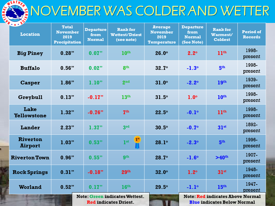
| The November 2019 climate summaries for Big Piney, Buffalo, Casper, Greybull, Lake Yellowstone, Lander, Riverton, Rock Springs, and Worland are now available online. |
 |
|
November was a mix of warm days and very cold days with the odd snow thrown in. Nothing too exciting for the month, until the last week...which was filled with snowstorms and cold temperatures. Most of our climate sites had below normal temperatures for the month, though not too far below. The only site with new temperature records was the Riverton airport, with one new high on the 9th and a new low on the 26th. Precipitation was wetter than normal for most sites except Greybull, Lake Yellowstone, and Rock Springs. Riverton Airport had their wettest November since records have been kept in 1996. There were many precipitation records broken at the sites, with the exception of Rock Springs and Worland. Two snowstorms hit during Thanksgiving week and dropped quite a bit of snow across the state, and making for some very hazardous holiday travel. Casper, Riverton Town, and Riverton Airport all had record snowfall on the 30th with that second storm. Check the CLMs for more specifics on daily records set at the various locations. See the links above for details for individual sites or click here for Water Year Precipitation summaries for more locations. If you would like additional, or more in-depth climate information, please refer to our Climate Page. From the Riverton Home Page, hover over the "Climate and Past Weather" tab, and select the "Local" option. You can then find the Daily Climate Report (CLI), the Preliminary Monthly Climate Data (CF6), the Monthly Weather Summary (CLM), and the Regional Summary (RTP). The Daily Climate Report will have the weather data for the day (from midnight to 1159 pm). The Monthly Climate Data (CF6) will have this data for each day of the month, compiling all the daily data into one form. The Regional Summary will have temperature and precipitation data for various locations across the state, updated 3 times a day. |
|

