
Heavy to excessive rainfall is forecast over north Texas into Oklahoma Tuesday. Locally catastrophic flooding will be possible across portions of southwest Oklahoma. Flood Watches have been issued. Scattered severe thunderstorms are possible within a broad swath from the lower Great Lakes to the southern High Plains Tuesday afternoon into the evening. Read More >
Links | Map | Warnings, Radar, & Satellite | Fire & Thunder Forecasts
Outlooks and Climate| Fuels and Fire Danger Maps
 |
||||||||||||||||||||||||||||||||
|
||||||||||||||||||||||||||||||||
| Berry Wildfire Inciweb Page | ||||||||||||||||||||||||||||||||
| WFO Riverton Fire Weather Page | ||||||||||||||||||||||||||||||||
| Fire Weather Planning Forecast For Zone 415 - Northern Bridger Teton National Forest and Grand Teton NP | ||||||||||||||||||||||||||||||||
| Click Boxes to Expand Product on Page | ||||||||||||||||||||||||||||||||
|
||||||||||||||||||||||||||||||||
Current Warnings, Radar, and Satellite
(Click thumbnails to expand Images)
 |
 |
|
|
Click Image to Enlarge |
|
|
|
|
 |
 |
 |
|
|
|
|
|
|
Storm Prediction Center Critical Fire Areas and Thunderstorm Forecasts
(Click thumbnails to expand Images)
|
|
|
|
 |
 |
 |
|
|
|
|
 |
 |
 |
|
|
|
|
 |
 |
 |
|
|
|
|
|
|
 |
 |
 |
 |
 |
|
|
|
|
|
|
 |

|
 |
 |
 |
|
|
|
|
|
|
 |

|
 |
 |
 |
Weather Outlook and Climate Information
(Click thumbnails to expand Images)
| Local Precipitation, Wind, and Humidity Information (NWS) |
|
|
|
|
|
 |
 |
 |
 |
|
|
|
|
|
 |
 |
 |
 |
|
|
|
|
|
|
|
 |
 |
 |
 |
|
|
|
|
|
 |
 |
 |
 |
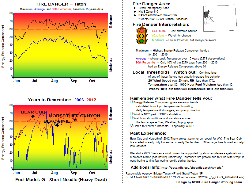
USFS Fire Danger Graphics and Fuels
(Click thumbnails to expand Images)
|
|
|
|
 |
 |
 |
|
|
|
|
|
 |
 |
 |
 |
|
|
|
|
|
 |
 |
 |
 |
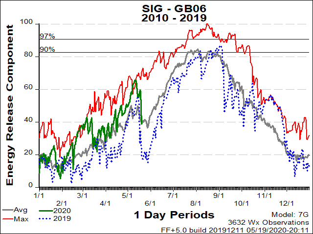
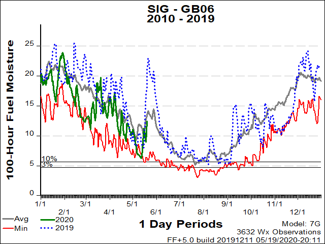
| GB06 ERC Fuels Graph |
|
|
 |
 |
 |
Return to NWS Riverton Homepage
 |
Building a Weather-Ready Nation |


