Western and Central Wyoming
Weather Forecast Office
Overview
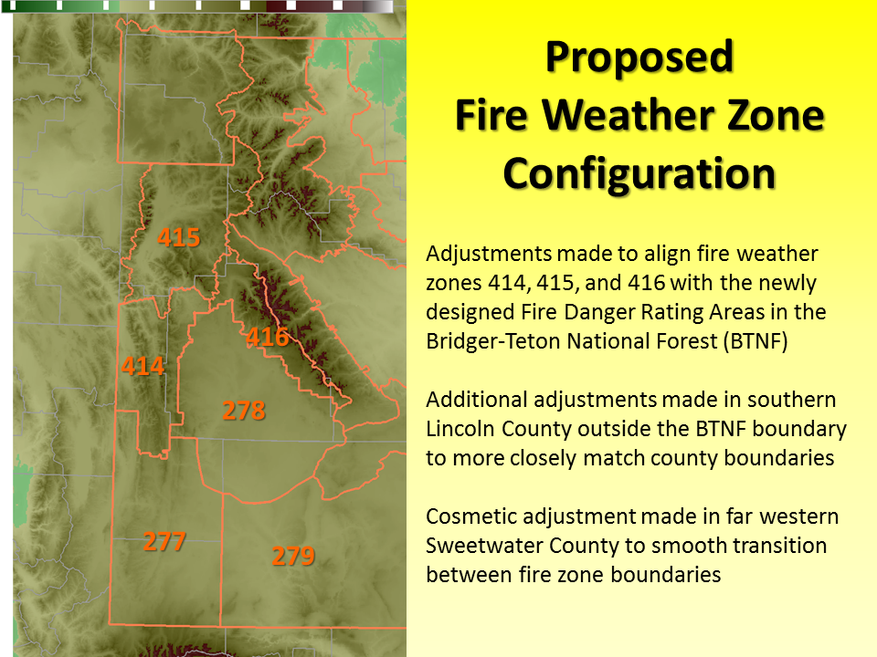
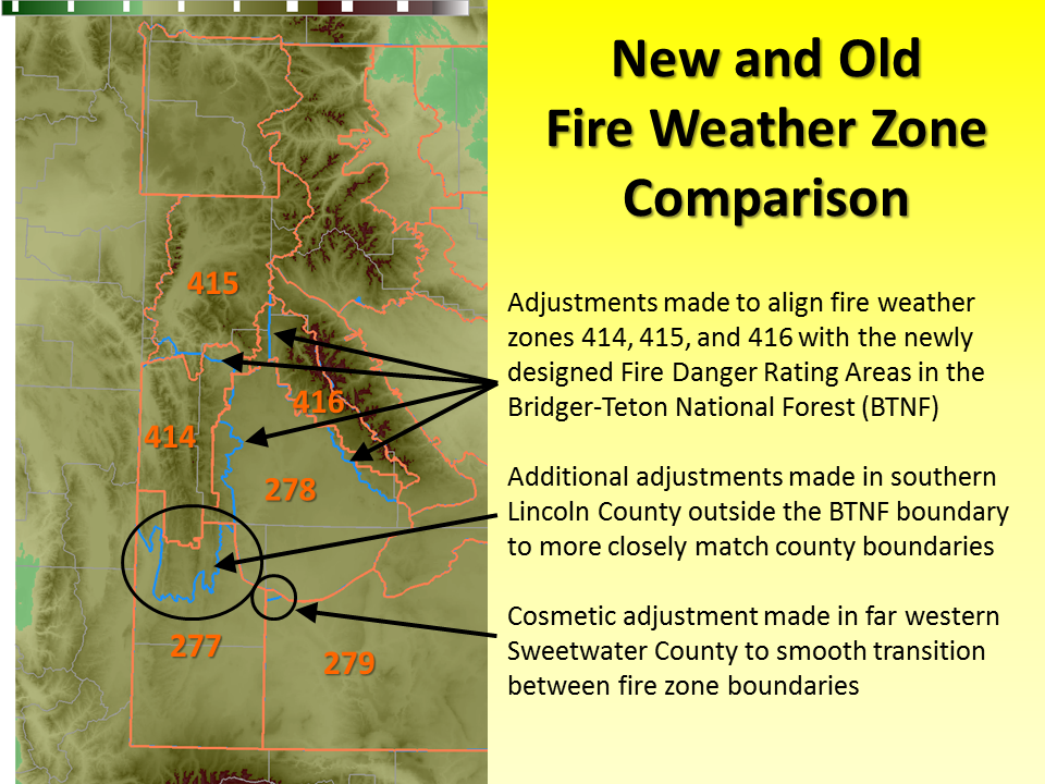
Effective midnight Monday, June 25, 2018, (0600 Coordinated Universal Time - UTC), the NWS Weather Forecast Office in Riverton, Wyoming, will change its current fire weather forecast zone boundaries in western Wyoming. Fire weather zones that will be impacted by this change include WYZ277, WYZ278, WYZ279, WYZ414, WYZ415, and WYZ416. Additionally, the NWS Weather Forecast Office in Pocatello, Idaho, will adjust the boundary of WYZ411 to ensure consistency with the altered boundary of WYZ415. Other minor cosmetic changes were made to fire weather forecast zone boundaries WY277, WYZ278, and WYZ279.
After this change, WFO RIW fire weather forecast zones covering the Bridger-Teton National Forest will align with the Fire Danger Rating Areas of that forest. These changes were initiated by the partner and will improve services for partners in western Wyoming. Fire weather forecast zone numbers will not change as a result of these zone boundary adjustments.
Maps
Graphical descriptions of the old and new fire weather forecast zones are available below.
| Current Western Wyoming Fire Zone Boundary Map |
 |
| Proposed Western Wyoming Fire Zone Boundary Map |
 |
| Comparison Map of Current & Proposed Western Wyoming Fire Zone Boundaries |
 |
Text Products
NWS watch, warning and forecast products affected by these changes are:
| Product | WMO Heading | AWIPS ID |
| NWS Riverton Fire Weather Watch | WWUS85 KRIW | RFWRIW |
| NWS Riverton Red Flag Warning | WWUS85 KRIW | RFWRIW |
| NWS Riverton Fire Weather Planning Forecast | FNUS55 KRIW | FWFRIW |
| NWS Pocatello Fire Weather Watch | WWUS85 KPIH | RFWPIH |
| NWS Pocatello Red Flag Warning | WWUS85 KPIH | RFWPIH |
| NWS Pocatello Fire Weather Planning Forecast | FNUS55 KPIH | FWFPIH |
NWS partners and users will need to make necessary changes to their communications systems to accommodate these fire weather forecast zone changes.
A shapefile of the new fire weather forecast zones for WFO RIW and WFO PIH is online at: http://www.nws.noaa.gov/geodata/catalog/wsom/html/firezone.htm
For more information, please contact:
Tim Troutman - Warning Coordination Meteorologist
12744 West US Highway 26
Riverton, WY 82501
307-857-3898 ext. 726
tim.troutman@noaa.gov
National Service Change Notices are online at: http://www.weather.gov/os/notif.htm
Forecasts
Severe Weather
Forecast Discussion
User Defined Forecast
Fire Weather
Activity Planner
Hourly Forecasts
Snow and Avalanche
Aviation Weather Decision Support
Hydrology
SnoTel Page
Rivers and Lakes
Weather Safety
StormReady
NOAA Weather Radio
Preparedness
SkyWarn
US Dept of Commerce
National Oceanic and Atmospheric Administration
National Weather Service
Western and Central Wyoming
12744 West U.S. Hwy 26
Riverton, WY 82501
307-857-3898
Comments? Questions? Please Contact Us.

