
Strong to severe thunderstorms may produce heavy to excessive rainfall over portions of the Central/Southern Plains and Mississippi Valley today. There is a Slight Risk (Level 2 of 4) for Excessive Rainfall and a Slight Risk (Level 2 of 5) for severe thunderstorms today. Elevated fire weather conditions are possible over parts of western Florida today. Read More >
Snowpack in the higher elevations of the southern Wind River Range remained climatologically high during the month of May due to much colder than normal temperatures and above normal precipitation across the region. The average temperature for the month of May at Lander, WY tied for the fifth coldest on record at 46.8 degrees F, and the average temperature for May at Riverton, WY tied for the 3rd coldest on record at 48.5 degrees F. High temperatures peaked in the mid to upper 70s in the lower elevations of the Wind River Basin June 4th and 5th, as high pressure strengthened across the northern Rockies. This warmer weather pattern resulted in high temperatures in the 50s at elevations above 9,000 feet in the southern Wind River range on June 4th and 5th. Low temperatures during the morning hours of June 5th and June 6th were well above freezing in the elevations above 9,000 feet, ranging from the upper 30s to mid 40s. The combination of warm days and above freezing nightime temperatures caused rapid snowmelt at the higher elevations and rapid rises in the Middle Popo Agie and Little Popo Agie Rivers, beginning on the afternoon of June 4th. This resulted in minor flooding of these rivers late on June 4th into June 5th, which affected low lying areas in the towns of Lander and Hudson. Continued snowmelt on June 5th and the morning of June 6th has kept the levels of the Middle Popo Agie above 6 feet at Sinks Canyon this morning with minor flooding occurring in the Lander area. More serious flooding occurred during the afternoon of June 5th through this morning, June 6th, along the Little Popo Agie River. The Little Popo Agie River has flooded riverside properties in Hudson, WY, including homes on the west side of the town. The Little Wind River rose above flood stage Saturday evening, and has continued to rise since that time. Homes were evacuated along Left Hand Ditch road and Rendezvous road the morning of Tuesday, June 8th.
Additional snowmelt as well as precipitation that is forecast for late this week could increase flooding in these areas.
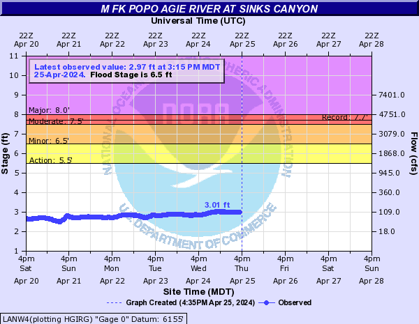
After peaking at a river stage of 7.5 feet at midnight Monday night (flood stage is 6.5 feet), the middle fork of the Popo Agie River had receded below flood stage to 5.71 feet as of 4:15 AM the morning of Wednesday, June 9th.
The Little Wind River remains above major flood stage, running higher than at any other recorded time. At 4:15 AM Wednesday, the river was at 11.74 feet, after a peak of 11.91 feet at 1:15 AM. The highest previous crest of 10.85 feet occurred on June 17, 1963.
Keep up with the latest watches and warnings here.

Pictures of the flooding from Monday and Tuesday provided by NWS Meteorologist Chuck Baker
(click pictures for full size).

Flooding on the Ruby Ranch north of Lander
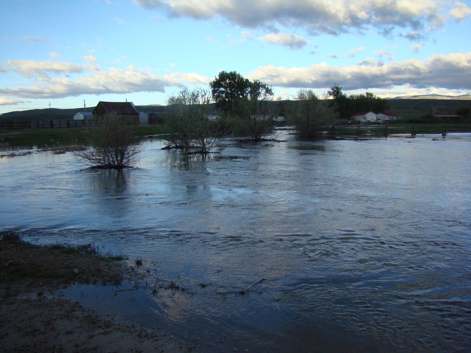
Fields Flooded on the Ruby Ranch north of Lander

River Outside its Bank Flowing across the Ruby Ranch north of Lander

Iowa Avenue in Hudson, WY under water

Longer range View of Iowa Avenue in Hudson, WY

Residential Flooding on Kansas Avenue in Hudson, WY

Flooded Campground on the Little Wind River in Southeastern Riverton

Mortimore Lane Bridge Prior to Collapse

Residential Flooding in South Lander

Middle Fork of the Popo Agie River in South Lander

