HOME
FORECAST
Local
Graphical
Aviation
Marine
Rivers and Lakes
Hurricanes
Severe Weather
Fire Weather
Sunrise/Sunset
Long Range Forecasts
Climate Prediction
Space Weather
PAST WEATHER
Past Weather
Astronomical Data
Certified Weather Data
SAFETY
INFORMATION
Wireless Emergency Alerts
Weather-Ready Nation
Brochures
Cooperative Observers
Daily Briefing
Damage/Fatality/Injury Statistics
Forecast Models
GIS Data Portal
NOAA Weather Radio
Publications
SKYWARN Storm Spotters
StormReady
TsunamiReady
Service Change Notices
EDUCATION
NEWS
SEARCH
Search For
NWS
All NOAA
ABOUT
About NWS
Organization
For NWS Employees
National Centers
Careers
Contact Us
Glossary
Social Media
NWS Transformation
Local forecast by
"City, St" or ZIP code
Sorry, the location you searched for was not found. Please try another search.
Multiple locations were found. Please select one of the following:
Location Help
News Headlines
NC State Climate Office Rapid Reaction: Heavy Rains Return, Promising Drought Relief
Virtual Class Opportunity: NWS Raleigh 2026 Tropical SKYWARN Class - 7 PM Wednesday August 20, 2026 - no cost to attend
Customize Your
Weather.gov
Enter Your City, ST or ZIP Code
Remember Me
LOADING...
Raleigh, NC
Weather Forecast Office
Weather Story for Central North Carolina
Weather.gov
>
Raleigh, NC
> Weather Story for Central North Carolina
Current Hazards
River Flooding
Briefing Page
Local Outlook
Space
Winter
Drought
Thunderstorms
Hurricanes
Current Conditions
Air Quality
Satellite
Observations (Map)
Rainfall
Observations (List)
Southeastern US Satellite Imagery
Statewide Observations Table
Radar
Local KRAX Enhanced Radar
Local KRAX Standard Radar (low bandwidth)
Regional Standard Radar (low bandwidth)
National Standard Radar (low bandwidth)
Forecasts
Map View
Tropical
Hourly View
Forecasters' Discussion
Aviation
Fire Weather
Marine
Probabilistic Rain Forecast
Snow and Ice Forecasts / Snow Probabilities
WFO RAH Forecast Suite
Long Range Outlooks
Rivers and Lakes
Current & Past Streamflow
Ensemble River Guidance
River Observations (Map)
River Forecast Centers
River Forecasts (Map)
Local Hydrographs
Local MMEFS (Ensemble River Guidance) Page
Local Products
Climate and Past Weather
CoCoRaHS
24 Hour Summary
Snowfall Records
Past Observed Weather
Past Rainfall
Drought Outlook
Climate Prediction
Graphical Climate Plots
RDU Daily Normals
GSO Daily Normals
FAY Daily Normals
Frost/Freeze Information and Climatology
Tropical Cyclone Reports
Local Programs
P-Type Nomograms / Partial Thicknesses
Excessive Heat Danger Awareness
Wet Bulb Globe Temperatures
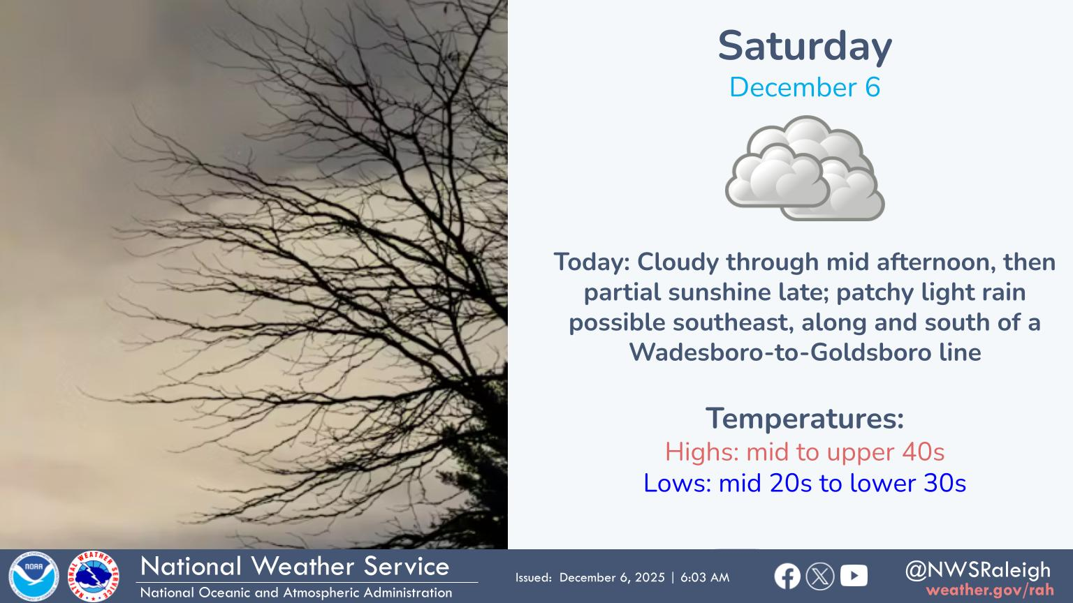
Dry weather today. Showers in the west tonight.
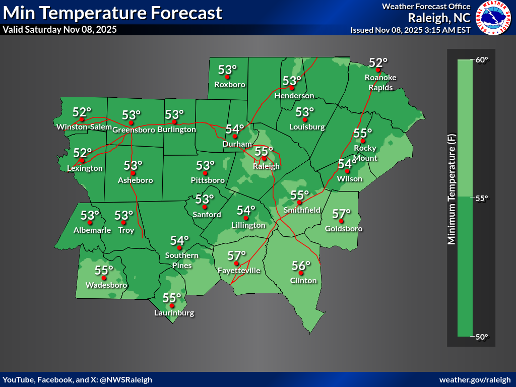
High Temps
Low Temps
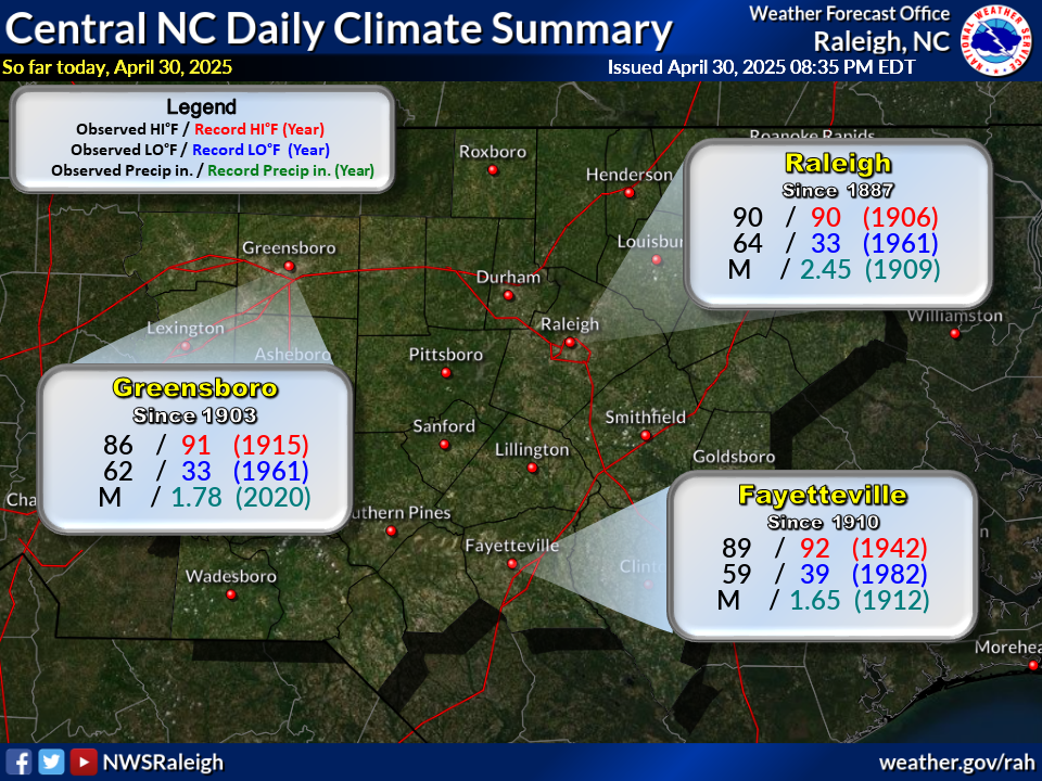
Daily Climate Summary for Central NC
Today will be the drier of the days this weekend. We may see some showers move into the western Piedmont late this evening into tonight, but better chances will exist areawide on Sunday. #NCwx
Read More...
Here is the high temperature forecast.
Read More...
Here is the low temperature forecast.
Read More...
The daily climate summary is issued each day by 5:00 pm.
Read More...
Radar
Current Weather
Rivers & Lakes
Satellite
Forecast Maps
Hour by Hour Forecast
Tropical Weather
Graphical Hazards
Climate Plots
Fire Weather
Heat Safety
Drought Information
Weather Hazard Briefing
Statewide Maps
Forecaster Discussion
Text Bulletins
SKYWARN
Follow us on X
Follow us on Facebook
Follow us on YouTube
RAH RSS Feed


 Heat Safety
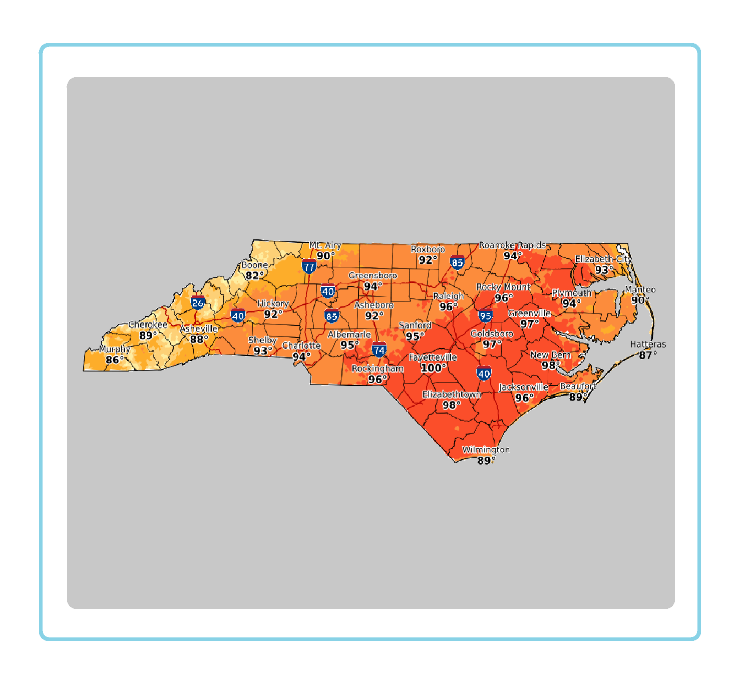 Statewide Maps
 Forecaster Discussion