
Public Information Statement
National Weather Service Raleigh NC
726 PM EDT Thu Jul 8 2021

...PRECIPITATION REPORTS FOR THE LAST 24 HOURS ACROSS CENTRAL NORTH CAROLINA...

Location                     Amount    Time/Date       Provider

...North Carolina...

...Alamance County...
Haw River                    1.03 in   0515 PM 07/08   HADS
1 WNW Burlington             0.90 in   0555 PM 07/08   AWS
Elon College                 0.88 in   0555 PM 07/08   AWS
Burlington                   0.77 in   0554 PM 07/08   ASOS

...Anson County...
Wadesboro Anson              1.80 in   0555 PM 07/08   AWOS
6.2 E Lilesville             1.26 in   0600 PM 07/08   COOP

...Chatham County...
Pittsboro                    2.80 in   0600 PM 07/08   CWOP
Siler City                   1.94 in   0556 PM 07/08   CWOP
Pittsboro                    1.67 in   0546 PM 07/08   CWOP
6 N Bynum                    1.59 in   0555 PM 07/08   AWS
Siler City                   1.51 in   0555 PM 07/08   AWOS

...Cumberland County...
Hope Mills                   3.26 in   0600 PM 07/08   CWOP
Usfs Met Stn At Fort Bragg   2.91 in   0414 PM 07/08   RAWS
Fayetteville 5.9 SW          2.90 in   0245 PM 07/08   COCORAHS
Fayetteville                 2.83 in   0555 PM 07/08   CWOP
Fort Bragg Simmo             2.75 in   0556 PM 07/08   AWOS
Fayetteville                 2.44 in   0600 PM 07/08   CWOP
Fayetteville                 1.89 in   0553 PM 07/08   ASOS

...Davidson County...
Lexington 6.1 SE             0.57 in   0600 PM 07/08   COCORAHS
High Point                   0.55 in   0550 PM 07/08   CWOP
Greensboro                   0.36 in   0557 PM 07/08   CWOP
Lexington                    0.32 in   0516 PM 07/08   RAWS
1.7 E Lexington              0.30 in   0540 PM 07/08   USGS
Winston-Salem                0.28 in   0555 PM 07/08   CWOP

...Durham County...
2 NNE Bethesda               2.48 in   0555 PM 07/08   AWS
Durham                       2.31 in   0545 PM 07/08   CWOP
Durham                       2.30 in   0559 PM 07/08   CWOP
Durham                       2.28 in   0557 PM 07/08   CWOP
Hillsborough                 2.12 in   0556 PM 07/08   CWOP
Durham                       2.02 in   0556 PM 07/08   CWOP
2.1 S Durham                 1.91 in   0550 PM 07/08   HADS
2.6 NE Bethesda              1.84 in   0545 PM 07/08   HADS
2.3 W Durham                 1.76 in   0530 PM 07/08   HADS
3.4 N Durham                 1.66 in   0600 PM 07/08   HADS
3.3 NW Parkwood              1.51 in   0530 PM 07/08   HADS
Rougemont                    1.23 in   0555 PM 07/08   CWOP
Durham                       1.04 in   0546 PM 07/08   CWOP
6.5 NW Durham                0.88 in   0600 PM 07/08   HADS

...Edgecombe County...
Rocky Mount                  1.25 in   0545 PM 07/08   HADS

...Forsyth County...
Walkertown                   0.33 in   0547 PM 07/08   CWOP

...Franklin County...
Youngsville 3.9 WNW          4.43 in   0530 PM 07/08   COCORAHS
1 NE Purnell                 3.47 in   0555 PM 07/08   AWS
Youngsville                  3.15 in   0546 PM 07/08   CWOP
1 ESE Louisburg              2.12 in   0600 PM 07/08   AWS

...Granville County...
Creedmoor                    3.26 in   0550 PM 07/08   CWOP
Creedmoor                    2.77 in   0545 PM 07/08   CWOP
Henderson Oxford             2.68 in   0535 PM 07/08   AWOS

...Guilford County...
Greensboro                   1.09 in   0545 PM 07/08   CWOP
Pleasant Garden              0.67 in   0556 PM 07/08   CWOP
Greensboro                   0.59 in   0557 PM 07/08   CWOP
3.2 SE Greensboro            0.56 in   0545 PM 07/08   HADS
High Point                   0.53 in   0556 PM 07/08   CWOP
Greensboro                   0.50 in   0545 PM 07/08   CWOP
2.8 NE Greensboro            0.49 in   0545 PM 07/08   HADS
Greensboro                   0.48 in   0555 PM 07/08   CWOP
1.7 N Mcleansville           0.43 in   0530 PM 07/08   HADS
Greensboro                   0.41 in   0554 PM 07/08   ASOS
5.1 N Forest Oaks            0.40 in   0530 PM 07/08   HADS
High Point                   0.40 in   0547 PM 07/08   CWOP
Greensboro                   0.38 in   0550 PM 07/08   CWOP
4.5 NW Greensboro            0.32 in   0545 PM 07/08   HADS
3.9 SW Summerfield           0.30 in   0530 PM 07/08   HADS
2.9 W Mcleansville           0.25 in   0530 PM 07/08   HADS

...Harnett County...
Lillington                   3.11 in   0556 PM 07/08   CWOP
Lillington 11.0 WSW          2.85 in   0358 PM 07/08   COCORAHS
Mamers                       2.39 in   0600 PM 07/08   CWOP
Erwin                        1.96 in   0555 PM 07/08   AWOS
Buies Creek                  1.85 in   0600 PM 07/08   AWS
Dunn                         1.62 in   0556 PM 07/08   CWOP

...Hoke County...
Raeford                      3.54 in   0555 PM 07/08   CWOP
Raeford                      2.77 in   0559 PM 07/08   CWOP

...Johnston County...
Four Oaks                    3.86 in   0555 PM 07/08   CWOP
Garner                       3.77 in   0559 PM 07/08   CWOP
Smithfield                   3.30 in   0555 PM 07/08   CWOP
Zebulon /Emit                3.19 in   0551 PM 07/08   CWOP
1 WSW Coats Crossroads       3.11 in   0600 PM 07/08   AWS
Pine Level                   2.90 in   0559 PM 07/08   CWOP
1 NE Emit                    2.59 in   0600 PM 07/08   AWS
Kenly                        2.55 in   0559 PM 07/08   CWOP
Clayton                      2.45 in   0600 PM 07/08   CWOP
Clayton                      2.40 in   0600 PM 07/08   AWS
Kenly                        2.35 in   0600 PM 07/08   AWS
3 NW Flowers                 2.33 in   0600 PM 07/08   AWS
4 N Newton Grove             2.02 in   0600 PM 07/08   AWS
Princeton                    1.58 in   0600 PM 07/08   AWS

...Lee County...
Gum Springs                  4.02 in   0555 PM 07/08   AWS
Sanford                      2.65 in   0555 PM 07/08   AWOS

...Montgomery County...
3.4 E Norwood                2.64 in   0600 PM 07/08   COOP

...Moore County...
Whispering Pines             3.18 in   0557 PM 07/08   CWOP
Carthage                     2.94 in   0555 PM 07/08   CWOP
Southern Pines               1.80 in   0556 PM 07/08   AWOS
Pinehurst                    0.85 in   0555 PM 07/08   CWOP

...Nash County...
Rocky Mount                  1.50 in   0553 PM 07/08   ASOS

...Orange County...
DUKE FOREST DURHAM 11 W      2.09 in   0600 PM 07/08   HADS
Chapel Hill                  2.05 in   0558 PM 07/08   CWOP
Chapel Hill                  2.04 in   0546 PM 07/08   CWOP
Duke Forest Met Sta Nr Chape 1.94 in   0516 PM 07/08   RAWS
Efland                       1.91 in   0545 PM 07/08   CWOP
Hurdle Mills                 1.83 in   0547 PM 07/08   CWOP
Efland                       1.61 in   0555 PM 07/08   CWOP
Hillsborough                 1.21 in   0546 PM 07/08   CWOP

...Person County...
Mebane                       1.20 in   0555 PM 07/08   CWOP

...Randolph County...
Liberty                      1.58 in   0547 PM 07/08   CWOP
Asheboro                     0.97 in   0555 PM 07/08   CWOP
1 WNW Asheboro               0.97 in   0555 PM 07/08   AWS
Asheboro Muni                0.82 in   0555 PM 07/08   AWOS

...Richmond County...
5 ENE Rockingham             2.74 in   0545 PM 07/08   RAWS
Rockingham                   1.91 in   0555 PM 07/08   AWOS

...Sampson County...
Clinton                      1.90 in   0555 PM 07/08   AWOS

...Scotland County...
Laurinburg                   3.42 in   0559 PM 07/08   CWOP
Maxton                       2.86 in   0552 PM 07/08   ASOS
Hoffman Mackall              2.83 in   0556 PM 07/08   AWOS

...Stanly County...
Richfield                    0.35 in   0600 PM 07/08   AWS

...Wake County...
Wake Forest                  4.73 in   0600 PM 07/08   CWOP
Wake Forest                  4.55 in   0553 PM 07/08   CWOP
Willow Spring                3.54 in   0558 PM 07/08   CWOP
Raleigh                      3.38 in   0555 PM 07/08   CWOP
1 WNW Coats Crossroads       3.10 in   0600 PM 07/08   CWOP
Fuquay Varina                3.03 in   0555 PM 07/08   CWOP
Cary                         2.96 in   0556 PM 07/08   CWOP
1.9 E Raleigh                2.94 in   0545 PM 07/08   HADS
Fuquay Varina                2.85 in   0551 PM 07/08   CWOP
4.4 N Garner                 2.84 in   0550 PM 07/08   HADS
Apex                         2.77 in   0545 PM 07/08   CWOP
Apex                         2.75 in   0556 PM 07/08   CWOP
Apex                         2.74 in   0550 PM 07/08   CWOP
Cary                         2.74 in   0600 PM 07/08   CWOP
2.2 S Rdu International      2.71 in   0555 PM 07/08   HADS
Raleigh                      2.64 in   0557 PM 07/08   CWOP
Fuquay Varina                2.57 in   0547 PM 07/08   CWOP
1 WSW Lake Wheeler           2.57 in   0555 PM 07/08   AWS
Apex                         2.49 in   0548 PM 07/08   CWOP
4.1 SW Raleigh               2.46 in   0550 PM 07/08   HADS
6.8 S Creedmoor              2.43 in   0545 PM 07/08   USGS
Holly Springs                2.36 in   0554 PM 07/08   CWOP
4.4 N Lake Wheeler           2.29 in   0505 PM 07/08   HADS
2.4 S Raleigh                2.26 in   0545 PM 07/08   HADS
Apex                         2.23 in   0545 PM 07/08   CWOP
Cary                         2.17 in   0556 PM 07/08   CWOP
Raleigh Durham               2.52 in   0551 PM 07/08   ASOS
2.9 S Raleigh                2.15 in   0550 PM 07/08   HADS
Creedmoor                    2.12 in   0551 PM 07/08   CWOP
2.2 NW Lake Wheeler          2.10 in   0550 PM 07/08   HADS
Cary                         2.10 in   0558 PM 07/08   CWOP
2 W Cary                     2.09 in   0600 PM 07/08   AWS
4 SSW Garner                 2.05 in   0600 PM 07/08   AWS
Holly Springs                1.93 in   0546 PM 07/08   CWOP
0.8 N Falls Lake             1.58 in   0600 PM 07/08   HADS
Raleigh                      1.20 in   0555 PM 07/08   CWOP

...Warren County...
Warrenton                    2.66 in   0516 PM 07/08   RAWS

...Wayne County...
3 N Mar-Mac                  1.91 in   0555 PM 07/08   AWS
Goldsboro S. J.              1.53 in   0556 PM 07/08   AWOS
Goldsboro Wayne              1.45 in   0555 PM 07/08   AWOS
FinchS Station              1.41 in   0414 PM 07/08   RAWS
&&
Public Information Statement
National Weather Service Raleigh NC
919 PM EDT Thu Jul 8 2021

...HIGHEST WIND REPORTS FROM ELSA...

Location                     Speed     Time/Date       Provider

...North Carolina...

...Alamance County...
Burlington                   26 MPH    1254 PM 07/08   ASOS

...Anson County...
Wadesboro Anson              22 MPH    0155 PM 07/08   AWOS

...Chatham County...
Siler City                   23 MPH    1155 AM 07/08   AWOS
Pittsboro                    21 MPH    0955 AM 07/08   CWOP
Siler City                   20 MPH    1134 AM 07/08   CWOP

...Cumberland County...
Fayetteville                 38 MPH    0404 PM 07/08   ASOS
Fort Bragg Simmo             33 MPH    0429 PM 07/08   AWOS
Usfs Met Stn At Fort Bragg   31 MPH    0414 PM 07/08   RAWS
Fayetteville                 31 MPH    0450 PM 07/08   CWOP
Pope AFB                     29 MPH    0326 PM 07/08   AWOS
Hope Mills                   25 MPH    0810 AM 07/08   CWOP
Fayetteville                 22 MPH    1120 AM 07/08   CWOP
Fayetteville                 21 MPH    0433 PM 07/08   CWOP

...Davidson County...
Davidson Cty Ap              25 MPH    0955 AM 07/08   AWOS
Winston-Salem                21 MPH    1240 PM 07/08   CWOP
Lexington                    21 MPH    1216 PM 07/08   RAWS

...Edgecombe County...
Tarboro                      29 MPH    0315 PM 07/08   AWOS

...Forsyth County...
Winston Salem                23 MPH    0501 PM 07/08   ASOS
1.8 SE Pfafftown (WEATHERSTE 21 MPH    1130 AM 07/08   MESOWEST

...Franklin County...
Louisburg Frankl             26 MPH    0215 PM 07/08   AWOS
Castalia                     20 MPH    0833 PM 07/08   CWOP

...Granville County...
Henderson Oxford             25 MPH    0715 PM 07/08   AWOS

...Guilford County...
Greensboro                   26 MPH    0214 PM 07/08   ASOS
1.2 SE Greensboro (WEATHERST 23 MPH    1220 PM 07/08   MESOWEST
3.6 W Greensboro (WEATHERSTE 21 MPH    0130 PM 07/08   MESOWEST
Greensboro                   20 MPH    1237 PM 07/08   CWOP

...Halifax County...
Halifax-northampton Regional 31 MPH    0835 PM 07/08   AWOS

...Harnett County...
Erwin                        28 MPH    0915 AM 07/08   AWOS
Mamers                       22 MPH    0915 AM 07/08   CWOP
Dunn                         21 MPH    0516 PM 07/08   CWOP

...Hoke County...
Raeford                      25 MPH    1023 AM 07/08   CWOP
Raeford                      24 MPH    0345 PM 07/08   CWOP

...Johnston County...
Clayton                      29 MPH    0123 PM 07/08   CWOP
Pine Level                   28 MPH    0144 PM 07/08   CWOP
Four Oaks                    26 MPH    0440 PM 07/08   CWOP
Kenly                        25 MPH    1227 PM 07/08   CWOP
Smithfield Johns             24 MPH    0115 PM 07/08   AWOS
Smithfield                   20 MPH    1235 PM 07/08   CWOP

...Lee County...
Sanford                      21 MPH    0455 PM 07/08   AWOS

...Moore County...
Southern Pines               30 MPH    1055 AM 07/08   AWOS
Horseshoe House              23 MPH    0415 PM 07/08   RAWS

...Nash County...
3 NNW Bailey                 30 MPH    0730 PM 07/08   AWS
Rocky Mount                  30 MPH    0742 PM 07/08   ASOS

...Orange County...
Duke Forest Met Sta Nr Chape 24 MPH    1216 PM 07/08   RAWS

...Person County...
Roxboro Person               25 MPH    1235 PM 07/08   AWOS

...Randolph County...
Asheboro Muni                21 MPH    1215 PM 07/08   AWOS
Asheboro                     20 MPH    1151 AM 07/08   CWOP

...Richmond County...
Rockingham                   25 MPH    0315 PM 07/08   AWOS

...Sampson County...
1.2 E Clinton (WEATHERSTEM)  37 MPH    1130 AM 07/08   MESOWEST
Clinton                      32 MPH    0255 PM 07/08   AWOS

...Scotland County...
Maxton                       33 MPH    0453 PM 07/08   ASOS
Hoffman Mackall              30 MPH    1020 AM 07/08   AWOS

...Stanly County...
Albemarle Stanly             29 MPH    0935 AM 07/08   AWOS

...Wake County...
3.7 W Raleigh (WEATHERSTEM)  36 MPH    1140 AM 07/08   MESOWEST
Raleigh Durham               31 MPH    1200 PM 07/08   ASOS
2.8 S Raleigh (WEATHERSTEM)  27 MPH    1130 AM 07/08   MESOWEST
Wake Forest                  26 MPH    1203 PM 07/08   CWOP
3.6 S Raleigh (WEATHERSTEM)  23 MPH    0730 PM 07/08   MESOWEST
2.7 SW Raleigh (WEATHERSTEM) 22 MPH    1130 AM 07/08   MESOWEST
Cary                         22 MPH    1236 PM 07/08   CWOP
Raleigh                      20 MPH    0715 PM 07/08   CWOP

...Warren County...
Warrenton                    28 MPH    0816 PM 07/08   RAWS

...Wayne County...
Goldsboro S. J.              37 MPH    0617 PM 07/08   AWOS
Goldsboro Wayne              33 MPH    1255 PM 07/08   AWOS
FinchS Station              30 MPH    0414 PM 07/08   RAWS
&&

(More satellite imagery for Elsa can be found on the NESDIS GOES Image Viewer)


 Heat Safety
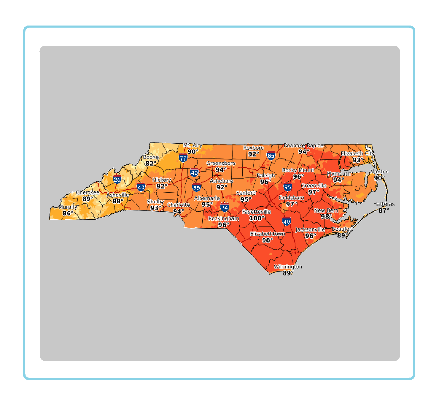 Statewide Maps
 Forecaster Discussion