|
Dissecting a Thunderstorm with Radar
by Rod Gonski
Weather forecasters at the National Weather Service use radar to literally slice through thunderstorms electronically to see inside much the way you might slice an apple in half vertically to see its core.
Every thunderstorm has an updraft, a channel of rapidly rising air, or wind moving straight up in the center of the storm. The strength of a thunderstorm is related to the strength of its updraft. Updrafts in severe thunderstorms typically reach 50 mph, and sometimes over 100 mph. An updraft that strong can hold aloft large hail the size of golf balls, baseballs, or even grapefruit!
By slicing a thunderstorm in half with radar, we can see when a strong thunderstorm updraft holds heavy raindrops and hail aloft, the way a fountain appears to hold water in an arching pattern aloft. (See illustration below.)
 |
Figure 1 shows a radar image containing a thunderstorm over northern Sampson County at 4:30 PM EDT on May 15, 1995. This is a typical overhead view of the storm the way it is often displayed in weather broadcasts on television. In order to see the effects of the storm's updraft, a vertical slice was taken of the storm along a line in Figure 1 through the strongest part of the storm.
Figure 2 shows the vertical slice on a graph with the vertical scale representing altitude in thousands of feet and the horizontal scale in nautical miles from the northwest end point on the left to the southeast point on the right.
The arch-shaped pattern with the most intense signal, black shade, indicating large hail just above the arch, is a classic pattern for a severe thunderstorm. This indicates that the updraft was very strong and was holding large hail aloft and allowing it to grow even larger. Once revealed to National Weather Service forecasters, a severe thunderstorm warning was issued promptly for this storm in northern Sampson County.
An effective way of demonstrating hail being held aloft by a channel of air is to balance a ping pong ball in the stream of air from a hair drier pointed up. In this demonstration, the hair drier airstream represents the updraft of a thunderstorm and the ping pong ball, the hail. Even more visually effective is to project a transparency of the thunderstorm cross-section in Figure 2. Then balance the ping pong ball in a stream of air in front of the projection such that its shadow is superimposed on the thunderstorm radar image at the location of the largest hail above the arch.
|


 Heat Safety
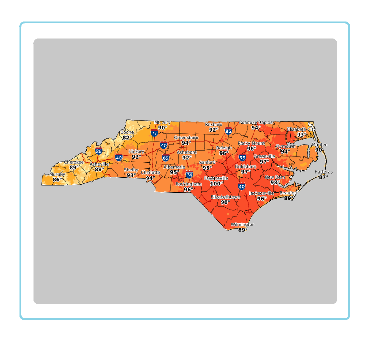 Statewide Maps
 Forecaster Discussion