This week is North Carolina’s annual Hurricane Preparedness Week. This week the National Weather Service and the North Carolina Department of Public Safety are teaming up to bring this hurricane safety campaign to all of North Carolina’s residents. With warmer weather quickly approaching, now is the time to prepare for hurricane season. If each North Carolina resident would take a few moments this week to learn about hurricane safety and implement a hurricane safety plan, then we would all be better off when hurricanes threaten our area. Remember you should prepare EACH and EVERY YEAR, as it only takes ONE Storm!
Please join us in promoting hurricane preparedness during this year's "Hurricane Preparedness Week". The National Weather Service asks emergency management, public safety officials, local media and Weather-Ready Nation Ambassadors to help join forces in improving the nation's readiness, responsiveness, and overall resilience against hurricanes during the upcoming season.
| Day of The Week | Topics |
|---|---|
| Sunday | Determine Your Risk |
| Monday | Develop an Evacuation Plan/Storm Surge |
| Tuesday | Assemble Disaster Supplies/High Winds |
| Wednesday | Get an Insurance Checkup/Inland Flooding |
| Thursday | Strengthen Your Home/Tornadoes |
| Friday | Help Your Neighbor/Rip Currents |
| Saturday | Complete a Written Plan |
Click on the tabs below for more hurricane preparedness information.
Sunday
Determine Your Risk
Public Information Statement Day 1 (good for more detailed text)
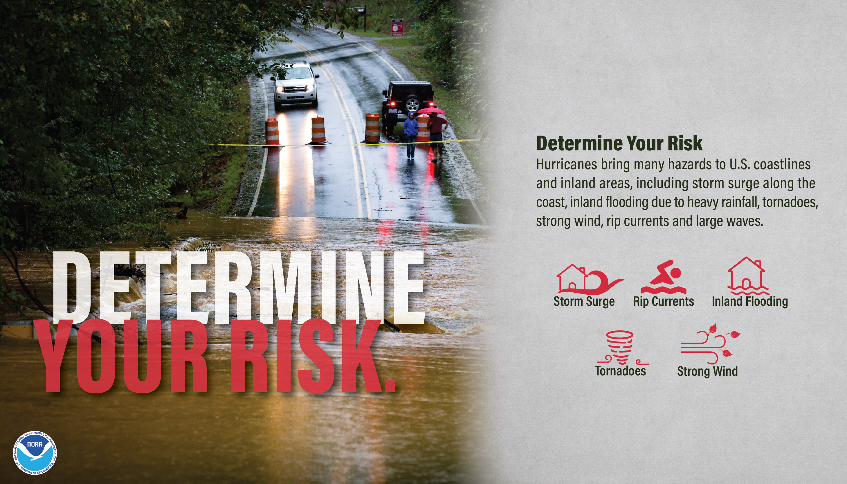
Determine Your Risk Where You Live
What Are The Impacts From Any Tropical System?
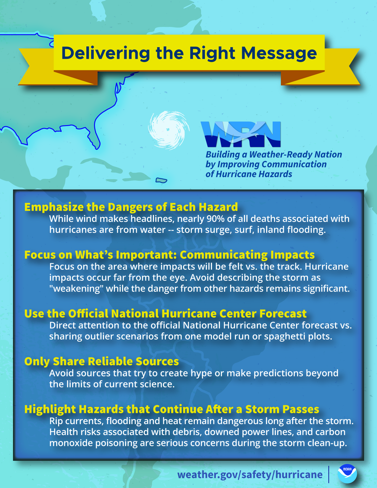
Did you know that hurricanes or any tropical system can have FIVE major impacts? These include storm surge, flooding, strong wind, tornadoes and rip currents. Today's topic is determining your risk. North Carolina is one of the most hurricane ravaged states in the country. The entire state, from the mountains to the coast, is susceptible to hurricane and tropical storm impacts. The coastal areas of the state can be susceptible to storm surge, high winds, flooding and tornadoes. The central portion of the state can be susceptible to inland freshwater flooding, high winds and tornadoes; and the western portion of the state can be susceptible to inland freshwater flooding, high winds, and tornadoes; and the western portion of the state can be susceptible to tornadoes, flash flooding, and resulting landslides from heavy rains. Even when hurricanes stay out to sea, the North Carolina coast can still be impacted by large swells and deadly rip currents!
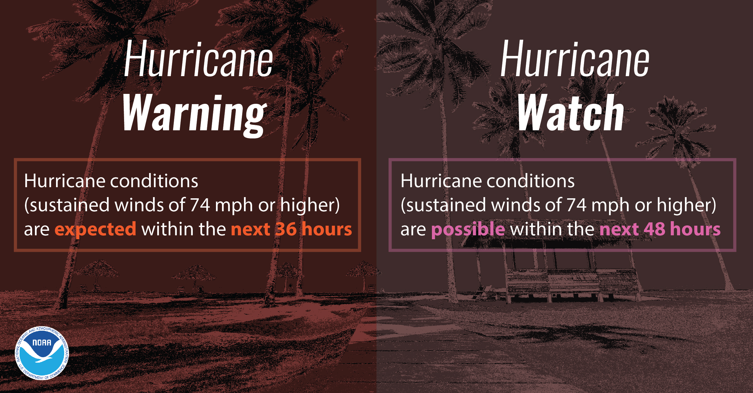
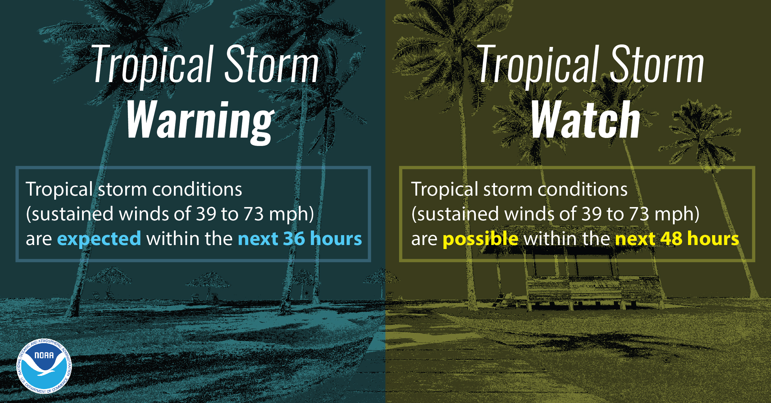
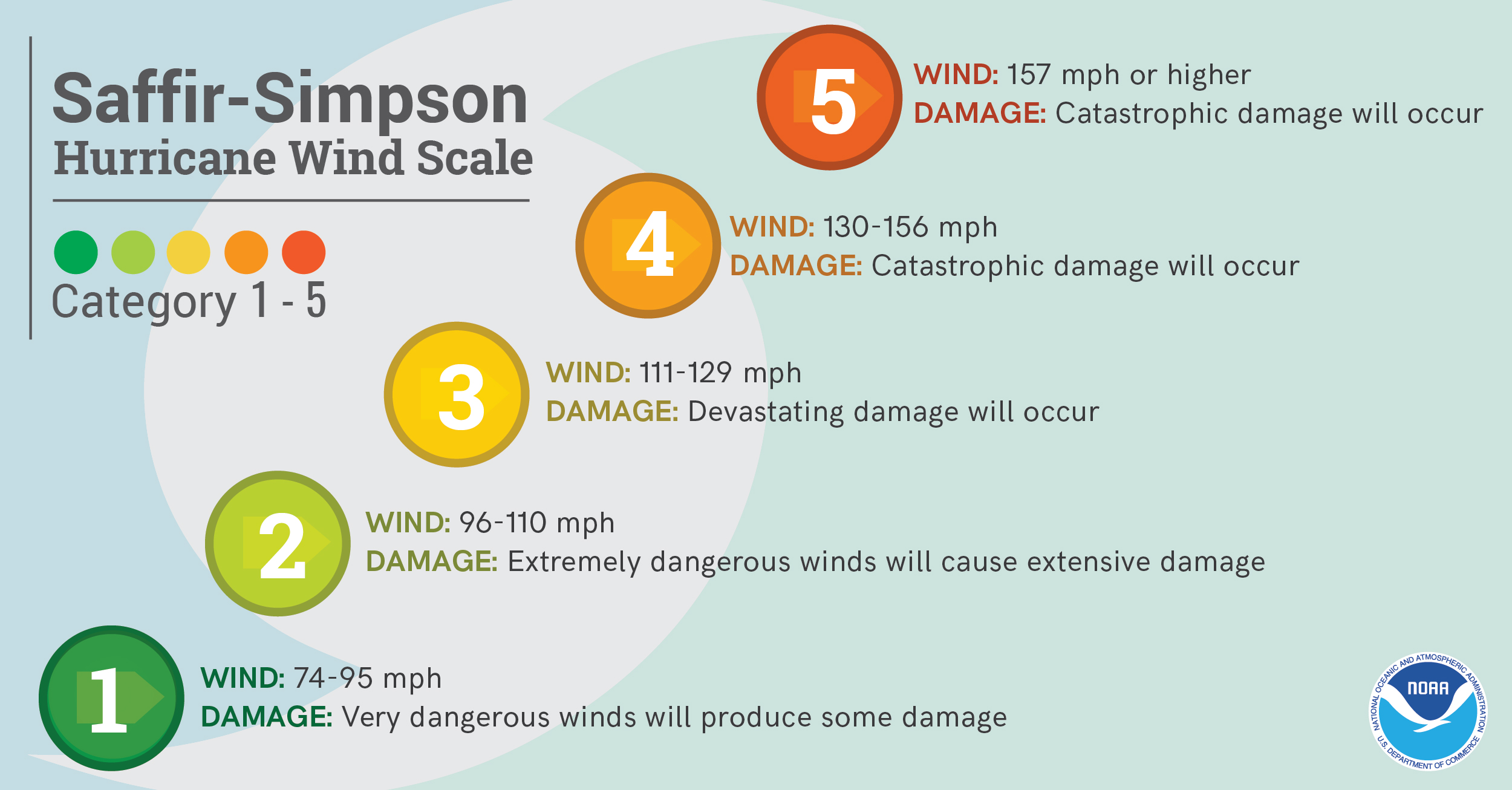
Why Should I Not Focus On The Category Alone?
The Saffir-Simpson Scale is a wind scale that uses WIND only to estimate potential damage. Unfortunately this scale does not tell you about ALL of the impacts that a hurricane can produce. It does not tell you how much rain will fall or how high the storm surge may be. It does not tell you anything about potential impacts from tornadoes or rip currents. It also does not give you information on how large the storm may be, or anything about the storm's movement. Please keep this in mind this upcoming season. Pay attention TO ALL of the impacts from a storm and not just the category. Remember that Hurricane Florence was "just" a category 1 when it made landfall along our coast.
When Is Hurricane Season?
The most active months for tropical systems in North Carolina are August, September and October. However, hurricanes have impacted our state as early as May and as late as November! The peak tropical activity usually occurs in a six week period from mid-August to late September, during which time our state can experience multiple hurricanes or tropical storms within weeks of each other.
Hurricane Terminology
Hurricane Information Infographics
 |
 |
 |
 |
 |
 |
View Video For More
​
Monday
Develop an Evacuation Plan/Storm Surge/Know Your Zone
Public Information Statement Day 2 (good for more detailed text)
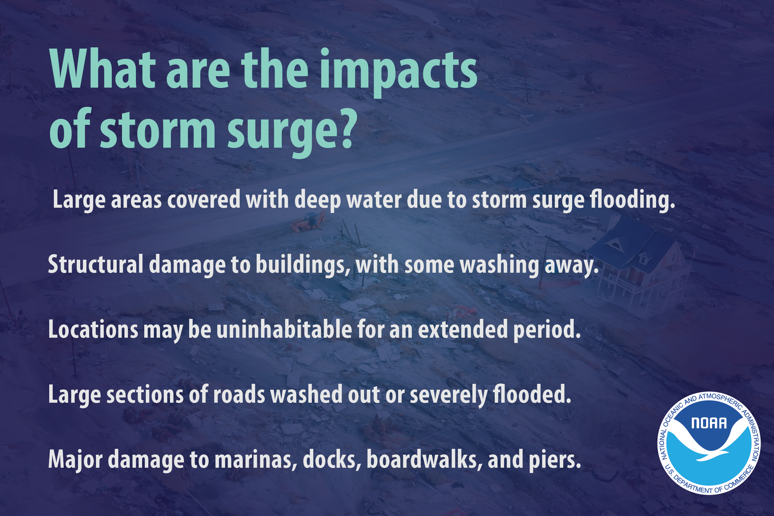
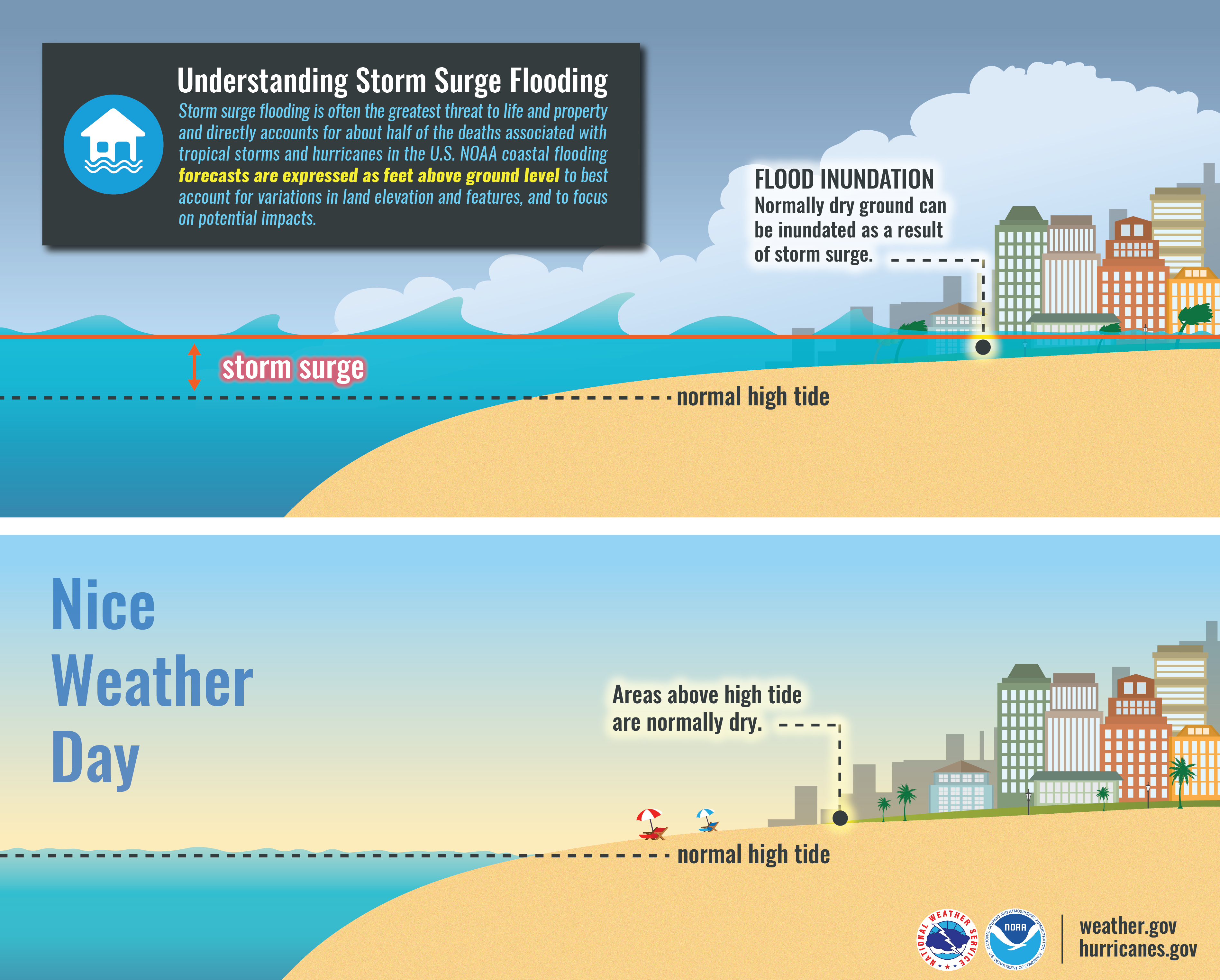
Storm Surge
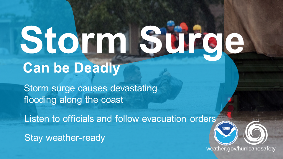
One of the greatest potentials for loss of life related to a hurricane is from the storm surge. Storm surge is simply water that is pushed toward the shore by the force of winds swirling around the storm. This advancing surge combines with the normal tides to create the hurricane storm tide, which can increase the mean water level to heights impacting roads, homes and other critical infrastructure. The shape and orientation of our coastline put's us at risk for storm surge. Most recently we saw devastating storm surge from both hurricanes Florence and Dorian.
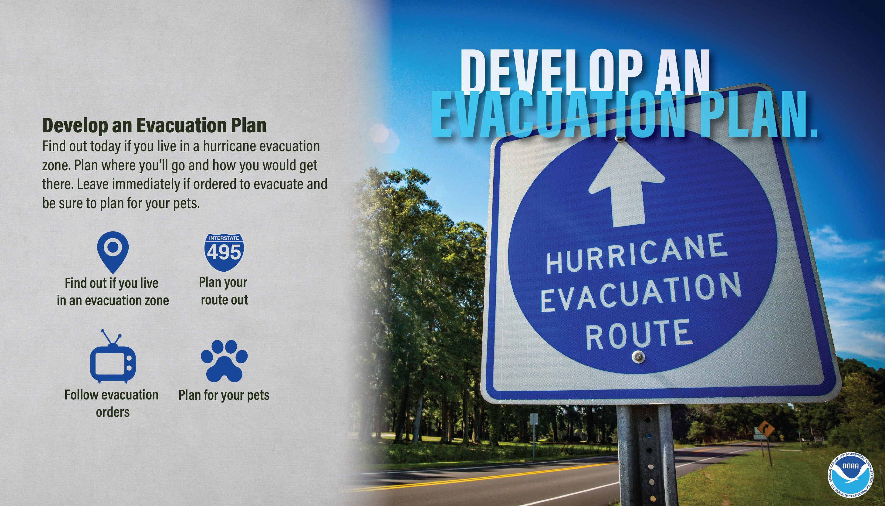
Develop An Evacuation Plan
The first thing you need to do is find out if you live in a storm surge hurricane evacuation zone or if you're in a home that would be unsafe during a hurricane. If you are, figure out where you'd go and how you'd get there if told to evacuate. You do not need to travel hundreds of miles. Identify someone, perhaps a friend or relative who doesn't live in a zone or unsafe home, and work it out with them to use their home as your evacuation destination. If possible, have multiple options and be sure to account for your pets and put the plan in writing.
Know Your Zone
Know Your Zone is a cooperative effort of North Carolina Emergency Management and county emergency management partners in coastal counties. After being piloted during the 2019 hurricane season, state and county emergency emergency management will partner to officially launch the Know Your Zone initiative prior to the peak of the 2020 season.
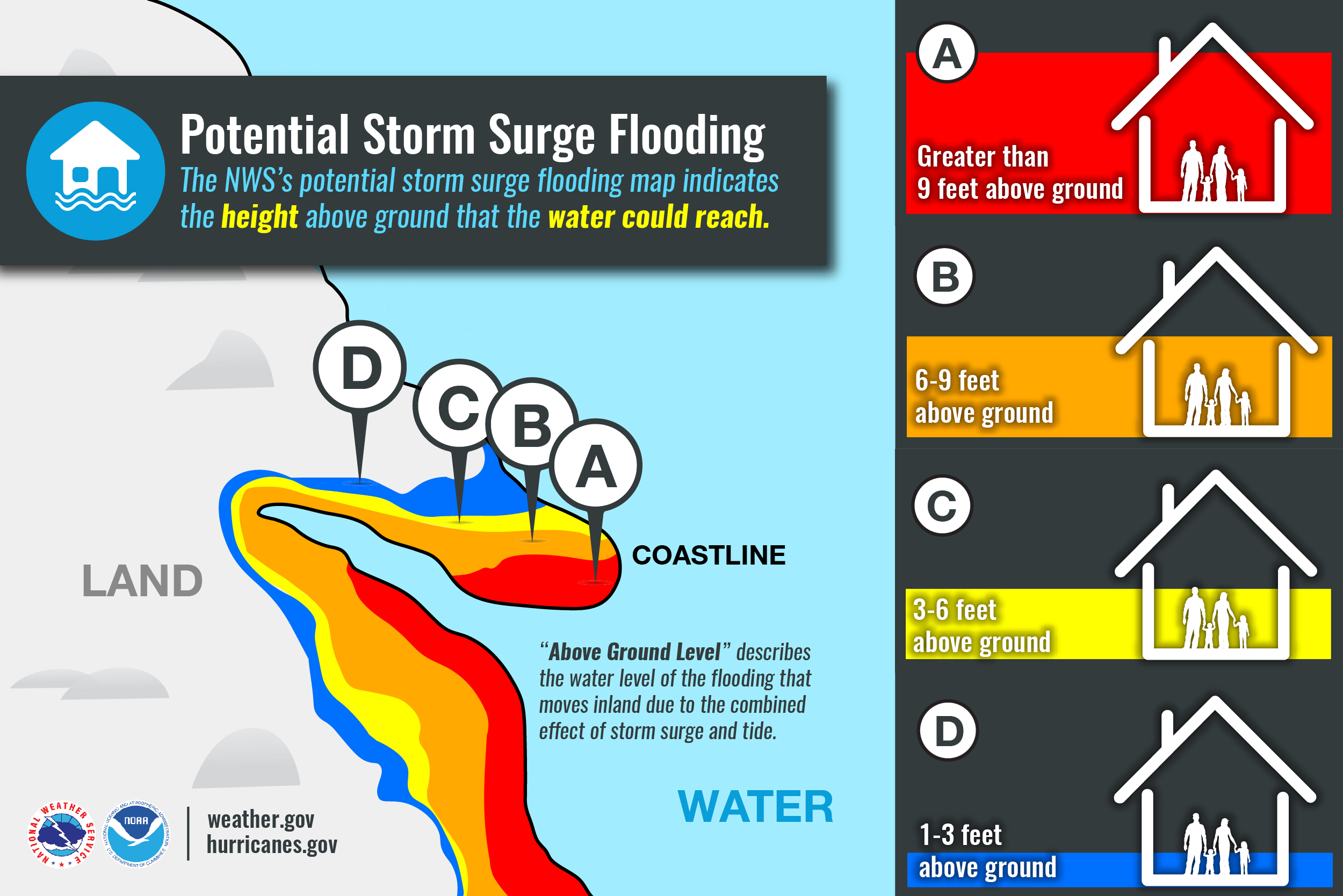
North Carolina Know Your Zone is a tiered evacuation system that highlights areas most vulnerable to impacts from hurricanes, tropical storms, and other hazards. If it becomes necessary, local officials will order evacuations using pre-determined zones created by coastal counties. The Know Your Zone lookup tool is a new color-coded interactive map you can use to determine the evacuation zone where you live, work, or are visiting based upon your street address.
Evacuation zones highlight areas most at risk to storm surge and flooding. Local officials will determine which areas should be evacuated. Areas in Zone A will typically be evacuated first, followed by areas in Zone B, etc. While all zones won’t be evacuated in every event, emergency managers will work with local media and use other outreach tools to notify residents and visitors of impacted zones and evacuation instructions.
Please take some time this week to read more about Know Your Zone in preparation for this launch and coming hurricane season. To access the lookup tool and other resources, please visit the website by clicking on the image below.

Storm Surge Infographics
 |
 |
 |
|
 |
 |
View Video For More
Tuesday
Assemble Disaster Supplies/High Winds
Public Information Statement Day 3 (good for more detailed text)

Assemble Disaster Supplies
You’re going to need supplies not just to get through the storm but for the potentially lengthy and unpleasant aftermath. Have enough non-perishable food, water and medicine to last each person in your family a minimum of one week. Electricity and water could be out for at least that long. You’ll need extra cash, a 30-day supply of medicines, a battery-powered radio and flashlights. Many of us have cell phones, and they all run on batteries. You’re going to need a portable, crank or solar powered USB charger. Before the storm, be sure to fill up your car or a gas can. If the power goes out, you will be unable to pump gas. To learn more about what to include in your disaster supply kit, please visit http://flash.org.
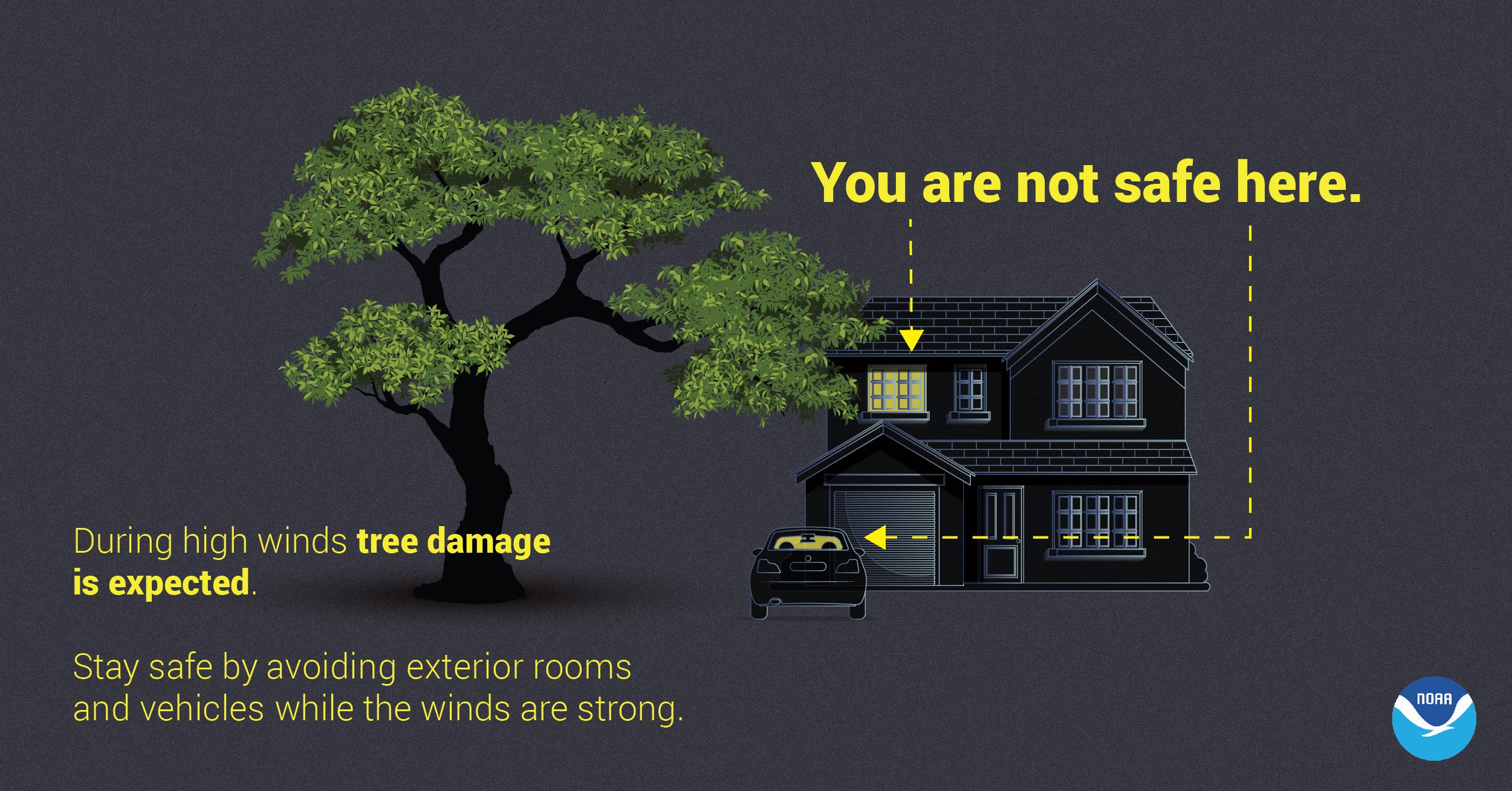
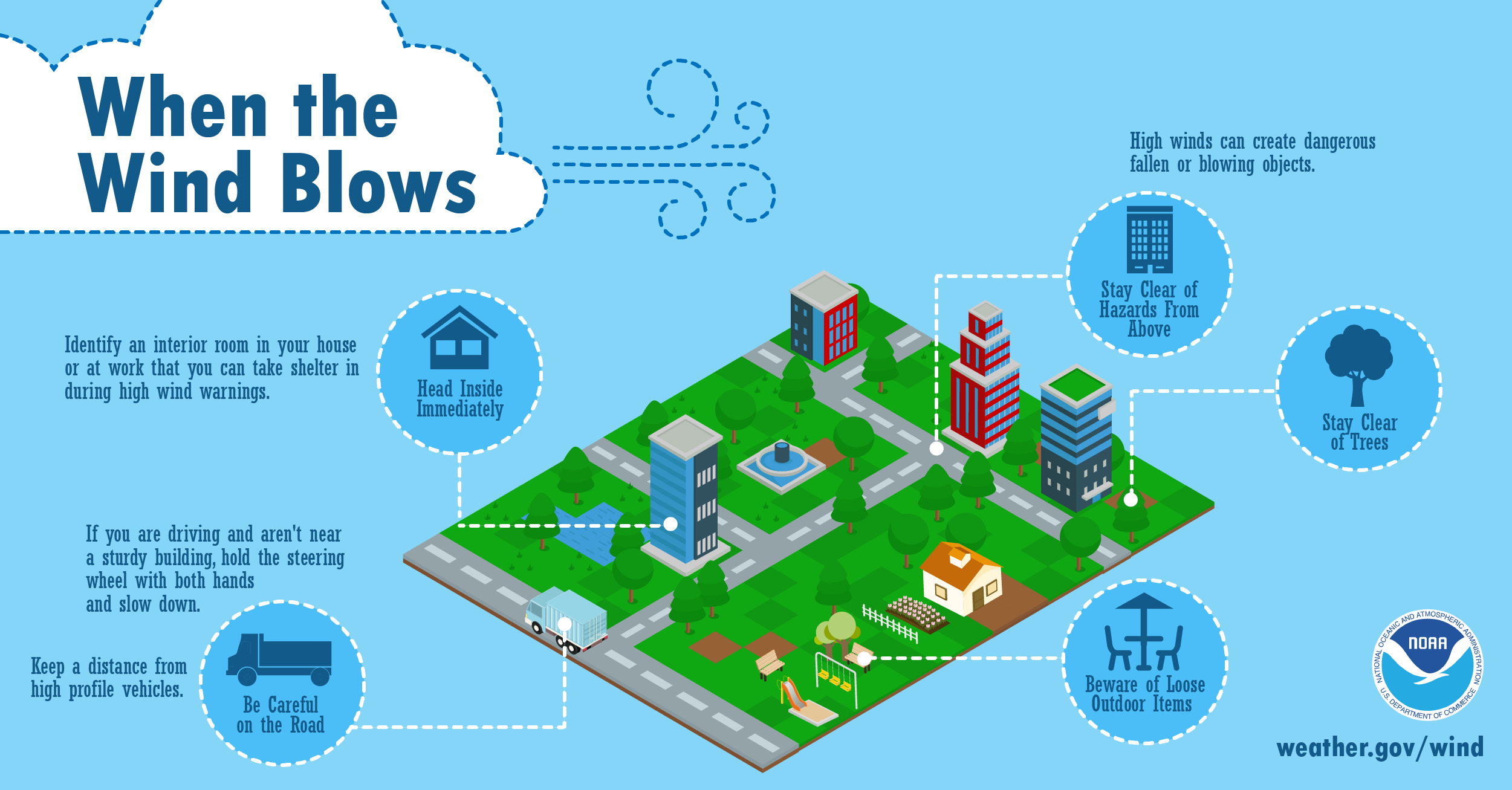
High Winds
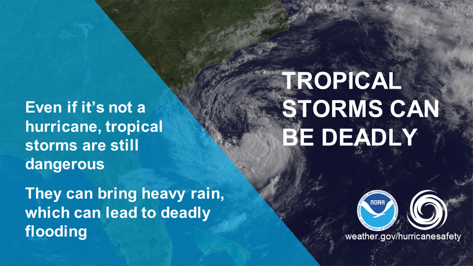
Keep in mind that even tropical storm force winds (39 to 73 mph) are capable of tossing around debris and causing damage. For this reason, you should seek shelter from the wind in a sturdy building as the hurricane moves inland and before the onset of tropical storm force winds. Tropical storm force winds usually strike hours ahead of the actual hurricane’s eye. For this reason many emergency officials typically have evacuations completed and personnel sheltered before the onset of tropical storm force winds.
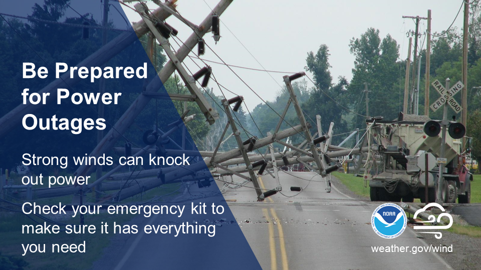
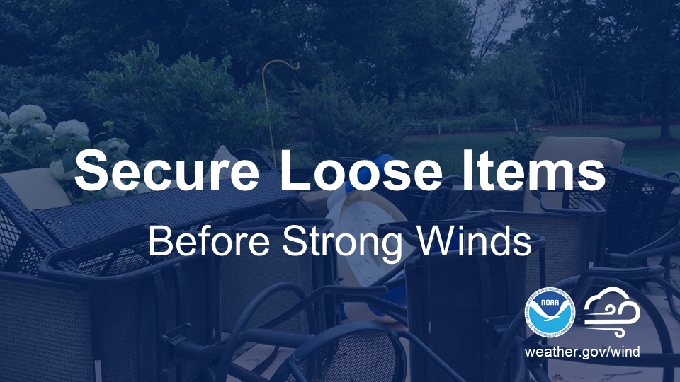
Hurricane force winds can easily destroy poorly constructed buildings and mobile homes. Debris such as signs, roofing material, and items left outside become flying missiles in high wind. Falling trees cause extensive damage to power lines, towers and underground water lines. This can cause extended disruptions of utility services. Damaging hurricane force winds can be just as devastating as tornadoes.
High Wind Infographics
 |
 |
 |
 |
 |
 |
View Video For More
Wednesday
Get an Insurance Checkup/Inland Flooding
Public Information Statement Day 4 (good for more detailed text)

|
|
|
|
|
Get An Insurance Checkup
Call your insurance company or agent and ask for an insurance check-up to make sure you have enough homeowners insurance to repair or even replace your home. Don’t forget coverage for your car or boat. Remember, standard homeowners insurance doesn’t cover flooding. Whether you’re a homeowner or renter, you’ll need a separate policy for it, and it’s available through your company, agent or the National Flood Insurance Program at www.floodsmart.gov. Act now as flood insurance requires a 30-day waiting period. Finally, know where your insurance documents and contact information are located, and be sure to take them with you if you have to evacuate.
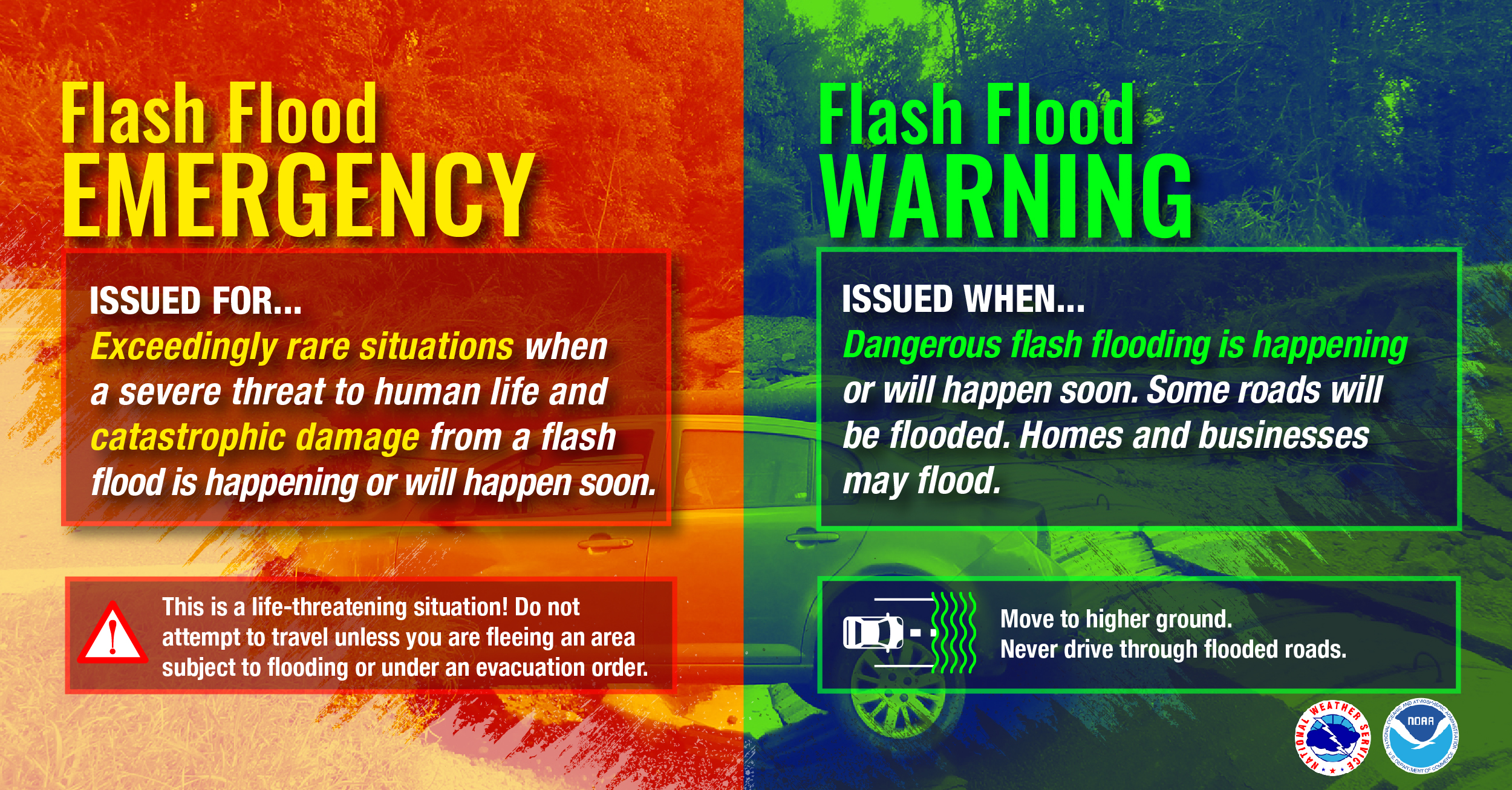
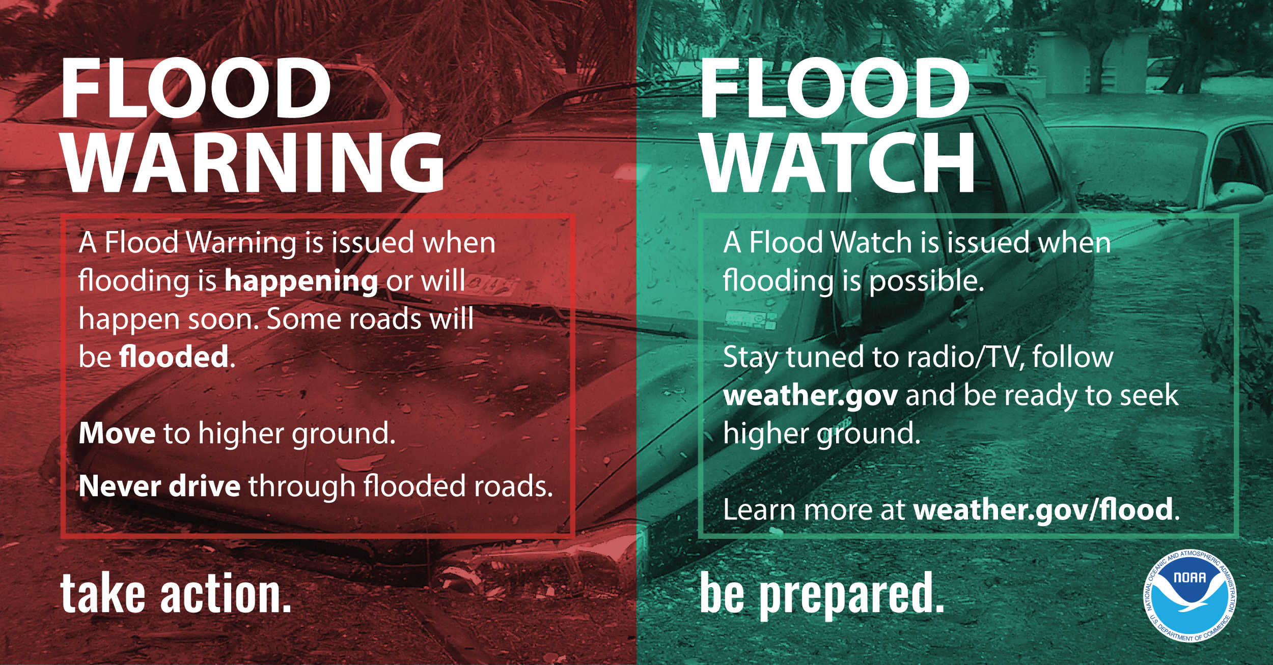
Inland Flooding
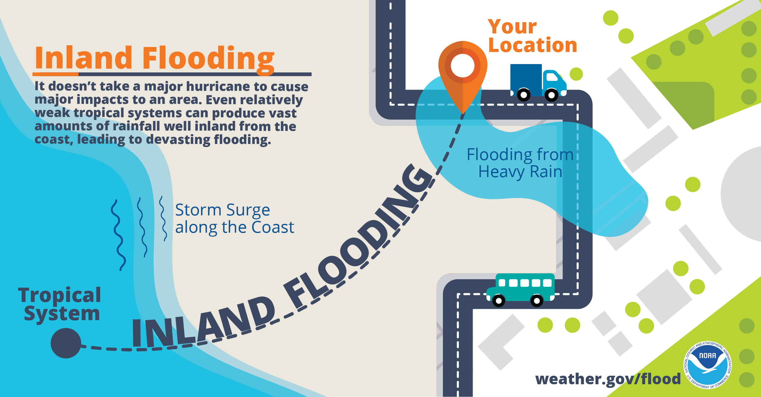
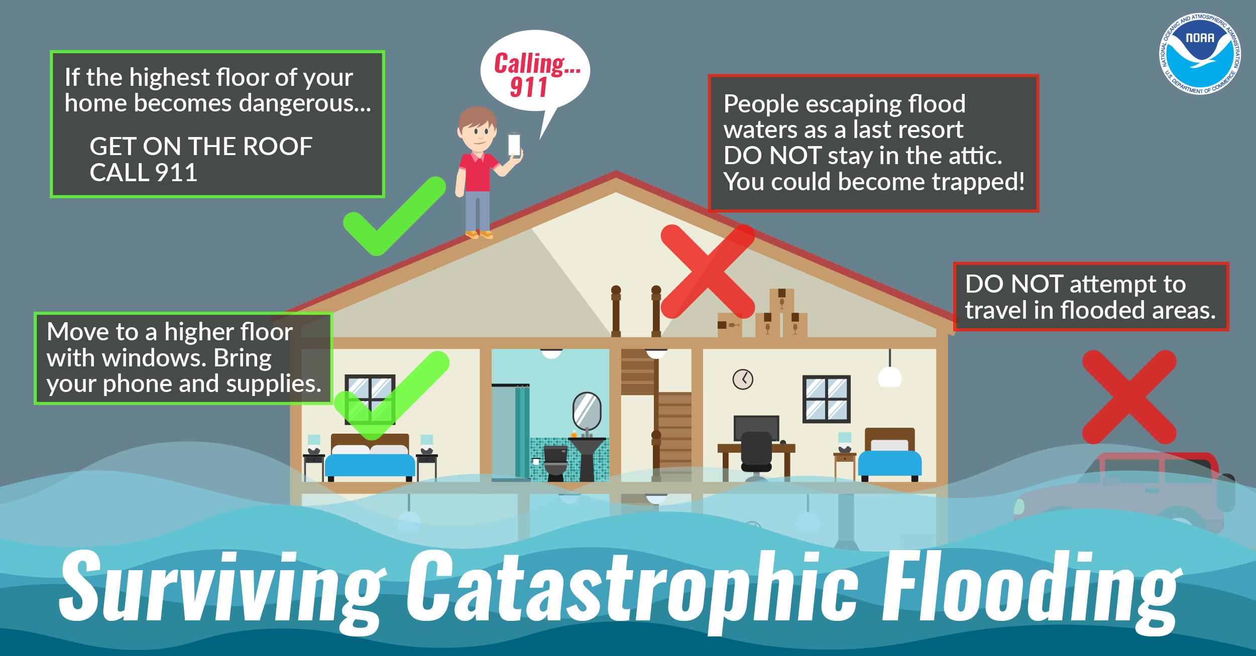
Inland flooding is the most deadly and serious threat hurricanes bring to inland areas of North Carolina. Hurricane Matthew in October 2016 generated record flooding across much of the coastal plain of North Carolina, claimed 28 lives, and left thousands homeless and entire towns under water. More recently, Hurricane Florence once again produced devastating inland flooding, and resulted in 11 flood-related deaths in North Carolina. Overall, most hurricane deaths over the past 30 years have been the result of flooding, many of which have occurred in automobiles as people attempt to drive through flooded areas where water covers the road. It is important to realize the amount of rain a tropical system produces is not related to the intensity of the wind. Weak hurricanes and even tropical storms have caused disastrous floods throughout history.
So what can you do? Anytime a hurricane or tropical storm threatens, think flooding. It is very important to determine if you live in an area at risk of flooding. If your yard or nearby roads around your home flood during ordinary thunderstorms, then you are at serious risk of flooding from torrential tropical rainfall. Those living near creeks, streams and drainage ditches should also closely watch water levels. Remember, extreme rainfall events bring extreme flooding typically not experienced in the past. During extreme events even those area which normally do not flood are at risk.
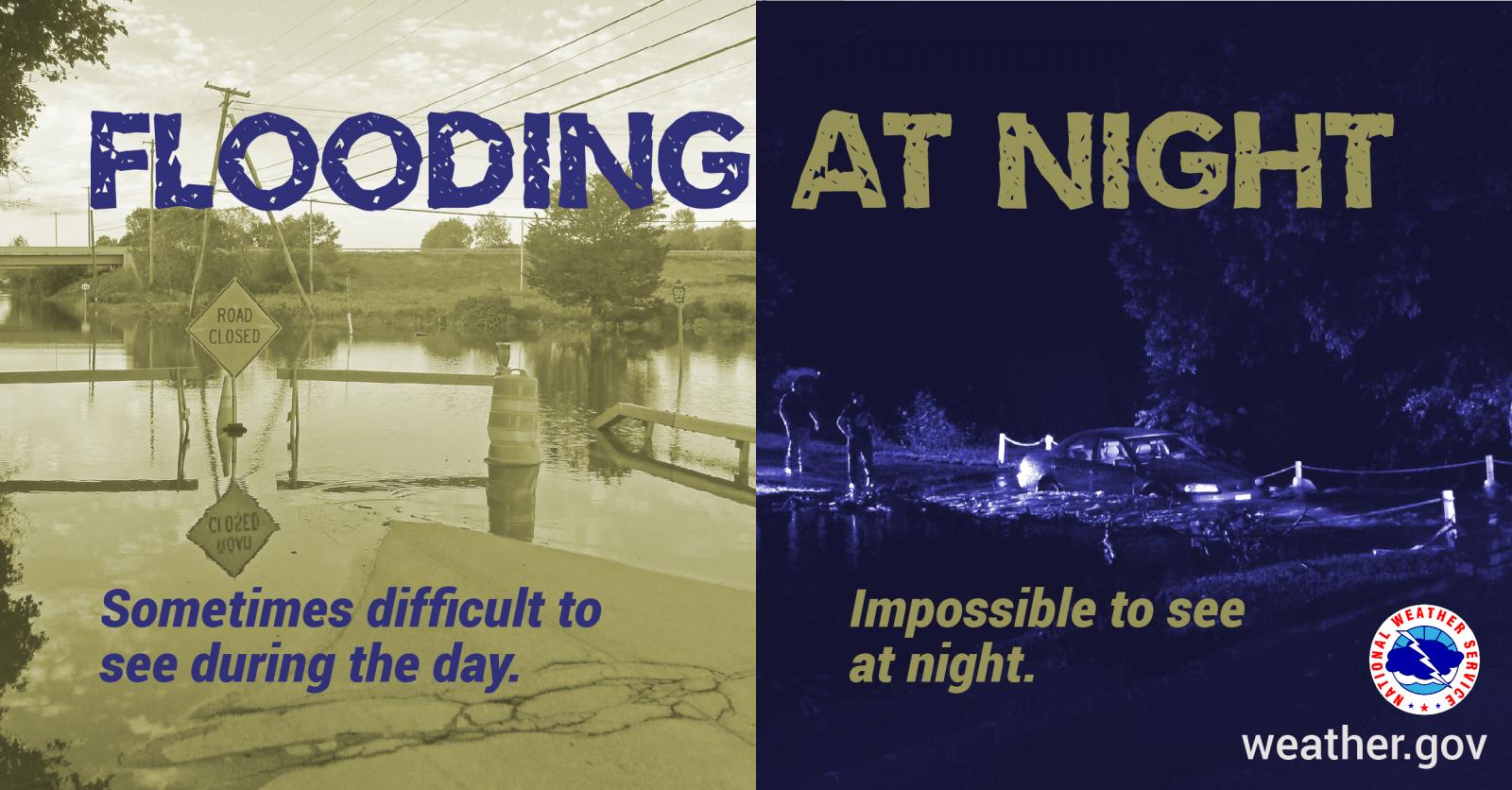
Always stay aware of road conditions and make sure your escape route is not becoming flooded by heavy rain. Never attempt to cross flowing water; instead, remember to turn around, don't drown. The reason that so many people drown during flooding is because few of them realize the incredible power of water. A mere six inches of fast-moving flood water can knock over an adult. It takes only two feet of rushing water to carry away most vehicles. This includes pickups and SUVs. Never allow children to play near streams, creeks or drainage ditches. As rain water runs off, streams, creeks, and ditches fill with running water that can easily sweep a child away.
Inland Flooding Infographics
 |
 |
 |
 |
 |
 |
View Video For More
Thursday
Strengthen Your Home/Tornadoes
Public Information Statement Day 5 (good for more detailed text)

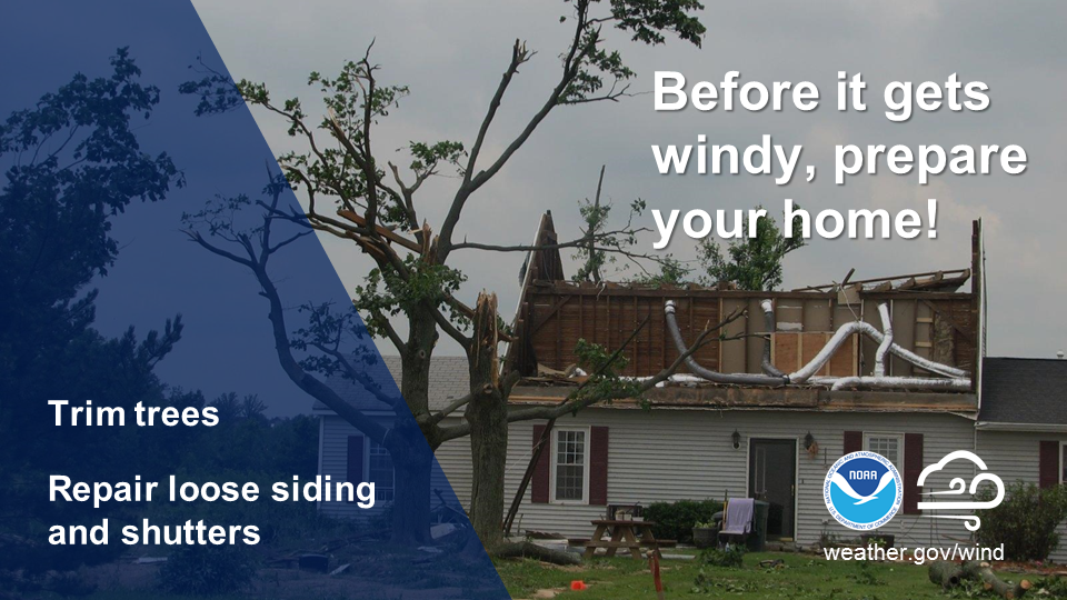
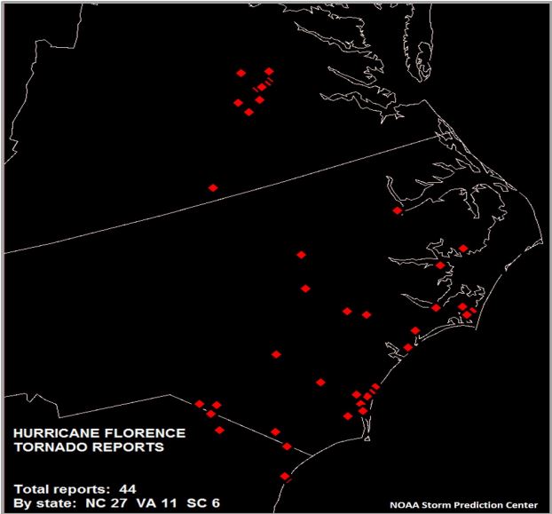
Strengthening Your Home
If you plan to ride out the storm in your home, make sure it is in good repair and up to local hurricane building code specifications. Many of these retrofits do not cost much or take as long to do as you may think. Have the proper plywood, steel or aluminum panels to board up the windows and doors. Remember, the garage door is the most vulnerable part of the home, so it must be able to withstand the winds.
Here are some tips for preparing and strengthening your home for tropical storms and hurricanes:
Tornadoes
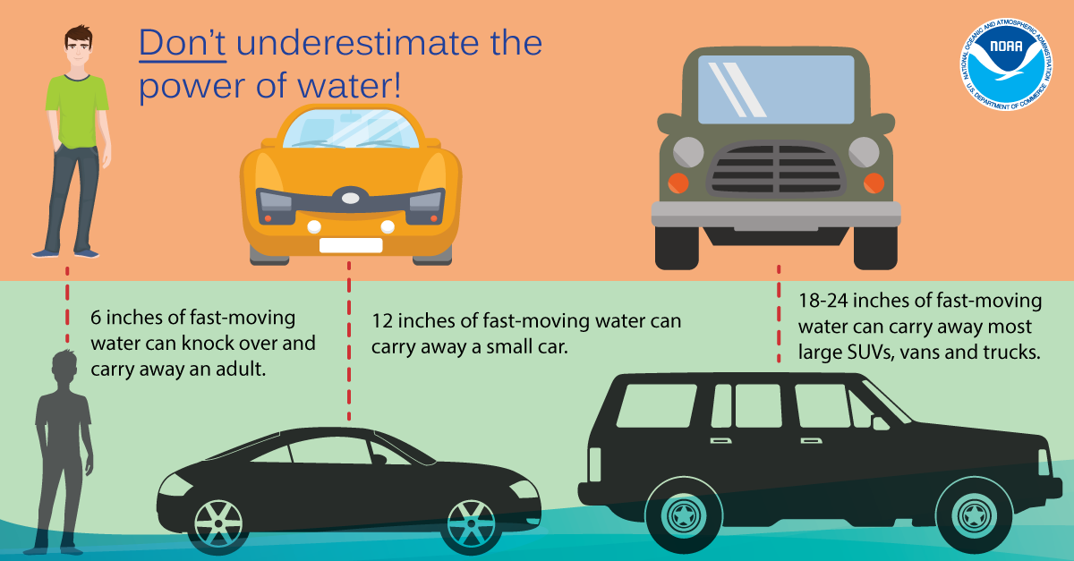
ANY tropical system is capable of producing tornadoes! Tropical tornadoes are often short lived but they can produced enhanced areas of damage. Sometimes these tornadoes can occur in the outer rain bands, well ahead of the center of the storm. In 2019 Hurricane Dorian produced an EF-2 tornado in Emerald Isle, NC with estimated winds of 115 MPH. In 2018, Hurricane Florence produced 27 tornadoes in North Carolina! To prepare for the possibility of tornadoes it's important to have multiple ways to receive warnings, so you can seek shelter quickly if a warning is issued for your area.
Hurricane Florence Tornado Reports
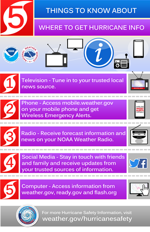
Identify Your Trusted Sources of Information
​
NOAA's National Hurricane Center is your official source for hurricane forecasts and the issuance of hurricane watches and warnings. Your local NOAA National Weather Service forecast office provides information regarding the expected impacts from the storm for your area. Emergency managers will make the decisions regarding evacuations.
Organizations such as FLASH make disaster safety recommendations. And the media outlets will broadcast this information to you. All work together to be your trusted sources, especially for those less able to take care of themselves.
Here are some additional suggestions regarding where to get trusted tropical storm and hurricane information:
 |
 |
 |
View Video For More
Friday
Help Your Neighbor/Rip Currents
Public Information Statement Day 6 (good for more detailed text)

Help Your Neighbor
Comprehensive preparedness requires the whole community to participate in hurricane preparedness. That said, many people, especially senior citizens, rely on the assistance of neighbors before and after hurricanes. Did you know that forty-six percent of individuals expect to rely a great deal on people in their neighborhood for assistance within the first 72 hours after a disaster? You can make a difference by getting involved in your community and acting today to prepare for the upcoming hurricane season!
The basic steps for helping your neighbor are easy. This week, be sure to help your neighbors collect the supplies they’ll need before the storm. Then as storms approach, assist them with evacuation orders if ordered to do so. Then after the storm is over, be sure to check on your neighbors after its safe for you to head outside.
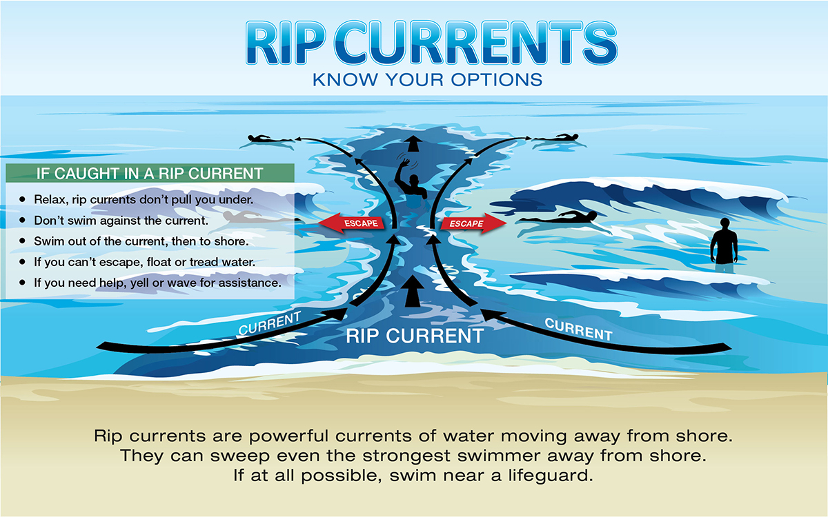
Rip Currents
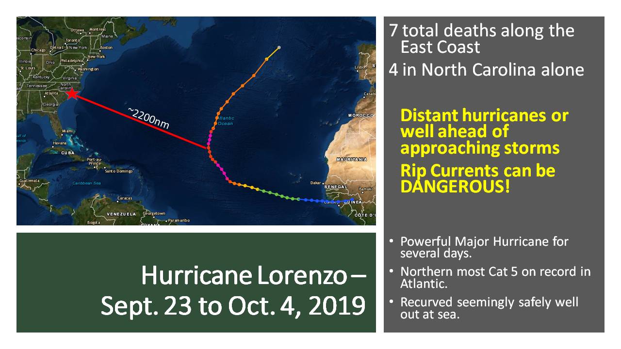
Even when hurricanes stay out at sea, the North Carolina coast can still be impacted by large swells and deadly rip currents, thus making it important to stay aware of the tropics and weather forecasts all throughout the hurricane season. Rip currents are channelized currents of water flowing away from shore at surf beaches. Rip currents are quite common and can be found on many surf beaches every day. They typically form at breaks in sandbars, and also near structures such as jetties and piers. While the risk of rip currents occurring along the North Carolina beaches increases when a tropical cyclone is out in the Atlantic, the risk increases even more so when a tropical cyclone is moving toward the North Carolina coast, especially when the storm is a day or two away from making landfall along the Carolina coast.
Rip currents are dangerous because they can pull people away from shore. Rip current speeds can vary from moment to moment and can quickly increase to become dangerous to anyone entering the surf. Rip currents can sweep even the strongest swimmer out to sea. Some clues that a rip current may be present include a channel of churning, choppy water, a difference in water color, a break in the incoming wave pattern, and a line of foam, seaweed or debris moving seaward.
If you find yourself caught in a rip current, stay calm and don’t fight the current. Escape the current by swimming in a direction following the shoreline. When free of the current, swim at an angle—away from the current—toward shore. If you are unable to escape by swimming, float or tread water. When the current weakens, swim at an angle away from the current toward shore. If at any time you feel you will be unable to reach shore, draw attention to yourself: face the shore, call or wave for help. Also, don’t become a victim while trying to help someone else! Many people have died in efforts to rescue rip current victims. Instead, get help from a lifeguard. If a lifeguard is not present, yell instructions on how to escape. If possible, throw the rip current victim something that floats. Call 9-1-1 for further assistance.
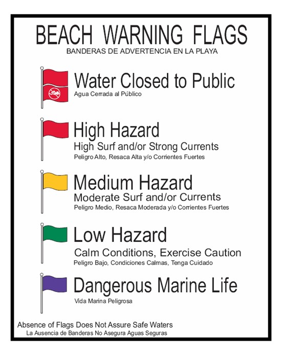
Hurricane Lorenzo
Rip Current Safety
Beach Flags
View Video For More
Saturday
Complete a Written Plan
Public Information Statement Day 7 (good for more detailed text)
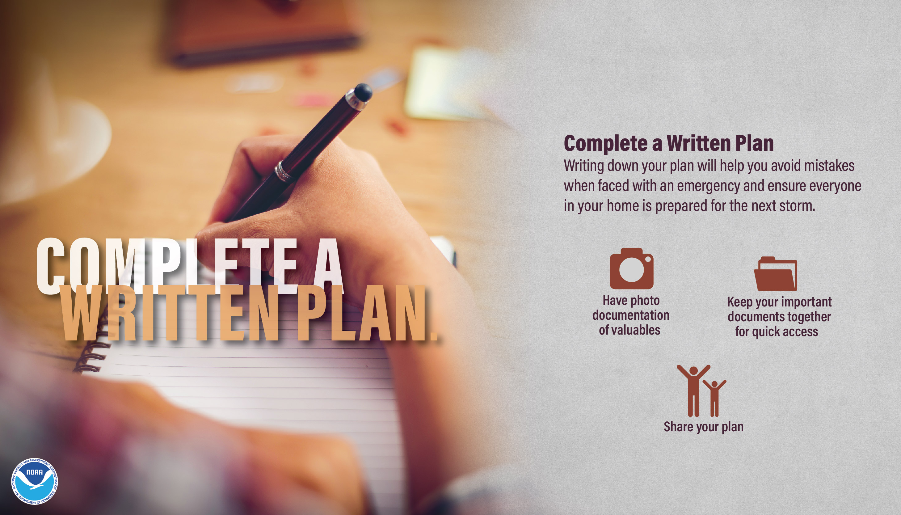
Complete Your Written Plan
The time to prepare for a hurricane is before the season begins, when you have the time and are not under pressure. If you wait until a hurricane is on your doorstep, the odds are that you will be under duress and will make the wrong decisions. Take the time now to write down your hurricane plan. Know where you will ride out the storm and get your supplies now. You don’t want to be standing in long lines when a hurricane warning is issued. Those supplies that you need will probably be sold out by the time you reach the front of the line. Being prepared, before a hurricane threatens, makes you resilient to the hurricane impacts of wind and water. It will mean the difference between your being a hurricane victim and a hurricane survivor.
Here are some things to know about completing a written hurricane plan:
To make developing your family emergency plan easy, be sure to download a free template that is available online at http://readync.org.
Find us on social media:
You can also contact:
Nick Petro (Nicholas.Petro@noaa.gov) for additional information about Hurricane Preparedness.


 Youtube
 Heat Safety
 Statewide Maps
 Forecaster Discussion
 Current Condtions