There were a total of 12 tornadoes in the state of North Carolina on Friday, April 19, 2019, which included:
The following list provides details of each of the 12 tornadoes that occurred in the state of North Carolina on April 19, 2019. Each track image below is click-able to magnify the image.
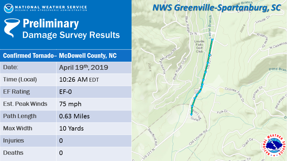 |
| A McDowell County Emergency Management damage survey, in coordination the NWS, determined that a small EF0 tornado touched down along US 221 N in Ashford, traveling just over half a mile. Most of the damage consisted of limbs down with some trees uprooted, but some minor structural damage was observed, including to shingles of the Inn at Blue Ridge and some metal skirting around the base of a mobile home. Some small outbuildings also sustained damage. |
 |
|
A tornado briefly touched down in the Robbins area of northwest Moore County. Damage consisted of numerous snapped and uprooted trees and subsequent damage to the roofs of several homes that the trees fell on. Based on the damage to the trees, this tornado was rated an ef-1 with maximum wind speeds of 90 to 100 mph. |
 |
|
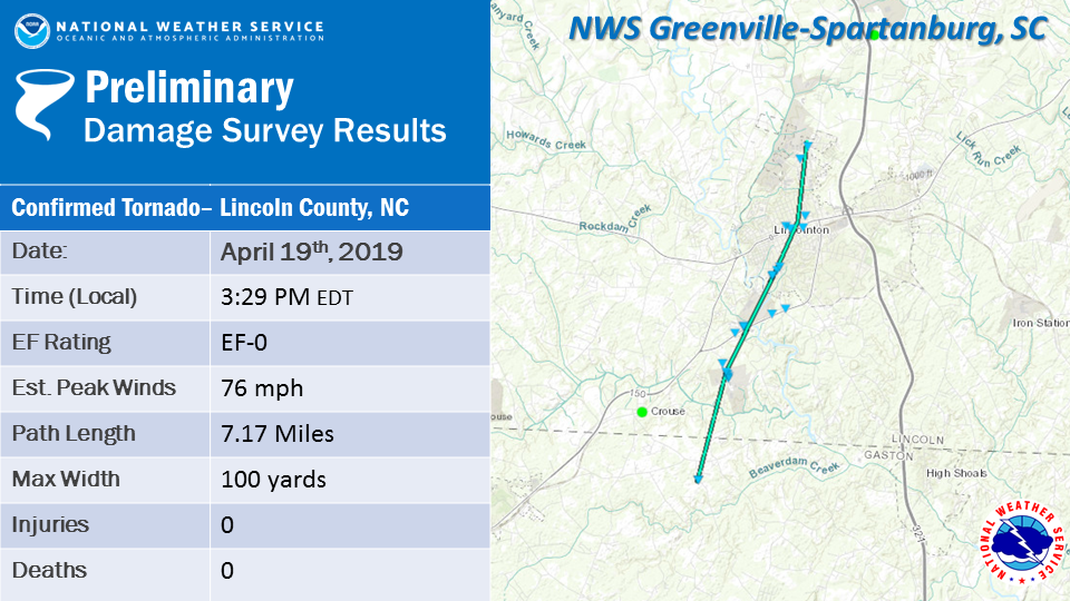
The NWS damage survey has concluded that a weak tornado touched down over northern Gaston County, North Carolina, and moved north- northeast into Lincoln County, eventually moving across the city of Lincolnton, before lifting north of Lincolnton. At the beginning of the damage path, one person was injured when a large tree fell onto a house. Most of the damage along the path of the tornado was limited to trees, some uprooted, and others with large limbs snapped. More information may be given when the survey team returns from the field. |
 |
|
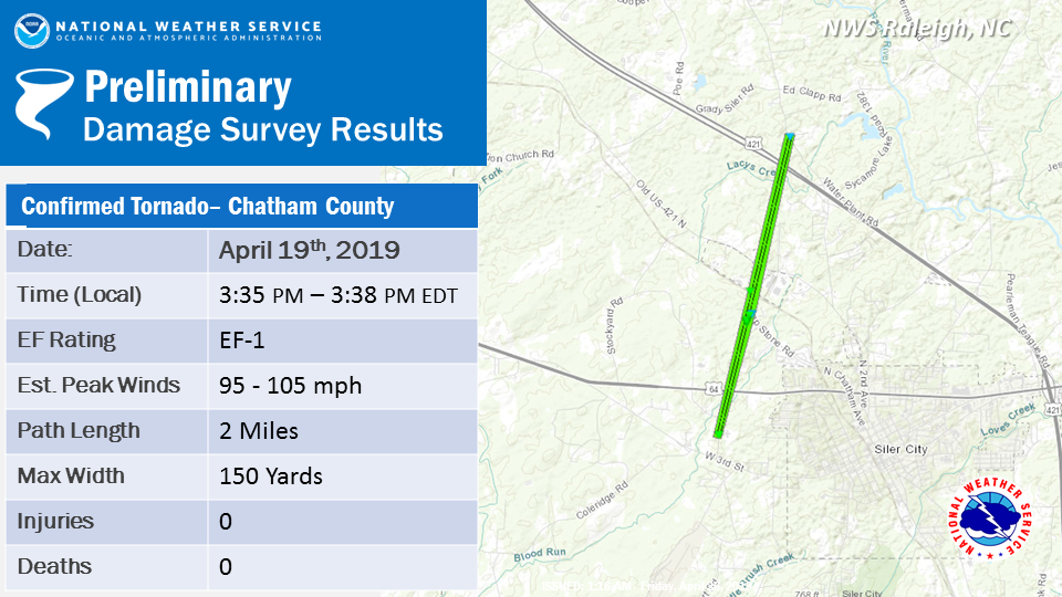
A tornado briefly touched down in the Siler City area of Chatham County. Damage consisted of numerous snapped and uprooted trees, downed power poles and power lines, and damage to the roof covering of several homes. |
 |
|
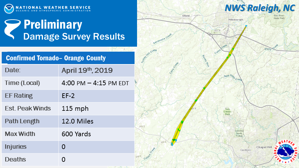
A tornado initially touched down in the White Cross area and Leslie Drive area of southwest Orange County. Considerable tree damage occurred in this area, including the snapping and splitting of healthy large-trunk trees. Subsequent damage to vehicles and homes occurred as the trees fell. Given the magnitude and nature of the damage, wind speeds were estimated at 110 mph. The tornado then tracked north-northeast eventually crossing Dodsons Cross Road, Dairlyland Road, Arthur Minnis Road, and Borland Roads, all while producing similar tree damage. The tornado finally began to lift and/or dissipate near Hillsborough just north of I-40 near exit 261, but not before producing considering damage to several homes just south of exit 261. The roof and several exterior walls of one home were completely destroyed. Damage at this location was estimated at 115 mph, making this tornado a low-end EF-2 on the EF scale. |
 |
| The NWS Damage Survey has concluded that a tornado touched down in eastern Alexander County, North Carolina, north of Hiddenite. The path of the tornado was short, but wind speed was strong enough to peel part of a metal roof off a barn and loft the metal pieces some distance. Other damage was limited to trees. More information may be added when the survey team returns from the field. |
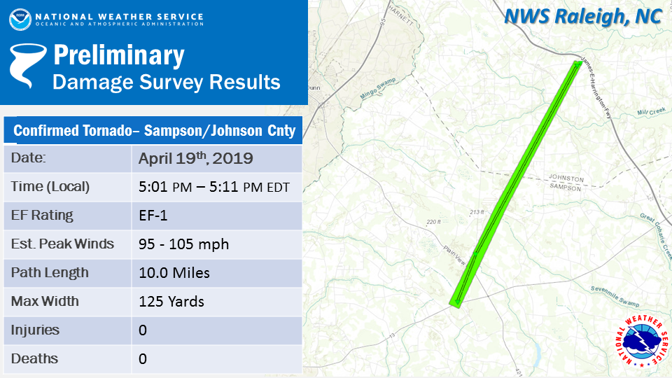 |
| A tornado touched down in the Spivey’s Corner area of northwest Sampson County. Damage there consisted of numerous snapped and uprooted trees, downed power poles and power lines, tossed outdoor furniture, and minor damage to the roof of at least one home. The tornado then oscillated up and down for about 8 miles, resulting in minor tree damage when briefly touching down. The tornado finally touched down one last time in the Meadow area of southern Johnston County, where it did considerable roof and window damage to two homes, snapped and uprooted numerous trees, and blew over several grain silos. Based on the damage to the homes and trees, this tornado was rated an ef-1 with maximum wind speeds of 95 to 105 mph. |
 |
|
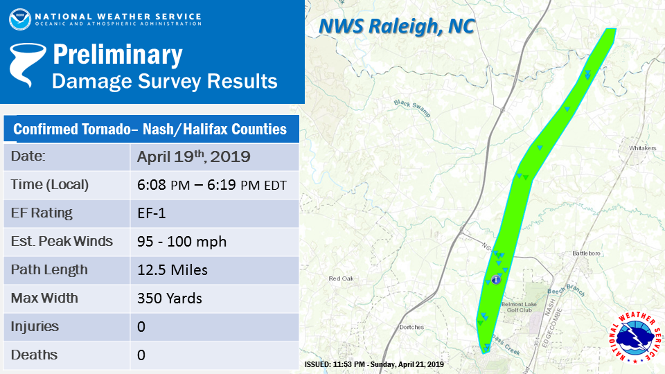
A tornado touched down just northwest of the City of Rocky Mount along the Thomas A Betts Parkway. The tornado continued north, producing intermittent tree damage in the form of snapped and uprooted hardwood trees, sliding just west of the Belmont Lake Golf course. The tornado strengthened and widened to a peak width of roughly 350 yards as it intersected NC-4 just West of Battleboro, producing a rather widespread swath of snapped and uprooted trees along with EF-1 damage to several farm outbuildings and one residence which lost considerable roof sheeting. A Tornado Debris Signature (TDS) from KRAX became rather apparent at this point. The storm continued north before taking a quick jog to the northeast as it began to weaken just west of Whitakers. The tornado remained on the ground producing intermittent tree damage as it passed over Fishing Creek, entering into Halifax County before lifting roughly a mile into the county just north of Low Ground Road. While tornado damage wasn`t observed north of this point, debris continued to be deposited several miles north of the damage path. |
 |
|
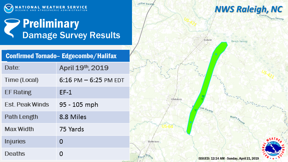
After receiving additional damage reports near the Sunnyside community, the tornado that was confirmed 3 SSE of Whitakers has been extended further to the southwest. The tornado now will start 2 ESE of Battleboro where multiple trees were snapped and uprooted. The tornado then lifted and briefly touched down just southwest of Whitakers, not far from the Swift Creek crossing along Seven Bridges Road. The tornado continued north northeastward for a total path length of 10.57 miles, causing primarily vegetation damage in the form of intermittent uprooted and snapped trees. The tornado reached its max intensity just prior to crossing Speights Chapel Road where it directly hit a fifty year old single-wide trailer home, completely destroying it, and lofting debris from the structure for several hundred yards downstream. The home was unoccupied at the time, and the neighboring structures of similar build only received minor structural damage. The tornado continued northeastward, damaging some farm outbuildings on the north side of NC 33 before it ventured into Halifax County, only causing intermittent tree damage as it ventured into marshlands. The tornado lifted and dissipated rapidly after approaching Beech Swamp. A Tornado Debris Signature (TDS) was clearly evident from the KRAX Weather Radar in Johnson County, NC, primarily after the tornado hit the single-wide home structure. |
 |
| The tornado touched down 4 miles west of Gaston, NC in western Northampton County, just north of Lake Gaston. The tornado tracked north and crossed Highway 46 near Cherry Tree Road before lifting. Damage consisted of trees being uprooted and snapped. |
 |
|
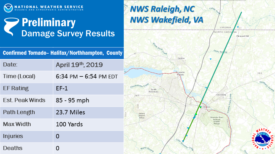
NOTE: This tornado remained on the ground as it crossed the Roanoke River into Northampton County and eventually into Virginia. Thus, there are two portions of this survey - one from NWS Raleigh and the other from NWS Wakefield. NWS Raleigh portion of the survey: A tornado touched down southwest of Weldon, NC on the afternoon of April 19th, 2019. The damage path began just north of Little Quankey Creek, with the primary indicators being intermittent uprooted and snapped hardwood trees as the storm progressed northeast. The tornado remained on the ground for four minutes and a little over five miles, reaching its peak intensity and width as it impacted a small community of single family homes just west of the high school in South Weldon. Several of these structures suffered minor damage to their roof and siding, and many trees and small bushes were blown over or snapped. The tornado continued north causing intermittent tree and minor structural damage through the western fringes of Weldon before it crossed the Roanoke River into Northampton County. NWS Wakefield portion of the survey: The tornado crossed the Roanoke River into Northampton County, NC near Garysburg and moved north-northeast across NC Highway 46 where it snapped and uprooted several trees. The tornado continued tracking across rural portions of Northampton County, NC before crossing into Greensville County, VA near Skippers Road where additional trees were snapped. The tornado then briefly lifted while shifting its track slightly east and touching down again near Caney Swamp south of Taylor`s Mill Road. From here, the tornado continued northeast and caused EF-1 damage to numerous trees along Low Ground Road, before reaching Highway 58 in southwestern Southampton County, VA and then lifting again. |
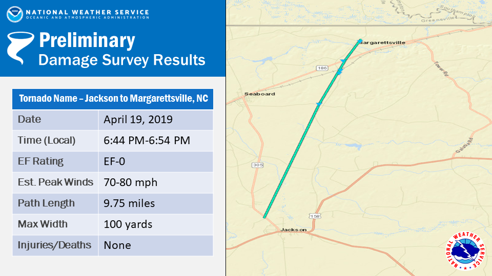 |
| The tornado touched down approximately 1 mile northwest of the town of Jackson in Northampton County, NC. The tornado tracked north-northeast over rural portions of Northampton County, NC before finally lifting just west of Margarettsville, NC in Northampton County. The tornado mostly uprooted and snapped trees along its path. |


 Heat Safety
 Statewide Maps
 Forecaster Discussion
 Current Condtions