Review of Nov 28-29 Thanksgiving Holiday Weather Event
By NWS Phoenix -- last updated at 1 AM on 8 January 2020
Overview: An unusually strong low pressure developed just off the coast of Oregon on late Monday Nov 26 into Tuesday Nov 27, 2019 with surface pressure dropping an impressive 43 millibars (mb) in 24 hrs. This low pressure system was so strong that it unofficially broke a record for low surface pressure for California as Crescent City, California measured a surface pressure of 973.4mb (28.69”) Monday evening. This was enough to produce sustained winds of 85 mph with a gust to 106 mph Tuesday afternoon at Cape Blanco, Oregon.
Even though the storm system would weaken Wednesday into Thursday, it would eventually bring a very strong cold front through southern California during the afternoon hours of Thanksgiving Day and through the Phoenix area during the early morning hours of Friday Nov 29.
The combination of ample moisture ahead of the cold front, very strong low and mid level winds, and the cold frontal forcing mechanism brought heavy rainfall and localized flooding to much of southern Arizona as well as damaging winds and 4 confirmed tornadoes in Phoenix (see link for storm reports).
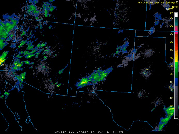
Regional Radar Composite Reflectivity 3PM Nov 28 to 9AM Nov 29 2019. Click on image for a loop of the full event.
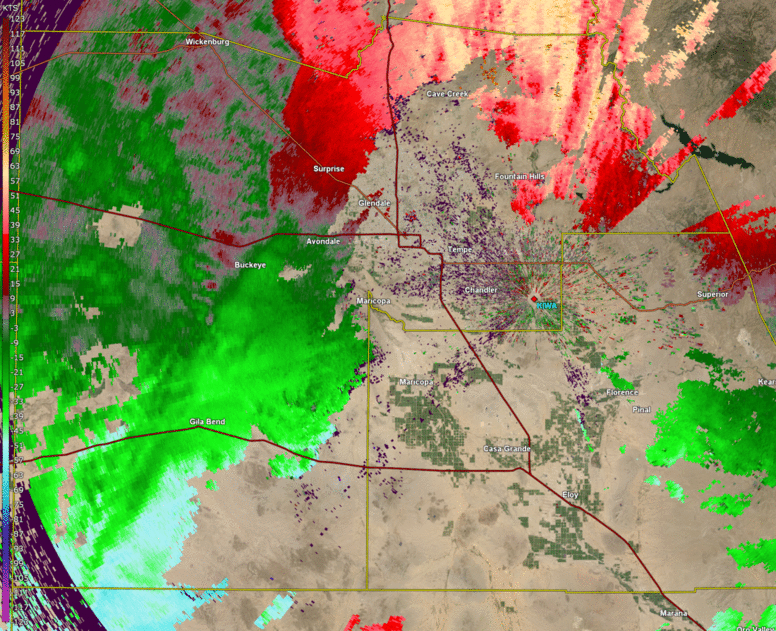
The most unusual aspect of this event was likely the strong squall line of thunderstorms that first developed over the western portion of the Phoenix area between 230-300 AM early Friday morning before sweeping through the rest of the Phoenix metro bringing three confirmed tornadoes, damaging winds, and heavy rainfall.
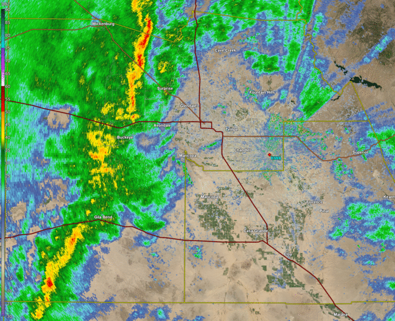
Phoenix Radar Base Reflectivity 245AM to 545AM Nov 29 2019. Click on image for a loop.
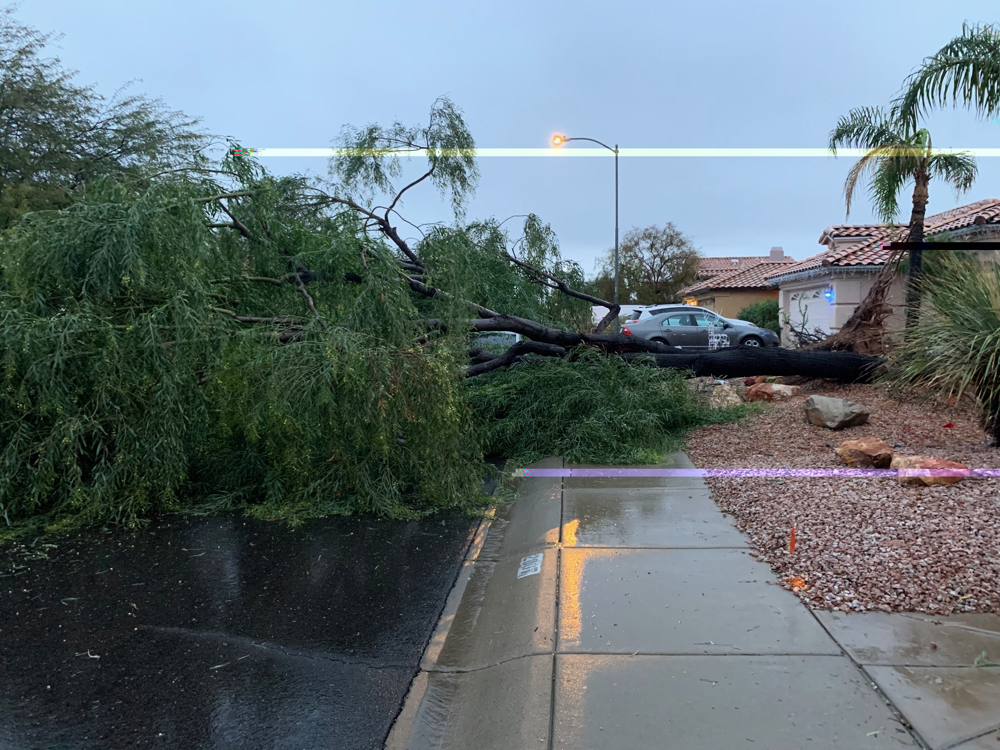
Phoenix EF0 & EF1 Tornadoes: Two tornadoes moved through central/northern Phoenix with the first touching down at 3:49 AM and the second at 3:58 AM, both staying on the ground for 10 minutes or less. These tornadoes caused damage to many roofs and other light structures and uprooting numerous trees (see paths below). One tornado was classified as an EF0 on the Enhanced Fujita Scale while the other was an EF1. The line of thunderstorms also produced damaging straight line winds across portions of north Phoenix and Scottsdale.

Tornado Damage Paths in Phoenix, AZ.
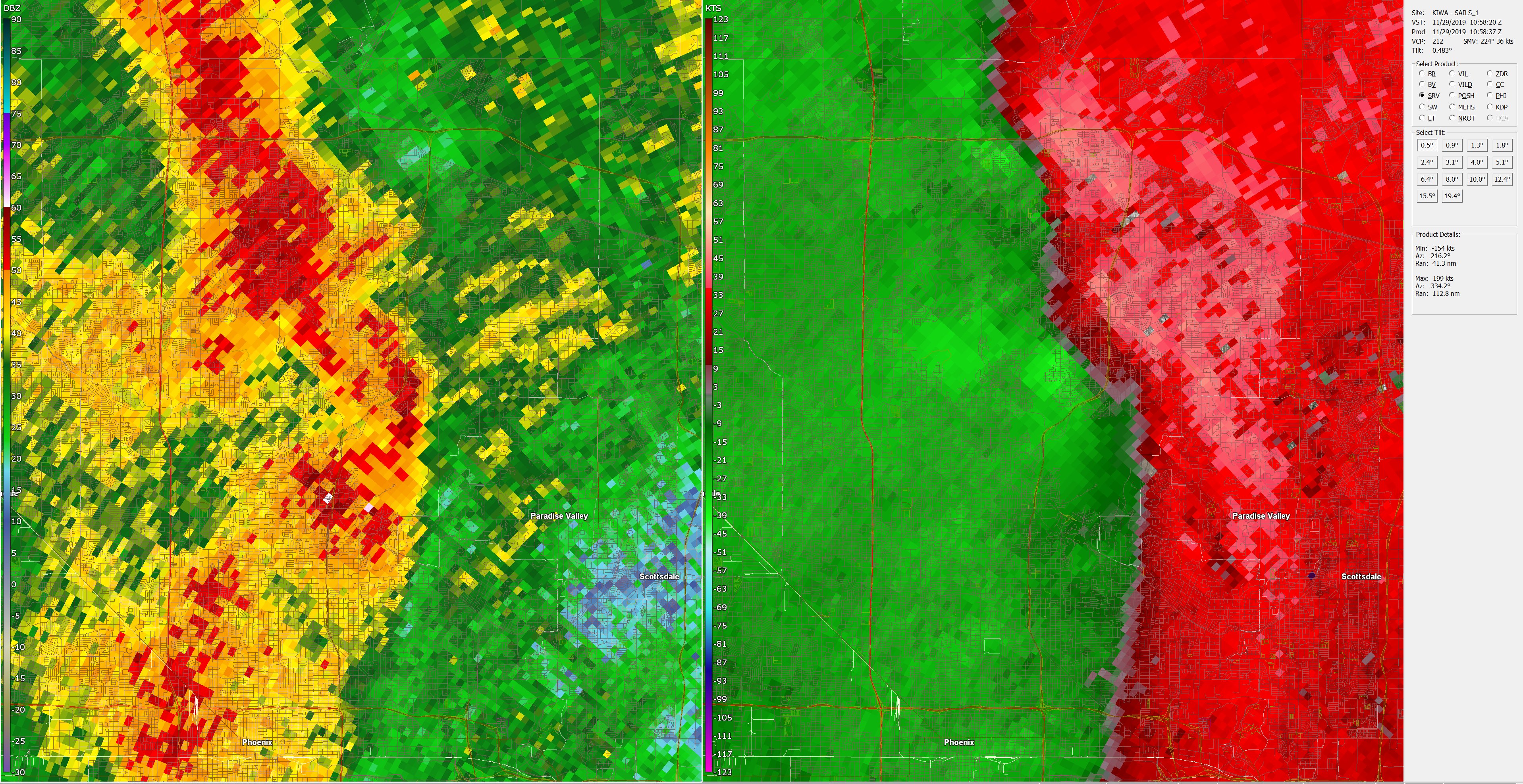
Reflectivity and Storm Relative Velocity at 3:58AM. Click on image for a larger image.

Photos courtesy of Njegos Krunic (top) and Michael Taube (bottom)
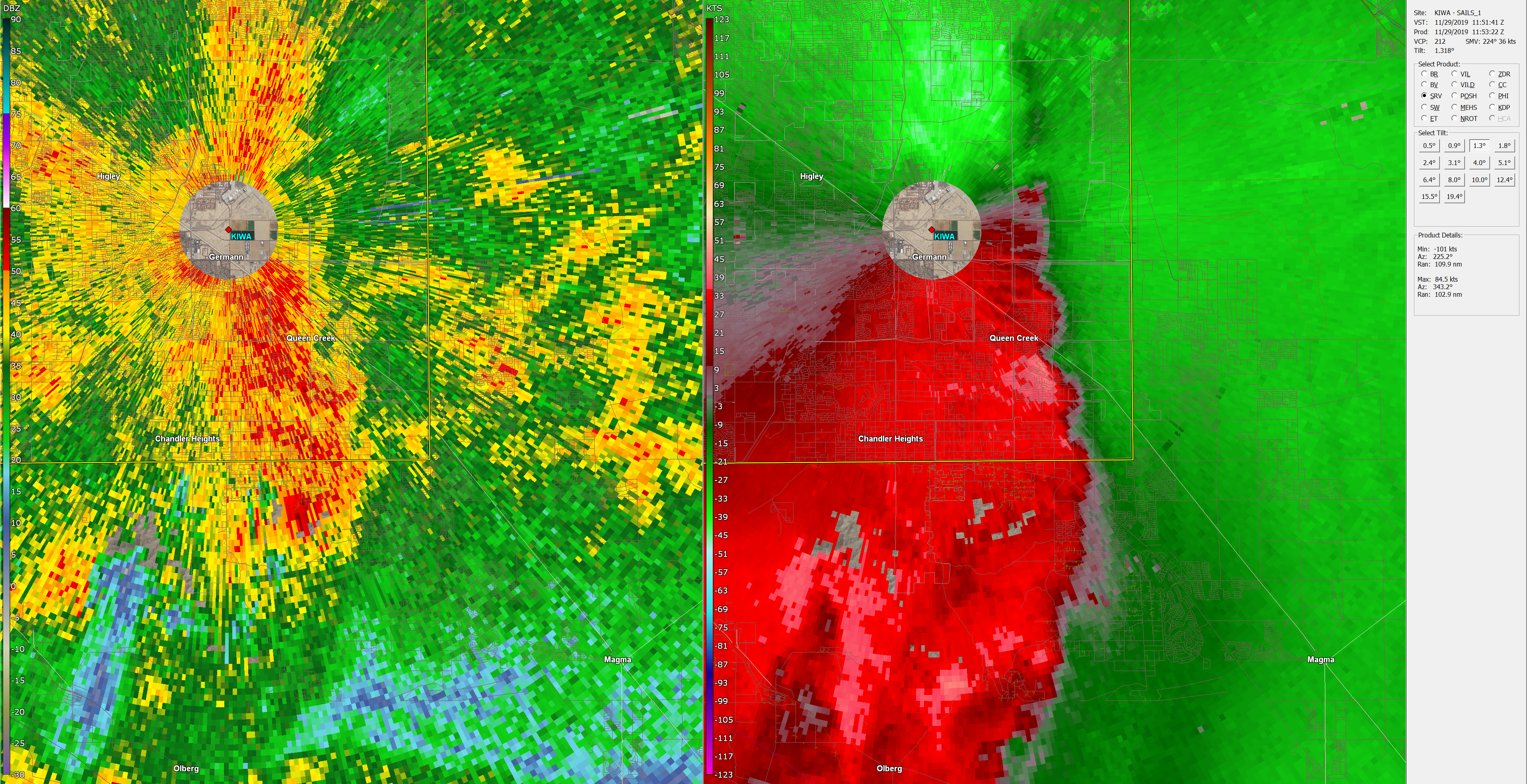
Gilbert EF0 Tornado: As the line of thunderstorms tracked into the Phoenix east valley between 4:30-5 AM, a third weaker tornado was confirmed. It began at 4:39 AM and ended at 4:46 AM, moving just east of Williams Gateway Airport in Gilbert. It caused mostly tree damage, resulting in an EF0 rating.

Tornado Damage Path in Gilbert, AZ.
Reflectivity and Storm Relative Velocity at 4:41AM. Click on image for a larger image.
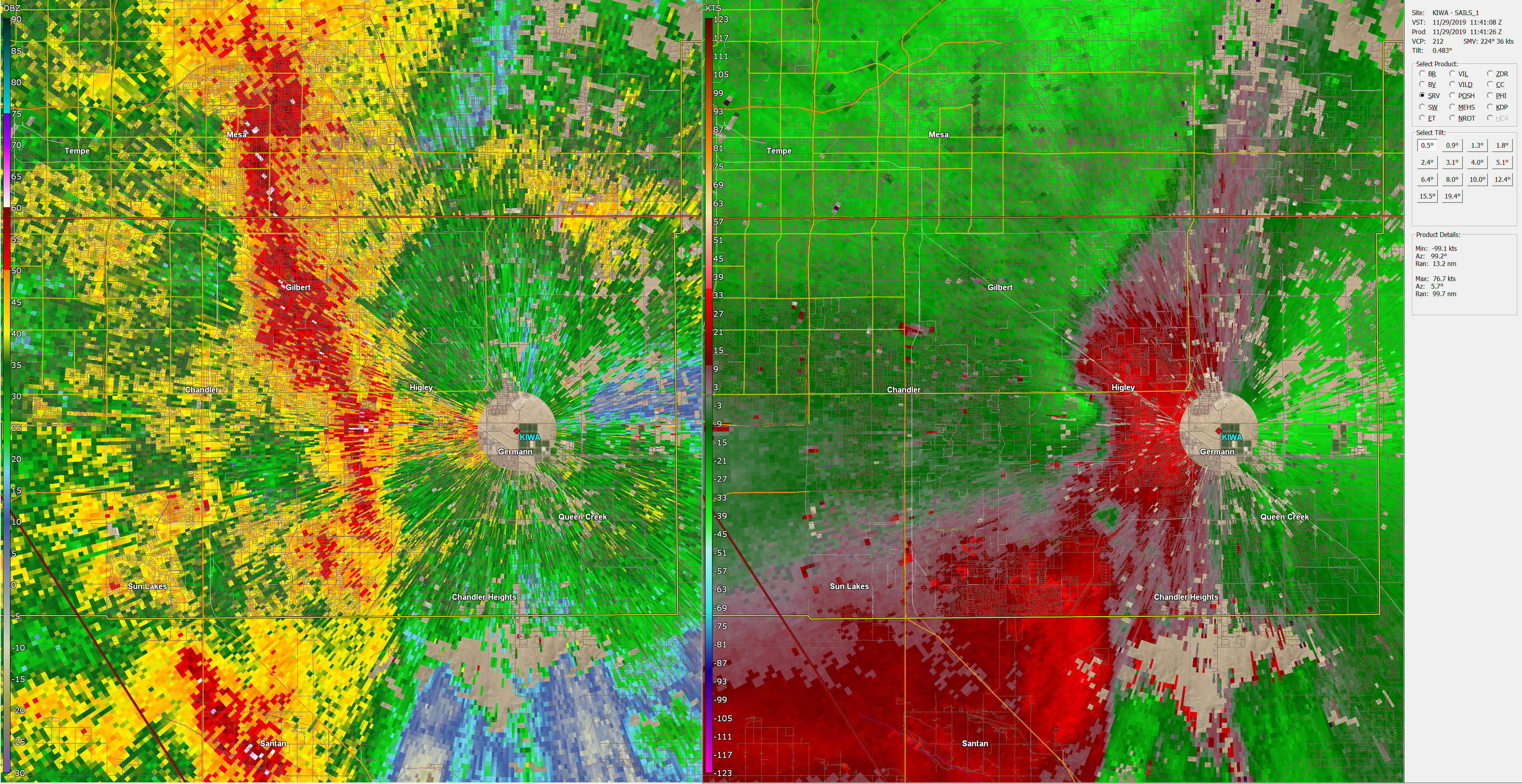
Queen Creek EF0 Tornado: The last confirmed tornado touched down at 4:51 AM in Queen Creek causing roof damage and downing multiple trees, resulting in an EF0 rating.

Tornado Damage Path in Queen Creek, AZ.
Reflectivity and Storm Relative Velocity at 4:51AM. Click on image for a larger image.
This weather system was strong enough to bring gradient southerly wind gusts ahead of the cold front to around 50 mph in Phoenix. Once the cold front (marked by the squall line) moved through, winds abruptly switched out of the west-northwest. This animated loop of radar velocities shows the dramatic wind shift with the cold front.
Phoenix Radar Base Velocity 245AM to 545AM Nov 29 2019. Click on image for a loop.
Earlier during the event: The cold front and its band of heavy rain showers and thunderstorms had swept through southeast California and southwest Arizona late afternoon and evening prompting a few severe thunderstorm warnings and several flash flood warnings. The widespread heavy rainfall with amounts of 1 - 1.5" in many places caused flash flooding, prompting many road closures across eastern Imperial and eastern Riverside Counties in California and La Paz County in Arizona.
Heavy rainfall also fell across much of central Arizona between 11 PM and 6 AM prompting numerous Flash Flood Warnings and Advisories. Rainfall upwards of over 2" fell across the high terrain north of Phoenix with widespread rainfall amounts of a 0.5 - 1.25" across the lower deserts.
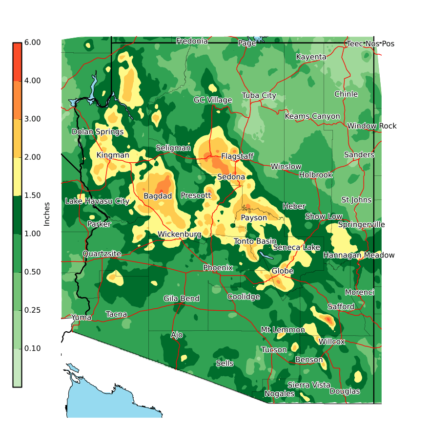
Storm Total Rainfall Nov 28-29 2019. Click the map for larger version.

