Preliminary Storm Report for 23 September 2019
By NWS Phoenix -- last updated at 2 PM on 24 September 2019

Still image of a tornado in New River, AZ
Overview: Beginning on Tuesday 17 September 2019, the NOAA/National Weather Service forecast the potential for a significant weather event to take place across much of Arizona in the 22-25 September 2019 time frame. Early indications were a low pressure system would move into the region from the northwest and interact with abundant remnant moisture from former Hurricane Lorena, which was moving northward in the Eastern Pacific Ocean but ultimately decayed near central Baja California. Initial forecasts called for widespread 1-3" of rain with localized higher, possibly historic, amounts. As the event drew closer, the threat of historic flooding lessened, though widespread heavy rainfall remained a significant concern. The threat for severe weather, including large hail, damaging winds, and isolated tornadoes also increased.

Estimated storm total rainfall (11 PM Sunday 22 September 2019
through 5 AM Tuesday 24 September 2019). Click for larger version.
During the late evening hours of Sunday 22 September 2019, showers and thunderstorms began to develop across portions of Arizona. A band of heavy rain developed during the early morning hours on Monday 23 September 2019 and moved south-to-north across portions of Pinal, Maricopa, and Gila counties, resulting in widespread flooding. A brief break was noted during the mid morning, with additional showers and thunderstorms developing by late morning. This activity continued through most of the day and even into the early overnight hours on Tuesday 24 September 2019.

Regional radar at 11:26 PM on Monday 23 September 2019. Click here for full event loop.
New River Tornado: Strong thunderstorms began to develop across northern Maricopa County near 11 AM. As the hour progressed, a few of the storms began to take on the structure of supercell thunderstorms. The eastern-most storm continued to show a gradual increasing trend of broad rotation as viewed on radar. The strongest and tightest rotation was noted on radar between 12:09 PM and 12:15 PM. A tornado warning was issued at 12:14 PM valid through 12:45 PM [link]. The area was under a Severe Thunderstorm Watch, was issued at 9:50 AM and in effect through 8 PM.

Radar view from TPHX (terminal doppler radar, top) and KIWA (WSR-88D, bottom) of
tornadic thunderstorm at 12:09 PM.Left side displays lowest angle reflectivity
and right side displays storm-relative motion. Click here for loop.

Map of tornado path in New River, AZ.
Based on credible photo and video evidence, NWS Phoenix personnel conducted a damage survey of the New River area. NWS Phoenix confirms a tornado touched down in New River, near 18th Street and Circle Mountain Road. The tornado touched down at 12:07 PM and remained on the ground until 12:09 PM. The total path length was 1 mile with a width of 100 yards. Estimated wind speeds were 80 mph, giving a high-end EF0 rating on the Enhanced Fujita Scale. Damage included uprooted trees and roof damage.
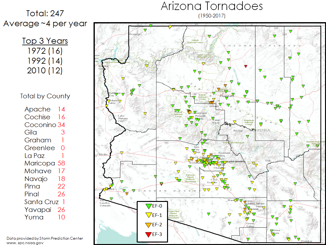
Map of historical tornadoes in Arizona (1950-2017).
Tornadoes while rare, are not unheard of in Arizona. On average, there are four tornadoes per year. The last confirmed tornado in the Phoenix area was a landspout tornado in Chandler on 30 July 2019 [link]. The last tornado warning issued in the Phoenix area was 21 January 2010 [link, link]. A significant tornado outbreak occurred across northern Arizona on 6 October 2010 [link], just a day after significant hail storms impacted the Phoenix area [link].
NWS Forecasts The potential for a significant weather event began to appear in NWS provided information as early as Tuesday 17 September 2019. That morning’s Area Forecast Discussion stated “We are currently watching a potential significant upper level low shown diving into the Southwestern U.S. for early next week”. A tweet later that day indicated the potential for remnant tropical moisture to impact the extended forecast. Forecasts over the next several days continued to highlight the potential for active weather. Daily briefings were provided by NWS Phoenix to core partners, beginning Tuesday 17 September 2019 and continuing through the event.
Beginning with the Day 3 Severe Thunderstorm Outlook issued by the Storm Prediction Center (SPC) at 12:23 AM on Saturday 21 September 2019 valid from 5 AM Monday 23 September 2019 through 5 AM Tuesday 24 September 2019, there was a Slight Risk for severe weather in central Arizona. The Slight Risk remained in the forecast, increasing to an Enhanced Risk for west-central Arizona with the Day 1 Severe Thunderstorm Outlook issued at 5:49 AM on Monday 23 September 2019. A Severe Thunderstorm Watch, indicating conditions were favorable for severe weather, was issued by SPC at 9:50 AM Monday 23 September 2019 valid through 8 PM Monday 23 September 2019. SPC also issued several Mesoscale Discussions for Arizona as the event unfolded [link].

