Storm Report for August 13-14, 2021
Last updated at 12 PM on August 19, 2021
Impacts: Localized wind damage, widespread heavy rains, numerous instances of flash flooding and unfortunately loss of life.
Strong to severe thunderstorms moved through central and southwest Arizona during the late evening hours of August 13, 2021 and into the morning hours of August 14, 2021. An unusually humid airmass was in place, fueling the thunderstorms and allowing them to produce very heavy rainfall. Rain fell at the rate of 2-3” per hour with more intense, localized amounts of 6” per hour. This resulted in numerous instances of flash flooding.
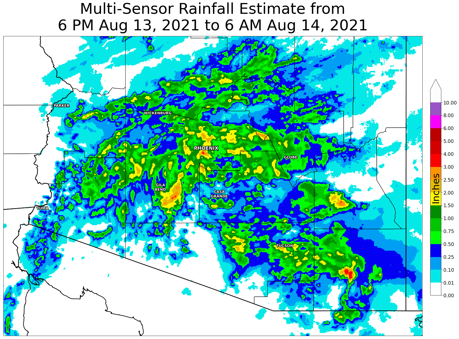
Fig. 1. Rainfall estimates (based on gage-adjusted radar data from the Multi-Radar Multi-Sensor [MRMS] system) across southern Arizona from 6 PM on Aug. 13, 2021 to 6 AM on Aug. 14, 2021. Widespread areas received 0.5 to 2.0 inches of rain, with a few spots exceeding 3 inches.
Heavy rain moved through northern Maricopa county, with some of the higher rain amounts observed near Fountain Hills and Phoenix. At various times the rain caused Interstate 17 to close at four locations (Greenway Road, Thunderbird Road, Indian School Road, and at the Durango Curve). Following the initial heavy rain, several hours of light to moderate rain fell across the Phoenix area during the overnight hours. The Phoenix Rainfall Index for both days amounted to 0.77” and pushed the total for the monsoon to approximately 4.4”.
Fig. 2. Observed rainfall amounts from the Flood Control District of Maricopa County. The heaviest rain fell near Fountain Hills and also through Phoenix.
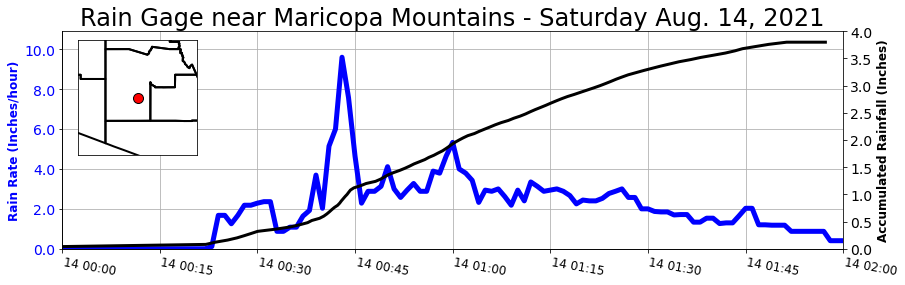
Once the rain moved further south, additional heavy rain fell across southwest Maricopa County including east of Gila Bend, AZ. Multi-sensor rain estimates depicted an area of 1.5 to 3.5 inches with a rain gage from the Maricopa County Flood Control District measuring nearly 4 inches within two hours. Rain rates at this one gage briefly exceeded 8 inches per hour, indicative of how torrential the rain was at times.
Fig. 3. Observed rainfall amounts from the Flood Control District of Maricopa County. The heaviest rain fell near Fountain Hills and also through Phoenix.
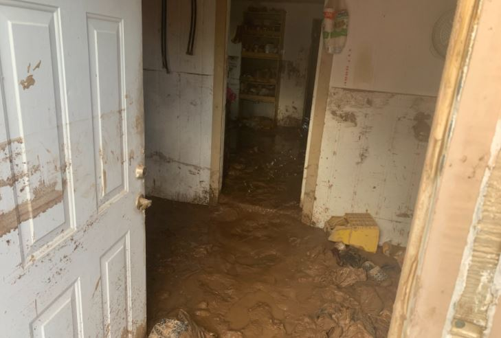
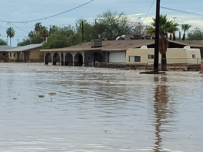
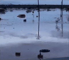
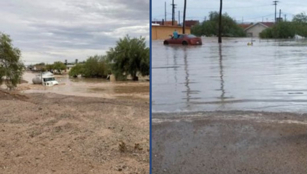
This heavy rain resulted in significant flooding within the Gila Bend community. Several water rescues were conducted by ground and air, including from rooftops of homes. Media reports indicate 30 people were rescued due to flooding and 100 people displaced by the damage. Sadly two fatalities were reported during the event. Damage occurred to 130 homes and 17 businesses and a rail bridge was washed out. A State of Emergency was declared by Gila Bend Mayor Chris Riggs on the morning of Aug. 14 and a Declaration of Emergency was declared by Gov. Ducey on the afternoon of Aug. 16.
|
|
|
|
|
|
|
Fig. 4. Images of flooding and damage in Gila Bend, AZ from early morning heavy rain on Aug. 14, 2021. Credit (clockwise): AZFamily, (name withheld), Somerton News, ABC15. |
|
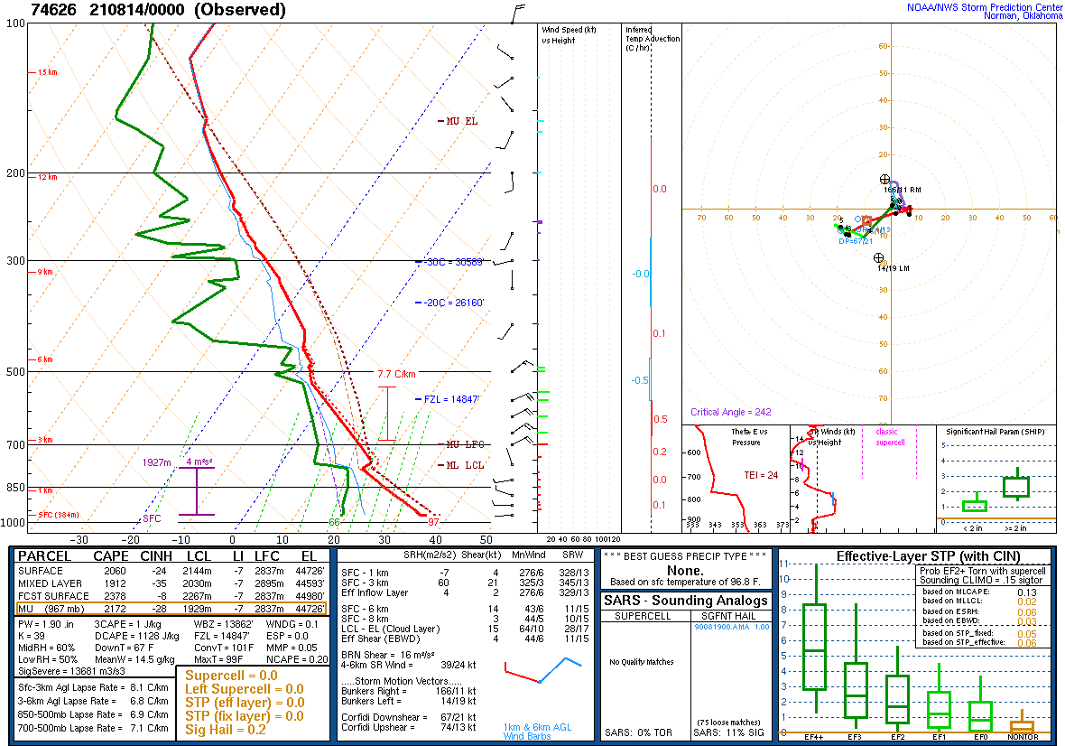
Showers and thunderstorms initially developed over the mountains of eastern Arizona. The weather pattern featured stronger-than-usual winds from the northeast in the middle parts of the atmosphere, conducive to moving storms from the mountains into the lower deserts. In addition, humidity levels were much above normal. Precipitable water values (indicating how much water is in the air if it was also condensed out) was near 2 inches, which is near extreme values for mid August.
Fig. 5. A technical schematic of weather data obtained from a routine weather balloon release at 5 PM on Aug. 13, 2021 at the NWS Phoenix office. The data reflect an atmosphere with high amounts of moisture and instability, along with enhanced northeast winds.
Fig. 6. Mosaic radar imagery from 1 PM on Friday Aug. 13, 2021 to 10 AM on Saturday Aug. 14, 2021.
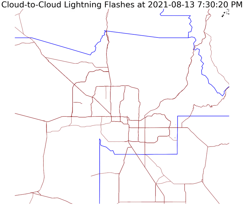
As the showers and thunderstorms moved into the lower deserts, they exploded - fueled by the very unstable airmass in place. With the high amounts of moisture in the atmosphere, they quickly began producing significant rainfall amounts and numerous Flash Flood Warnings were issued. A line of thunderstorms continued to roll southwest through western Maricopa, La Paz, and Yuma Counties. Very intense lightning was also noted when thunderstorms first moved into the Phoenix area. During the 10 PM hour on Aug. 13, 2021, there were ~450 lightning strikes across the Phoenix metro area - the most in a single hour since Aug. 28, 2019.
Fig. 7. Animation of lightning flashed across the Phoenix area from 730PM Aug. 13, 2021 to 1 AM Aug. 14, 2021. Data source: Earth Networks.
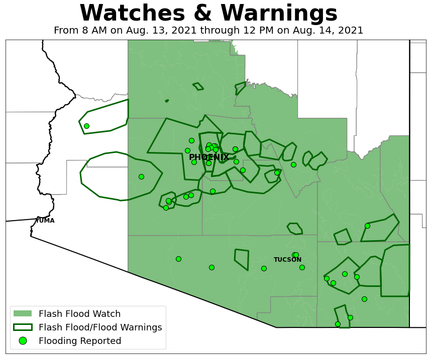
Rain chances were consistently 30-40% leading into the event. With the potential for heavy rain, a Flash Flood Watch was issued at 130 PM on Aug. 12, 2021 in effect from 5 PM on Aug. 12, 2021 to 5 PM on Aug. 15, 2021 (the watch would end up being extended through 5 AM on Aug. 17, 2021). During the event itself, 29 Flash Flood/Flood Warnings were issued.
Fig. 8. Spatial extent of Flash Flood Watch and Flash Flood/Flood Warnings issued for this event by NWS offices in Phoenix, Flagstaff, and Tucson. Locations where flooding was reported to NWS noted with green dots.
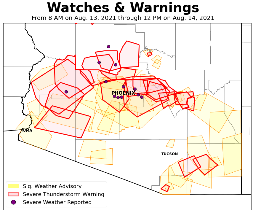
Although heavy rain was the most widespread and notable impact, there were some localized strong to severe winds including wind gusts of 60 mph and damage to power lines near Salome, AZ. The map below (interactive map available here) shows the locations of storm reports as relayed to the NWS as of Aug. 16, 2021. Nearly 50 reports were generated for this event from the NWS offices in Phoenix, Tucson, and Flagstaff.
Fig. 9. Spatial extent of Significant Weather Advisories and Severe Thunderstorm Warnings issued for this event by NWS offices in Phoenix, Flagstaff, and Tucson. Locations where severe weather was reported to NWS noted with purple dots.