New Forecast Zones for southwest Washington and northwest Oregon
The new weather forecast zones are officially here. These are described in depth below, along with a map.
"Now NWS Portland, why should I care?" Wow, we are glad you asked.
The new zones are specifically configured to make communicating and issuing watches, warnings, and advisories easier. In the past when we issued one of these hazards the map would show a blanketed warning on our website - despite us putting in effort to identify areas most at risk (above 500 ft, eastern portion of the Portland/Vancouver-Metro, etc). But now, with this new configuration you will be able to actually SEE what we mean. We hope that with these changes we will be able to better communicate with you so you can take action to stay safe.
How can I tell what in which forecast zone is my house located?
There are several ways in which this can be done.
- OPTION 1: Use the forecast map on the front page (weather.gov/pqr). When the forecast page appears, look down the left side of the forecast text until you see the section labeled 'Additional Forecast and Information." In that section, you will see the name of your forecast zone, as well a link to that zone. If you click on that link, the detailed forecast for that zone will appear. You can find the zone number in the URL, with the number being the last 3 digits.
- OPTION 2: Use the Detailed Hazards (also found on front page, under Current Hazards). Then, add the NWS Public Zones (found under the Overlays option, then Boundaries). The new forecast zones will appear as a bolder black line. Once you find your location, look at the shape of the forecast zone, and match up with the zone map shown below.
- OPTION 3: Use the text of the forecast zones, then look through the zones to determine the one that fits your area. Each zone will start with a WAZxxx or ORZxxx where the WA is the state, Z is zone, and the xxx is the zone number.\
- OPTION 4: Use the list below to find the most appropriate zone number.
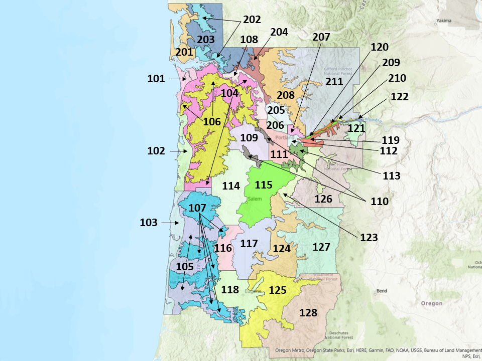
Detailed Descriptions of the New Forecast Zones in southwest Washington and northwest Oregon
In southwest Washington:
- 201 South Washington Coast - elevations below 500 feet from the coastline to far western portions of the Willapa Hills, including the Long Beach peninsula.
- 202 Willapa and Wahkiakum Lowlands - elevations below 500 feet.
- 203 Willapa Hills - elevations above 500 feet.
- 204 Cowlitz County Lowlands - elevations below 500 feet in Cowlitz County.
- 205 North Clark County Lowlands - elevations below 500 feet in northern Clark County (does NOT include city of Vancouver, but does include outlying rural areas such as Battle Ground, Ridgefield, and Brush Prairie).
- 206 Inner Vancouver Metro - covers the Vancouver metro to the west of 192nd Ave. This zone excludes eastern portions of the metro near the mouth of the Columbia River Gorge.
- 207 East Clark County Lowlands - covers eastern portions of the Vancouver metro/Clark County near the mouth of the Columbia River Gorge.
- 208 South Washington Cascades Foothills - covers elevations between 500-1500 feet in the south WA Cascade foothills.
- 209 West Columbia River Gorge - SR14 - covers elevations below 500 ft on the Washington side of the western Columbia River Gorge from Skamania/Clark county border eastward to just west of Carson , including SR14.
- 210 Central Columbia River Gorge - SR 14 - covers elevations below 500 ft on the Washington side of the central Columbia River Gorge from just west of Carson eastard to Underwood, including SR14.
- 211 South Washington Cascades - covers elevations above 1500 feet in the south Washington Cascades. Includes the town of Stabler, as well as Mount St. Helens.​
In northwest Oregon
- 101 Clatsop County Coast - covers coastal portions of Clatsop County, extending from Columbia River to near Cape Falcon. Includes Cannon Beach, Seaside, Astoria, and Gearhart.
- 102 Tillamook County Coast - covers coastal portions of Tillamook County, extending from Cape Falcon to Cascade Head. Includes Manzanita, Garibaldi, Tillamook, Pacific City and Neskowin.
- 103 Central Coast of Oregon - covers the coast from Cascade Head to Florence. Includes Lincoln City, Newport, Yachats, Sea Lion Caves and Florence.
- 104 North Oregon Coast Range Lowlands - covers elevations below 1000 ft in the north Oregon Coast Range, which includes the river valleys and most of the towns such as Vernonia.
- 105 Central Oregon Coast Range Lowlands - covers elevations below 1000 ft in the central Oregon Coast Range, which includes the river valleys and most of the towns, such as Mapleton and Eddyville.
- 106 North Oregon Coast Range - includes elevations above 1000 ft in the north Oregon Coast Range. While very few people live in this zone, it does include popular travel corridors to/form the coast, including US26 and ORE6. It also includes Wilson River Summit.
- 107 Central Oregon Coast Range - includes elevations above 1000 ft in the central Oregon Coast Range. While very few people live in this zone, it does include US20 to Newport and ORE126 to Florence.|
- 108 Lower Columbia River - elevations below 500 ft along the lower Columbia River on the Oregon side, including Clatskanie, Rainier, St Helens and Scappoose.
- 109 Tualatin Valley - elevations mainly below 500 ft between the West Hills and the Chehalem Mountains. Includes Beaverton, Hillsboro, Banks, Forest Grove, Tualatin, Aloha, and Tigard.
- 110 West Hills and Chehalem Mountains - covers elevations above 500 feet in the West Hills and Chehalem Mountains.
- 111 Inner Portland Metro - covers the heart of Portland, including downtown Portland (mainly elevations below 500 feet).
- 112 East Portland Metro - covers the eastern Portland metro near the mouth of the Columbia River Gorge from 162nd Ave eastward. Includes Troutdale, Wood Village, Fairview, northern Gresham. Does NOT include Corbett, which is in ORZ119.
- 113 Outer Southeast Portland Metro - covers elevations between 500-1000 feet in the outer southeast Portland metro (Boring, Damascus, Powell Butte Nature Park).
- 114 West Central Willamette Valley - covers elevations below 1000 feet in the west central Willamette Valley. Includes Yamhill, McMinnville, Amity, Perrydale, Dallas and west Salem.
- 115 East Central Willamette Valley - covers elevations below 1000 feet in the east central Willamette Valley. Includes Aurora, Woodburn, Silverton, Molalla, Stayton, and Salem.
- 116 Benton County Lowlands - covers elevations below 1000 feet in Benton County. Includes Corvallis, Philomath, Greenberry, and Monroe.
- 117 Linn County Lowlands - covers elevations below 1000 feet in Linn County. Includes Harrisburg, Lebanon, Halsey, Albany, Sweet Home, and Brownsville.
- 118 Lane County Lowlands - covers elevations below 1000 feet in Lane County. This includes Eugene, Springfield, Creswell, Cottage Grove, Veneta, Fern Ridge Reservoir, Coburg, Junction City, and Cheshire.
- 119 West Columbia River Gorge of Oregon above 500 ft - covers elevations above 500 feet in the western Columbia Gorge on the Oregon side, from just east of Sandy River to just east of Cascade Locks. Includes Corbett.
- 120 West Columbia River Gorge I-84 Corridor - covers elevations below 500 feet in the western Columbia River Gorge on the Oregon side from just east of Troudale to just east of Cascade Locks. Includes the I-84 corridor, as well as Multnomah Falls and Cascade Locks.
- 121 Upper Hood River Valley - covers elevations between 500-2000 feet from Odell to Parkdale. This zone does NOT include Hood River.
- 122 Central Columbia River Gorge I-84 Corridor - covers elevations below 500 feet in the Central Columbia Gorge on the Oregon side, from just east of Cascade Locks to the Hood River/Wasco county line. Includes the I-84 corridor, as well as Hood River.
- 123 Clackamas County Cascades Foothills - includes elevations between 1000-2000 feet in Clackamas County. Includes Cherryville, Brightwood, Welches, and portions of Sandy. Also, inlcludes highways US-26.
- 124 Cascades Foothills of Marion and Linn Counties - includes elevations between 1000-2000 feet in Marion and Linn Counties. Includes Silver Falls, Mill City, Gates, Detroit Lake, Idanha, and Cascadia. Also, inlcludes highways US-20 and OR-22.
- 125 Lane County Cascades Foothills - includes elevations between 1000-2000 feet in Lane County. Includes Oakridge, Dorena, Vida, Nimrod, Blue River, and McKenzie Bridge. Also, inlcludes highways OR-58 and OR-126.
- 126 North Oregon Cascades - includes elevations above 2000 feet in the north Oregon Cascades. Includes Government Camp, Mt. Hood, and US-26.
- 127 Cascades of Marion and Linn Counties - includes elevations above 2000 feet in the Cascades of Marion and Linn Counties. Includes Santiam Pass, Mount Jefferson, and Marion Forks. Also, inlcludes highways US-20 and OR-22.
- 128 Cascades of Lane County - includes elevations above 2000 feet in the Cascades of Lane County. Includes McKenzie Pass and Willamette Pass, as well as McCredie Springs and Waldo Lake. Also, inlcludes highways OR-126, OR-58 and the old McKenzie Highway.