
A storm system will continue to bring areas of heavy snow, gusty to high winds, and critical fire weather from the Sierras through the central and southern Plains through Friday. Gusty winds are expected today into Friday along the Appalachians through the Mid-Atlantic and into southern New England behind a strong cold front moving off the East Coast. Read More >
Philadelphia/Mt Holly
Weather Forecast Office
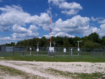
Automated Surface Observing Systems (ASOS)
The ASOS program is a joint effort of the National Weather Service (NWS), the Federal Aviation Administration (FAA), and the Department of Defense (DoD). The ASOS systems serves as the nation’s primary surface weather observing network. ASOS is designed to support weather forecast activities and aviation operations and, at the same time, support the needs of the meteorological, hydrological,and climatological research communities. For complete details on the ASOS program, click here.
|
|
To view current observations from the ASOS equipment (and buoys) in our County Warning Area, click here. This equipment provides information on the following basic weather elements:
|
|
US Dept of Commerce
National Oceanic and Atmospheric Administration
National Weather Service
Philadelphia/Mt Holly
732 Woodlane Rd.
Mount Holly, NJ 08060
609-261-6600
Comments? Questions? Please Contact Us.


 Coastal Flood
 Marine Forecasts
 Text Products
 Climate Information
 Skywarn
 Submit Storm Report
 Weather Event Archives
 Forecast Discussion
 Emergency Managers
 Briefing Page