National Weather Service United States Department of Commerce

Area River and Lake Summary

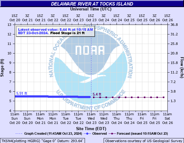
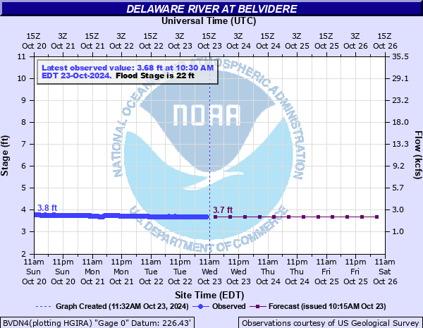
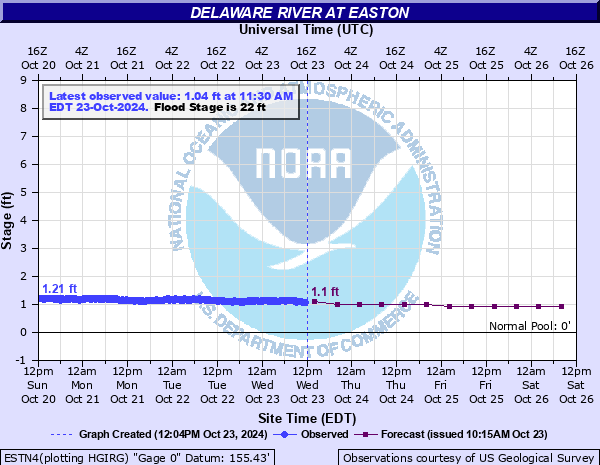
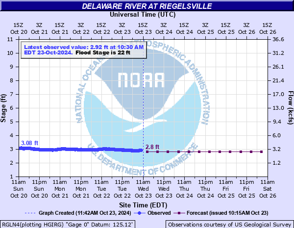
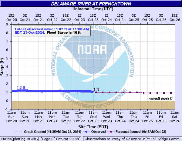
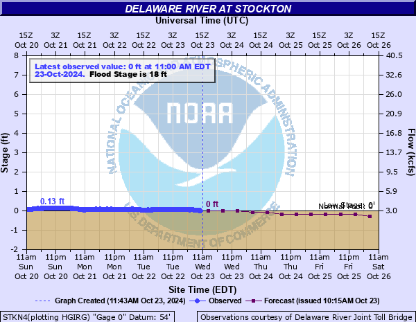
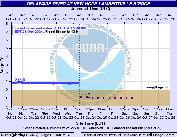
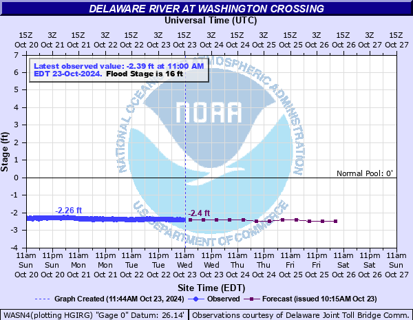
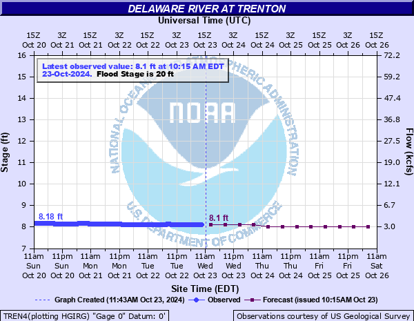
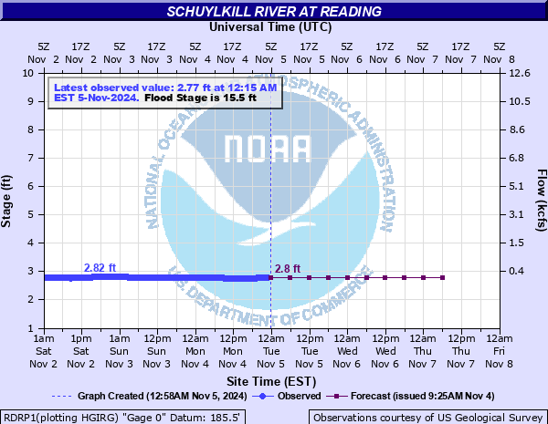
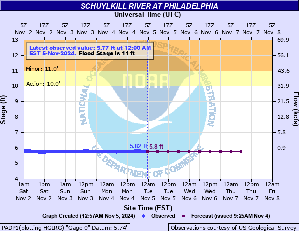
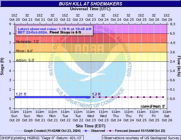
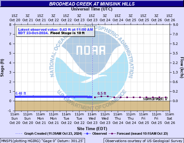
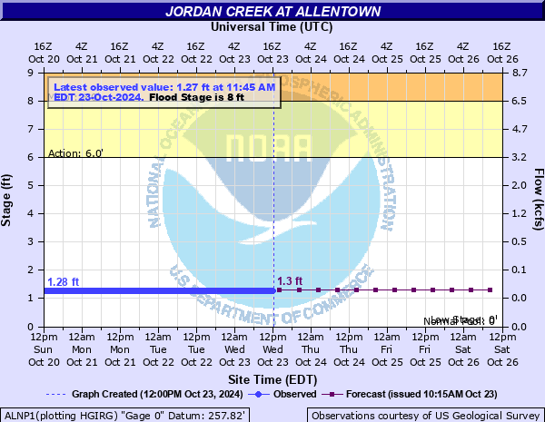
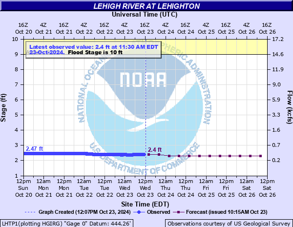
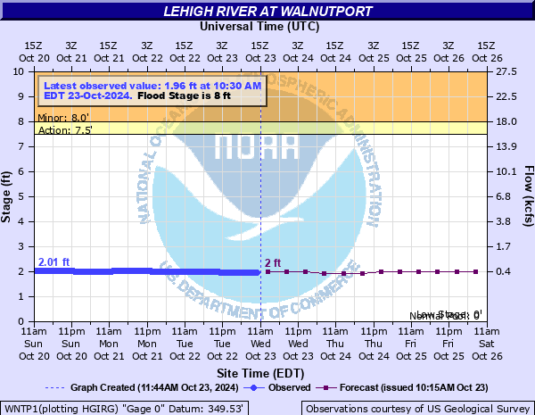
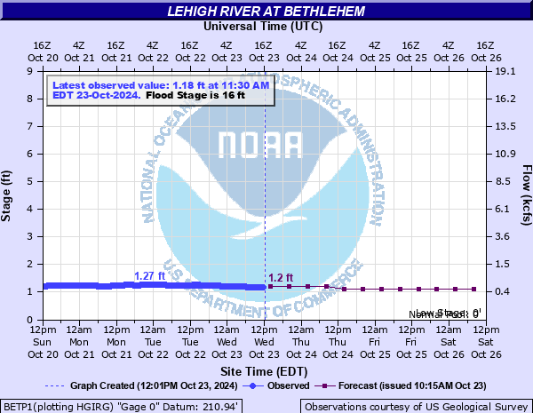
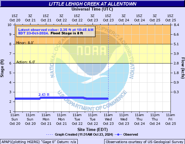
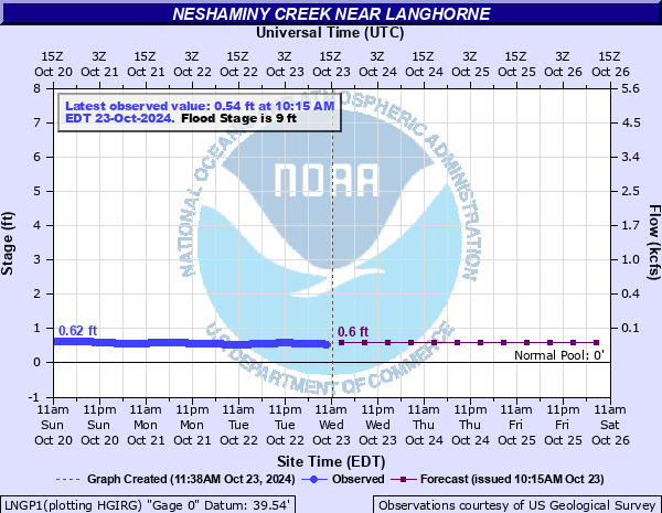
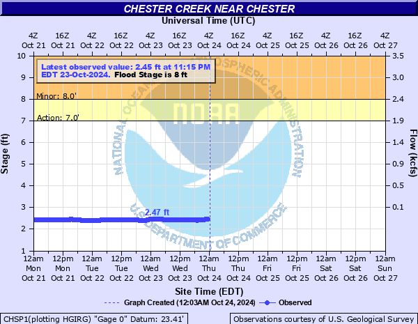
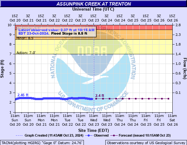
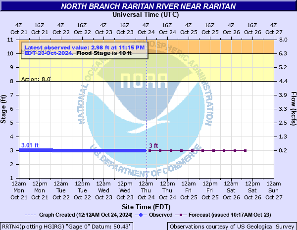
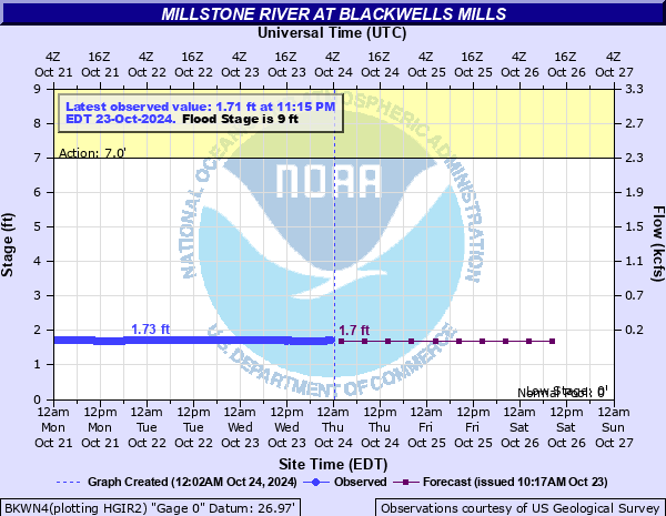
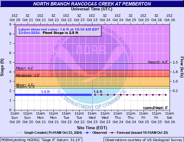
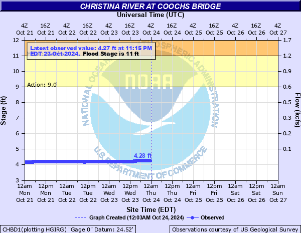
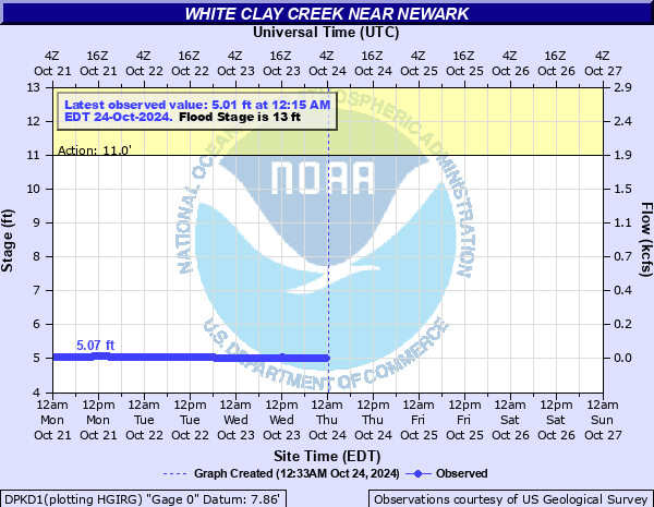
Mouse over each site to display hydrograph.

Hydrographs (showing stages and flows over time) are available through AHPS (Advanced Hydrologic Prediction Service) by clicking site names.

No Flood Near Flood Minor Flood Moderate Flood Major Flood

River Conditions at: 4:05 PM EDT 03/25/2025

Location
Flood
Stage (ft.)
Observed
(ft.)
24-Hr
Change
Crest (ft.) Forecast for 8.0 AM
Wed. Thu. Fri. Sat.
Delaware River
21.0 6.77 -0.1 6.7 6.5 6.4 6.3
22.0 5.74 -0.3 5.8 5.4 5.2 5.1
22.0 3.89 -0.2 3.8 3.5 3.1 2.9
22.0 5.3 -0.1 5.3 5.0 4.7 4.6
16.0 3.14 -0.2 3.3 3.0 2.7 2.6
18.0 2.29 -0.1 2.3 2.3 1.9 1.8
13.0 1.74 -0.1 1.8 1.8 1.3 1.2
16.0 0.35 -0.1 0.4 0.4 -0.1 -0.2
20.0 9.84 -0.1 9.9 9.9 9.5 9.4
Schuylkill River
9.0 -0.43 +0.5 3.6 -0.4 -2.1 -2.9
12.0 5.24 -0.0 5.2 5.2 5.2 5.1
15.5 3.45 -0.1 3.4 3.4 3.4 3.4
12.5 1.94 -0.1 2.0 2.0 1.9 1.8
13.0 8.13 -0.0 8.2 8.2 8.2 8.1
11.0 6.16 0.0 6.2 6.1 6.1 6.1
Bush Kill
6.0 2.26 -0.0 2.2 2.2 2.1 2.1
Brodhead Creek
10.0 2.02 - 2.0 2.0 1.9 1.8
Jordan Creek
8.0 1.84 -0.0 1.8 1.8 1.8 1.8
Lehigh River
10.0 3.61 +0.1 3.6 3.6 3.5 3.5
8.0 3.01 +0.1 3.0 3.0 2.9 2.9
16.0 2.24 +0.1 2.2 2.2 2.1 2.1
Little Lehigh
8.0 2.36 -0.1 - - - - -
Perkiomen Creek
11.0 1.64 0.0 1.6 1.5 1.4 1.4
Neshaminy Creek
9.0 1.6 +0.2 1.5 1.4 1.3 1.3
Brandywine Creek
7.0 3.15 -0.0 - - - - -
9.0 2.03 0.0 2.0 2.0 1.9 1.9
16.5 11.82 0.0 11.8 11.8 11.8 11.8
Chester Creek
8.0 2.72 0.0 - - - - -
Assunpink Creek
8.5 3.56 -0.0 3.6 3.5 3.4 3.3
Passaic River
8.0 5.34 -0.0 5.3 5.3 5.2 5.1
6.0 4.24 -0.1 4.2 4.1 4.1 4.0
19.0 15.89 -0.2 15.8 15.7 15.3 14.9
8.5 3.9 -0.1 3.9 3.9 3.8 3.6
7.0 2.67 -0.0 2.7 2.7 2.5 2.3
Ramapo River
11.5 8.03 0.0 8.1 8.1 8.0 7.9
Pompton River
16.0 9.4 0.0 9.4 9.4 9.2 9.1
Wanaque River
6.0 1.3 -0.0 1.3 1.3 1.3 1.3
Pequannock River
5.5 3.41 +0.1 3.3 3.2 3.2 3.1
Rockaway River
4.5 1.25 +0.1 1.2 1.2 1.1 1.1
5.0 2.79 +0.1 2.8 2.8 2.7 2.6
Raritan River
14.0 4.65 +0.1 4.7 4.6 4.5 4.4
28.0 1.61 +0.4 18.3 18.1 17.7 17.5
10.0 3.1 0.0 3.1 3.1 3.0 3.0
8.0 2.71 +0.1 2.7 2.6 2.6 2.6
Millstone River
9.0 2.62 +0.3 2.6 2.5 2.2 2.1
Rancocas Creek
2.5 1.87 +0.1 1.9 1.9 1.8 1.7
Christina River
11.0 4.28 -0.1 - - - - -
Red Clay Creek
7.0 2.93 - - - - - -
White Clay Creek
13.0 5.35 -0.1 - - - - -