Overview
|
A strong frontal system impacted the mid-Atlantic from February 17 through February 18, 2022. A strengthening area of low pressure tracked from the southern Plains through the Ohio Valley and just east of the Great Lakes, passing west of the coastal mid-Atlantic. Unusually strong wind fields were present with this system, with an expansive region of south-southwesterly 850 mb winds exceeding 70 kt ahead of it. This brought an unseasonably warm air mass into the region, with multiple record high temperatures broken on February 17. It also led to a period of strong surface winds. Winds ramped up on the night of the 17th as the low level jet reached its maximum strength. Widespread gusts of 40 to 45 mph with some gusts over 50 mph were observed in the predawn hours of the 18th. As sunrise approached, so did the strong cold front associated with this system. The strong frontal forcing and extreme wind fields, coupled with a small amount of instability, allowed a fine, low-topped convective line to develop just ahead of the front. This line produced strong to severe convective wind gusts, especially in the vicinity of the Delaware Valley. Between the convective and synoptic winds, a number of reports of tree damage were received, and several thousand customers were temporarily without electricity. The front and associated convective line moved offshore just after sunrise on the 18th. Gusty northwest winds continued for a few hours in the wake of the front, but they steadily ramped down through the day as cooler and more tranquil weather returned. |
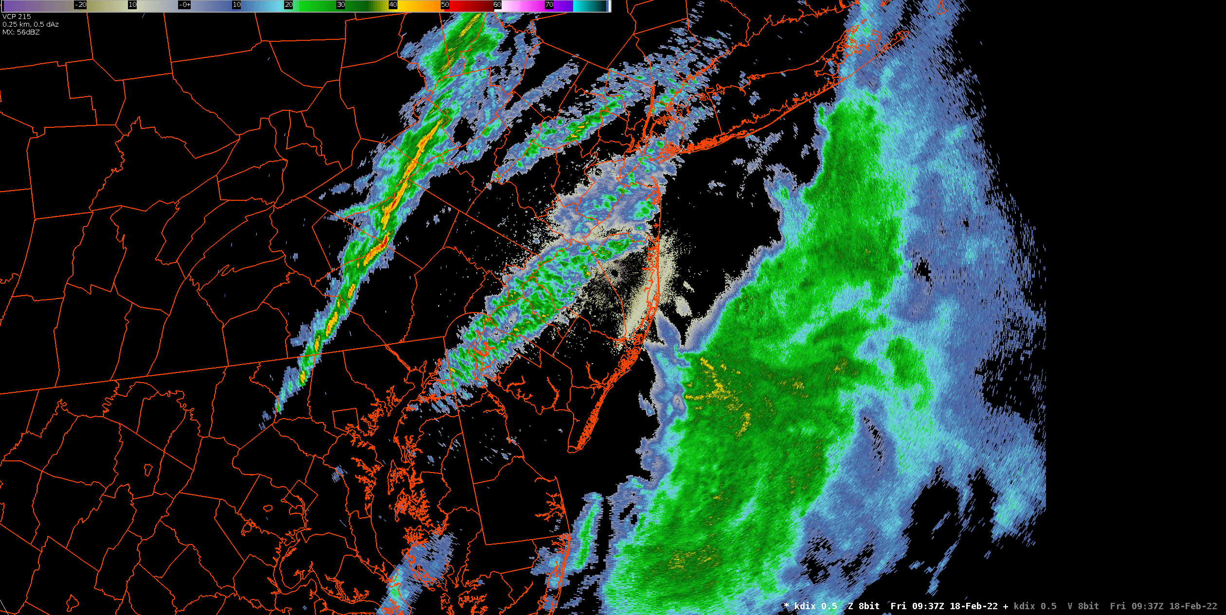 KDIX radar reflectivty loop from approximately 4:30 to 7:30 AM EST February 18, 2022, showing the squall line moving through the region. Click to enlarge. |
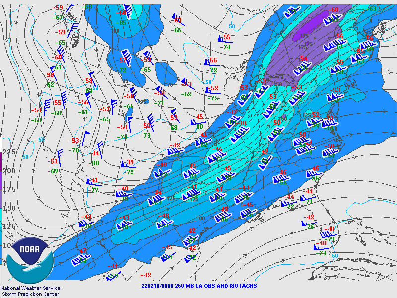
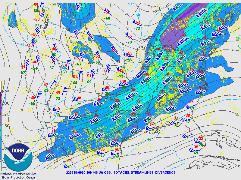
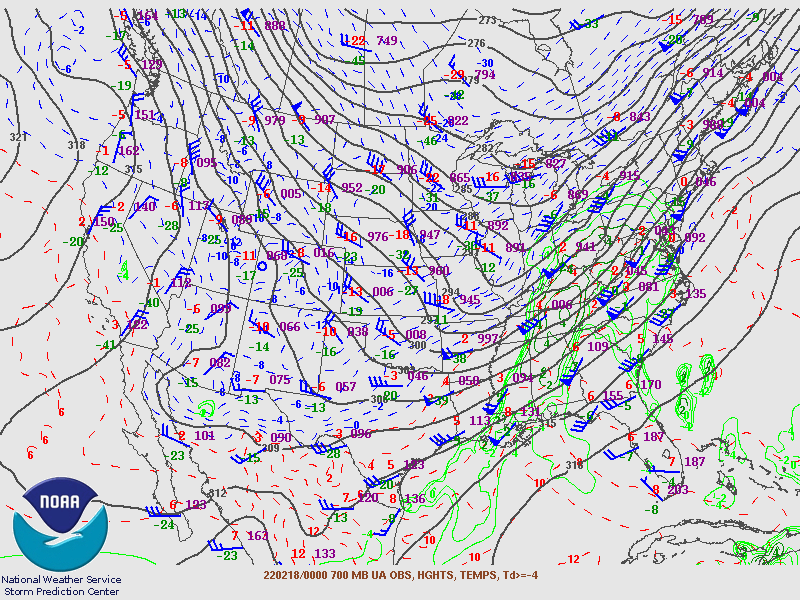
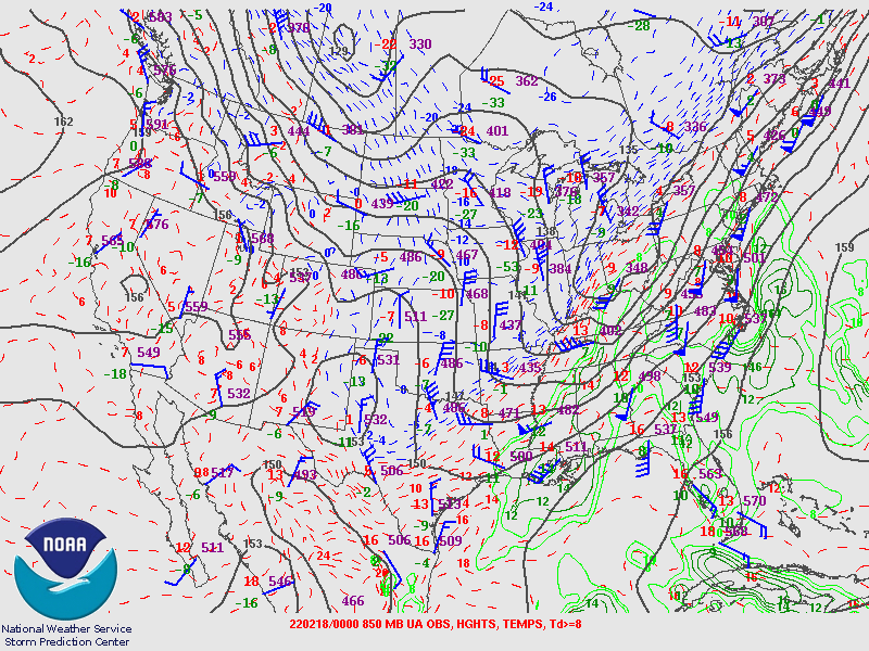
Synoptic Overview at 00z 18 Feb 2022 (courtesy of SPC)
 |
 |
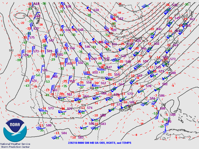 |
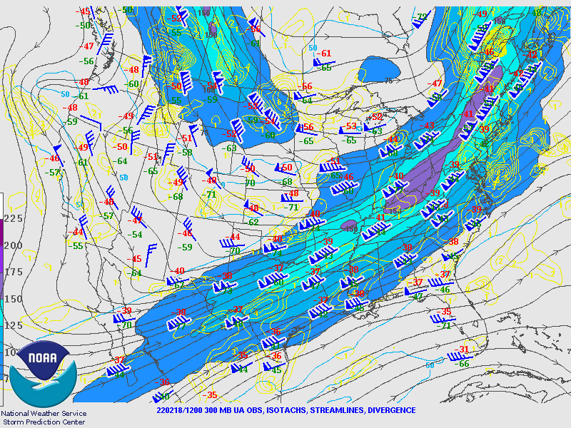
| Figure 1: 250-mb analysis | Figure 2: 300-mb analysis | Figure 3: 500-mb analysis |
 |
 |
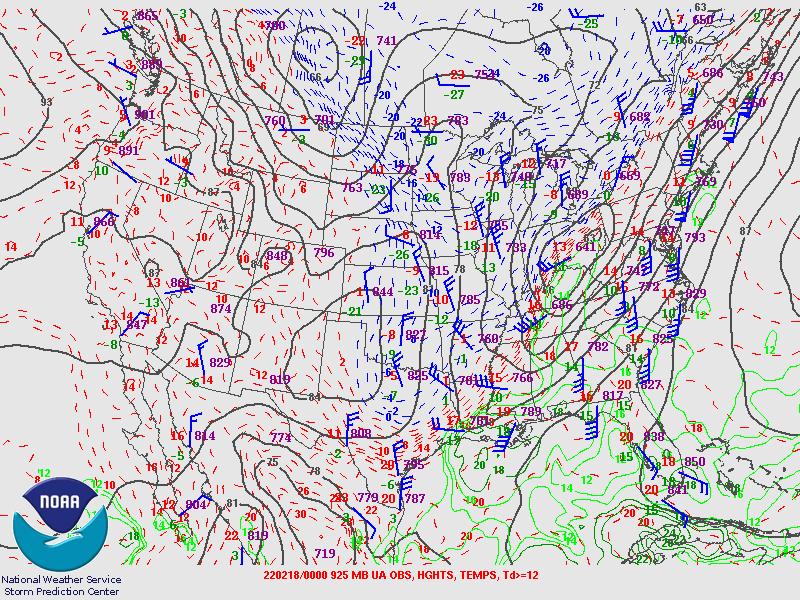 |
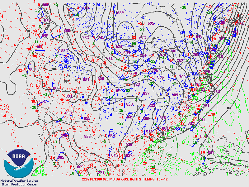
| Figure 4: 700-mb analysis | Figure 5: 850-mb analysis | Figure 6: 925-mb analysis |
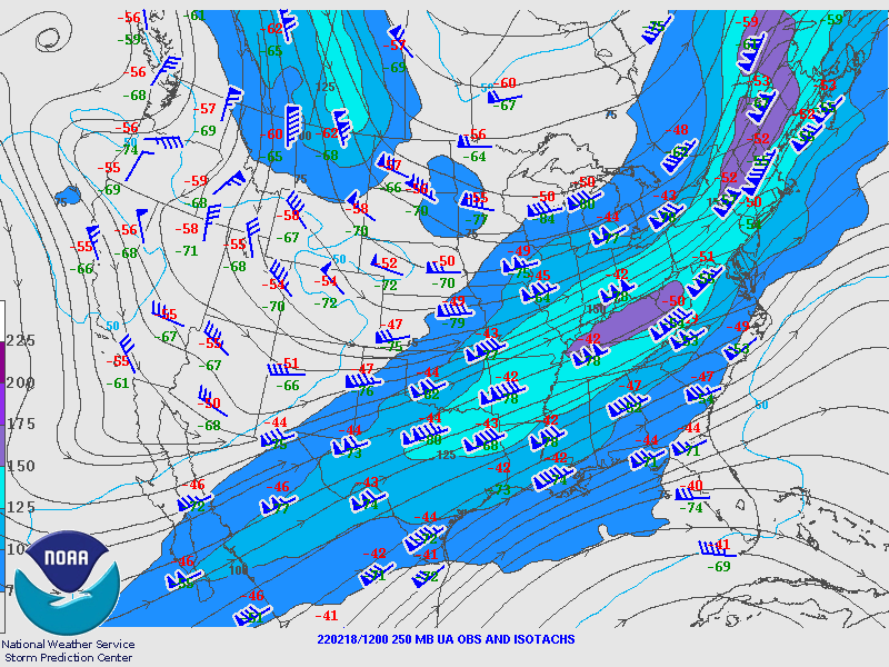
Synoptic Overview at 12z 18 Feb 2022 (courtesy of SPC)
 |
 |
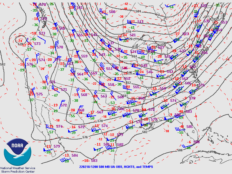 |
| Figure 7: 250-mb analysis | Figure 8: 300-mb analysis | Figure 9: 500-mb analysis |
 |
 |
 |
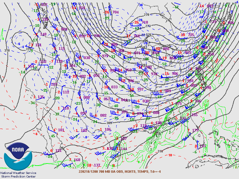
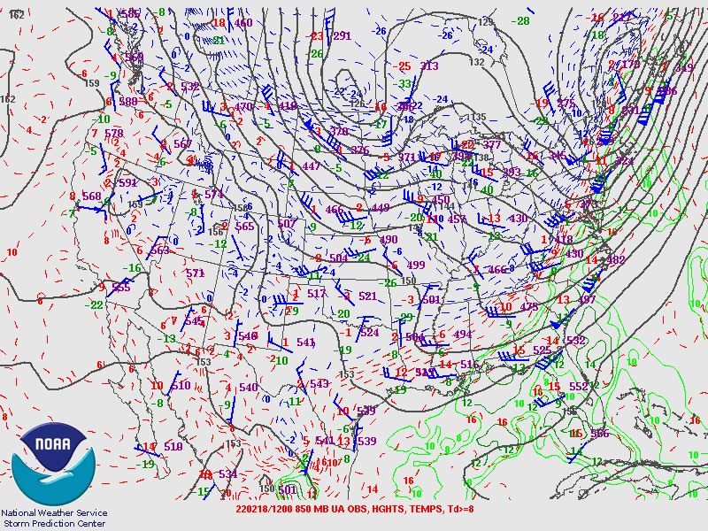
| Figure 10: 700-mb analysis | Figure 11: 850-mb analysis | Figure 12: 925-mb analysis |
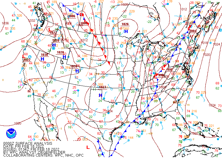
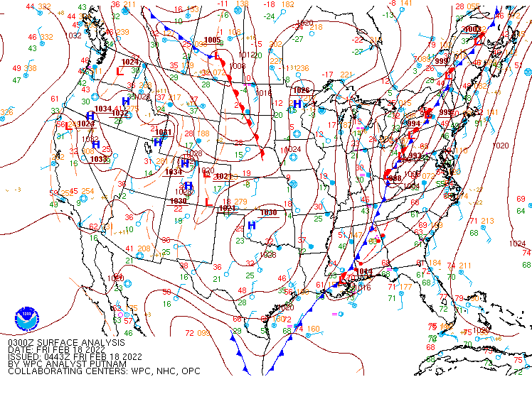
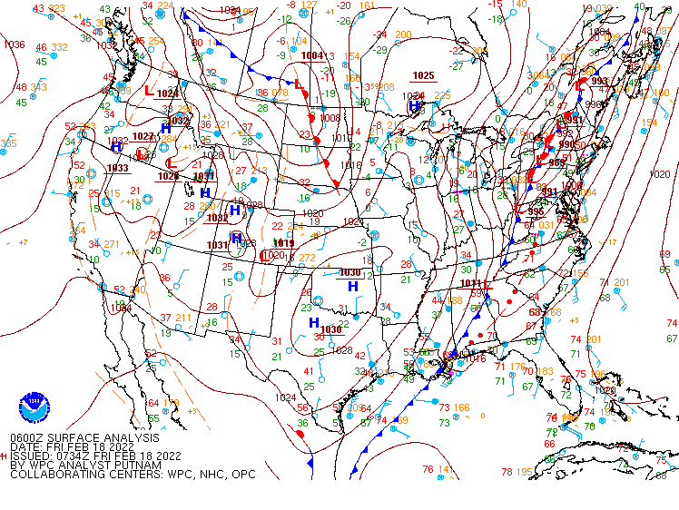
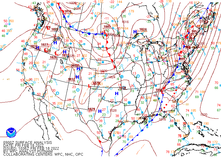
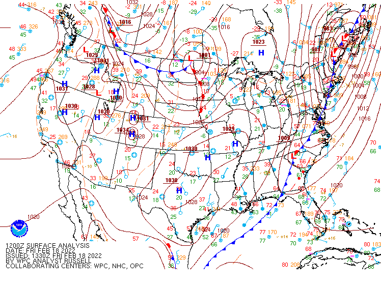
Surface Maps (courtesy of WPC)
 |
 |
 |
| Figure 13: 00z surface map | Figure 14: 03z surface map | Figure 15: 06z surface map |
 |
 |
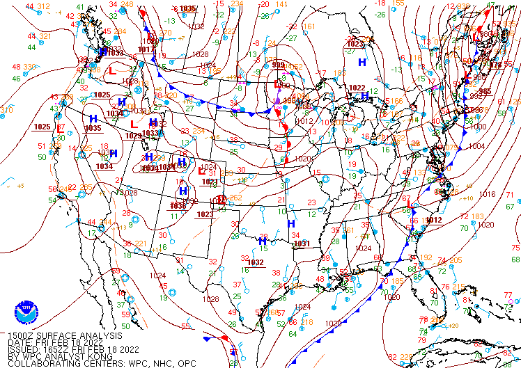 |
| Figure 16: 09z surface map | Figure 17: 12z surface map | Figure 18: 15z surface map |
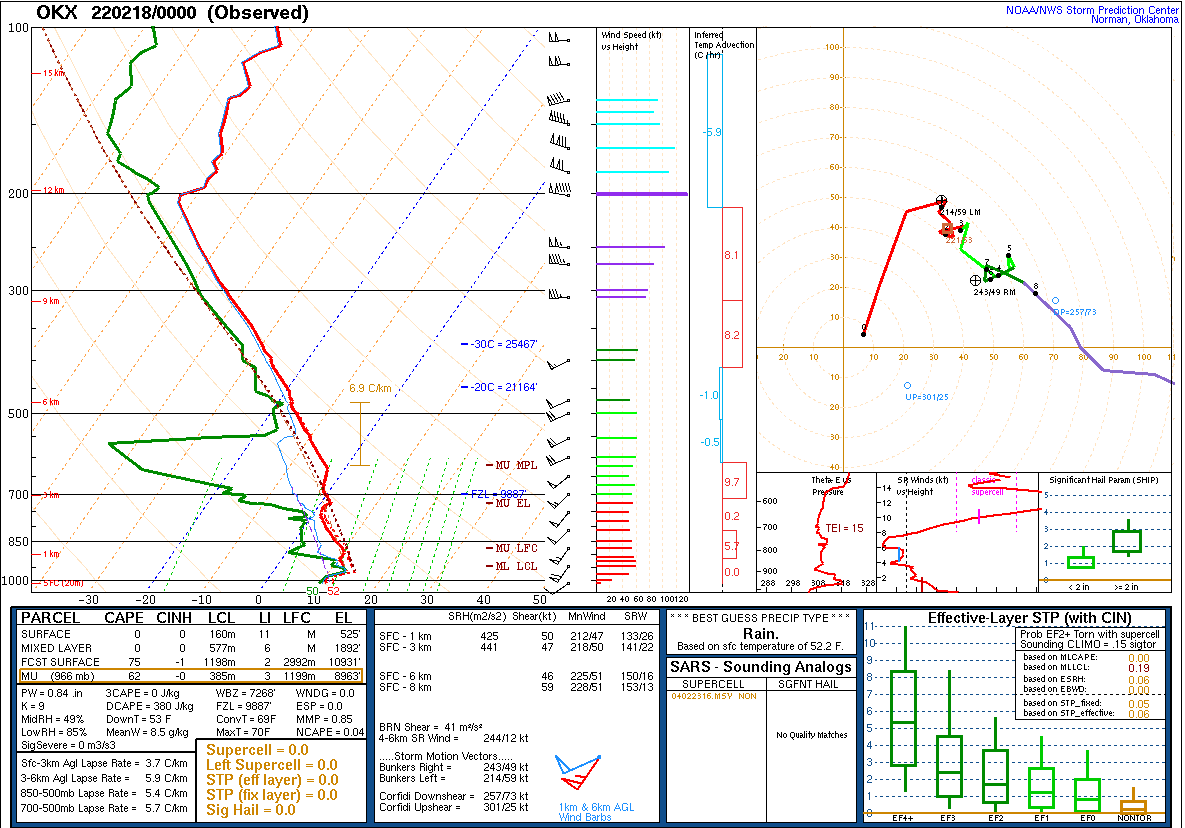 |
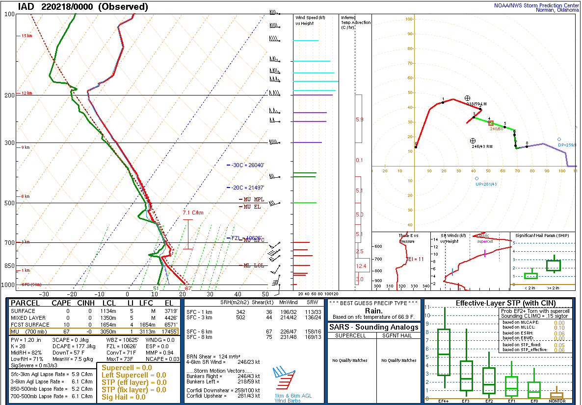 |
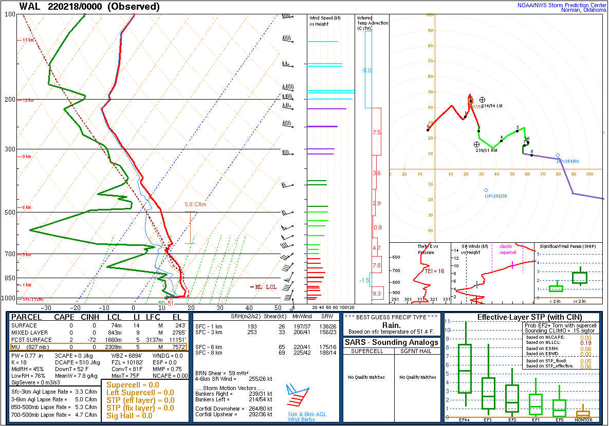 |
| Figure 19: 00z Long Island, NY sounding | Figure 20: 00z Sterling, VA sounding | Figure 21: 00z Wallops Island, VA sounding |
 |
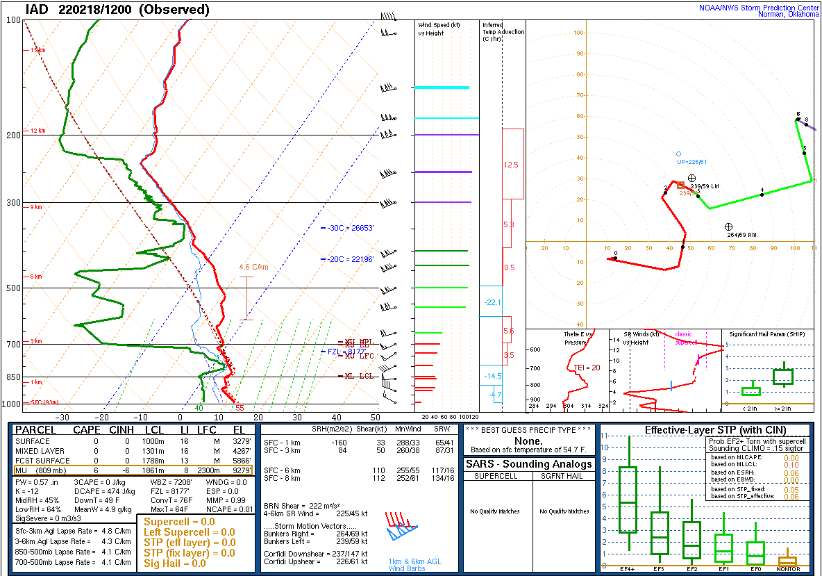 |
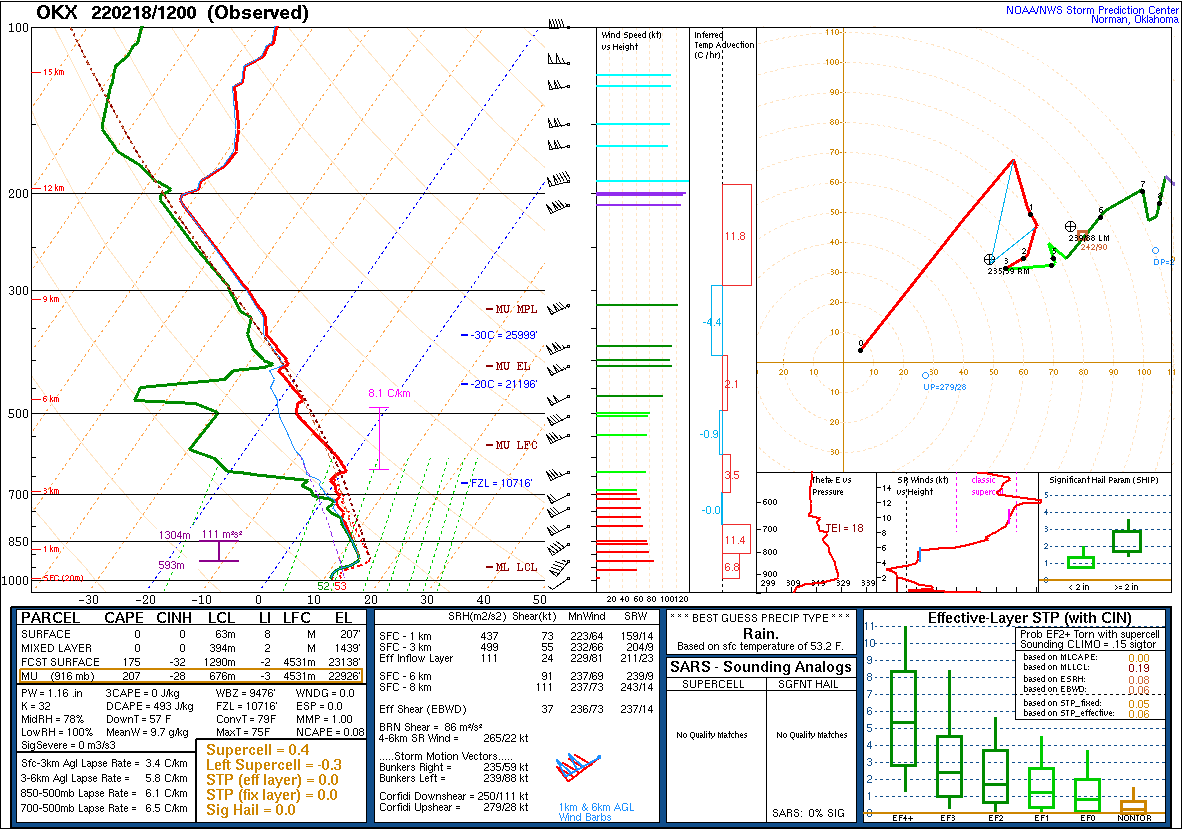
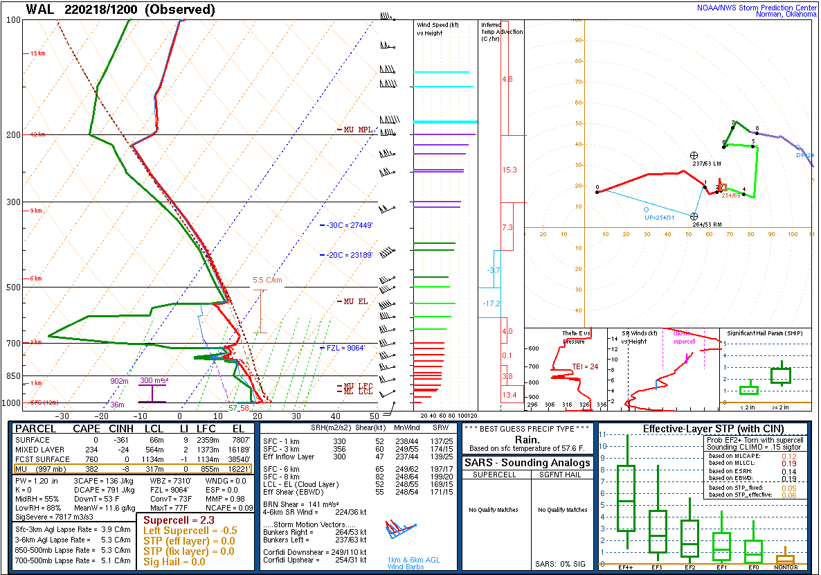 |
| Figure 22: 12z Long Island, NY sounding | Figure 23: 12z Sterling, VA sounding | Figure 24: 12z Wallops Island, VA sounding |
 |
 |
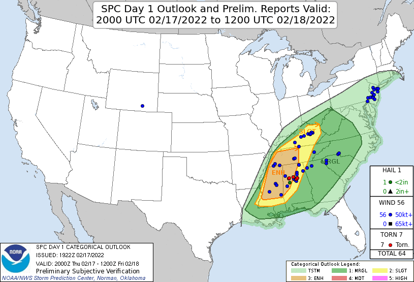 |
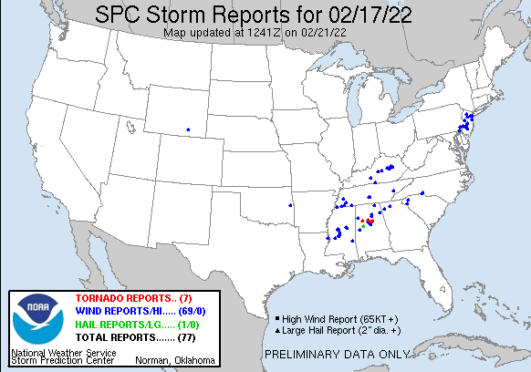
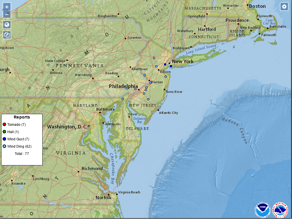
| Figure 1: National Preliminary Reports 12z 17 Feb 2022 to 12z 18 Feb 2022 | Figure 2: Zoomed Preliminary Reports for the same period. | Figure 3: Prelim Reports vs. 2000z SPC Convective Outlook |
Click here for a county warning area based plot of local storm reports and warnings/advisories issued for the 17-18 Feb 2022 event.
NWUS51 KPHI 181545
LSRPHI

PRELIMINARY LOCAL STORM REPORT...SUMMARY
NATIONAL WEATHER SERVICE MOUNT HOLLY NJ
1045 AM EST FRI FEB 18 2022

..TIME...   ...EVENT...      ...CITY LOCATION...     ...LAT.LON...
..DATE...   ....MAG....      ..COUNTY LOCATION..ST.. ...SOURCE....
            ..REMARKS..

0130 AM     NON-TSTM WND DMG 1 W MARLBORO            40.31N 74.26W
02/18/2022                   MONMOUTH           NJ   DEPT OF HIGHWAYS

            DOWNED TREE ON NJ-18 SOUTHBOUND NORTH OF
            NJ-79. THERE IS A LANE RESTRICTION.

0245 AM     NON-TSTM WND GST 1 SSW RUSCOMBMANOR TWP  40.41N 75.83W
02/18/2022  M66 MPH          BERKS              PA   MESONET

            MESONET STATION AS951 FLEETWOOD.

0315 AM     NON-TSTM WND GST HARVEY CEDARS           39.70N 74.14W
02/18/2022  M67 MPH          OCEAN              NJ   MESONET

            MESONET STATION NJ11 HARVEY CEDARS.

0315 AM     NON-TSTM WND DMG 1 SSE FOUNTAIN HILL     40.60N 75.39W
02/18/2022                   NORTHAMPTON        PA   DEPT OF HIGHWAYS

            DOWNED TREE IN WIRES ON PA-378.

0320 AM     NON-TSTM WND DMG NORTH COVENTRY TWP      40.23N 75.66W
02/18/2022                   CHESTER            PA   DEPT OF HIGHWAYS

            DOWNED TREE ON PA-100 BETWEEN PA-724 AND
            CEDARVILLE RD. THERE IS A LANE RESTRICTION.

0330 AM     NON-TSTM WND DMG 1 SE BREINIGSVILLE      40.53N 75.62W
02/18/2022                   LEHIGH             PA   DEPT OF HIGHWAYS

            DOWNED TREE ON MERTZTOWN RD AT LOCUST LN.

0330 AM     NON-TSTM WND DMG 1 SE TROOPER            40.14N 75.39W
02/18/2022                   MONTGOMERY         PA   TRAINED SPOTTER

            TREE DOWN ON WIRES ON TROOPER ROAD AND
            OAKDALE AVENUE.

0445 AM     NON-TSTM WND DMG OAKS                    40.13N 75.45W
02/18/2022                   MONTGOMERY         PA   TRAINED SPOTTER

            TREE DOWN ON EGYPT ROAD AT CIDER MILL ROAD.

0500 AM     NON-TSTM WND DMG 3 E EASTON              38.77N 76.02W
02/18/2022                   TALBOT             MD   DEPT OF HIGHWAYS

            MD-331 CLOSED AT BLACK DOG ALLEY DUE TO
            DOWNED TREES AND/OR WIRES.

0500 AM     NON-TSTM WND DMG 1 SE EMMAUS             40.53N 75.48W
02/18/2022                   LEHIGH             PA   UTILITY COMPANY

            POWER OUTAGES REPORTED DUE TO LIMBS ON
            WIRES.

0530 AM     NON-TSTM WND DMG 2 SE FREEHOLD TWP       40.22N 74.27W
02/18/2022                   MONMOUTH           NJ   DEPT OF HIGHWAYS

            DOWNED TREE ON US-9 NORTHBOUND EXIT RAMP
            SOUTH OF CR 524/ELTON-ADELPHIA RD. ALL LANES
            CLOSED.

0530 AM     TSTM WND DMG     2 N WEST CHESTER        39.99N 75.60W
02/18/2022                   CHESTER            PA   DEPT OF HIGHWAYS

            TREE DOWN AT GOSHEN ROAD. TIME ESTIMATED
            FROM RADAR.

0545 AM     TSTM WND DMG     NEWARK                  39.68N 75.76W
02/18/2022                   NEW CASTLE         DE   TRAINED SPOTTER

            SEVERAL TREES DOWN AROUND NEWARK. TIME
            ESTIMATED FROM RADAR.

0545 AM     TSTM WND DMG     1 ENE LAMBERTVILLE      40.37N 74.93W
02/18/2022                   HUNTERDON          NJ   UTILITY COMPANY

            POWER OUTAGES REPORTED DUE TO TREE DAMAGE.

0549 AM     NON-TSTM WND GST 1 E BARNEGAT LIGHT      39.76N 74.09W
02/18/2022  M69 MPH          ANZ451             NJ   MESONET

            BARNEGAT INLET LIGHT 7 (XBRN) REPORTED A
            GUST OF 69 MPH.

0550 AM     TSTM WND DMG     1 N RANDOLPH            40.86N 74.58W
02/18/2022                   MORRIS             NJ   DEPT OF HIGHWAYS

            TREE DOWN ON NJ 10, PARTIALLY BLOCKING THE
            ROADWAY. TIME ESTIMATED FROM RADAR.

0600 AM     TSTM WND DMG     WARREN                  40.62N 74.49W
02/18/2022                   SOMERSET           NJ   TRAINED SPOTTER

            MULTIPLE LARGE BRANCHES DOWN AND POWER
            OUTAGES. TIME ESTIMATED FROM RADAR.

0605 AM     TSTM WND DMG     1 SSW PENN WYNNE        39.97N 75.29W
02/18/2022                   DELAWARE           PA   PUBLIC

            TREE REPORTED DOWN OVER US 1 IN HAVERFORD
            TWP. TIME ESTIMATED FROM RADAR. REPORT VIA
            SOCIAL MEDIA.

0605 AM     NON-TSTM WND GST 1 SSE SOUTH PHILADELPHI 39.89N 75.20W
02/18/2022  M59 MPH          PHILADELPHIA       PA   MESONET

            MESONET STATION 11378 I-95 @ GIRARD AVENUE.

0615 AM     TSTM WND DMG     RANCOCAS                40.02N 74.87W
02/18/2022                   BURLINGTON         NJ   UTILITY COMPANY

            POWER OUTAGES REPORTED DUE TO TREE DAMAGE.

0618 AM     TSTM WND DMG     MOUNT LAUREL            39.94N 74.89W
02/18/2022                   BURLINGTON         NJ   PUBLIC

            SEVERAL BRANCHES AND A FEW LARGE LIMBS DOWN.
            TIME ESTIMATED FROM RADAR.

0620 AM     TSTM WND DMG     BORDENTOWN              40.15N 74.71W
02/18/2022                   BURLINGTON         NJ   PUBLIC

            VERY LARGE LIMB SNAPPED. TIME ESTIMATED FROM
            RADAR.

0620 AM     TSTM WND DMG     GIBBSBORO               39.84N 74.96W
02/18/2022                   CAMDEN             NJ   UTILITY COMPANY

            POWER OUTAGES REPORTED DUE TO WINDS. TIME
            ESTIMATED FROM RADAR.

0621 AM     NON-TSTM WND GST 4 SE MYSTIC ISLAND      39.52N 74.32W
02/18/2022  M64 MPH          OCEAN              NJ   MESONET

            MESONET STATION XTUK TUCKERTON.

0630 AM     NON-TSTM WND DMG 2 NNW WILSON            40.71N 75.25W
02/18/2022                   NORTHAMPTON        PA   PUBLIC

            SEVERAL LARGE BRANCHES SNAPPED. TIME
            ESTIMATED FROM NEARBY OBSERVATIONS.

0645 AM     TSTM WND DMG     2 N HAMMONTON           39.67N 74.80W
02/18/2022                   ATLANTIC           NJ   UTILITY COMPANY

            POWER OUTAGES REPORTED DUE TO HIGH WINDS.
            TIME ESTIMATED FROM RADAR.

0700 AM     NON-TSTM WND DMG 2 NNE ROBESON TWP       40.26N 75.86W
02/18/2022                   BERKS              PA   UTILITY COMPANY

            POWER OUTAGES REPORTED DUE TO LIMBS ON
            WIRES. TIME ESTIMATED.

0700 AM     NON-TSTM WND DMG 1 SSE FOUNTAIN HILL     40.60N 75.39W
02/18/2022                   NORTHAMPTON        PA   NEWSPAPER

            TREE AND WIRES DOWN CLOSING ROUTE 378. TIME
            ESTIMATED.

0705 AM     NON-TSTM WND GST HIGH POINT              41.32N 74.66W
02/18/2022  M66 MPH          SUSSEX             NJ   MESONET

            MESONET STATION NJ61 HIGH POINT MONUMENT.

0930 AM     NON-TSTM WND DMG LINCROFT                40.33N 74.14W
02/18/2022                   MONMOUTH           NJ   BROADCAST MEDIA

            CORRECTS PREVIOUS TSTM WND DMG REPORT FROM
            LINCROFT. LARGE TREE UPROOTED PARTIALLY ON A
            HOUSE IN LINCROFT. TIME UPDATED FROM FURTHER
            REPORTS. THIS OCCURRED AFTER THE LINE OF
            SHOWERS AND THUNDERSTORMS.


&&

$$
NOUS41 KPHI 181429 CCA
PNSPHI
DEZ001>004-MDZ012-015-019-020-NJZ001-007>010-012>027-PAZ054-055-060>062-070-
071-101>106-190227-

Public Information Statement
National Weather Service Mount Holly NJ
927 AM EST Fri Feb 18 2022

...HIGHEST WIND REPORTS...

Note: This includes both non-thunderstorm and thunderstorm related
wind gusts.

Location                     Speed     Time/Date       Provider

...Delaware...

...Kent County...
Dover                        54 MPH    0411 AM 02/18   AWOS
St. Jones River Dover        46 MPH    0450 AM 02/18   DEOS2
Delaware Airpark             45 MPH    0455 AM 02/18   MESOWEST
Dover Cheswold               45 MPH    0455 AM 02/18   AWOS
Clayton (WEATHERSTEM)        45 MPH    0630 AM 02/18   MESOWEST

...New Castle County...
Wilmington                   53 MPH    0555 AM 02/18   ASOS
Middletown                   48 MPH    0326 AM 02/18   CWOP

...Sussex County...
Greenwood                    54 MPH    0450 AM 02/18   CWOP
Dewey Beach                  52 MPH    0759 AM 02/18   WXFLOW
Georgetown                   51 MPH    0450 AM 02/18   ASOS
Seaford                      50 MPH    0450 AM 02/18   CWOP
Lewes                        49 MPH    0720 AM 02/18   WXFLOW
Lewes NOS                    48 MPH    0748 AM 02/18   NOS-NWLON
Deep Creek Georgetown        45 MPH    0600 AM 02/18   DEOS2

...New Jersey...

...Atlantic County...
Atlantic City                55 MPH    0535 AM 02/18   NJWXNET
Atlantic City                54 MPH    0710 AM 02/18   ASOS
Pleasantville Point          51 MPH    0417 AM 02/18   WXFLOW
Mullica Twp.                 49 MPH    0655 AM 02/18   NJWXNET

...Burlington County...
Moorestown                   51 MPH    0620 AM 02/18   NJWXNET
McGuire AFB                  48 MPH    0634 AM 02/18   AWOS

...Camden County...
Pennsauken                   54 MPH    0610 AM 02/18   NJWXNET

...Cape May County...
Ocean City                   54 MPH    0351 AM 02/18   WXFLOW
Cape May                     49 MPH    0729 AM 02/18   AWOS

...Cumberland County...
Millville                    51 MPH    0650 AM 02/18   ASOS
Fortesque                    45 MPH    0810 AM 02/18   NJWXNET

...Hunterdon County...
Pittstown                    45 MPH    0415 AM 02/18   NJWXNET

...Middlesex County...
Perth Amboy                  55 MPH    0628 AM 02/18   WXFLOW

...Monmouth County...
Keyport                      53 MPH    0645 AM 02/18   CWOP
N.Middletown                 50 MPH    0247 AM 02/18   CWOP
Sea Girt                     50 MPH    0700 AM 02/18   NJWXNET
Belmar Farmdale              47 MPH    0649 AM 02/18   AWOS
Monmouth                     46 MPH    0414 AM 02/18   WXFLOW

...Morris County...
Hopatcong                    46 MPH    0546 AM 02/18   CWOP

...Ocean County...
Harvey Cedars                67 MPH    0315 AM 02/18   NJWXNET
Tuckerton                    64 MPH    0621 AM 02/18   WXFLOW
Rutgers                      57 MPH    0415 AM 02/18   WXFLOW
Seaside Heights              52 MPH    0315 AM 02/18   WXFLOW
Island Heights               51 MPH    0430 AM 02/18   CWOP
Lakehurst NAS                49 MPH    0606 AM 02/18   AWOS
Berkeley Twp.                47 MPH    0315 AM 02/18   NJWXNET
South Seaside Park           46 MPH    0546 AM 02/18   CWOP
Mantoloking                  46 MPH    0805 AM 02/18   WXFLOW
Beach Haven                  46 MPH    0856 AM 02/18   CWOP

...Salem County...
Mannington Twp.              46 MPH    0615 AM 02/18   NJWXNET

...Sussex County...
High Point Monument          66 MPH    0705 AM 02/18   NJWXNET
High Point                   48 MPH    1250 AM 02/18   NJWXNET

...Pennsylvania...

...Berks County...
Fleetwood                    66 MPH    0245 AM 02/18   CWOP
I-176 E/B @ SR 422 Interchan 51 MPH    0605 AM 02/18   PADOT
Mertztown                    49 MPH    0315 AM 02/18   CWOP
Reading                      48 MPH    0216 AM 02/18   ASOS
I-78 W B @ Mm 27 Berks Co.   47 MPH    0535 AM 02/18   MESOWEST
I-78 W/B @ MM 27 Berks Co.   47 MPH    0535 AM 02/18   PADOT

...Bucks County...
Newbold NOS                  49 MPH    0618 AM 02/18   NOS-PORTS
Doylestown                   46 MPH    0350 AM 02/18   ASOS
Nockamixon                   46 MPH    0636 AM 02/18   WXFLOW
Burlington NOS               45 MPH    0700 AM 02/18   NOS-PORTS

...Chester County...
White Clay Creek West Grove- 53 MPH    0745 AM 02/18   DEOS2
Sr30 @ Business 30           51 MPH    0520 AM 02/18   MESOWEST
SR30 @ Business 30           51 MPH    0520 AM 02/18   PADOT
Cochranville                 47 MPH    0646 AM 02/18   CWOP
Brandywine Regional Airport  46 MPH    0535 AM 02/18   MESOWEST
West Chester                 46 MPH    0535 AM 02/18   AWOS

...Delaware County...
Upper Chichester             46 MPH    0645 AM 02/18   CWOP

...Lehigh County...
Queen City                   51 MPH    0515 AM 02/18   AWOS
Macungie                     47 MPH    0510 AM 02/18   CWOP
Lehigh Valley Intl Airport   46 MPH    0508 AM 02/18   ASOS

...Monroe County...
Mt. Pocono                   52 MPH    0319 AM 02/18   ASOS
SR33 & Wind Gap              49 MPH    0905 AM 02/18   PADOT

...Montgomery County...
Pottstown                    49 MPH    0640 AM 02/18   ASOS

...Northampton County...
Nazareth                     52 MPH    0515 AM 02/18   CWOP

...Philadelphia County...
I-95 @ Girard Avenue         59 MPH    0605 AM 02/18   PADOT
 null Philadelphia Internati 56 MPH    0605 AM 02/18   Other Federal
I-95 @ Girard Avenue         53 MPH    0735 AM 02/18   MESOWEST
Philadelphia Northeast       52 MPH    0612 AM 02/18   ASOS
Northeast Philadelphia Airpo 52 MPH    0612 AM 02/18   ASOS
Philadelphia International A 51 MPH    0408 AM 02/18   ASOS

...New Jersey...

...Maritime Stations...
1 E Barnegat Light           69 MPH    0549 AM 02/18   Mesonet
&&

**METADATA**
:2/18/2022,0455 AM, DE, Kent, Delaware Airpark, , , 39.2187, -75.6005, PKGUST, 45, mph, MESOWEST, Peak Wind Gust,
:2/18/2022,0455 AM, DE, Kent, Dover Cheswold, , , 39.2167, -75.6, PKGUST, 45, mph, AWOS, Peak Wind Gust,
:2/18/2022,0630 AM, DE, Kent, Clayton (WEATHERSTEM), , , 39.2917, -75.6343, PKGUST, 45, mph, MESOWEST, Peak Wind Gust,
:2/18/2022,0450 AM, DE, Kent, St. Jones River Dover, , , 39.1696, -75.593, PKGUST, 46, mph, DEOS2, Peak Wind Gust,
:2/18/2022,0411 AM, DE, Kent, Dover, , , 39.1167, -75.4667, PKGUST, 54, mph, AWOS, Peak Wind Gust,
:2/18/2022,0326 AM, DE, New Castle, Middletown, , , 39.4915, -75.6338, PKGUST, 48, mph, CWOP, Peak Wind Gust,
:2/18/2022,0555 AM, DE, New Castle, Wilmington, , , 39.6667, -75.6, PKGUST, 53, mph, ASOS, Peak Wind Gust,
:2/18/2022,0600 AM, DE, Sussex, Deep Creek Georgetown, , , 38.6361, -75.455, PKGUST, 45, mph, DEOS2, Peak Wind Gust,
:2/18/2022,0748 AM, DE, Sussex, Lewes NOS, , , 38.7817, -75.12, PKGUST, 48, mph, NOS-NWLON, Peak Wind Gust,
:2/18/2022,0720 AM, DE, Sussex, Lewes, , , 38.7891, -75.1582, PKGUST, 49, mph, WXFLOW, Peak Wind Gust,
:2/18/2022,0450 AM, DE, Sussex, Seaford, , , 38.645, -75.6261, PKGUST, 50, mph, CWOP, Peak Wind Gust,
:2/18/2022,0450 AM, DE, Sussex, Georgetown, , , 38.6833, -75.3667, PKGUST, 51, mph, ASOS, Peak Wind Gust,
:2/18/2022,0759 AM, DE, Sussex, Dewey Beach, , , 38.6813, -75.0751, PKGUST, 52, mph, WXFLOW, Peak Wind Gust,
:2/18/2022,0450 AM, DE, Sussex, Greenwood, , , 38.7785, -75.5823, PKGUST, 54, mph, CWOP, Peak Wind Gust,
:2/18/2022,0655 AM, NJ, Atlantic, Mullica Twp., , , 39.5498, -74.733, PKGUST, 49, mph, NJWXNET, Peak Wind Gust,
:2/18/2022,0417 AM, NJ, Atlantic, Pleasantville Point, , , 39.3734, -74.4955, PKGUST, 51, mph, WXFLOW, Peak Wind Gust,
:2/18/2022,0710 AM, NJ, Atlantic, Atlantic City, , , 39.45, -74.5667, PKGUST, 54, mph, ASOS, Peak Wind Gust,
:2/18/2022,0535 AM, NJ, Atlantic, Atlantic City, , , 39.3785, -74.4242, PKGUST, 55, mph, NJWXNET, Peak Wind Gust,
:2/18/2022,0634 AM, NJ, Burlington, McGuire AFB, , , 40.0167, -74.5833, PKGUST, 48, mph, AWOS, Peak Wind Gust,
:2/18/2022,0620 AM, NJ, Burlington, Moorestown, , , 39.9833, -74.8957, PKGUST, 51, mph, NJWXNET, Peak Wind Gust,
:2/18/2022,0610 AM, NJ, Camden, Pennsauken, , , 39.9851, -75.0391, PKGUST, 54, mph, NJWXNET, Peak Wind Gust,
:2/18/2022,0729 AM, NJ, Cape May, Cape May, , , 39.2635, -74.6075, PKGUST, 49, mph, AWOS, Peak Wind Gust,
:2/18/2022,0351 AM, NJ, Cape May, Ocean City, , , 39.2191, -74.6381, PKGUST, 54, mph, WXFLOW, Peak Wind Gust,
:2/18/2022,0810 AM, NJ, Cumberland, Fortesque, , , 39.2425, -75.177, PKGUST, 45, mph, NJWXNET, Peak Wind Gust,
:2/18/2022,0650 AM, NJ, Cumberland, Millville, , , 39.3667, -75.0833, PKGUST, 51, mph, ASOS, Peak Wind Gust,
:2/18/2022,0415 AM, NJ, Hunterdon, Pittstown, , , 40.5612, -74.961, PKGUST, 45, mph, NJWXNET, Peak Wind Gust,
:2/18/2022,0628 AM, NJ, Middlesex, Perth Amboy, , , 40.5013, -74.2837, PKGUST, 55, mph, WXFLOW, Peak Wind Gust,
:2/18/2022,0414 AM, NJ, Monmouth, Monmouth, , , 40.3365, -73.9923, PKGUST, 46, mph, WXFLOW, Peak Wind Gust,
:2/18/2022,0649 AM, NJ, Monmouth, Belmar Farmdale, , , 40.1667, -74.1167, PKGUST, 47, mph, AWOS, Peak Wind Gust,
:2/18/2022,0247 AM, NJ, Monmouth, N.Middletown, , , 40.44, -74.1125, PKGUST, 50, mph, CWOP, Peak Wind Gust,
:2/18/2022,0700 AM, NJ, Monmouth, Sea Girt, , , 40.1204, -74.0328, PKGUST, 50, mph, NJWXNET, Peak Wind Gust,
:2/18/2022,0645 AM, NJ, Monmouth, Keyport, , , 40.4397, -74.1975, PKGUST, 53, mph, CWOP, Peak Wind Gust,
:2/18/2022,0546 AM, NJ, Morris, Hopatcong, , , 40.9652, -74.6047, PKGUST, 46, mph, CWOP, Peak Wind Gust,
:2/18/2022,0546 AM, NJ, Ocean, South Seaside Park, , , 39.9094, -74.0812, PKGUST, 46, mph, CWOP, Peak Wind Gust,
:2/18/2022,0805 AM, NJ, Ocean, Mantoloking, , , 40.0096, -74.059, PKGUST, 46, mph, WXFLOW, Peak Wind Gust,
:2/18/2022,0856 AM, NJ, Ocean, Beach Haven, , , 39.5447, -74.2555, PKGUST, 46, mph, CWOP, Peak Wind Gust,
:2/18/2022,0315 AM, NJ, Ocean, Berkeley Twp., , , 39.9258, -74.2982, PKGUST, 47, mph, NJWXNET, Peak Wind Gust,
:2/18/2022,0606 AM, NJ, Ocean, Lakehurst NAS, , , 40.0167, -74.3333, PKGUST, 49, mph, AWOS, Peak Wind Gust,
:2/18/2022,0430 AM, NJ, Ocean, Island Heights, , , 39.94, -74.1451, PKGUST, 51, mph, CWOP, Peak Wind Gust,
:2/18/2022,0315 AM, NJ, Ocean, Seaside Heights, , , 39.94, -74.0708, PKGUST, 52, mph, WXFLOW, Peak Wind Gust,
:2/18/2022,0415 AM, NJ, Ocean, Rutgers, , , 39.5216, -74.3191, PKGUST, 57, mph, WXFLOW, Peak Wind Gust,
:2/18/2022,0621 AM, NJ, Ocean, Tuckerton, , , 39.5218, -74.3191, PKGUST, 64, mph, WXFLOW, Peak Wind Gust,
:2/18/2022,0315 AM, NJ, Ocean, Harvey Cedars, , , 39.705, -74.1352, PKGUST, 67, mph, NJWXNET, Peak Wind Gust,
:2/18/2022,0615 AM, NJ, Salem, Mannington Twp., , , 39.6294, -75.3592, PKGUST, 46, mph, NJWXNET, Peak Wind Gust,
:2/18/2022,1250 AM, NJ, Sussex, High Point, , , 41.305, -74.666, PKGUST, 48, mph, NJWXNET, Peak Wind Gust,
:2/18/2022,0705 AM, NJ, Sussex, High Point Monument, , , 41.3217, -74.6607, PKGUST, 66, mph, NJWXNET, Peak Wind Gust,
:2/18/2022,0535 AM, PA, Berks, I-78 W B @ Mm 27 Berks Co., , , 40.5427, -76.0364, PKGUST, 47, mph, MESOWEST, Peak Wind Gust,
:2/18/2022,0535 AM, PA, Berks, I-78 W/B @ MM 27 Berks Co., , , 40.5427, -76.0364, PKGUST, 47, mph, PADOT, Peak Wind Gust,
:2/18/2022,0216 AM, PA, Berks, Reading, , , 40.3667, -75.9667, PKGUST, 48, mph, ASOS, Peak Wind Gust,
:2/18/2022,0315 AM, PA, Berks, Mertztown, , , 40.5057, -75.6653, PKGUST, 49, mph, CWOP, Peak Wind Gust,
:2/18/2022,0605 AM, PA, Berks, I-176 E/B @ SR 422 Interchange Berks Co., , , 40.3014, -75.9005, PKGUST, 51, mph, PADOT, Peak Wind Gust,
:2/18/2022,0245 AM, PA, Berks, Fleetwood, , , 40.4135, -75.8313, PKGUST, 66, mph, CWOP, Peak Wind Gust,
:2/18/2022,0700 AM, PA, Bucks, Burlington NOS, , , 40.0817, -74.8697, PKGUST, 45, mph, NOS-PORTS, Peak Wind Gust,
:2/18/2022,0350 AM, PA, Bucks, Doylestown, , , 40.3333, -75.1167, PKGUST, 46, mph, ASOS, Peak Wind Gust,
:2/18/2022,0636 AM, PA, Bucks, Nockamixon, , , 40.4671, -75.2222, PKGUST, 46, mph, WXFLOW, Peak Wind Gust,
:2/18/2022,0618 AM, PA, Bucks, Newbold NOS, , , 40.1367, -74.7517, PKGUST, 49, mph, NOS-PORTS, Peak Wind Gust,
:2/18/2022,0535 AM, PA, Chester, Brandywine Regional Airport, , , 39.9901, -75.5819, PKGUST, 46, mph, MESOWEST, Peak Wind Gust,
:2/18/2022,0535 AM, PA, Chester, West Chester, , , 39.9833, -75.5833, PKGUST, 46, mph, AWOS, Peak Wind Gust,
:2/18/2022,0646 AM, PA, Chester, Cochranville, , , 39.8368, -75.8768, PKGUST, 47, mph, CWOP, Peak Wind Gust,
:2/18/2022,0520 AM, PA, Chester, Sr30 @ Business 30, , , 39.9823, -75.9222, PKGUST, 51, mph, MESOWEST, Peak Wind Gust,
:2/18/2022,0520 AM, PA, Chester, SR30 @ Business 30, , , 39.9823, -75.9222, PKGUST, 51, mph, PADOT, Peak Wind Gust,
:2/18/2022,0745 AM, PA, Chester, White Clay Creek West Grove-SECCRA, , , 39.8656, -75.8464, PKGUST, 53, mph, DEOS2, Peak Wind Gust,
:2/18/2022,0645 AM, PA, Delaware, Upper Chichester, , , 39.8317, -75.4345, PKGUST, 46, mph, CWOP, Peak Wind Gust,
:2/18/2022,0508 AM, PA, Lehigh, Lehigh Valley Intl Airport, , , 40.65, -75.45, PKGUST, 46, mph, ASOS, Peak Wind Gust,
:2/18/2022,0510 AM, PA, Lehigh, Macungie, , , 40.5095, -75.5441, PKGUST, 47, mph, CWOP, Peak Wind Gust,
:2/18/2022,0515 AM, PA, Lehigh, Queen City, , , 40.5667, -75.4833, PKGUST, 51, mph, AWOS, Peak Wind Gust,
:2/18/2022,0905 AM, PA, Monroe, SR33 & Wind Gap, , , 40.8622, -75.295, PKGUST, 49, mph, PADOT, Peak Wind Gust,
:2/18/2022,0319 AM, PA, Monroe, Mt. Pocono, , , 41.1333, -75.3833, PKGUST, 52, mph, ASOS, Peak Wind Gust,
:2/18/2022,0640 AM, PA, Montgomery, Pottstown, , , 40.2333, -75.55, PKGUST, 49, mph, ASOS, Peak Wind Gust,
:2/18/2022,0515 AM, PA, Northampton, Nazareth, , , 40.7363, -75.351, PKGUST, 52, mph, CWOP, Peak Wind Gust,
:2/18/2022,0408 AM, PA, Philadelphia, Philadelphia International Airport, , , 39.8784, -75.2257, PKGUST, 51, mph, ASOS, Peak Wind Gust,
:2/18/2022,0612 AM, PA, Philadelphia, Philadelphia Northeast, , , 40.0833, -75.0166, PKGUST, 52, mph, ASOS, Peak Wind Gust,
:2/18/2022,0612 AM, PA, Philadelphia, Northeast Philadelphia Airport, , , 40.081804379981, -75.012407003936, PKGUST, 52, mph, ASOS, Peak Wind Gust,
:2/18/2022,0735 AM, PA, Philadelphia, I-95 @ Girard Avenue, , , 39.8914, -75.1991, PKGUST, 53, mph, MESOWEST, Peak Wind Gust,
:2/18/2022,0605 AM, PA, Philadelphia,  null Philadelphia International Airport, , , 39.877491019808, -75.224837957915, PKGUST, 56, mph, Other Federal, Peak Wind Gust,
:2/18/2022,0605 AM, PA, Philadelphia, I-95 @ Girard Avenue, , , 39.8914, -75.1991, PKGUST, 59, mph, PADOT, Peak Wind Gust,

Observations are collected from a variety of sources with varying
equipment and exposures. We thank all volunteer weather observers
for their dedication. Not all data listed are considered official.

$$


 Coastal Flood
 Marine Forecasts
 Text Products
 Climate Information
 Skywarn
 Submit Storm Report
 Weather Event Archives
 Forecast Discussion
 Emergency Managers
 Briefing Page