Overview
|
A strong storm affected the mid-Atlantic and much of the Eastern Seaboard from January 16-17, 2022. A strong negative tilt trough over the Southeast US spurred strong cyclogenesis near the Carolina coast late on January 16. This low would proceed to quickly deepen as it moved northward that evening and night. Upper level steering patterns caused the low to take an “inside runner” track which kept the low center inland of the coast. A very strong easterly low level jet developed in between the strengthening low and a departing high pressure center to the north. With the center of the low tracking west of the region and an influx of marine air courtesy of the low level jet, precipitation type was a major forecast challenge in this event. An Arctic air mass had been in place in advance of this system, but due to the aforementioned factors, that air mass rapidly modified on the 16th. As precipitation arrived, temperatures remained cold enough for it to begin as snow in most areas away from the coast. However, a rapid transition from snow to mixed precipitation to rain occurred in most areas within hours. Frozen precipitation held on for longer across the interior, where some higher snowfall amounts occurred (see the map to the right or the snowfall reports tab). As the low center passed just to our west and began to occlude, an occluded front moved through the region. As this happened, an area of heavier precipitation with embedded convective elements moved through eastern New Jersey and the coastal waters. This convection allowed for some local enhancement of downward momentum transport near the coast. With extremely strong winds present aloft, this led to some locally damaging convective wind gusts. With the strong onshore flow and a full moon occurring on the 17th, coastal flooding was also a significant factor in this event, and is discussed more under the Coastal Flooding tab. All in all, this was a highly dynamic storm with an unusually wide variety of hazard types. Various aspects of the storm are covered throughout this page. Information here should be considered preliminary, and this page may continue to be updated with additional information.
|
 Map of snowfall reports for the January 16-17, 2022 event, courtesy of the NWS Eastern Region Headquarters office. This system brought accumulating snow to much of the interior eastern US. |
Synoptic Overview at 00z 17 Jan 2022 (courtesy of SPC)
 |
 |
 |
| Figure 1: 250-mb analysis | Figure 2: 300-mb analysis | Figure 3: 500-mb analysis |
 |
 |
 |
| Figure 4: 700-mb analysis | Figure 5: 850-mb analysis | Figure 6: 925-mb analysis |
Synoptic Overview at 12z 17 Jan 2022 (courtesy of SPC)
 |
 |
 |
| Figure 7: 250-mb analysis | Figure 8: 300-mb analysis | Figure 9: 500-mb analysis |
 |
 |
 |
| Figure 10: 700-mb analysis | Figure 11: 850-mb analysis | Figure 12: 925-mb analysis |
Surface Maps (courtesy of WPC)
 |
 |
 |
| Figure 13: 00z surface map | Figure 14: 03z surface map | Figure 15: 06z surface map |
 |
 |
 |
| Figure 16: 09z surface map | Figure 17: 12z surface map | Figure 18: 15z surface map |
Observed Soundings (Courtesy of SPC)
 |
 |
 |
| Figure 19: Long Island, NY sounding from 00z January 17. | Figure 20: Sterling, VA sounding from 00z January 17. | Figure 21: Wallops Island, VA sounding from 00z January 17. |
 |
 |
 |
| Figure 22: Long Island, NY sounding from 12z January 17. | Figure 23: Sterling, VA sounding from 12z January 17. | Figure 24: Wallops Island, VA sounding from 12z January 17. |
Click here for a county warning area based plot of local storm reports and warnings/advisories issued for the 16-17 January 2022 event.
NOUS41 KPHI 171843
PNSPHI
DEZ001>004-MDZ012-015-019-020-NJZ001-007>010-012>027-PAZ054-055-060>062-070-
071-101>106-180643-

Public Information Statement
National Weather Service Mount Holly NJ
143 PM EST Mon Jan 17 2022

...SNOWFALL REPORTS...

Location                     Amount    Time/Date       Provider

...Delaware...

...Kent County...
Smyrna                       0.8 in    0600 PM 01/16   Trained Spotter
3 SW Magnolia                0.5 in    0530 PM 01/16   Trained Spotter
Smyrna                       0.4 in    1200 AM 01/17   Mesonet

...New Castle County...
Newark                       2.0 in    0710 PM 01/16   Cocorahs
Hockessin                    1.7 in    0810 PM 01/16   Trained Spotter
Hockessin                    1.1 in    1200 AM 01/17   Mesonet
Talley                       1.0 in    1200 AM 01/17   Mesonet
New Castle County Airport    1.0 in    0700 AM 01/17   ASOS
Claymont                     0.9 in    1200 AM 01/17   Mesonet
3 WNW Saint Georges          0.8 in    0600 PM 01/16   Public
Middletown                   0.8 in    0650 PM 01/16   Trained Spotter
White Clay Creek             0.8 in    1200 AM 01/17   Mesonet
Greenville                   0.7 in    1200 AM 01/17   Mesonet
Glasgow                      0.7 in    1200 AM 01/17   Mesonet
Newark                       0.7 in    1200 AM 01/17   Mesonet
Blackbird                    0.6 in    1200 AM 01/17   Mesonet
New Castle                   0.6 in    1200 AM 01/17   Mesonet
Prices Corner                0.5 in    1200 AM 01/17   Mesonet

...Maryland...

...Kent County...
Galena                       2.2 in    0730 PM 01/16   Public

...Queen Annes County...
Stevensville                 0.7 in    0700 PM 01/16   Trained Spotter

...Talbot County...
Easton                       0.5 in    0400 PM 01/16   Public

...New Jersey...

...Burlington County...
Delran                       0.7 in    0700 PM 01/16   Public
Florence                     0.5 in    1122 AM 01/17   Trained Spotter
1 WNW South Jersey Regional  0.4 in    0730 PM 01/16   NWS Employee
2 NNW South Jersey Regional  0.4 in    0740 PM 01/16   CO-OP Observer
Mount Holly WFO              0.2 in    0700 PM 01/16   Official NWS Obs

...Camden County...
Bellmawr                     0.4 in    0730 PM 01/16   Trained Spotter

...Gloucester County...
Thorofare                    0.8 in    0730 PM 01/16   Public
Sewell                       0.3 in    0645 PM 01/16   Trained Spotter

...Hunterdon County...
Annandale                    5.0 in    1100 PM 01/16   Public
Lebanon                      3.1 in    1030 PM 01/16   Trained Spotter
Stanton                      2.4 in    1015 PM 01/16   Trained Spotter
Flemington                   2.1 in    0950 PM 01/16   Trained Spotter
2 SSE Stanton                1.5 in    0910 PM 01/16   Trained Spotter

...Mercer County...
Hopewell                     2.3 in    0910 PM 01/16   Public
Woodsville                   1.4 in    0900 PM 01/16   Public
1 NE Hamilton Square         0.5 in    0800 PM 01/16   Trained Spotter
Ewing                        0.5 in    0845 PM 01/16   Trained Spotter

...Middlesex County...
Hopelawn                     1.0 in    0900 PM 01/16   Trained Spotter
North Brunswick              0.8 in    0845 PM 01/16   Public
Metuchen                     0.8 in    0900 AM 01/17   Public

...Morris County...
Green Pond                   5.5 in    1031 AM 01/17   Trained Spotter
Lake Hopatcong               4.8 in    0430 AM 01/17   Trained Spotter
Butler                       4.3 in    0100 AM 01/17   Trained Spotter
Budd Lake                    3.6 in    1230 AM 01/17   Public
2 NNE Brookside              3.5 in    1219 AM 01/17   Trained Spotter
Montville                    3.5 in    1230 AM 01/17   Trained Spotter
Succasunna                   3.4 in    1130 PM 01/16   Public
Randolph                     3.2 in    1130 PM 01/16   Cocorahs
2 ESE Morris Plains          3.0 in    1033 PM 01/16   Trained Spotter
Boonton                      2.9 in    1125 PM 01/16   Broadcast Media
Chatham                      2.3 in    1035 PM 01/16   Public
Randolph                     2.3 in    1100 PM 01/16   Public
Denville                     2.2 in    0500 AM 01/17   Trained Spotter

...Salem County...
Pennsville                   1.0 in    0815 PM 01/16   Fire Dept/Rescue

...Somerset County...
3 N Bridgewater              2.4 in    1000 PM 01/16   Trained Spotter
Warren                       2.3 in    1030 PM 01/16   Public
2 N Bridgewater              2.2 in    1045 PM 01/16   Trained Spotter
Bridgewater                  2.0 in    1015 PM 01/16   Trained Spotter
Bernardsville                0.5 in    0750 PM 01/16   Trained Spotter
Middlebush                   0.5 in    0935 PM 01/16   Public

...Sussex County...
Wantage Twp                  7.0 in    0700 AM 01/17   Public
High Point                   6.0 in    1035 AM 01/17   Public
4 WSW Wantage Twp            5.7 in    0615 AM 01/17   Trained Spotter
3 W Vernon Valley            5.5 in    0120 AM 01/17   Trained Spotter
Hardyston Twp                1.5 in    0845 PM 01/16   Public

...Warren County...
Hackettstown                 3.8 in    1125 PM 01/16   Trained Spotter
Oxford                       3.3 in    1030 PM 01/16   Trained Spotter
Blairstown                   2.5 in    1045 PM 01/16   Public
Allamuchy-Panther Valley     2.0 in    0930 PM 01/16   Public

...Pennsylvania...

...Berks County...
Huffs Church                 3.7 in    1036 AM 01/17   Public
Huffs Church                 3.5 in    0945 PM 01/16   Trained Spotter
Mertztown                    3.5 in    1000 PM 01/16   Trained Spotter
Bern Twp                     3.5 in    1010 PM 01/16   Trained Spotter
Spring Twp                   3.4 in    0945 PM 01/16   Public
Shillington                  3.3 in    1000 PM 01/16   Trained Spotter
Wernersville                 3.3 in    1015 PM 01/16   Trained Spotter
Wyomissing                   3.0 in    0945 PM 01/16   Public
1 WNW Sinking Spring         3.0 in    0945 PM 01/16   Public
Douglassville                2.5 in    0930 PM 01/16   Trained Spotter
Morgantown                   1.9 in    0810 PM 01/16   Public
Bechtelsville                1.9 in    0830 PM 01/16   Public

...Bucks County...
2 NE Springtown              4.0 in    1015 PM 01/16   CO-OP Observer
Chalfont                     2.7 in    0915 PM 01/16   Public
Doylestown                   2.5 in    0920 PM 01/16   Public
Buckingham Twp               2.3 in    0945 PM 01/16   Trained Spotter
Furlong                      2.2 in    0925 PM 01/16   Trained Spotter
Hilltown Twp                 2.0 in    0900 PM 01/16   Trained Spotter
Trumbauersville              2.0 in    0940 PM 01/16   Trained Spotter
2 NW New Britain             1.9 in    0900 PM 01/16   Trained Spotter
Warminster                   1.5 in    0830 PM 01/16   Trained Spotter
Jamison                      1.5 in    0900 PM 01/16   Public

...Carbon County...
Lehighton                    5.2 in    0105 AM 01/17   Public
Lower Towamensing Twp        3.5 in    1115 PM 01/16   Trained Spotter

...Chester County...
Elverson                     2.9 in    1000 PM 01/16   Trained Spotter
Malvern                      2.6 in    0829 PM 01/16   Public
East Coventry Twp            2.6 in    0850 PM 01/16   Trained Spotter
West Caln Twp                2.6 in    0950 PM 01/16   Trained Spotter
Spring City                  2.5 in    0850 PM 01/16   Trained Spotter
Phoenixville                 2.3 in    0855 PM 01/16   Trained Spotter
East Nantmeal Twp            2.3 in    0900 PM 01/16   Trained Spotter
2 NW Wayne                   2.0 in    0830 PM 01/16   Trained Spotter
2 W Phoenixville             2.0 in    0840 PM 01/16   Public
Glenmoore                    2.0 in    1057 PM 01/16   Trained Spotter
Glenmoore                    2.0 in    1200 AM 01/17   Mesonet
Warwick                      2.0 in    1200 AM 01/17   Mesonet
Downington                   1.9 in    0759 PM 01/16   Public
1 W Avondale                 1.8 in    0750 PM 01/16   Public
Paoli                        1.8 in    0810 PM 01/16   Trained Spotter
Marhsallton                  1.8 in    1200 AM 01/17   Mesonet
Nottingham                   1.8 in    1200 AM 01/17   Mesonet
Chester Springs              1.7 in    1200 AM 01/17   Mesonet
Landenberg                   1.5 in    0630 PM 01/16   Public
Devault                      1.5 in    1200 AM 01/17   Mesonet
Atglen                       1.5 in    1200 AM 01/17   Mesonet
West Chester                 1.4 in    1200 AM 01/17   Mesonet
Honey Brook                  1.3 in    0715 PM 01/16   Public

...Delaware County...
Chadds Ford Twp              2.2 in    0730 PM 01/16   Trained Spotter
Folsom                       2.0 in    0725 PM 01/16   Public
Broomall                     2.0 in    0800 PM 01/16   Public
Aston Twp.                   1.8 in    0730 PM 01/16   Public
Thornton                     1.8 in    0800 PM 01/16   Trained Spotter
Morton                       1.2 in    0730 PM 01/16   Trained Spotter
Boothwyn                     1.0 in    0640 PM 01/16   Trained Spotter

...Lehigh County...
Germansville                 4.3 in    1115 PM 01/16   Trained Spotter
Coopersburg                  4.0 in    1010 PM 01/16   Public
1 SE North Whitehall Twp     4.0 in    0733 AM 01/17   Broadcast Media
Whitehall Twp                3.8 in    1038 PM 01/16   Trained Spotter
Breinigsville                3.7 in    0737 AM 01/17   Trained Spotter
Center Valley                3.5 in    1000 PM 01/16   Trained Spotter
Washington Twp               3.5 in    0700 AM 01/17   Trained Spotter
Lehigh Valley International  3.5 in    0100 PM 01/17   ASOS
1 W Northampton              3.3 in    1030 PM 01/16   Trained Spotter
Emmaus                       3.2 in    1026 PM 01/16   Public
Coplay                       3.2 in    1030 PM 01/16   Trained Spotter
Salisbury Twp                3.1 in    1045 PM 01/16   Trained Spotter
Upper Macungie Twp.          3.1 in    1100 PM 01/16   Public
1 SE North Whitehall Twp     2.9 in    0945 PM 01/16   Cocorahs
Zionsville                   2.9 in    1135 PM 01/16   Trained Spotter

...Monroe County...
Coolbaugh Twp                9.5 in    0745 AM 01/17   Trained Spotter
Pocono Pines                 7.7 in    0723 AM 01/17   Trained Spotter
Mount Pocono                 7.7 in    0908 AM 01/17   Trained Spotter
Jonas                        6.4 in    0330 AM 01/17   Public
2 NNE Arlington Heights      4.2 in    1200 AM 01/17   CO-OP Observer
Saylorsburg                  3.5 in    1125 PM 01/16   Trained Spotter
East Stroudsburg             2.5 in    1030 PM 01/16   Trained Spotter

...Montgomery County...
Norristown                   3.1 in    0825 PM 01/16   Trained Spotter
East Norriton                2.5 in    0830 PM 01/16   Public
1 NNW Franconia Twp          2.0 in    0900 PM 01/16   Public
2 S Horsham Twp              1.8 in    0830 PM 01/16   Public
Lansdale                     1.8 in    0835 PM 01/16   Public
Eagleville                   1.6 in    0815 PM 01/16   Trained Spotter
1 NNE Willow Grove           1.6 in    0830 PM 01/16   Public

...Northampton County...
Danielsville                 4.3 in    1237 AM 01/17   Trained Spotter
Forks Twp                    4.2 in    1111 AM 01/17   Trained Spotter
Danielsville                 3.8 in    1100 PM 01/16   Trained Spotter
1 NE Palmer Heights          3.7 in    1115 PM 01/16   Public
Bushkill Twp                 2.7 in    1045 PM 01/16   Trained Spotter
Lower Mount Bethel Twp       2.4 in    1000 PM 01/16   Trained Spotter
Pen Argyl                    2.0 in    0230 AM 01/17   Trained Spotter

...Philadelphia County...
Fox Chase                    1.5 in    0810 PM 01/16   Trained Spotter
Roxborough                   1.0 in    0800 PM 01/16   Broadcast Media
Philadelphia International A 0.7 in    0700 PM 01/16   ASOS
Philadelphia                 0.5 in    0715 PM 01/16   Broadcast Media
&&
NOUS41 KPHI 171902
PNSPHI
DEZ001>004-MDZ012-015-019-020-NJZ001-007>010-012>027-PAZ054-055-060>062-070-
071-101>106-180702-

Public Information Statement
National Weather Service Mount Holly NJ
202 PM EST Mon Jan 17 2022

...FREEZING RAIN REPORTS...

Location                     Amount    Time/Date       Provider

...Delaware...

...New Castle County...
New Castle County Airport    0.11 in   1000 PM 01/16   ASOS

...New Jersey...

...Burlington County...
South Jersey Regional Airpor 0.03 in   0954 PM 01/16   ASOS

...Camden County...
Bellmawr                     0.01 in   0900 PM 01/16   Trained Spotter

...Cumberland County...
Millville Municipal Airport  0.03 in   0700 PM 01/16   ASOS

...Sussex County...
1 SW Sussex                  0.09 in   0700 AM 01/17   ASOS

...Pennsylvania...

...Berks County...
Reading Regional Airport     0.04 in   1254 AM 01/17   ASOS

...Bucks County...
Doylestown Airport           0.02 in   0954 PM 01/16   ASOS

...Lehigh County...
Lehigh Valley International  0.21 in   0700 AM 01/17   ASOS

...Montgomery County...
West Pottsgrove Twp          0.03 in   0954 PM 01/16   ASOS
Willow Grove                 0.01 in   0850 PM 01/16   Trained Spotter

...Philadelphia County...
Philadelphia International A 0.05 in   1000 PM 01/16   ASOS
Northeast Philadelphia Airpo 0.04 in   0100 AM 01/17   ASOS
&&
NOUS41 KPHI 171709
PNSPHI
DEZ001>004-MDZ012-015-019-020-NJZ001-007>010-012>027-PAZ054-055-060>062-070-
071-101>106-180509-

Public Information Statement
National Weather Service Mount Holly NJ
1209 PM EST Mon Jan 17 2022

...HIGHEST WIND REPORTS SO FAR...

Location                     Speed     Time/Date       Provider

...Delaware...

...Kent County...
Dover Cheswold               48 MPH    1135 PM 01/16   AWOS
Delaware Airpark             48 MPH    1135 PM 01/16   MESOWEST
Dover                        43 MPH    1057 PM 01/16   AWOS
Choptank River Felton        36 MPH    1010 PM 01/16   DEOS2

...New Castle County...
Sassafras River Townsend     47 MPH    1240 AM 01/17   DEOS2
Wilmington                   38 MPH    0846 PM 01/16   ASOS

...Sussex County...
Georgetown                   51 MPH    1130 PM 01/16   ASOS
Dewey Beach                  47 MPH    1159 PM 01/16   WXFLOW
Lewes                        46 MPH    1120 PM 01/16   WXFLOW
Indian River Bay Dewey Beach 44 MPH    1110 PM 01/16   DEOS2
Lewes NOS                    43 MPH    1136 PM 01/16   NOS-NWLON
Greenwood                    42 MPH    1040 PM 01/16   CWOP
Dagsboro, DE                 41 MPH    1020 PM 01/16   DEOS2
Lewes                        41 MPH    1205 AM 01/17   CWOP
Broad Creek Laurel           39 MPH    1100 PM 01/16   DEOS2
Selbyville                   39 MPH    1135 PM 01/16   CWOP
Bethany Beach, DE-Boardwalk  39 MPH    1140 PM 01/16   DEOS2
Nanticoke River Bridgeville  38 MPH    1055 PM 01/16   DEOS2
Delmar, DE-Gumboro           38 MPH    1130 PM 01/16   DEOS2

...Maryland...

...Queen Annes County...
Grasonville                  36 MPH    0616 AM 01/17   CWOP

...Talbot County...
Cambridge                    37 MPH    1103 PM 01/16   CWOP

...New Jersey...

...Atlantic County...
Atlantic City                52 MPH    1055 PM 01/16   ASOS
Pleasantville Point          50 MPH    0107 AM 01/17   WXFLOW
Atlantic City                49 MPH    1225 AM 01/17   NJWXNET
Atlantic City International  49 MPH    0100 AM 01/17   Mesonet
Forsythe                     42 MPH    0125 AM 01/17   RAWS

...Burlington County...
McGuire AFB                  47 MPH    0133 AM 01/17   AWOS
Silas Little                 45 MPH    0105 AM 01/17   NJWXNET
Tabernacle                   38 MPH    0126 AM 01/17   CWOP
Lumberton                    37 MPH    0105 AM 01/17   CWOP
Moorestown                   35 MPH    1240 AM 01/17   NJWXNET
Mount Holly                  35 MPH    0101 AM 01/17   ASOS
Springfield Twp.             35 MPH    0205 AM 01/17   NJWXNET

...Camden County...
Pennsauken                   41 MPH    1250 AM 01/17   NJWXNET

...Cape May County...
Ocean City                   59 MPH    1252 AM 01/17   WXFLOW
Wildwood                     56 MPH    1228 AM 01/17   AWOS
Cape May                     51 MPH    1144 PM 01/16   WXFLOW
Woodbine                     41 MPH    1245 AM 01/17   NJWXNET
West Cape May                38 MPH    1225 AM 01/17   NJWXNET
Ocean City                   38 MPH    1245 AM 01/17   CWOP
Dennis Twp.                  37 MPH    1210 AM 01/17   NJWXNET
Woodbine Muni                36 MPH    1031 PM 01/16   AWOS
Cape May Point               36 MPH    1135 PM 01/16   CWOP
Cape May                     35 MPH    1224 AM 01/17   AWOS
Stone Harbor                 35 MPH    0735 AM 01/17   DAVIS

...Cumberland County...
Millville Municipal Airport  48 MPH    1250 AM 01/17   Mesonet
Fortesque                    47 MPH    1240 AM 01/17   NJWXNET
Millville                    46 MPH    1130 PM 01/16   ASOS
Upper Deerfield              37 MPH    1245 AM 01/17   NJWXNET

...Gloucester County...
Logan Twp.                   41 MPH    0235 AM 01/17   NJWXNET
Mickleton                    35 MPH    1245 AM 01/17   CWOP

...Hunterdon County...
Ringoes                      41 MPH    0236 AM 01/17   CWOP
Kingwood                     40 MPH    0400 AM 01/17   NJWXNET
Pittstown                    37 MPH    1130 PM 01/16   NJWXNET

...Mercer County...
Trenton                      40 MPH    0206 AM 01/17   ASOS

...Middlesex County...
Hopelawn                     66 MPH    0230 AM 01/17   Public
New Brunswick                44 MPH    0225 AM 01/17   NJWXNET
Perth Amboy                  40 MPH    0248 AM 01/17   WXFLOW
Carteret                     38 MPH    1216 AM 01/17   CWOP
Edison                       36 MPH    0145 AM 01/17   CWOP
South Amboy                  35 MPH    0145 AM 01/17   DAVIS

...Monmouth County...
Sea Girt                     50 MPH    0150 AM 01/17   NJWXNET
Belmar Farmdale              46 MPH    0142 AM 01/17   AWOS
Monmouth                     46 MPH    0219 AM 01/17   WXFLOW
Wall Twp.                    42 MPH    1250 AM 01/17   NJWXNET
Cream Ridge                  42 MPH    0155 AM 01/17   NJWXNET
Monmouth Beach               42 MPH    0216 AM 01/17   CWOP
Millstone Township           41 MPH    0135 AM 01/17   CWOP
Monmouth Beach               40 MPH    0216 AM 01/17   CWOP
Atlantic Highlands           39 MPH    0140 AM 01/17   DAVIS
Oceanport                    39 MPH    0230 AM 01/17   NJWXNET
Holmdel                      38 MPH    0140 AM 01/17   NJWXNET
Keyport                      37 MPH    0201 AM 01/17   CWOP
Highlands                    36 MPH    0200 AM 01/17   DAVIS
Neptune City                 35 MPH    0105 AM 01/17   AWS

...Morris County...
Randolph                     37 MPH    0345 AM 01/17   CWOP

...Ocean County...
Seaside Heights              61 MPH    1221 AM 01/17   WXFLOW
2 SW Beach Haven             59 MPH    0121 AM 01/17   Mesonet
Beach Haven                  59 MPH    0126 AM 01/17   CWOP
Mantoloking                  57 MPH    1252 AM 01/17   WXFLOW
Tuckerton                    54 MPH    1231 AM 01/17   WXFLOW
Trixies                      51 MPH    0104 AM 01/17   WXFLOW
Surf City                    50 MPH    1100 PM 01/16   CWOP
Harvey Cedars                50 MPH    1235 AM 01/17   NJWXNET
Rutgers                      49 MPH    1240 AM 01/17   WXFLOW
Seaside Heights              49 MPH    0150 AM 01/17   NJWXNET
Lakehurst NAS                48 MPH    0141 AM 01/17   AWOS
South Seaside Park           46 MPH    1239 AM 01/17   CWOP
Brick                        46 MPH    0215 AM 01/17   CWOP
Berkeley Twp.                44 MPH    0120 AM 01/17   NJWXNET
North Beach Haven            43 MPH    1229 AM 01/17   CWOP
Point Pleasant               38 MPH    0140 AM 01/17   NJWXNET
Cedar Bridge USFS            37 MPH    0115 AM 01/17   NJWXNET
Ship Bottom                  36 MPH    1236 AM 01/17   CWOP
Mantoloking                  36 MPH    1255 AM 01/17   CWOP
Jackson                      36 MPH    0130 AM 01/17   CWOP
Beach Haven West             35 MPH    1105 PM 01/16   DAVIS
Seaside Park                 35 MPH    1250 AM 01/17   DAVIS
Point Pleasant Beach         35 MPH    0140 AM 01/17   DAVIS

...Somerset County...
Hillsborough Twp             46 MPH    1250 AM 01/17   Mesonet

...Sussex County...
High Point Monument          49 MPH    0300 AM 01/17   NJWXNET
High Point                   42 MPH    0359 AM 01/17   Mesonet
Sussex                       37 MPH    0217 AM 01/17   ASOS

...Warren County...
Hackettstown                 40 MPH    0445 AM 01/17   NJWXNET
Hackettstown                 37 MPH    0410 AM 01/17   DAVIS

...Pennsylvania...

...Berks County...
Fleetwood                    52 MPH    0145 AM 01/17   CWOP
Reading                      47 MPH    1220 AM 01/17   CWOP
Reading                      38 MPH    0325 AM 01/17   ASOS
I-78 W B @ Mm 27 Berks Co.   37 MPH    0120 AM 01/17   MESOWEST
I-78 W/B @ MM 27 Berks Co.   37 MPH    0120 AM 01/17   PADOT
Boyertown                    36 MPH    1115 PM 01/16   CWOP

...Bucks County...
Nockamixon                   38 MPH    0251 AM 01/17   WXFLOW
Perkasie                     37 MPH    0255 AM 01/17   AWOS
Burlington NOS               36 MPH    0100 AM 01/17   NOS-PORTS

...Carbon County...
Weatherly                    36 MPH    0231 AM 01/17   CWOP

...Chester County...
White Clay Creek West Grove- 41 MPH    1230 AM 01/17   DEOS2
SR30 @ Business 30           38 MPH    0155 AM 01/17   PADOT
Sr30 @ Business 30           38 MPH    0155 AM 01/17   MESOWEST
Lincoln University           36 MPH    1245 AM 01/17   CWOP
Glenmoore                    36 MPH    1247 AM 01/17   CWOP
Octoraro Creek Atglen        36 MPH    0140 AM 01/17   DEOS2

...Delaware County...
Newtown Square E             38 MPH    0151 AM 01/17   CWOP

...Lehigh County...
Lehigh Valley Intl Airport   38 MPH    0341 AM 01/17   ASOS
New Tripoli                  36 MPH    0245 AM 01/17   CWOP
Queen City                   35 MPH    0255 AM 01/17   AWOS

...Monroe County...
Mt. Pocono                   36 MPH    0151 AM 01/17   ASOS

...Montgomery County...
Eagleville                   46 MPH    1240 AM 01/17   CWOP
Eagleville                   46 MPH    0100 AM 01/17   Mesonet
Pottstown                    41 MPH    0213 AM 01/17   ASOS

...Northampton County...
Freemansburg                 55 MPH    0135 AM 01/17   MESOWEST

...Philadelphia County...
I-95 @ Girard Avenue         46 MPH    0135 AM 01/17   PADOT
I-95 @ Girard Avenue         46 MPH    0135 AM 01/17   MESOWEST
Philadelphia International A 38 MPH    0121 AM 01/17   ASOS
Philadelphia Northeast       35 MPH    0102 AM 01/17   ASOS

...New Jersey...

...Maritime Stations...
Belmar                       63 MPH    0200 AM 01/17   Public
&&
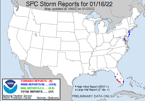
As strong low pressure moved west of our region, it began to occlude. Towards the middle of the night of January 16, a developing occluded front moved through our region. Strong forcing was present along this front, along with extremely strong wind fields. A small amount of mainly non-surface based instability was also present along and just ahead of this front. This combination allowed for some convective elements to develop and to move over eastern portions of the region. This convection caused an enhancement of downward momentum transport, allowing a portion of the extremely strong winds aloft to be transported to the surface. This mainly occurred near and along the New Jersey coast and over the adjacent coastal waters. Numerous wind gusts of 50 to 65 mph were observed, which produced some localized damage. Some radar analysis is presented below.
 |
 |
| Figure 1: KDIX radar reflectivity and base velocity (v) in 30 minute intervals from 0500z 17 Jan 2022 to 0900z 17 Jan 2022. Convection can be seen moving through the region. Very high velocity values, of 70 kt or greater, are present at less than 1000 feet elevation along and ahead of the convective elements. | Figure 2: KDIX radar reflectivity factor (top left), base velocity (v, top right), storm relative motion (SRM, bottom left) and correlation coefficient (CC, bottom right) valid for the 0654 UTC scan time 17 Jan 2022. An area of convection is seen. This storm produced several wind gusts of 55 to 65 mph. The SRM data also shows that it possessed some broad rotation. Finally, the reduced and speckled values of CC coinciding with the high reflectivity (over 60 dBz) are likely indicative of small hail mixed in with rain. At least one report of hail was received. |
 |
 |
| Figure 3: The most notable wind damage of the event occurred near the border of Tuckerton and Little Egg Harbor Twp, NJ. Here, in an aerial photo, dozens of sizable trees are seen uprooted near the Freedom Fields County Park in Tuckerton. Image credit: Joe Martucci and Press of Atlantic City. | Figure 4: Same as Figure 2 valid for the 0624 UTC scan time 17 Jan 2022. This is believed to be the time that the damage in Figure 3 occurred. The reduced CC values (with a minimum around 0.89) are possibly indicative of a tornado debris signature (TDS). However, the aerial photography in Figure 3 is strongly indicative of straight line wind damage. There are a couple of possibilities here. One of that it is simply a radar artifact, though its precise colocation with the Tuckerton damage and apparent multi-scan continuity argues against this. Another possibility is that some of the debris produced as the trees in Figure 3 were toppled (such as by a descending rear inflow jet) was lofted into the strong low level jet, giving the appearance of a TDS. It is also possible that a brief tornado actually occurred. However, in deference to the clear unidirectional nature of the tree damage, and a lack of any photo or video evidence otherwise, there is currently insufficient evidence to confirm a tornado by normal storm survey practices. |
 |
 |
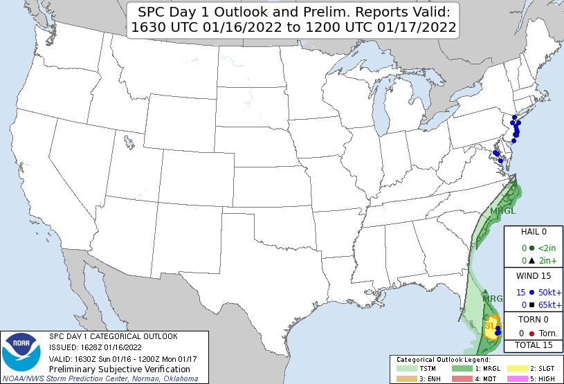 |
| Figure 5: National Preliminary Storm Reports 12z 16 Jan 2022 to 12z 17 Jan 2022 | Figure 6: Zoomed Preliminary Reports for the same period. | Figure 7: Prelim Reports vs. 1630z SPC Convective Outlook |
Coastal flooding was another concern during the January 16-17 storm. A full moon occurred on January 17. Astronomical tides associated with this full moon were not particularly high, but still contributed to an increased risk of coastal flooding during the event. As mentioned in the Overview, a strong easterly low level jet developed ahead of this storm, with a very strong pressure gradient in place. This was also a large storm with a broad wind field. These factors contributed to an unusually large storm surge being produced as this storm impacted our region. A water level rise of 3.5 to 4.5 feet above astronomical values occurred as the storm moved through. The magnitude of this surge was well-forecast by model guidance, such as the ETSS and ESTOFS surge models. The main forecast challenge was timing this surge relative to the times of high and low tides. Had a surge of this magnitude coincided with the time of high tide on the morning of the 17th, major and in some cases near record-breaking coastal flooding would have occurred. This created an unusually challenging and high stakes water level forecast. Fortunately, model guidance correctly identified that the surge would hit most areas closer to low tide on the night of the 16th, while it would occur slightly later and a little closer to the morning high tide in northern New Jersey. This contributed to a Coastal Flood Warning being issued for coastal northern New Jersey, while Coastal Flood Advisories were issued in most other coastal locations. Ultimately, widespread minor coastal flooding occurred, with locally moderate flooding in northern New Jersey. This flooding could have been much worse with only a small shift in surge timing, and it is safe to say the region was largely spared during this event. Some hydrographs are presented below, including a couple which annotate some notable aspects of the event.
The first two images here are annotated. These annotated hydrographs show water levels at the Atlantic City (Figure 1) and Sandy Hook (Figure 2) tidal gauges during the event. In the graph, the blue line “Predictions” simply marks the expected astronomical tide, all other factors aside. The “Predictions” label is somewhat misleading; it is not a forecast made by NWS, it is simply the expected astronomical tide. The red line (labeled as “Preliminary”) shows the actual water levels which occurred. The purple line represents the difference between the green and blue lines. It can be thought of as the storm surge. Positive values represent times when the actual water levels were higher than the astronomical tide. In this case all the values are positive since water levels were elevated. (Note: there is no data for the green line marked “Verified” since the Preliminary values are yet to be formally confirmed and users may disregard this.) These images help to show why coastal flooding in this event was not nearly as severe as it could have been, due to an approximately 4 foot storm surge hitting close to the time of low tide. The remainder of the images are standard hydrographs.
 |
 |
| Figure 1: Annotated hydrograph of water levels at the Atlantic City, NJ tidal gauge during the January 16-17 event. | Figure 2: Same as Fig. 1, for Sandy Hook, NJ. |
 |
 |
 |
| Figure 3: Hydrograph of water levels for Arthur Kill at Perth Amboy (PABN4) during the January 16-17 event. A highly pronounced double peak in water levels is noted, related to the offset between the arrival of peak surge values and the time of high tide. | Figure 4: Same as Fig. 3, for the New Jersey Atlantic coast at Sandy Hook (SDHN4). | Figure 5: Same as Fig. 3, for Barnegat Bay at Barnegat Light (BGLN4). |
 |
 |
 |
| Figure 6: Same as Fig. 3, for Barnegat Bay at Mantoloking (MTLN4). Back bay flooding tended to be worse than oceanfront flooding during this event, with moderate flooding observed at Mantoloking. | Figure 7: Same as Fig. 3, for the New Jersey Atlantic coast at Atlantic City (ACYN4). Again, a pronounced double peak is seen, but here, the surge was so far offset from the high tide that not even minor flooding occurred. | Figure 8: Same as Fig. 3, for Great Egg Harbor Bay at Ocean City (ONCN4). |
 |
 |
| Figure 9: Same as Fig. 3, for the tidal Delaware River at Burlington, NJ (BDRN4). Some minor flooding occurred on the tidal Delaware. | Figure 10: Same as Fig. 3, for Chesapeake Bay at Tolchester Beach (TCBM2). Chesapeake Bay also experienced flooding in this event, which locally approached moderate levels. |


 Coastal Flood
 Marine Forecasts
 Text Products
 Climate Information
 Skywarn
 Submit Storm Report
 Weather Event Archives
 Forecast Discussion
 Emergency Managers
 Briefing Page