Preliminary Local Storm Reports
NWUS51 KPHI 031755
LSRPHI
PRELIMINARY LOCAL STORM REPORT...SUMMARY
NATIONAL WEATHER SERVICE MOUNT HOLLY NJ
155 PM EDT TUE AUG 3 2021
..TIME... ...EVENT... ...CITY LOCATION... ...LAT.LON...
..DATE... ....MAG.... ..COUNTY LOCATION..ST.. ...SOURCE....
..REMARKS..
0248 PM TSTM WND DMG 4 SE HARBESON 38.68N 75.22W
07/29/2021 SUSSEX DE NWS STORM SURVEY
A SUPERCELL THUNDERSTORM IMPACTED THE
EASTERN PORTIONS OF SUSSEX COUNTY, DE IN THE
EARLY AFTERNOON HOURS OF JULY 29. THE
NATIONAL WEATHER SERVICE INVESTIGATED
REPORTS OF DAMAGE IN THIS AREA. A SURVEY WAS
CONDUCTED ALONG A PATH OF RADAR-INDICATED
ROTATION FROM THE NORTH SIDE OF INDIAN RIVER
BAY NEAR LONG NECK AND ANGOLA TO THE AREA OF
OCEAN VIEW, NORTH OF BETHANY BEACH, ON THE
EASTERN SIDE OF THE BAY. MINOR TREE DAMAGE
WAS FOUND IN THE AREA OF HOLLYMOUNT RD, WITH
SMALL TO MEDIUM SIZED TREE LIMBS DOWNED. A
COUPLE OF SAND DUNES WERE OBSERVED AS HAVING
SAND DISPLACED FROM WEST TO EAST NEAR INDIAN
RIVER. NO VISIBLE DAMAGE WAS FOUND IN THE
NARROW STRETCH OF LAND ON THE EAST SIDE OF
THE BAY. VIDEO EVIDENCE EXISTS OF A
WATERSPOUT PRODUCED BY THIS THUNDERSTORM
OVER THE OPEN ATLANTIC. HOWEVER, THERE IS NO
INDICATION THE WATERSPOUT TOUCHED DOWN OVER
INDIAN RIVER BAY OR AT ANY POINT BEFORE
MOVING OVER OPEN WATER. THEREFORE, COMBINED
WITH THE MINOR AND INCONCLUSIVE TREE DAMAGE,
THIS IS CLASSIFIED AS A STRAIGHT LINE WIND
EVENT WITH WINDS OF AROUND 60 MPH.
0259 PM HAIL 3 NW LONG NECK 38.66N 75.19W
07/29/2021 E1.00 INCH SUSSEX DE PUBLIC
ONE INCH HAIL REPORTED NORTH OF LONG NECK,
DE.
0319 PM MARINE TSTM WIND DEWEY BEACH 38.69N 75.07W
07/29/2021 M39 MPH SUSSEX DE MESONET
0319 PM MARINE TSTM WIND INDIAN BEACH 38.68N 75.08W
07/29/2021 M45 MPH ANZ455 DE MESONET
DEWEY BEACH WEATHERFLOW SITE.
0320 PM FUNNEL CLOUD 4 N BETHANY BEACH 38.60N 75.06W
07/29/2021 SUSSEX DE PUBLIC
0334 PM MARINE TSTM WIND 5 E LONG NECK 38.61N 75.06W
07/29/2021 M43 MPH SUSSEX DE DEPT OF HIGHWAYS
DEDOT GAUGE MEASURED GUST.
0346 PM WATER SPOUT 5 N BETHANY BEACH 38.61N 75.06W
07/29/2021 ANZ455 DE TRAINED SPOTTER
PICTURES AND A VIDEO OF A WATERSPOUT IN
PROGRESS JUST OFFSHORE OF THE INDIAN RIVER
INLET.
0350 PM TSTM WND DMG 2 E ALBANY TWP 40.63N 75.85W
07/29/2021 BERKS PA PUBLIC
SEVERAL TREES DOWN IN KEMPTON. TIME
ESTIMATED FROM RADAR.
0404 PM TORNADO 4 N GREENWICH TWP 40.61N 75.81W
07/29/2021 BERKS PA NWS STORM SURVEY
A TORNADO TOUCHED DOWN NEAR TURKEY RD IN
KEMPTON, ALBANY TWP, BERKS COUNTY, PA, JUST
WEST OF THE BORDER WITH LEHIGH COUNTY. ABOUT
15 TREES WERE UPROOTED IN THE AREA OF TURKEY
RD WITH A CONVERGENT DAMAGE PATTERN NOTED IN
MULTIPLE NEARBY CORN FIELDS. THE PATH
CONTINUED TO BETWEEN KUNKELS MILL RD AND RED
RD NEAR THE FAR SOUTHERN TIP OF LYNN TWP IN
LEHIGH COUNTY. MOSTLY MINOR CROP AND TREE
DAMAGE WAS OBSERVED IN THIS AREA, BUT WITH A
CONTINUED CLEAR CONVERGENT PATTERN. A
RESIDENT ON RED RD FILMED THE TORNADO AS IT
PASSED TO HIS SOUTH. THE TORNADO PASSED
THROUGH AN OPEN FIELD BEFORE CROSSING RHOADS
RD, WHERE TREE AND MINOR ROOFING DAMAGE WERE
SUSTAINED. EAST OF RHOADS RD, A NUMBER OF
TREES WERE SNAPPED AND UPROOTED AS THE
TORNADO APPROACHED NEW SMITHVILLE RD. THE
TORNADO CROSSED GOLDEN KEY RD, UPROOTING A
FEW MORE TREES, BEFORE DISSIPATING IN A
FIELD PRIOR TO REACHING LOCH VALLEY RD IN
WEISENBERG TWP. THE EXTENT OF TREE DAMAGE
BOTH NEAR THE START OF THE PATH IN KEMPTON
AND IN THE NEW SMITHVILLE RD AREA MERITED AN
EF1 RATING.
0405 PM TSTM WND DMG NEW TRIPOLI 40.68N 75.75W
07/29/2021 LEHIGH PA NEWSPAPER
DOWNED TREES AND POWER LINES IN THE NEW
TRIPOLI AREA. SOME STRUCTURAL DAMAGE TO AN
OUTSIDE BARN AS WELL WITH PIECES OF ROOFING
OFF. TIME ESTIMATED FROM RADAR.
0405 PM TSTM WND DMG 1 NW WEISENBERG TWP 40.62N 75.74W
07/29/2021 LEHIGH PA DEPT OF HIGHWAYS
UTILITY POLES DOWN.
0408 PM TSTM WND DMG LYNN TWP 40.68N 75.81W
07/29/2021 LEHIGH PA PUBLIC
TREES AND WIRES DOWN. TIME ESTIMATED BY
RADAR.
0414 PM TSTM WND DMG 1 ESE WEISENBERG TWP 40.60N 75.72W
07/29/2021 LEHIGH PA PUBLIC
TREES AND WIRES DOWN ON 863. ROUTE 863 IS
CLOSED DUE TO DEBRIS.
0415 PM TSTM WND DMG 1 NW WEISENBERG TWP 40.62N 75.76W
07/29/2021 LEHIGH PA 911 CALL CENTER
TREES AND WIRES DOWN WITH PARTIALLY TORN OFF
ROOF OF A BUILDING. POSSIBLE TORNADO DAMAGE.
TIME ESTIMATED BY RADAR.
0427 PM TSTM WND DMG SLATINGTON 40.75N 75.60W
07/29/2021 LEHIGH PA 911 CALL CENTER
TREE DOWN AND UPROOTED. TIME ESTIMATED BY
RADAR.
0428 PM TSTM WND DMG 1 NNW SLATINGTON 40.76N 75.61W
07/29/2021 LEHIGH PA NEWSPAPER
CORRECTS PREVIOUS TSTM WND DMG REPORT FROM 1
NNW SLATINGTON TO 428 PM. DOWNED TREE ON
POWER LINES ON SHADOW OAKS LANE. POSSIBLE
TORNADO.
0428 PM TSTM WND DMG 1 NW WALNUTPORT 40.76N 75.60W
07/29/2021 LEHIGH PA NEWSPAPER
PLANES DAMAGED AT SLATINGTON AIRPORT.
0428 PM TSTM WND DMG 1 NNW SLATINGTON 40.76N 75.61W
07/29/2021 LEHIGH PA PUBLIC
NUMEROUS TREES AND WIRES DOWN AT AND AROUND
NORTHERN LEHIGH HIGH SCHOOL AND ON CENTER
STREET IN SLATINGTON. POSSIBLE TORNADO.
0431 PM TSTM WND DMG 1 NNW WALNUTPORT 40.77N 75.60W
07/29/2021 NORTHAMPTON PA EMERGENCY MNGR
MULTIPLE DOWNED >3 INCH TREE LIMBS. POSSIBLE
TORNADO. TIME ESTIMATED FROM RADAR.
0431 PM TSTM WND DMG 1 NW BERLINSVILLE 40.78N 75.59W
07/29/2021 NORTHAMPTON PA EMERGENCY MNGR
MULTIPLE TREES DOWN ON TIMBERLINE RD.
POSSIBLE TORNADO. TIME ESTIMATED FROM RADAR.
0431 PM TSTM WND DMG 1 WNW BERLINSVILLE 40.78N 75.59W
07/29/2021 NORTHAMPTON PA EMERGENCY MNGR
MULTIPLE TREES DOWN ON LEHIGH DR. POSSIBLE
TORNADO. TIMES ESTIMATED FROM RADAR.
0440 PM TSTM WND GST WEST CATASAUQUA 40.64N 75.49W
07/29/2021 M42 MPH LEHIGH PA PUBLIC
MEASURED 42 MPH WIND GUST AND PEA-SIZED HAIL
IN WHITEHALL TOWNSHIP, PA.
0443 PM FLASH FLOOD PALMERTON 40.80N 75.62W
07/29/2021 CARBON PA PUBLIC
ROADS FLOODED IN PALMERTON, PA.
0457 PM TSTM WND DMG 2 SSW HELLERTOWN 40.55N 75.35W
07/29/2021 NORTHAMPTON PA NEWSPAPER
DOWNED TREES AND POWER LINES ON HAFLER ROAD
OFF APPLES CHURCH ROAD IN LOWER SAUCON
TOWNSHIP. TIME ESTIMATED FROM RADAR.
POSSIBLE TORNADO.
0458 PM FUNNEL CLOUD 2 WSW HELLERTOWN 40.57N 75.37W
07/29/2021 NORTHAMPTON PA PUBLIC
PHOTOGRAPH OF A FUNNEL CLOUD ON TWITTER JUST
NORTH OF CENTER VALLEY, PA.
0458 PM TSTM WND DMG 2 S HELLERTOWN 40.55N 75.34W
07/29/2021 NORTHAMPTON PA EMERGENCY MNGR
3 TO 4 BUILDINGS DAMAGED AT THE INTERSECTION
OF LEITHSVILLE RD AND WEAVERS LN. ALSO SOME
TREE DAMAGE IN THE AREA. POSSIBLE TORNADO.
TIME ESTIMATED FROM RADAR.
0500 PM TSTM WND DMG 2 S HELLERTOWN 40.55N 75.34W
07/29/2021 NORTHAMPTON PA BROADCAST MEDIA
THREE BUILDINGS DAMAGED NEAR THE
INTERSECTION OF LEITHSVILLE ROAD AND WEAVERS
LANE.
0511 PM FLOOD 1 N EASTON 40.71N 75.21W
07/29/2021 NORTHAMPTON PA PUBLIC
SOCIAL MEDIA VIDEO OF MINOR STREET FLOODING
ON CATTELL ST. AND W MONROE ST.
0511 PM TSTM WND DMG QUAKERTOWN 40.44N 75.34W
07/29/2021 BUCKS PA PUBLIC
SEVERAL TREES DOWN, ALSO HAVE REPORTS FROM
BUCKINGHAM AND UPPER MAKEFIELD. TIME
ESTIMATED FROM RADAR.
0515 PM TSTM WND GST 1 E MILFORD SQUARE 40.44N 75.38W
07/29/2021 M53 MPH BUCKS PA MESONET
QUAKERTOWN.
0515 PM TSTM WND GST 1 ESE MILFORD SQUARE 40.44N 75.38W
07/29/2021 M53 MPH BUCKS PA AWOS
QUAKERTOWN AIRPORT AWOS MEASURED GUST.
0530 PM TSTM WND DMG OTTSVILLE 40.48N 75.17W
07/29/2021 BUCKS PA DEPT OF HIGHWAYS
DEBRIS BLOCKING FRETZ VALLEY ROAD, GEIGEL
HILL ROAD AND CREAMERY ROAD.
0540 PM TORNADO 1 N GARDENVILLE 40.39N 75.11W
07/29/2021 BUCKS PA NWS STORM SURVEY
TREE DAMAGE BEGAN IN THE AREA OF BRADSHAW RD
IN PLUMSTEAD TWP IN BUCKS COUNTY, WHERE A
FEW SIZABLE LIMBS WERE DOWNED AND A COUPLE
OF LARGER BUT WEAKENED TREES WERE SNAPPED.
THE TORNADO THEN ENTERED A CORNFIELD NEAR
THE INTERSECTION OF FERRY RD AND POINT
PLEASANT PIKE. SOME DEGREE OF CONVERGENCE
WAS NOTED IN A NARROW PATH OF DOWNED CORN,
THOUGH IT WAS NOT OVERLY STRONG. IN
ADDITION, SOME TREES ADJACENT TO AND
SOUTHEAST OF THE CORNFIELD WERE ALSO
DAMAGED. THE DAMAGE BECAME MORE SUBSTANTIAL
WITH A CLEARER ROTATION SIGNATURE OBSERVED
IN THE AREA OF RIDGEVIEW DR, WHERE A NUMBER
OF TREES WERE SNAPPED, FAVORING HIGHER
ELEVATION AREAS ALONG A RIDGE LINE. THE
SNAPPING AND SHEARING OF TREES IN THAT AREA
AND THE NATURE OF THE DEBRIS FIELD STRONGLY
INDICATED TORNADIC DAMAGE, WITH THE
MAGNITUDE OF DAMAGE MERITING AN EF1 RATING.
THE TORNADO CONTINUED SOUTHEASTWARD THROUGH
CARVERSVILLE RD AND TO THE AREA OF LONG LN
IN BUCKINGHAM TWP. SEVERAL RESIDENCES ALONG
AND NEAR LONG LN SUSTAINED TREE DAMAGE. THE
TORNADO IMPACTED MAXIMUCK`S FARM MARKET ON
LONG LN, WHERE GREENHOUSES SUSTAINED ROOF
DAMAGE AND SOME UPLIFT OF THEIR FRAMES. SOME
CONVERGENCE WAS ALSO NOTED IN CROP FIELDS ON
THE PROPERTY. JUST SOUTHEAST OF THE
GREENHOUSES, A BARN ON THE PROPERTY WAS
HEAVILY DAMAGED WITH A PARTIAL COLLAPSE OF
ITS WALLS. HOWEVER, JUST BEYOND THE BARN, A
LARGE STRETCH OF CORNFIELDS AND A TREE LINE
BEYOND THE CORNFIELDS WERE LEFT UNTOUCHED,
INDICATING THE TORNADO LIFTED NEAR THE
DAMAGED BARN. THE NATIONAL WEATHER SERVICE
WOULD LIKE TO THANK THE BUCKS COUNTY
EMERGENCY MANAGEMENT AGENCY AND THE
PENNSYLVANIA EMERGENCY MANAGEMENT AGENCY FOR
THEIR ASSISTANCE IN COMPLETING THIS SURVEY.
0550 PM TSTM WND DMG LAHASKA 40.35N 75.04W
07/29/2021 BUCKS PA BROADCAST MEDIA
WIDESPREAD TREE DAMAGE ALONG WITH SOME
DAMAGE TO STRUCTURES IN BUCKINGHAM TOWNSHIP.
0552 PM MARINE TSTM WIND 2 E LANOKA HARBOR 39.86N 74.13W
07/29/2021 M39 MPH OCEAN NJ MESONET
KITE ISLAND.
0557 PM TSTM WND DMG NEW HOPE 40.37N 74.95W
07/29/2021 BUCKS PA TRAINED SPOTTER
NUMEROUS REPORTS OF TREES AND LINES DOWN IN
NEW HOPE. POSSIBLE TORNADO. TIME ESTIMATED
FROM RADAR.
0559 PM TORNADO 1 S NEW HOPE 40.34N 74.95W
07/29/2021 BUCKS PA NWS STORM SURVEY
THE SUPERCELL STORM WHICH PRODUCED A TORNADO
IN PLUMSTEAD TWP CYCLED AND PRODUCED ANOTHER
TORNADO BEGINNING IN NEW HOPE IN BUCKS
COUNTY, PENNSYLVANIA. TREE DAMAGE BEGAN NEAR
RIVER RD JUST WEST OF THE DELAWARE RIVER,
WITH A PORTION OF RIVER RD CLOSED AND
IMPASSABLE DUE TO DOWNED TREES. THE TORNADO
CROSSED THE DELAWARE RIVER AND ENTERED
MERCER COUNTY, NEW JERSEY, IN THE AREA OF
WASHINGTON CROSSING. MULTIPLE REPORTS OF
RESIDENTIAL TREE DAMAGE WERE RECEIVED FROM
WASHINGTON CROSSING, AND THE SURVEY TEAM
OBSERVED TREE DAMAGE ALONG RIVER RD ON THE
NEW JERSEY SIDE OF THE DELAWARE RIVER. FROM
THERE THE TORNADO CONTINUED SOUTHEAST AND
CROSSED PLEASANT VALLEY RD. THE FIRST
INDICATIONS OF EF2 DAMAGE CAME ON THAT ROAD,
WITH NUMEROUS LARGE HARDWOOD AND SOFTWOOD
TREES SNAPPED, SHEARED, AND/OR UPROOTED. THE
TORNADO CONTINUED SOUTHEASTWARD AND CROSSED
THROUGH BALDPATE MOUNTAIN. CONTINUED HEAVY
TREE DAMAGE WAS OBSERVED IN THIS AREA. AN
ACCESS ROAD TO THE TOP OF THE MOUNTAIN WAS
BARELY PASSABLE WHEN THE SURVEY TEAM REACHED
IT IN LATE AFTERNOON, AFTER MANY HOURS OF
TREE CLEARING WORK BY LOCAL PARKS OFFICIALS
AND PRIVATE COMPANIES. HUNDREDS OF TREES
WERE SNAPPED OR DAMAGED ON THIS MOUNTAIN.
DAMAGE CONTINUED DOWN THE MOUNTAIN THROUGH
FIDDLERS CREEK RD AND CHURCH RD. THE TORNADO
PATH THEN CROSSED WASHINGTON CROSSING STATE
PARK. FURTHER DAMAGE WAS OBSERVED JUST
SOUTHEAST ALONG BEAR TAVERN RD. IN FACT,
SOME OF THE LARGEST DOWNED TREES WERE
OBSERVED IN THIS AREA. HOWEVER, BY THIS
POINT DAMAGE BECAME INCREASINGLY
UNIDIRECTIONAL AS THE STORM`S REAR FLANK
DOWNDRAFT LIKELY WRAPPED AROUND THE TORNADIC
CIRCULATION. SUFFICIENT EVIDENCE OF TORNADIC
WINDS STILL EXISTED IN THE BEAR TAVERN RD
AREA, BUT IT IS ESTIMATED THE TORNADO LIFTED
SOON AFTER, SHORTLY BEFORE ENTERING MUCH
MORE DENSELY POPULATED AREAS NEAR THE
TRENTON MERCER AIRPORT. THE NATIONAL WEATHER
SERVICE WOULD LIKE TO THANK THE MERCER
COUNTY OFFICE OF EMERGENCY MANAGEMENT FOR
THEIR ASSISTANCE IN COMPLETING THE SURVEY.
0602 PM TSTM WND DMG 2 SSE BEDMINSTER TWP 40.65N 74.64W
07/29/2021 SOMERSET NJ PUBLIC
FEW SMALL TREES BLOWN DOWN ON TIMOTHY LANE
IN BEDMINSTER. TIME ESTIMATED FROM RADAR.
0610 PM HAIL 3 NW PENNINGTON 40.36N 74.83W
07/29/2021 E0.75 INCH MERCER NJ PUBLIC
PUBLIC REPORTS MARBLE SIZE HAIL. TIME
ESTIMATED FROM RADAR.
0610 PM TSTM WND DMG WASHINGTON CROSSING 40.29N 74.87W
07/29/2021 BUCKS PA DEPT OF HIGHWAYS
DEBRIS BLOCKING PA ROUTE 32.
0610 PM TSTM WND DMG 1 NW WASHINGTON CROSSIN 40.31N 74.88W
07/29/2021 MERCER NJ PUBLIC
MULTIPLE TREES DOWN IN TITUSVILLE, NJ.
POSSIBLE TORNADO. TIME ESTIMATED FROM RADAR.
0610 PM TSTM WND DMG WASHINGTON CROSSING 40.30N 74.87W
07/29/2021 MERCER NJ DEPT OF HIGHWAYS
TREES DOWN ON NJ ROUTE 29 WITH THE HIGHWAY
CLOSED.
0611 PM TSTM WND DMG 3 NNW WASHINGTON CROSSI 40.34N 74.89W
07/29/2021 MERCER NJ TRAINED SPOTTER
TREES AND WIRES DOWN ON PLEASANT VALLEY ROAD
IN HOPEWELL.
0619 PM TSTM WND DMG 1 S PENNINGTON 40.32N 74.79W
07/29/2021 MERCER NJ PUBLIC
MULTIPLE TREES SNAPPED AND UPROOTED NEAR
PENNINGTON, NJ. POSSIBLE TORNADO. TIME
ESTIMATED FROM RADAR.
0621 PM TSTM WND GST TRENTON MERCER AIRPORT 40.28N 74.81W
07/29/2021 M46 MPH MERCER NJ ASOS
0625 PM TSTM WND DMG LAWRENCE TWP 40.28N 74.74W
07/29/2021 MERCER NJ FIRE DEPT/RESCUE
WIRES DOWN ALONG WEST CHURCH ROAD.
0627 PM TORNADO 1 NNW SLATINGTON 40.77N 75.62W
07/29/2021 LEHIGH PA NWS STORM SURVEY
A TORNADO TOUCHED DOWN ON THE GROUNDS OF
NORTHERN LEHIGH HIGH SCHOOL IN SLATINGTON.
SEVERAL TREES WERE SNAPPED OR UPROOTED AT
THE HIGH SCHOOL, WITH MOST OF THE SNAPPING
OCCURRING HIGH UP IN THE TREES. A WOODEN
DUGOUT ON THE SCHOOL`S BASEBALL FIELD LOST
ITS ROOF, AND SOME UNANCHORED METAL
BLEACHERS WERE TOSSED. DAMAGE WAS MOSTLY
BLOWN IN A SIMILAR WEST TO EAST DIRECTION,
BUT THERE WAS SOME EVIDENCE OF CONVERGENCE
ESPECIALLY IN TREE DAMAGE IN THE AREA. THE
PATH CONTINUED ALMOST STRAIGHT WEST TO EAST
FROM THE HIGH SCHOOL TO THE SLATINGTON
AIRPORT. AN AIRPLANE HANGAR DOOR WAS BLOWN
OUT, AND THERE WAS TREE DAMAGE ON THE
AIRPORT PROPERTY. DAMAGE BECAME MORE
UNIDIRECTIONAL NEAR THE AIRPORT AS THE
CIRCULATION LIKELY GUSTED OUT. LITTLE IF ANY
DAMAGE OCCURRED EAST OF THE AIRPORT
PROPERTY, AND THAT IS WHERE THE TORNADO PATH
IS ESTIMATED TO HAVE ENDED. THE NATIONAL
WEATHER SERVICE WOULD LIKE TO THANK MR. LOU
RUH FOR HIS ASSISTANCE IN COMPLETING THIS
SURVEY.
0648 PM TSTM WND DMG 1 SE ROBBINSVILLE TWP. 40.22N 74.63W
07/29/2021 MERCER NJ PUBLIC
LOTS OF TREE BRANCHES DOWN AND POWER IS OUT
IN ROBBINSVILLE NORTH OF 130. TIME ESTIMATED
FROM RADAR.
0648 PM FLASH FLOOD 2 NW LUMBERVILLE 40.42N 75.06W
07/29/2021 BUCKS PA PUBLIC
SOCIAL MEDIA VIDEO OF WATER RUSHING ACROSS
RIVER ROAD. MULTIPLE ROADS FLOODED.
0649 PM FUNNEL CLOUD WILLOW GROVE 40.15N 75.12W
07/29/2021 MONTGOMERY PA PUBLIC
ROTATING WALL CLOUD OBSERVED NEAR WILLOW
GROVE, PA. TIME ESTIMATED FROM RADAR.
0656 PM TORNADO WINDSOR 40.24N 74.58W
07/29/2021 MERCER NJ NWS STORM SURVEY
THE WINDSOR-ROBBINSVILLE TOWNSHIP TORNADO
BEGAN ON ROUTE 130 JUST SOUTH OF THE TOWN OF
WINDSOR NEAR THE ASSUNPINK CREEK. A FEW
HARDWOOD TREES WERE UPROOTED ALONG THE
HIGHWAY NEAR THE CHESTNUT MONTESSORI. THE
BUILDING LOST A PORTION OF ITS ROOFING
MATERIAL AND SEVERAL OTHER HARDWOOD TREES
WERE UPROOTED OR SNAPPED JUST BEHIND THE
PROPERTY INTO A SMALL WOODED AREA. THE
TORNADO THEN CONTINUED IN A SOMEWHAT
TRANSIENT AND WEAK MANNER THROUGH A SERIES
OF FIELDS AND TREE LINES. A FEW LARGE TREE
BRANCHES WERE SNAPPED OFF NEAR A FARM HOME
ON WINDSOR ROAD AND A HARDWOOD TREE IN A
TREE LINE WAS UPROOTED ACROSS THE STREET.
THE SPORADIC TREE DAMAGE CONTINUED ALONG
PERRINEVILLE ROAD WHERE A LARGE SECTION OF A
TREE WAS SNAPPED OFF AT ANOTHER RESIDENCE.
THE TORNADO THEN PRODUCED AN AREA OF INTENSE
CONVERGENT TREE DAMAGE NEAR THE INTERSECTION
OF PERRINEVILLE ROAD AND VOELBEL ROAD WHERE
NUMEROUS TREES WERE SNAPPED OR UPROOTED. THE
TORNADO ENDED JUST DOWNSTREAM FROM THIS
INTERSECTION AT A RESIDENCE ON PERRINEVILLE
ROAD WHERE A FINAL TREE WAS UPROOTED. THE
NATIONAL WEATHER SERVICE WOULD LIKE TO THANK
THE MERCER COUNTY OFFICE OF EMERGENCY
MANAGEMENT FOR THEIR ASSISTANCE IN PROVIDING
INFORMATION FOR THIS SURVEY.
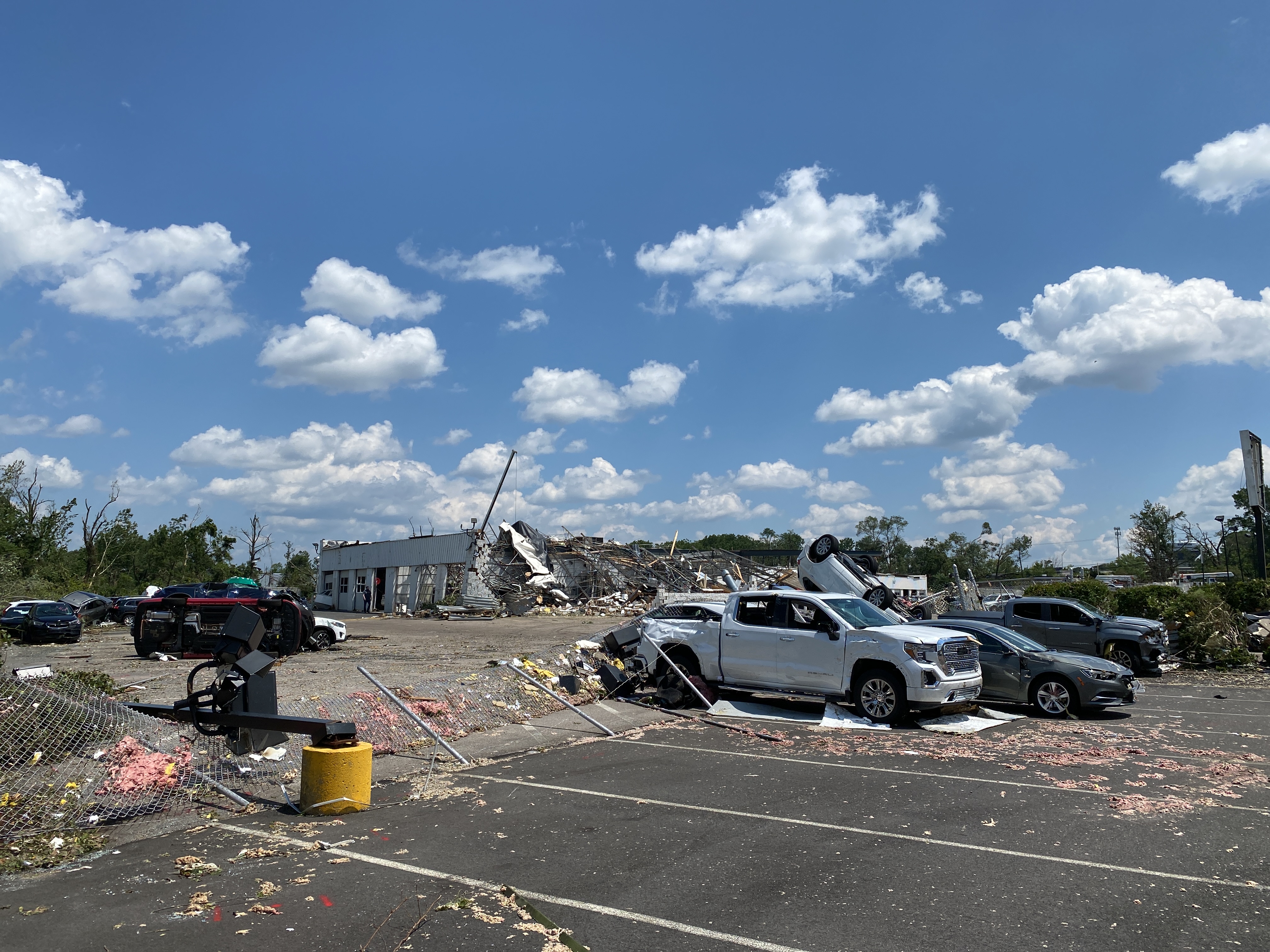
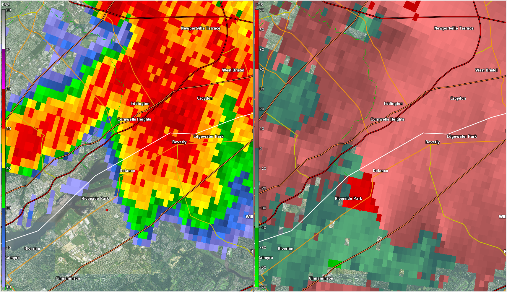
0704 PM TORNADO SOMERTON 40.13N 75.00W
07/29/2021 PHILADELPHIA PA NWS STORM SURVEY
*** 5 INJ ***
THE SOMERTON-TREVOSE-BENSALEM TORNADO BEGAN
IN SOMERTON IN PHILADELPHIA COUNTY NEAR
SOUTHAMPTON ROAD, KELVIN AVENUE, AND TREVOSE
ROAD WHERE IT UPROOTED AND BLEW DOWN LARGE
LIMBS FROM A FEW SOFTWOOD AND HARDWOOD
TREES. THE TORNADO CROSSED COUNTY LINE ROAD
INTO TREVOSE IN BUCKS COUNTY WHERE A LARGE
TREE WAS UPROOTED. THE TORNADO CONTINUED
BETWEEN TREVOSE ROAD AND PEYTON STREET WHERE
ADDITIONAL TREE DAMAGE OCCURRED BEFORE
CROSSING LUKENS STREET. THE TORNADO THEN
VERY BRIEFLY CROSSED BACK INTO PHILADELPHIA
COUNTY AT THE NORTHERN TIP OF POQUESSING
VALLEY PARK WHERE A FEW TREES WERE UPROOTED.
THE TORNADO THEN CROSSED BACK INTO TREVOSE
IN BUCKS COUNTY WHERE IT CAUSED SOME MINOR
COSMETIC DAMAGE TO SOME HOMES IN THE
BEECHWOOD ESTATES NEIGHBORHOOD AND BLEW DOWN
SEVERAL SECTIONS OF VINYL FENCING. SEVERAL
SMALL TREES WERE ALSO SNAPPED OR UPROOTED IN
AND JUST SOUTH AND EAST OF THE RESIDENTIAL
NEIGHBORHOOD. AS THE TORNADO APPROACHED
SOMERTON ROAD, IT BEGAN INTENSIFYING AND
WIDENING SUBSTANTIALLY AS IT MOVED INTO THE
METROPOLITAN INDUSTRIAL CENTER. NUMEROUS
SOFTWOOD AND HARDWOOD TREES WERE SNAPPED OR
UPROOTED IN THE SUEZ WATER COMPANY PROPERTY
SOUTHWEST OF AND ALONG SOMERTON ROAD. FIVE
WOODEN POWER POLES WERE SNAPPED NEAR THE
GROUND ALONG SOMERTON ROAD AS WELL AT THE
NORTHERN END OF THE SUEZ PROPERTY. ALL SEVEN
WAREHOUSE BUILDINGS IN THE INDUSTRIAL
COMPLEX NORTHEAST OF SOMERTON ROAD SUSTAINED
AT LEAST MINOR DAMAGE, WITH THE MOST
SIGNIFICANT OCCURRING TO THE NORTHTEC
BUILDING. NUMEROUS ROOF MOUNTED HVAC UNITS
WERE SHIFTED OR BLOWN OFF OF A FEW OF THE
BUILDINGS IN THE INDUSTRIAL COMPLEX. OPEN
BAY DOORS IN THE WESTERN- MOST BUILDING
CAUSED A NON-LOAD BEARING INTERIOR WALL TO
COLLAPSE. A SEDAN WAS LIFTED AND FLIPPED
OVER IN THE NORTHTEC PARKING LOT AND A STEEL
FLAG POLE BEARING A FLAG FLATTENED
COMPLETELY TO THE GROUND. THE NORTHTEC
BUILDING SUSTAINED SUBSTANTIAL STRUCTURAL
DAMAGE WHERE LARGE SECTIONS OF ROOFING
MATERIAL WERE REMOVED. ADDITIONALLY,
NUMEROUS EXTERIOR PANELING WAS BLOWN OFF,
GARAGE BAY DOORS WERE BLOWN OUT, A FEW
WINDOWS WERE BLOWN OUT, AND AT LEAST TWO
LARGE HVAC UNITS WERE BLOWN OFF OF THE
BUILDING. NUMEROUS SOFTWOOD AND HARDWOOD
TREES WERE UPROOTED OR SNAPPED IN THE
INDUSTRIAL COMPLEX AND IMMEDIATELY ADJACENT
AREAS. A CELLPHONE TOWER ADJACENT TO THE
INDUSTRIAL COMPLEX HAD ALL OF THE ANTENNAS
BLOWN OFF, BUT THE TOWER ITSELF DID NOT
COLLAPSE. SOUTHEAST OF THE INDUSTRIAL
COMPLEX, MINOR COSMETIC DAMAGE OCCURRED TO
SOME HOMES ALONG CARTER ROAD IN A
RESIDENTIAL NEIGHBORHOOD. TREE DAMAGE
ASSOCIATED WITH THE TORNADO OCCURRED ALONG
CARTER ROAD AND SUSSEX ROAD NORTH OF
BUCKFIELD TERRACE. THIS WAS THE AREA WHERE
THE TORNADO CIRCULATION REACHED ITS WIDEST
EXTENT OF AROUND THREE TENTHS OF A MILE. AS
THE TORNADO NEARED AND CROSSED THE
PENNSYLVANIA TURNPIKE (I- 276), AN OVERHEAD
ROADWAY INFORMATION SIGN WAS BLOWN OFF AND A
PORTION OF IT LANDED DOWNSTREAM NEARLY A
HALF MILE AWAY. JUST NORTH OF THE TURNPIKE,
MINOR COSMETIC DAMAGE OCCURRED TO A HOTEL
BUILDING WHERE A TREE WAS ALSO UPROOTED IN
THE PARKING LOT. A LARGE BILLBOARD WAS BLOWN
OVER JUST NORTH OF THE TURNPIKE AND SOUTH OF
STREET ROAD. A SMALL UTILITY BUILDING NEARBY
HAD ITS ROOF BLOWN OFF. THE NORTHERN- MOST
EXTENT OF THE DAMAGE OCCURRED ON THE TOSCANA
52 RESTAURANT PROPERTY WHERE THE TORNADO
BLEW DOWN SOME CHAIN LINK FENCING AND
UPROOTED A FEW SMALL TREES IN THE PARKING
LOT. THE TORNADO CONTINUED
EAST-NORTHEASTWARD ACROSS STREET ROAD TOWARD
THE FAULKNER CAR DEALERSHIP COMPLEX WHERE IT
BEGAN INTENSIFYING AND SOMEWHAT NARROWING
ITS PATH OF DAMAGE. THE FOUR DEALERSHIP
SHOWROOMS SUSTAINED SIGNIFICANT DAMAGE WHERE
MOST WINDOWS WERE BLOWN OUT AND AT LEAST
SOME ROOFING MATERIAL WAS BLOWN OFF. THE
MOST SIGNIFICANT DAMAGE OCCURRED TO THE
BUICK/GMC SHOWROOM WHERE MOST OF THE ROOFING
MATERIAL WAS BLOWN OFF, ALL WINDOWS AND
DOORS WERE BLOWN OUT, AND EXTERIOR WALLS
EXHIBITED FRACTURING DUE TO STRESS FROM THE
WIND. ROOF HVAC UNITS OF THIS BUILDING WERE
TOSSED INTO THE PARKING LOT BEHIND THE
BUILDING. ALL OF THE DEALERSHIP SIGNS NEAR
THE MAIN ROAD WERE DESTROYED. SCORES OF NEW
AND USED VEHICLES SUSTAINED SIGNIFICANT
DAMAGE FROM FLYING DEBRIS OR FROM BEING
PUSHED OR TOSSED TROUGH THE AIR. THE TORNADO
CONTINUED TOWARD THE DEALERSHIP`S MAIN
SERVICE GARAGE WHERE THE MOST SIGNIFICANT
DAMAGE OCCURRED. THE SOUTHWESTERN PORTION OF
THE BUILDING WAS DESTROYED WITH MOST
EXTERIOR WALLS COLLAPSING COMPLETELY AND ALL
ROOFING MATERIAL BLOWN OFF. INTERIOR WALLS
MOSTLY REMAINED STANDING. ROOF HVAC UNITS
WERE TOSSED OFF OF THE BUILDING WITH ONE
UNIT LANDING NEARLY 200 YARDS DOWNSTREAM OF
THE BUILDING. DAMAGE SUSTAINED TO THE
BUILDING DECREASED SOMEWHAT TOWARD THE
EASTERN END OF IT WHERE PORTIONS OF THE
EXTERIOR WALLS WERE DAMAGED AND ALMOST ALL
GARAGE BAY DOORS WERE BLOWN OUT. THE WIND
RUSHING THROUGH THE GARAGE AREA CARRIED
DEBRIS, CAR PARTS, AND TOOLS WELL AWAY FROM
THE STRUCTURE DOWNSTREAM. SOME VEHICLES NEAR
THE MAIN GARAGE BUILDING WERE COMPLETELY
DESTROYED FROM LARGE PIECES OF FLYING DEBRIS
OR FROM BEING TOSSED AND DROPPED BACK ONTO
THE GROUND. A SMALL PICKUP TRUCK WAS CRUSHED
FROM A COLLAPSED EXTERIOR WALL. FIVE PEOPLE
REPORTEDLY SUSTAINED MINOR INJURIES AT THE
DEALERSHIP COMPLEX. THE TORNADO CONTINUED
EAST-NORTHEAST TOWARD THE WEISSER HOMES
MOBILE HOME PARK AND INTO AN AREA OF TREES
WHICH SUSTAINED SIGNIFICANT DAMAGE. MOST
TREE CANOPIES AND LIMBS WERE COMPLETELY
STRIPPED FROM THE STILL STANDING OR SNAPPED
TRUNKS OF HARDWOOD TREES IN THIS AREA. A
LARGE STORAGE CONTAINER FILLED WITH CAR
PARTS FROM THE SERVICE GARAGE PARKING LOT
UPSTREAM WAS LOFTED INTO THE AIR AND DROPPED
INTO THIS AREA OF TREES. AN UNINHABITED
MOBILE HOME MODEL WAS LIFTED AND COMPLETELY
DESTROYED AT THE MOBILE HOME PARK. ANOTHER
DOUBLE-WIDE MOBILE HOME HAD A LARGE PORTION
OF ITS ROOF BLOWN OFF. SEVERAL OTHER MOBILE
HOME SUSTAINED VARYING DEGREES OF DAMAGE AS
WELL. A LARGE AMOUNT OF VARIOUS DEBRIS FROM
THE DEALERSHIP COMPLEX LANDED IN THIS MOBILE
HOME PARK. NUMEROUS SOFTWOOD AND HARDWOOD
TREES NEAR AND JUST DOWNSTREAM OF THIS AREA
WERE SNAPPED OR UPROOTED ALONG OLD LINCOLN
HIGHWAY. AT THIS STAGE, THE TORNADO DAMAGE
PATH NARROWED CONSIDERABLY AND INTENSITY
WEAKENED SIGNIFICANTLY AS IT CROSSED OLD
LINCOLN HIGHWAY AND MOVED TOWARD THE LOWE`S
AND WALMART SHOPPING CENTERS ON ROUTE 1. THE
TORNADO PASSED OVER THESE SHOPPING CENTERS,
BUT NO STRUCTURAL DAMAGE WAS NOTED TO THESE
STRUCTURES. NUMEROUS SMALL TREES WERE
SNAPPED AND UPROOTED IN THE LARGE PARKING
LOT AREA AND LINE OF TREES JUST NORTH OF THE
BENSALEM TURNPIKE INTERCHANGE. SOME EXIT
RAMP SIGNS WERE BLOWN DOWN IN THE
INTERCHANGE AREA. THE TORNADO DAMAGE BECAME
SOMEWHAT DISCONTINUOUS AS IT CONTINUED
EAST-SOUTHEAST INTO BENSALEM ACROSS ROUTE 1
AND TOWARD A RESIDENTIAL NEIGHBORHOOD.
SEVERAL HOMES IN THE NEIGHBORHOOD SUSTAINED
LOSS OF SOME ROOFING MATERIAL AND OTHER
COSMETIC DAMAGE IN ADDITION TO SOME TREE
DAMAGE. THE TORNADO CONTINUED ACROSS
ROCKHILL ROAD AND ALONG RICHLIEU ROAD TOWARD
THE CHRISTIAN LIFE CENTER WHERE SEVERAL
TREES WERE SNAPPED OR UPROOTED. THE CHURCH`S
STEEPLE HAD SOME PANELING BLOWN OFF, BUT THE
STEEPLE ITSELF WAS NOT DAMAGED OTHERWISE.
THE TORNADO CONTINUED WEAKENING AS IT
CROSSED GALLOWAY ROAD THEN DISSIPATED IN THE
BENSALEM TOWNSHIP COMMUNITY PARK WHERE SOME
MINOR TREE DAMAGE OCCURRED. NO KNOWN SERIOUS
INJURIES OR FATALITIES OCCURRED FROM THIS
TORNADO. THE NATIONAL WEATHER SERVICE SURVEY
TEAM WOULD LIKE TO THANK THE BUCKS COUNTY
EMERGENCY MANAGEMENT AGENCY AND PENNSYLVANIA
EMERGENCY MANAGEMENT AGENCY FOR THEIR
ASSISTANCE WITH THE SURVEY.
0705 PM FUNNEL CLOUD 2 SSW TWIN RIVERS 40.24N 74.51W
07/29/2021 MERCER NJ PUBLIC
PHOTO FROM TWITTER OF A FUNNEL CLOUD
SOUTHEAST OF EAST WINDSOR. PROBABLE TORNADO.
TIME ESTIMATED FROM RADAR.
0705 PM TSTM WND DMG 1 SW NORTHEAST PHILADEL 40.08N 75.03W
07/29/2021 PHILADELPHIA PA EMERGENCY MNGR
WIND DAMAGE REPORTED IN THE VICINITY OF
GRANT AVE AND ROOSEVELT BLVD. BRANCHES DOWN,
ROOF COVERING BLOWN OFF A BUILDING. TIME
ESTIMATED FROM RADAR.
0705 PM TSTM WND DMG 1 E WINDSOR 40.24N 74.56W
07/29/2021 MERCER NJ PUBLIC
NUMEROUS TREES DOWN ON VOELBEL ROAD AND
PERRINEVILLE ROAD. POSSIBLE TORNADO. TIMES
ESTIMATED FROM RADAR.
0707 PM TSTM WND DMG 1 WNW FEASTERVILLE-TREV 40.13N 74.98W
07/29/2021 BUCKS PA PUBLIC
FAULKNER AUTO BUILDING ROOF WAS BLOWN OFF
AND COLLAPSED. MULTIPLE SECTIONS OF THE
EXTERIOR WALLS ALSO APPEAR TO BE COLLAPSED.
PROBABLE TORNADO. TIME ESTIMATED RADAR.
0707 PM TSTM WND DMG FEASTERVILLE-TREVOSE 40.13N 74.97W
07/29/2021 BUCKS PA PUBLIC
REPORTS OF DAMAGE TO THE LOWES OUTDOOR
GARDEN CENTER JUST WEST OF NESHAMINY MALL.
MULTIPLE TREES DOWN AS WELL AS WINDOWS BLOWN
OUT OF VEHICLES. POSSIBLE TORNADO. TIME
ESTIMATED FROM RADAR.
0707 PM TORNADO 1 SW NORTHEAST PHILADEL 40.08N 75.03W
07/29/2021 PHILADELPHIA PA NWS STORM SURVEY
A BRIEF TORNADO OCCURRED IN THE BUSTLETON
SECTION OF NORTHEAST PHILADELPHIA. DAMAGE
WAS FIRST OBSERVED NEAR GRANT AVE AT THE
GRANT GARDENS APARTMENT COMPLEX, WHERE SOME
MINOR LOSS OF ROOFING MATERIAL WAS NOTED AND
DEBRIS WAS TOSSED IN A CHAOTIC MANNER
CONSISTENT WITH TORNADIC WINDS. THE TORNADO
MOVED EAST-SOUTHEAST ACROSS ROOSEVELT BLVD.
CONTINUED MINOR STRUCTURAL DAMAGE WAS NOTED
ALONG A NARROW PATH, MAINLY CONSISTING OF
SPORADIC LOSSES OF SIDING AND INSULATION.
MINOR TREE DAMAGE WAS ALSO NOTED. ONE
BUILDING ALSO HAD CEILING TILES PULLED
DOWNWARD WITH INSULATION REMOVED IN A CAR
PARK AREA, A STRONG INDICATOR OF TORNADIC
PRESSURE GRADIENT FORCES. NEAR BLUE GLASS
RD, A COUPLE OF SLIGHTLY LARGER TREES HAD
THEIR TRUNKS SNAPPED, AND WINDS OF AROUND 80
MPH LIKELY OCCURRED IN THAT AREA. THE DAMAGE
PATH ENDED NEAR THERE, HOWEVER, AFTER A
TRACK LENGTH OF ONLY AROUND HALF A MILE.
RADAR DATA INDICATES THIS WAS AN
ANTICYCLONIC TORNADO. THE NATIONAL WEATHER
SERVICE WOULD LIKE TO THANK THE PHILADELPHIA
OFFICE OF EMERGENCY MANAGEMENT FOR THEIR
ASSISTANCE IN COMPLETING THIS SURVEY.
0710 PM TORNADO 1 NE FEASTERVILLE-TREVO 40.14N 74.95W
07/29/2021 BUCKS PA TRAINED SPOTTER
DEBRIS IN THE AIR AT THE NESHAMINY MALL IN
BENSALEM TOWNSHIP.
0710 PM TSTM WND DMG 1 N BURLINGTON TWP 40.09N 74.82W
07/29/2021 BURLINGTON NJ PUBLIC
TREES AND WIRES DOWN ALONG NECK ROAD.
0710 PM TSTM WND DMG 1 WNW FEASTERVILLE-TREV 40.13N 74.98W
07/29/2021 BUCKS PA TRAINED SPOTTER
BUILDING DAMAGE AND TREES DOWN IN BENSALEM
TOWNSHIP NEAR STREET ROAD AND THE TURNPIKE.
0719 PM HAIL EDGEWATER PARK 40.05N 74.92W
07/29/2021 E1.00 INCH BURLINGTON NJ PUBLIC
0719 PM TSTM WND DMG 1 WNW RANCOCAS 40.02N 74.88W
07/29/2021 BURLINGTON NJ TRAINED SPOTTER
TREE BLOWN DOWN, AND LARGE BRANCHES BLOWN
DOWN FROM OTHER TREES. TIME ESTIMATED FROM
RADAR.
0719 PM HAIL WILLINGBORO 40.03N 74.89W
07/29/2021 M1.50 INCH BURLINGTON NJ PUBLIC
PICTURE SHARED ON SOCIAL MEDIA OF 1.5 INCH
HAIL IN WILLINGBORO. TIME ESTIMATED FROM
RADAR.
0720 PM FLASH FLOOD 1 SSW EAST WINDSOR TWP 40.26N 74.55W
07/29/2021 MERCER NJ FIRE DEPT/RESCUE
VEHICLES TRAPPED IN FLOOD WATERS.
0720 PM FLASH FLOOD EAST WINDSOR TWP 40.27N 74.54W
07/29/2021 MERCER NJ DEPT OF HIGHWAYS
US ROUTE 130 NORTHBOUND CLOSED NEAR
PRINCETON HIGHTSTOWN ROAD.
0720 PM FLASH FLOOD HIGHTSTOWN 40.27N 74.53W
07/29/2021 MERCER NJ BROADCAST MEDIA
NUMEROUS WATER RESCUES IN EAST WINDSOR
TOWNSHIP AND HIGHTSTOWN.
0720 PM FLASH FLOOD HIGHTSTOWN 40.27N 74.52W
07/29/2021 MERCER NJ PUBLIC
SOCIAL MEDIA VIDEO AND REPORT OF FLOODING ON
ROUTE 33. CARS DISABLED.
0720 PM FLASH FLOOD HIGHTSTOWN 40.27N 74.52W
07/29/2021 MERCER NJ PUBLIC
MAIN STREET CLOSED DUE TO FLOODING.
0724 PM TSTM WND DMG BENSALEM 40.11N 74.93W
07/29/2021 BUCKS PA PUBLIC
TWITTER VIDEO OF DEBRIS RAINING DOWN NEAR
BENSALEM, PA. TIME ESTIMATED FROM RADAR.
0725 PM FLASH FLOOD 1 NNE BURLINGTON TWP 40.08N 74.82W
07/29/2021 BURLINGTON NJ PUBLIC
BEECHWOOD AVENUE AND PINEWALD LANE BECAME
IMPASSABLE.
0726 PM HAIL MOUNT HOLLY WFO 40.01N 74.82W
07/29/2021 M1.00 INCH BURLINGTON NJ OFFICIAL NWS OBS
0727 PM HAIL HAINESPORT 39.99N 74.82W
07/29/2021 E1.50 INCH BURLINGTON NJ PUBLIC
MEASURED 1.5 INCH HAIL.
0729 PM HAIL MOUNT HOLLY WFO 40.02N 74.82W
07/29/2021 M1.25 INCH BURLINGTON NJ NWS EMPLOYEE
0730 PM TSTM WND DMG 1 NE RANCOCAS 40.02N 74.85W
07/29/2021 BURLINGTON NJ PUBLIC
METAL BLEACHERS DISPLACED, FENCE AND SIGN
BLOWN DOWN, SOME SHINGLES BLOWN OFF. TIME
ESTIMATED FROM RADAR.
0731 PM HAIL 1 NW MOUNT HOLLY 40.00N 74.80W
07/29/2021 E1.25 INCH BURLINGTON NJ PUBLIC
PICTURE OF HAIL NEAR MOUNT HOLLY, NJ. TIME
ESTIMATED FROM RADAR.
0735 PM TSTM WND DMG 1 SSE MOUNT HOLLY WFO 40.00N 74.81W
07/29/2021 BURLINGTON NJ TRAINED SPOTTER
LARGE TREE UPROOTED.
0745 PM FLASH FLOOD 1 N BURLINGTON TWP 40.08N 74.82W
07/29/2021 BURLINGTON NJ PUBLIC
SOCIAL MEDIA PICTURES OF FLOODING ON
PINEWALD LANE AND BEACHWOOD AVE.
0745 PM FLASH FLOOD 3 N LAWRENCEVILLE 40.34N 74.72W
07/29/2021 MERCER NJ PUBLIC
SOCIAL MEDIA VIDEO OF CARTER ROAD FLOODED.
0800 PM FLASH FLOOD 1 WNW WEST FREEHOLD 40.25N 74.31W
07/29/2021 MONMOUTH NJ DEPT OF HIGHWAYS
NJ ROUTE 33 IN FREEHOLD TOWNSHIP WAS CLOSED
DUE TO FLOODING.
0808 PM FLASH FLOOD HIGHTSTOWN 40.28N 74.52W
07/29/2021 MERCER NJ PUBLIC
SOCIAL MEDIA VIDEO OF ROADS FLOODED. WATER
UP TO CAR TIRES.
0808 PM FLASH FLOOD 1 WSW CONCORDIA 40.30N 74.47W
07/29/2021 MIDDLESEX NJ PUBLIC
SOCIAL MEDIA IMAGE OF HOMES AND CARS
UNDERWATER ON TIMBER HILL DRIVE.
0812 PM HEAVY RAIN 3 ESE FREEHOLD TWP 40.21N 74.25W
07/29/2021 M1.62 INCH MONMOUTH NJ COCORAHS
1.54 INCHES IN 32 MINUTES.
0817 PM HEAVY RAIN 2 WSW EAST WINDSOR TWP 40.27N 74.57W
07/29/2021 M4.42 INCH MERCER NJ CO-OP OBSERVER
0842 PM TORNADO 2 NW WARREN GROVE 39.77N 74.40W
07/29/2021 BURLINGTON NJ NWS STORM SURVEY
A TORNADO TOUCHED DOWN ON THE EVENING OF
JULY 29 IN A HEAVILY FORESTED AREA IN THE
EASTERN PORTION OF WOODLAND TWP IN SOUTHERN
NEW JERSEY. THE START LOCATION IS ESTIMATED
TO BE BETWEEN STEVENSON RD, WHERE SURVEY
CREWS FOUND NO DAMAGE, AND WHITING RD ABOUT
A MILE AND A HALF AWAY, WHERE TREE DAMAGE
WAS OBSERVED. THE ESTIMATE, ALSO AIDED BY
RADAR, PLACES THE START JUST WEST OF THE
BORDER OF BURLINGTON AND OCEAN COUNTIES.
AFTER TOUCHING DOWN, THE TORNADO MOVED IN AN
EAST-NORTHEASTERLY DIRECTION. THE BULK OF
THE DAMAGE CONSISTED OF LARGE SNAPPED AND
UPROOTED PINE AND SPRUCE TREES WITH A FEW
RED MAPLE TREES. THE ORIENTATION OF THE
DAMAGE COMBINED WITH RADAR SIGNATURES
CLEARLY INDICATED THE DAMAGE WAS PRODUCED BY
A TORNADO. SOME OF THE HEAVIEST DAMAGE
OCCURRED ON OLD CEDAR BRIDGE RD NEAR THE
CEDAR BRIDGE TAVERN HISTORIC SITE. THE
TORNADO CROSSED ROUTE 72 BEFORE MOVING
THROUGH OVER A MILE OF INACCESSIBLE FOREST
LAND. TREE DAMAGE WAS FOUND AGAIN ALONG
JONES RD. FROM THERE THE TORNADO MOVED INTO
THE WELLS MILLS AREA WHERE THE PATH OF TREE
DAMAGE CONTINUED. A NUMBER OF SNAPPED TREES
AND LARGE LIMBS WERE FOUND IN THE AREA OF
WELLS MILLS COUNTY PARK. THE TORNADO PATH
APPEARED TO END A FEW HUNDRED YARDS EAST OF
THIS LOCATION. THE DEGREE OF TREE DAMAGE
ALONG THE MIDDLE PORTION OF THE TRACK WAS
CONSISTENT WITH A HIGHER END EF1 TORNADO.
0843 PM TSTM WND DMG 2 SSE LEISURE VILLAGE E 40.01N 74.14W
07/29/2021 OCEAN NJ NWS STORM SURVEY
A DAMAGING WIND EVENT OCCURRED IN THE
SILVERTON SECTION OF TOMS RIVER, NEW JERSEY.
THE AREA WAS SURVEYED BY A NATIONAL WEATHER
SERVICE STORM SURVEY TEAM. MULTIPLE AREAS OF
MINOR TREE AND SIDING DAMAGE WERE OBSERVED
ROUGHLY ALONG A PATH FROM NEAR ALISSA DR TO
ARKANSAS AVE. THE MOST SIGNIFICANT DAMAGE
OCCURRED IN THE AREA OF SILVERTON PARK NEAR
THE SILVERTON EMS BUILDING. ONE LARGE TREE
WAS SNAPPED ON THE NORTH SIDE OF SILVERTON
PARK NEAR MAINE ST, AND A COUPLE OF OTHER
TREES NEARBY LOST LIMBS. A SMALL SECTION OF
SIDING WAS ALSO REMOVED FROM THE EMS
BUILDING JUST ACROSS THE STREET. SPORADIC,
MINOR TREE DAMAGE CONTINUED ALONG A PATH
EAST- NORTHEASTWARD FROM THERE BEFORE ENDING
IN THE AREA OF GREEN ISLAND. RADAR INDICATED
SOME WEAK ROTATION IN THE AREA. DUAL
POLARIZATION DATA INDICATED A FEATURE WHICH
LOOKED SIMILAR TO A TORNADO DEBRIS
SIGNATURE, BUT IS THOUGHT MORE LIKELY TO BE
A RADAR ARTIFACT BASED ON FURTHER ANALYSIS.
WHILE IT CANNOT BE RULED OUT THAT A BRIEF
TORNADO TOUCHED DOWN, THERE IS INSUFFICIENT
EVIDENCE TO CONFIRM THIS. THEREFORE, THE
SILVERTON WIND EVENT HAS BEEN CLASSIFIED AS
STRAIGHT LINE WIND DAMAGE OF AROUND 60 TO 70
MPH.
0845 PM FLASH FLOOD 1 SW WANAMASSA 40.23N 74.04W
07/29/2021 MONMOUTH NJ DEPT OF HIGHWAYS
NJ ROUTE 35 CLOSED AT NJ ROUTE 66 IN NEPTUNE
TOWNSHIP.
0845 PM FLASH FLOOD MANASQUAN 40.12N 74.05W
07/29/2021 MONMOUTH NJ DEPT OF HIGHWAYS
NJ ROUTE 71 CLOSED DUE TO FLOODING NEAR MAIN
STREET.
0850 PM FLASH FLOOD 1 WNW LAKE COMO 40.18N 74.04W
07/29/2021 MONMOUTH NJ DEPT OF HIGHWAYS
NJ ROUTE 35 CLOSED AT BELMAR BOULEVARD IN
BELMAR.
0900 PM TSTM WND DMG 2 NE WARREN GROVE 39.78N 74.34W
07/29/2021 OCEAN NJ DEPT OF HIGHWAYS
DOWNED UTILITY POLE AND WIRES BLOCKING NJ
ROUTE 72 EASTBOUND NEAR WARREN GROVE ROAD IN
BARNEGAT TOWNSHIP.
0900 PM TSTM WND DMG 2 N WARREN GROVE 39.80N 74.38W
07/29/2021 OCEAN NJ DEPT OF HIGHWAYS
UTILITY POLE AND WIRES DOWN BLOCKING NJ
ROUTE 72 NEAR WHITING ROAD IN BARNEGAT
TOWNSHIP.
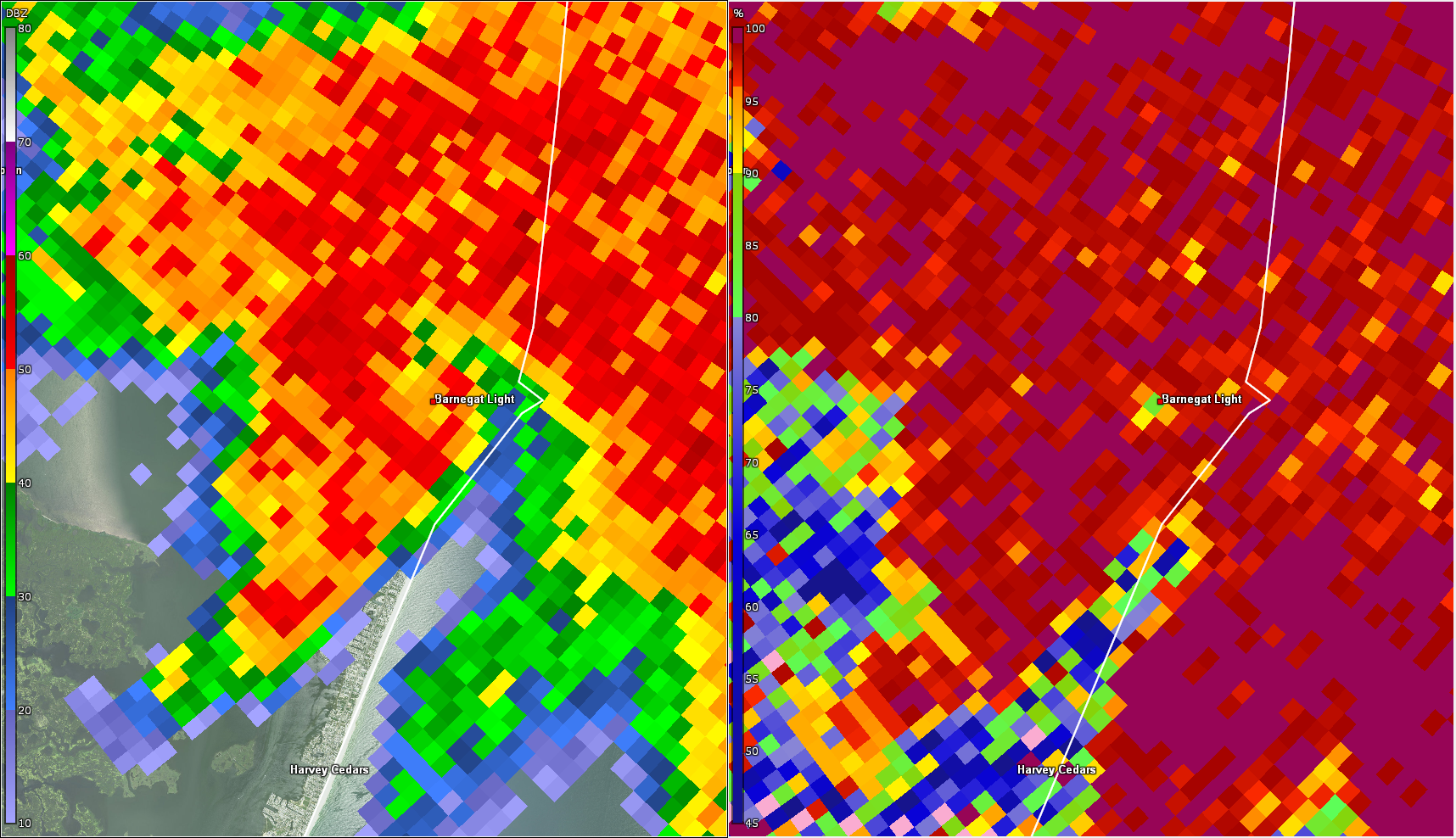
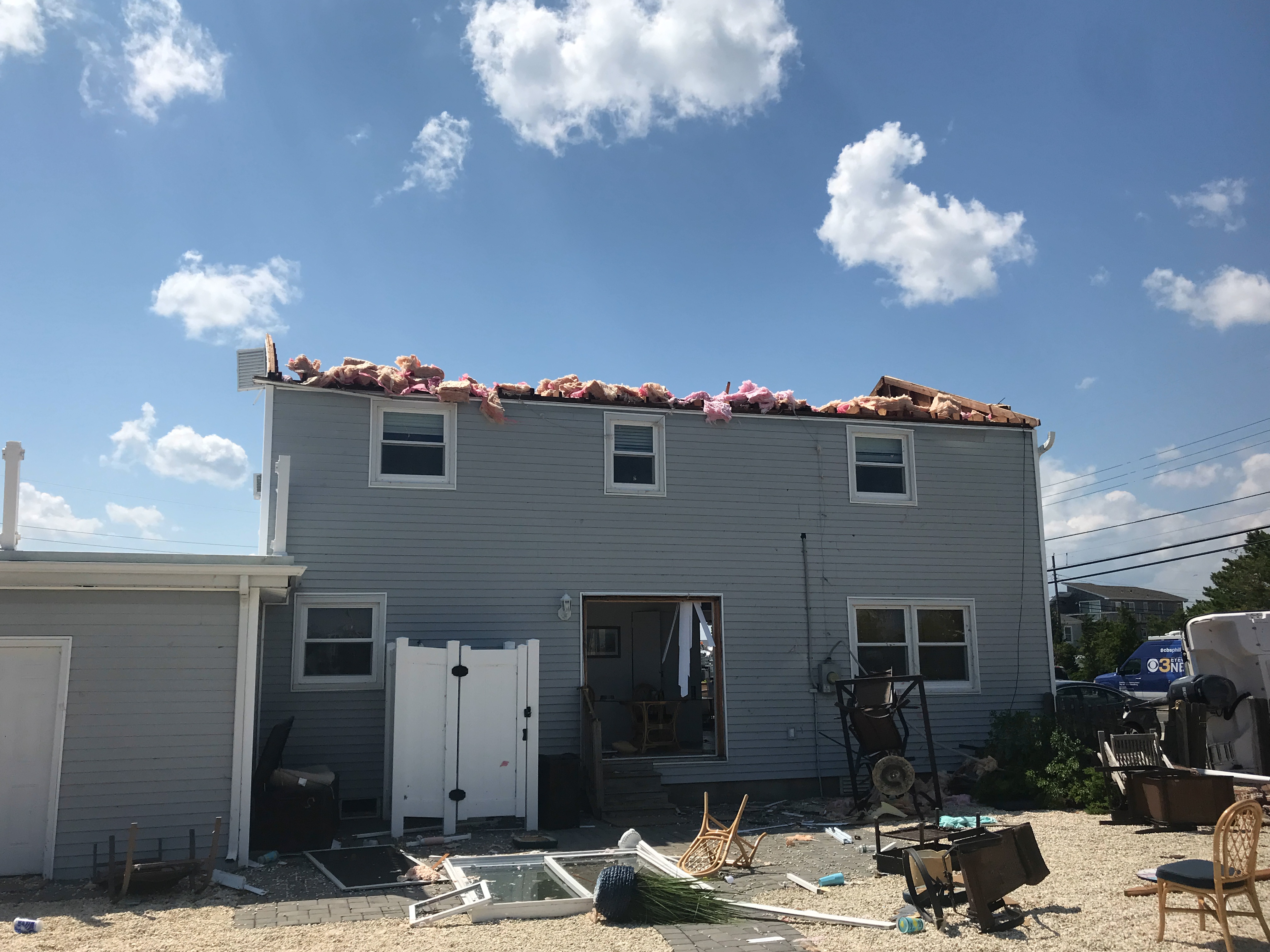
0903 PM TORNADO 2 E BARNEGAT 39.75N 74.19W
07/29/2021 OCEAN NJ NWS STORM SURVEY
THE SAME SUPERCELL WHICH PRODUCED A TORNADO
IN THE NEW JERSEY PINE BARRENS CYCLED AND
PRODUCED ANOTHER TORNADO IN FAR EASTERN
OCEAN COUNTY. THE TORNADO TOUCHED DOWN NEAR
THE IMMEDIATE WESTERN SHORE OF BARNEGAT BAY.
AT LEAST ONE BUILDING NEAR BAY BEACH OFF
BAYSHORE DR SUSTAINED ROOFING DAMAGE. THE
TORNADO THEN MOVED OVER BARNEGAT BAY AS A
WATERSPOUT. IT CAME ASHORE IN THE AREA OF
HIGH BAR HARBOR IN LONG BEACH TWP. THE MOST
SEVERE DAMAGE WAS NOTED TO A HOUSE ON THE
CORNER OF ANTIOCH RD AND ARNOLD BLVD. THIS
HOUSE WAS FACING WEST-SOUTHWEST, AND HAD ITS
ENTIRE ROOF STRUCTURE LIFTED OFF AND TOSSED
ONE TO TWO HOUSES TO THE EAST. THE HOUSE
WALLS REMAINED STANDING BUT MOST OF THE
DOORS AND WINDOWS ON THE EAST AND WEST SIDES
OF THE HOUSE WERE COMPLETELY BLOWN OUT, WITH
SIGNIFICANT DAMAGE TO THE INSIDE OF THE
HOUSE. A TWO- BY-FOUR FROM AN ADJACENT HOUSE
IMPALED THE WALL ON THE WEST SIDE OF THE
HOUSE. EIGHT PEOPLE WERE IN THE HOUSE AT THE
TIME THE TORNADO HIT, BUT THEY WERE ABLE TO
TAKE SHELTER IN AN INTERIOR CLOSET, WITH
ONLY MINOR INJURIES SUSTAINED. IN ADDITION,
ON THE NORTH SIDE OF THE HOUSE, A CAR IN THE
DRIVEWAY WAS PUSHED SIDEWAYS SEVERAL FEET
AND THEIR BOAT FLIPPED INTO THEIR NEIGHBORS
BOAT. THE BOATS TRAILER WAS TOSSED ABOUT 50
FEET INTO A HOUSE JUST TO THE EAST. THE
DEGREE AND ORIENTATION OF DAMAGE WAS
CONSISTENT WITH TORNADIC WINDS OF 115 TO 120
MPH, WHICH IS EF2 INTENSITY. CONTINUING
EAST-NORTHEAST, ABOUT A DOZEN HOMES ON THE
SOUTH SIDE OF ARNOLD BLVD SUSTAINED
SIGNIFICANT UPLIFT OF ROOF MATERIAL, SIDING
DAMAGE OR REMOVAL, COLLAPSE OF PORCH, PATIO,
AND SUNROOM STRUCTURES, AND BLOWN OUT
WINDOWS. SEVERAL LARGE TREES WERE UPROOTED
AND LAY POINTING TO THE EAST-NORTHEAST, AS
WELL AS DOWNED POWER POLES. THE TORNADO
MOVED EAST OR SLIGHTLY NORTH OF EAST FROM
ARNOLD BLVD, OVER AN OPEN SALT MARSH, BEFORE
INTERSECTING A FEW HOUSES ON THE CORNER OF
COLLIER RD AND SUNSET BLVD. THE MOST
SIGNIFICANT DAMAGE WAS TO A HOUSE ON THE
NORTHWEST CORNER OF COLLIER AND SUNSET,
WHICH SUSTAINED SIDING DAMAGE, PARTIAL ROOF
REMOVAL, BLOWOUT OF THE STORM SURGE WALLS ON
THE BASEMENT LEVEL OF THE ELEVATED
STRUCTURE, AND A LARGE TREE UPROOTED AND
LAYING TO THE EAST-NORTHEAST. POWER POLES
AND LARGE TREES WERE DOWNED ON SUNSET BLVD,
ADJACENT TO THE HIGH BAR HARBOR YACHT CLUB.
THERE WAS DAMAGE TO SEVERAL BOATS IN THE
YACHT CLUB MARINA, BUT THIS WAS MAINLY DUE
TO LOFTED DEBRIS BEING TOSSED INTO THE
MARINA. THE CIRCULATION THEN MOVED INTO THE
COVE EAST OF THE MARINA. HOWEVER, NO FURTHER
SIGNIFICANT DAMAGE WAS NOTED ON THE EAST
SIDE OF THE COVER IN BARNEGAT LIGHT,
INDICATING THE TORNADO HAD LIKELY LIFTED.
THIS IS CORROBORATED BY RADAR DATA WHICH
SHOWED A WEAKENING OF THE CIRCULATION AND A
LIKELY DISSIPATION BEFORE IT CROSSED INTO
THE OPEN ATLANTIC.
0912 PM TSTM WND DMG 1 WSW BARNEGAT LIGHT 39.75N 74.12W
07/29/2021 OCEAN NJ EMERGENCY MNGR
WIDESPREAD WIND DAMAGE IN HIGH BAR HARBOR. A
ROOF WAS TORN OFF A BUILDING, BOATS WERE
OVERTURNED, UTILITY POLES WERE TOPPLED AND
THERE WAS MUCH DEBRIS ON LOCAL ROADWAYS. A
POSSIBLE TORNADO.
0916 PM TSTM WND GST 1 E BARNEGAT LIGHT 39.76N 74.10W
07/29/2021 M44 MPH ANZ451 NJ MESONET
0919 PM FLASH FLOOD CRANBURY 40.33N 74.51W
07/29/2021 MIDDLESEX NJ TRAINED SPOTTER
NORTH MAIN STREET COMPLETELY FLOODED BETWEEN
RT-130 AND OLD CRANBURY RD. BECOMING
IMPASSABLE.
&&
$$
Public Information Statement
NOUS41 KPHI 151258
PNSPHI
DEZ001>004-MDZ012-015-019-020-NJZ001-007>010-012>027-PAZ054-055-
060>062-070-071-101>106-160100-
Public Information Statement
National Weather Service Mount Holly NJ
858 AM EDT Sun Aug 15 2021
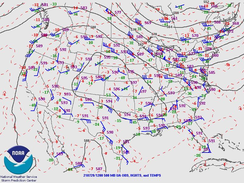
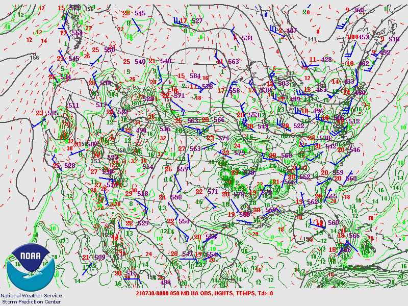
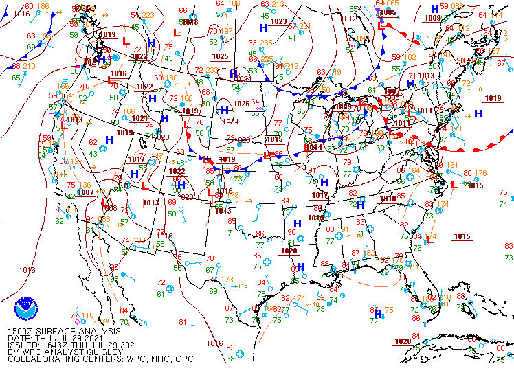
...NWS Damage Surveys for 07/29/2021 Tornado Outbreak - Update #6...
The National Weather Service office in Mount Holly, NJ had a
total of 6 survey teams investigate damage across the region,
which resulted from several severe thunderstorms on Thursday,
July 29th. A total of 10 tornadoes occurred in our region as a
result of this outbreak. The details of each tornado, and
some straight line wind events, are included below.
**Changes with this Update**
-Added a 10th tornado which occurred in a portion of Jackson
Township, Ocean County NJ (see last tornado listed below).
.Somerton-Trevose-Bensalem PA Tornado...
Rating: EF-3
Estimated Peak Wind: 140 mph
Path Length /statute/: 3.5 miles
Path Width /maximum/: 530 yards (0.3 miles)
Fatalities: 0
Injuries: 5
Start Date: July 29, 2021
Start Time: 7:04 PM EDT
Start Location: Somerton / Philadelphia / PA
Start Lat/Lon: 40.130/-75.005
End Date: July 29, 2021
End Time: 7:12 PM EDT
End Location: Bensalem / Bucks / PA
End Lat/Lon: 40.130/-74.941
The Somerton-Trevose-Bensalem tornado began in Somerton in
Philadelphia County near Southampton Road, Kelvin Avenue, and
Trevose Road where it uprooted and blew down large limbs from a
few softwood and hardwood trees. The tornado crossed County Line
Road into Trevose in Bucks County where a large tree was
uprooted. The tornado continued between Trevose Road and Peyton
Street where additional tree damage occurred before crossing
Lukens Street. The tornado then very briefly crossed back into
Philadelphia County at the northern tip of Poquessing Valley Park
where a few trees were uprooted. The tornado then crossed back
into Trevose in Bucks County where it caused some minor cosmetic
damage to some homes in the Beechwood Estates neighborhood and
blew down several sections of vinyl fencing. Several small trees
were also snapped or uprooted in and just south and east of the
residential neighborhood.
As the tornado approached Somerton Road, it began intensifying
and widening substantially as it moved into the Metropolitan
Industrial Center. Numerous softwood and hardwood trees were
snapped or uprooted in the SUEZ Water Company property southwest
of and along Somerton Road. Five wooden power poles were snapped
near the ground along Somerton Road as well at the northern end
of the SUEZ property. All seven warehouse buildings in the
industrial complex northeast of Somerton Road sustained at least
minor damage, with the most significant occurring to the Northtec
building. Numerous roof mounted HVAC units were shifted or blown
off of a few of the buildings in the industrial complex. Open bay
doors in the western- most building caused a non-load bearing
interior wall to collapse. A sedan was lifted and flipped over in
the Northtec parking lot and a steel flag pole bearing a flag
flattened completely to the ground. The Northtec building
sustained substantial structural damage where large sections of
roofing material were removed. Additionally, numerous exterior
paneling was blown off, garage bay doors were blown out, a few
windows were blown out, and at least two large HVAC units were
blown off of the building. Numerous softwood and hardwood trees
were uprooted or snapped in the industrial complex and immediately
adjacent areas.
Southeast of the industrial complex, minor cosmetic damage
occurred to some homes along Carter Road in a residential
neighborhood. Tree damage associated with the tornado occurred
along Carter Road and Sussex Road north of Buckfield Terrace.
This was the area where the tornado circulation reached its widest
extent of around three tenths of a mile. As the tornado neared
and crossed the Pennsylvania Turnpike (I- 276), an overhead
roadway information sign was blown off and a portion of it landed
downstream nearly a half mile away. Just north of the turnpike,
minor cosmetic damage occurred to a hotel building where a tree
was also uprooted in the parking lot. A large billboard was blown
over just north of the turnpike and south of Street Road. A small
utility building nearby had its roof blown off. The northern- most
extent of the damage occurred on the Toscana 52 restaurant
property where the tornado blew down some chain link fencing and
uprooted a few small trees in the parking lot.
The tornado continued east-northeastward across Street Road
toward the Faulkner car dealership complex where it began
intensifying and somewhat narrowing its path of damage. The four
dealership showrooms sustained significant damage where most
windows were blown out and at least some roofing material was
blown off. The most significant damage occurred to the Buick/GMC
showroom where most of the roofing material was blown off, all
windows and doors were blown out, and exterior walls exhibited
fracturing due to stress from the wind. Roof HVAC units of this
building were tossed into the parking lot behind the building.
All of the dealership signs near the main road were destroyed.
Scores of new and used vehicles sustained significant damage from
flying debris or from being pushed or tossed trough the air.
The tornado continued toward the dealership's main service garage
where the most significant damage occurred. The southwestern
portion of the building was destroyed with most exterior walls
collapsing completely and all roofing material blown off.
Interior walls mostly remained standing. Roof HVAC units were
tossed off of the building with one unit landing nearly 200 yards
downstream of the building. Damage sustained to the building
decreased somewhat toward the eastern end of it where portions of
the exterior walls were damaged and almost all garage bay doors
were blown out. The wind rushing through the garage area carried
debris, car parts, and tools well away from the structure
downstream. Some vehicles near the main garage building were
completely destroyed from large pieces of flying debris or from
being tossed and dropped back onto the ground. A small pickup
truck was crushed from a collapsed exterior wall. Five people
reportedly sustained minor injuries at the dealership complex.
The tornado continued east-northeast toward the Weisser Homes
mobile home park and into an area of trees which sustained
significant damage. Most tree canopies and limbs were completely
stripped from the still standing or snapped trunks of hardwood
trees in this area. A large storage container filled with car
parts from the service garage parking lot upstream was lofted
into the air and dropped into this area of trees. An uninhabited
mobile home model was lifted and completely destroyed at the
mobile home park. Another double-wide mobile home had a large
portion of its roof blown off. Several other mobile home sustained
varying degrees of damage as well. A large amount of various
debris from the dealership complex landed in this mobile home
park. Numerous softwood and hardwood trees near and just
downstream of this area were snapped or uprooted along Old Lincoln
Highway.
At this stage, the tornado damage path narrowed considerably and
intensity weakened significantly as it crossed Old Lincoln
Highway and moved toward the Lowe's and Walmart shopping centers
on Route 1. The tornado passed over these shopping centers, but no
structural damage was noted to these structures. Numerous small
trees were snapped and uprooted in the large parking lot area and
line of trees just north of the Bensalem turnpike interchange.
Some exit ramp signs were blown down in the interchange area.
The tornado damage became somewhat discontinuous as it continued
east-southeast into Bensalem across Route 1 and toward a
residential neighborhood. Several homes in the neighborhood
sustained loss of some roofing material and other cosmetic damage
in addition to some tree damage. The tornado continued across
Rockhill Road and along Richlieu Road toward the Christian Life
Center where several trees were snapped or uprooted. The church's
steeple had some paneling blown off, but the steeple itself was
not damaged otherwise. The tornado continued weakening as it
crossed Galloway Road then dissipated in the Bensalem Township
Community Park where some minor tree damage occurred.
No known serious injuries or fatalities occurred from this
tornado.
The National Weather Service survey team would like to thank the
Bucks County Emergency Management Agency and Pennsylvania
Emergency Management Agency for their assistance with this
survey.
.Windsor-Robbinsville NJ Township Tornado...
Rating: EF-1
Estimated Peak Wind: 105 mph
Path Length /statute/: 1.6 miles
Path Width /maximum/: 100 yards
Fatalities: 0
Injuries: 0
Start Date: July 29, 2021
Start Time: 6:56 PM EDT
Start Location: Robbinsville Twp / Mercer / NJ
Start Lat/Lon: 40.237/-74.585
End Date: July 29, 2021
End Time: 7:05 PM EDT
End Location: Robbinsville Twp / Mercer / NJ
End Lat/Lon: 40.239/-74.554
The Windsor-Robbinsville Township tornado began on Route 130 just
south of the town of Windsor near the Assunpink Creek. A few
hardwood trees were uprooted along the highway near the Chestnut
Montessori. The building lost a portion of its roofing material
and several other hardwood trees were uprooted or snapped just
behind the property into a small wooded area. The tornado then
continued in a somewhat transient and weak manner through a series
of fields and tree lines. A few large tree branches were snapped
off near a farm home on Windsor Road and a hardwood tree in a tree
line was uprooted across the street. The sporadic tree damage
continued along Perrineville Road where a large section of a tree
was snapped off at another residence. The tornado then produced an
area of intense convergent tree damage near the intersection of
Perrineville Road and Voelbel Road where numerous trees were
snapped or uprooted. The tornado ended just downstream from this
intersection at a residence on Perrineville Road where a final
tree was uprooted.
The National Weather Service would like to thank the Mercer
County Office of Emergency Management for their assistance in
providing information for this survey.
.Plumstead Twp PA Tornado...
Rating: EF-1
Estimated Peak Wind: 90 mph
Path Length /statute/: 2.6 miles
Path Width /maximum/: 70 yards
Fatalities: 0
Injuries: 0
Start Date: July 29, 2021
Start Time: 5:40 PM EDT
Start Location: Plumstead Twp / Bucks / PA
Start Lat/Lon: 40.393/-75.106
End Date: July 29, 2021
End Time: 5:45 PM EDT
End Location: Plumstead Twp / Bucks / PA
End Lat/Lon: 40.367/-75.068
Tree damage began in the area of Bradshaw Rd in Plumstead Twp in
Bucks County, where a few sizable limbs were downed and a couple
of larger but weakened trees were snapped. The tornado then
entered a cornfield near the intersection of Ferry Rd and Point
Pleasant Pike. Some degree of convergence was noted in a narrow
path of downed corn, though it was not overly strong. In addition,
some trees adjacent to and southeast of the cornfield were also
damaged. The damage became more substantial with a clearer
rotation signature observed in the area of Ridgeview Dr, where a
number of trees were snapped, favoring higher elevation areas
along a ridge line. The snapping and shearing of trees in that
area and the nature of the debris field strongly indicated
tornadic damage, with the magnitude of damage meriting an EF1
rating. The tornado continued southeastward through Carversville
Rd and to the area of Long Ln in Buckingham Twp. Several
residences along and near Long Ln sustained tree damage. The
tornado impacted Maximuck's Farm Market on Long Ln, where
greenhouses sustained roof damage and some uplift of their frames.
Some convergence was also noted in crop fields on the property.
Just southeast of the greenhouses, a barn on the property was
heavily damaged with a partial collapse of its walls. However,
just beyond the barn, a large stretch of cornfields and a tree
line beyond the cornfields were left untouched, indicating the
tornado lifted near the damaged barn.
The National Weather Service would like to thank the Bucks County
Emergency Management Agency and the Pennsylvania Emergency
Management Agency for their assistance in completing this survey.
.New Hope PA to Hopewell Twp NJ Tornado...
Rating: EF-2
Estimated Peak Wind: 120 mph
Path Length /statute/: 6.4 miles
Path Width /maximum/: 400 yards
Fatalities: 0
Injuries: 0
Start Date: July 29, 2021
Start Time: 5:59 PM EDT
Start Location: New Hope / Bucks / PA
Start Lat/Lon: 40.345/-74.948
End Date: July 29, 2021
End Time: 6:14 PM EDT
End Location: Hopewell Twp / Mercer / NJ
End Lat/Lon: 40.297/-74.846
The supercell storm which produced a tornado in Plumstead Twp
cycled and produced another tornado beginning in New Hope in
Bucks County, Pennsylvania. Tree damage began near River Rd just
west of the Delaware River, with a portion of River Rd closed and
impassable due to downed trees. The tornado crossed the Delaware
River and entered Mercer County, New Jersey, in the area of
Washington Crossing. Multiple reports of residential tree damage
were received from Washington Crossing, and the survey team
observed tree damage along River Rd on the New Jersey side of the
Delaware River. From there the tornado continued southeast and
crossed Pleasant Valley Rd. The first indications of EF2 damage
came on that road, with numerous large hardwood and softwood trees
snapped, sheared, and/or uprooted. The tornado continued
southeastward and crossed through Baldpate Mountain. Continued
heavy tree damage was observed in this area. An access road to the
top of the mountain was barely passable when the survey team
reached it in late afternoon, after many hours of tree clearing
work by local parks officials and private companies. Hundreds of
trees were snapped or damaged on this mountain. Damage continued
down the mountain through Fiddlers Creek Rd and Church Rd. The
tornado path then crossed Washington Crossing State Park. Further
damage was observed just southeast along Bear Tavern Rd. In fact,
some of the largest downed trees were observed in this area.
However, by this point damage became increasingly unidirectional
as the storm's rear flank downdraft likely wrapped around the
tornadic circulation. Sufficient evidence of tornadic winds still
existed in the Bear Tavern Rd area, but it is estimated the
tornado lifted soon after, shortly before entering much more
densely populated areas near the Trenton Mercer Airport.
The National Weather Service would like to thank the Mercer
County Office of Emergency Management for their assistance in
completing this survey.
.Northeast Philadelphia PA Tornado...
Rating: EF-0
Estimated Peak Wind: 80 mph
Path Length /statute/: 0.46 miles
Path Width /maximum/: 40 yards
Fatalities: 0
Injuries: 0
Start Date: July 29, 2021
Start Time: 7:07 PM EDT
Start Location: Bustleton / Philadelphia / PA
Start Lat/Lon: 40.082/-75.033
End Date: July 29, 2021
End Time: 7:08 PM EDT
End Location: Bustleton / Philadelphia / PA
End Lat/Lon: 40.080/-75.025
A brief tornado occurred in the Bustleton section of Northeast
Philadelphia. Damage was first observed near Grant Ave at the
Grant Gardens apartment complex, where some minor loss of roofing
material was noted and debris was tossed in a chaotic manner
consistent with tornadic winds. The tornado moved east-southeast
across Roosevelt Blvd. Continued minor structural damage was noted
along a narrow path, mainly consisting of sporadic losses of
siding and insulation. Minor tree damage was also noted. One
building also had ceiling tiles pulled downward with insulation
removed in a car park area, a strong indicator of tornadic
pressure gradient forces. Near Blue Glass Rd, a couple of slightly
larger trees had their trunks snapped, and winds of around 80 mph
likely occurred in that area. The damage path ended near there,
however, after a track length of only around half a mile. Radar
data indicates this was an anticyclonic tornado.
The National Weather Service would like to thank the Philadelphia
Office of Emergency Management for their assistance in completing
this survey.
.Slatington PA Tornado...
Rating: EF-1
Estimated Peak Wind: 100 mph
Path Length /statute/: 2.0 miles
Path Width /maximum/: 75 yards
Fatalities: 0
Injuries: 0
Start Date: July 29, 2021
Start Time: 4:25 PM EDT
Start Location: Slatington / Lehigh / PA
Start Lat/Lon: 40.758/-75.624
End Date: July 29, 2021
End Time: 4:29 PM EDT
End Location: Slatington / Lehigh / PA
End Lat/Lon: 40.765/-75.604
This tornado initially caused considerable tree damage on
Welshtown Road and Skeet Club Lane including multiple uprooted
hardwood trees. It continued on the grounds of Northern Lehigh
High School in Slatington. Several trees were snapped or uprooted
at the athletic fields of the high school, with most of the
snapping occurring high up in the trees. A wooden dugout on the
school's baseball field lost its roof, and some unanchored metal
bleachers were tossed. Damage was mostly blown in a similar west
to east direction, but there was some evidence of convergence
especially in tree damage in the area. In a neighborhood east of
the high school, a tree was snapped about one third of the way up
the trunk. At the Slatington Airport, an airplane hangar door was
blown out and there was tree damage on the airport property.
Damage became more unidirectional near the airport as the
circulation likely gusted out. Little if any damage occurred east
of the airport property, and that is where the tornado path is
estimated to have ended.
This path is still considered preliminary as we will be reviewing
high resolution satellite data to aid in the identification of
the start and end locations.
The National Weather Service would like to thank Mr. Lou Ruh for
his assistance in completing this survey and residents of the area
for their reports and pictures which further helped with the
assessment.
.Kempton to Weisenberg Twp PA Tornado...
Rating: EF-1
Estimated Peak Wind: 90 mph
Path Length /statute/: 2.8 miles
Path Width /maximum/: 90 yards
Fatalities: 0
Injuries: 0
Start Date: July 29, 2021
Start Time: 4:04 PM EDT
Start Location: Kempton / Berks / PA
Start Lat/Lon: 40.611/-75.807
End Date: July 29, 2021
End Time: 4:09 PM EDT
End Location: Weisenberg Twp / Lehigh / PA
End Lat/Lon: 40.622/-75.754
A tornado touched down near Turkey Rd in Kempton, Albany Twp,
Berks County, PA, just west of the border with Lehigh County.
About 15 trees were uprooted in the area of Turkey Rd with a
convergent damage pattern noted in multiple nearby corn fields.
The path continued to between Kunkels Mill Rd and Red Rd near the
far southern tip of Lynn Twp in Lehigh County. Mostly minor crop
and tree damage was observed in this area, but with a continued
clear convergent pattern. A resident on Red Rd filmed the tornado
as it passed to his south. The tornado passed through an open
field before crossing Rhoads Rd, where tree and minor roofing
damage were sustained. East of Rhoads Rd, a number of trees were
snapped and uprooted as the tornado approached New Smithville Rd.
The tornado crossed Golden Key Rd, uprooting a few more trees,
before dissipating in a field prior to reaching Loch Valley Rd in
Weisenberg Twp. The extent of tree damage both near the start of
the path in Kempton and in the New Smithville Rd area merited an
EF1 rating.
The National Weather Service would like to thank Mr. Lou Ruh, Mr.
Justin Selig, and several members of the general public for their
assistance in completing this survey.
.Woodland Twp to Wells Mills NJ Tornado...
Rating: EF-1
Estimated Peak Wind: 105 mph
Path Length /statute/: 6.6 miles
Path Width /maximum/: 250 yards
Fatalities: 0
Injuries: 0
Start Date: July 29, 2021
Start Time: 8:42 PM EDT
Start Location: Woodland Twp / Burlington / NJ
Start Lat/Lon: 39.775/-74.397
End Date: July 29, 2021
End Time: 8:51 PM EDT
End Location: Wells Mills / Ocean / NJ
End Lat/Lon: 39.795/-74.277
A tornado touched down on the evening of July 29 in a heavily
forested area in the eastern portion of Woodland Twp in southern
New Jersey. The start location is estimated to be between
Stevenson Rd, where survey crews found no damage, and Whiting Rd
about a mile and a half away, where tree damage was observed. The
estimate, also aided by radar, places the start just west of the
border of Burlington and Ocean Counties. After touching down, the
tornado moved in an east-northeasterly direction. The bulk of the
damage consisted of large snapped and uprooted pine and spruce
trees with a few red maple trees. The orientation of the damage
combined with radar signatures clearly indicated the damage was
produced by a tornado. Some of the heaviest damage occurred on Old
Cedar Bridge Rd near the Cedar Bridge Tavern Historic Site. The
tornado crossed Route 72 before moving through over a mile of
inaccessible forest land. Tree damage was found again along Jones
Rd. From there the tornado moved into the Wells Mills area where
the path of tree damage continued. A number of snapped trees and
large limbs were found in the area of Wells Mills County Park. The
tornado path appeared to end a few hundred yards east of this
location. The degree of tree damage along the middle portion of
the track was consistent with a higher end EF1 tornado.
The National Weather Service would like to thank the Ocean County
Sheriff's Office, Ocean County Emergency Management, Ocean County
Parks, and Mr. Marc Franz Jr for their assistance in completing
this survey. The NWS in Mount Holly also extends its appreciation
to Mr. Nelson Vaz of NWS New York for his assistance on this
damage survey.
.Barnegat to High Bar Harbor NJ Tornado...
Rating: EF-2
Estimated Peak Wind: 115 to 120 mph
Path Length /statute/: 4.2 miles
Path Width /maximum/: 75 yards
Fatalities: 0
Injuries: A few minor
Start Date: July 29, 2021
Start Time: 9:03 PM EDT
Start Location: Barnegat / Ocean / NJ
Start Lat/Lon: 39.754/-74.191
End Date: July 29, 2021
End Time: 9:13 PM EDT
End Location: High Bar Harbor / Ocean / NJ
End Lat/Lon: 39.754/-74.112
The same supercell which produced a tornado in the New Jersey
Pine Barrens cycled and produced another tornado in far eastern
Ocean County. The tornado touched down near the immediate western
shore of Barnegat Bay. At least one building near Bay Beach off
Bayshore Dr sustained roofing damage. The tornado then moved over
Barnegat Bay as a waterspout. It came ashore in the area of High
Bar Harbor in Long Beach Twp.
The most severe damage was noted to a house on the corner of
Antioch Rd and Arnold Blvd. This house was facing west-southwest,
and had its entire roof structure lifted off and tossed one to two
houses to the east. The house walls remained standing but most of
the doors and windows on the east and west sides of the house
were completely blown out, with significant damage to the inside
of the house. A two- by-four from an adjacent house impaled the
wall on the west side of the house. Eight people were in the house
at the time the tornado hit, but they were able to take shelter
in an interior closet, with only minor injuries sustained. In
addition, on the north side of the house, a car in the driveway
was pushed sideways several feet and their boat flipped into their
neighbor's boat. The boat's trailer was tossed about 50 feet into
a house just to the east. The degree and orientation of damage
was consistent with tornadic winds of 115 to 120 mph, which is EF2
intensity.
Continuing east-northeast, about a dozen homes on the south side
of Arnold Blvd sustained significant uplift of roof material,
siding damage or removal, collapse of porch, patio, and sunroom
structures, and blown out windows. Several large trees were
uprooted and lay pointing to the east-northeast, as well as downed
power poles.
The tornado moved east or slightly north of east from Arnold
Blvd, over an open salt marsh, before intersecting a few houses on
the corner of Collier Rd and Sunset Blvd. The most significant
damage was to a house on the northwest corner of Collier and
Sunset, which sustained siding damage, partial roof removal,
blowout of the storm surge walls on the basement level of the
elevated structure, and a large tree uprooted and laying to the
east-northeast. Power poles and large trees were downed on Sunset
Blvd, adjacent to the High Bar Harbor Yacht Club. There was damage
to several boats in the yacht club marina, but this was mainly
due to lofted debris being tossed into the marina. The circulation
then moved into the cove east of the marina. However, no further
significant damage was noted on the east side of the cover in
Barnegat Light, indicating the tornado had likely lifted. This is
corroborated by radar data which showed a weakening of the
circulation and a likely dissipation before it crossed into the
open Atlantic.
The National Weather Service would like to thank the Ocean County
Sheriff's Office, Ocean County Emergency Management, and United
States Coast Guard Station Barnegat Light for their assistance in
completing this survey. The NWS in Mount Holly also extends its
appreciation to Mr. Nelson Vaz of NWS New York for his assistance
on this damage survey.
.Jackson Twp NJ Tornado...
Rating: EF-0
Estimated Peak Wind: 80 mph
Path Length /statute/: 0.76 miles
Path Width /maximum/: 80 yards
Fatalities: 0
Injuries: 0
Start Date: July 29, 2021
Start Time: 8:04 PM EDT
Start Location: Jackson Twp / Ocean / NJ
Start Lat/Lon: 40.047/-74.428
End Date: July 29, 2021
End Time: 8:08 PM EDT
End Location: Jackson Twp / Ocean / NJ
End Lat/Lon: 40.047/-74.414
The tornado touched down east of Hawkin Road near the intersection
of Bordens Mill Branch and Success Branch in Jackson Township. The
entire life cycle of this tornado was within a large wooded area
between Success Lake and the Lakehurst Naval Air Field. Based on
aerial images, the damage was limited to some snapped and uprooted
trees. The tornado occurred about 7 miles north of the Fort Dix
Doppler Radar (KDIX), which showed a well defined velocity couplet
along with a Tornado Debris Signature (TDS) in the Correlation
Coefficient data. The radar data showed the circulation was short-
lived as it moved eastward across the extensive wooded area
southwest of Success Lake. Based on the aerial images, this tornado
was rated an EF-0 with estimated peak winds up to 80 mph given the
damage to numerous softwood trees.
The National Weather Service would like to thank the New Jersey
Civil Air Patrol (CAP) for their extensive assistance by flying
aerial surveys to find damage produced by this tornado.
.Silverton NJ (Ocean County) Wind Event...
A damaging wind event occurred in the Silverton section of Toms
River, New Jersey. The area was surveyed by a National Weather
Service storm survey team. Multiple areas of minor tree and siding
damage were observed roughly along a path from near Alissa Dr to
Arkansas Ave. The most significant damage occurred in the area of
Silverton Park near the Silverton EMS building. One large tree was
snapped on the north side of Silverton Park near Maine St, and a
couple of other trees nearby lost limbs. A small section of siding
was also removed from the EMS building just across the street.
Sporadic, minor tree damage continued along a path east-
northeastward from there before ending in the area of Green
Island. Radar indicated some weak rotation in the area. Dual
polarization data indicated a feature which looked similar to a
tornado debris signature, but is thought more likely to be a radar
artifact based on further analysis. While it cannot be ruled out
that a brief tornado touched down, there is insufficient evidence
to confirm this. Therefore, the Silverton Wind Event has been
classified as straight line wind damage of around 60 to 70 mph.
.Sussex County DE Thunderstorm Wind Damage...
A supercell thunderstorm impacted the eastern portions of Sussex
County, DE in the early afternoon hours of July 29th. The National
Weather Service investigated reports of damage in this area. A
survey was conducted along a path of radar-indicated rotation from
the north side of Indian River Bay near Long Neck and Angola to
the area of Ocean View, north of Bethany Beach, on the eastern
side of the bay. Minor tree damage was found in the area of
Hollymount Rd, with small to medium sized tree limbs downed. A
couple of sand dunes were observed as having sand displaced from
west to east near Indian River. No visible damage was found in the
narrow stretch of land on the east side of the bay. Video
evidence exists of a waterspout produced by this thunderstorm over
the open Atlantic. However, there is no indication the waterspout
touched down over Indian River Bay or at any point before moving
over open water. Therefore, combined with the minor and
inconclusive tree damage, this is classified as a straight line
wind event with winds of around 60 mph.
&&
EF Scale: The Enhanced Fujita Scale classifies tornadoes into the
following categories:
EF0...Weak......65 to 85 mph
EF1...Weak......86 to 110 mph
EF2...Strong....111 to 135 mph
EF3...Strong....136 to 165 mph
EF4...Violent...166 to 200 mph
EF5...Violent...>200 mph
NOTE:
The information in this statement is preliminary and subject to
change pending final review of the events and publication in NWS
Storm Data.
$$
O'Brien/Gorse/Deal/Kruzdlo/Meola/Manning/Staarmann/Vaz/Haines


 Coastal Flood
 Marine Forecasts
 Text Products
 Climate Information
 Skywarn
 Submit Storm Report
 Weather Event Archives
 Forecast Discussion
 Emergency Managers
 Briefing Page