
Scattered strong to severe thunderstorms will persist over the central to southern High Plains this weekend with a severe weather and flash flooding threat. A late season storm will bring low elevation rain and high elevation snow to portions of California, Nevada and Oregon through the weekend. Winter Weather Advisories are in place for the Sierra for snow totals of 3-6", locally higher. Read More >
Philadelphia/Mt Holly
Weather Forecast Office
Overview
|
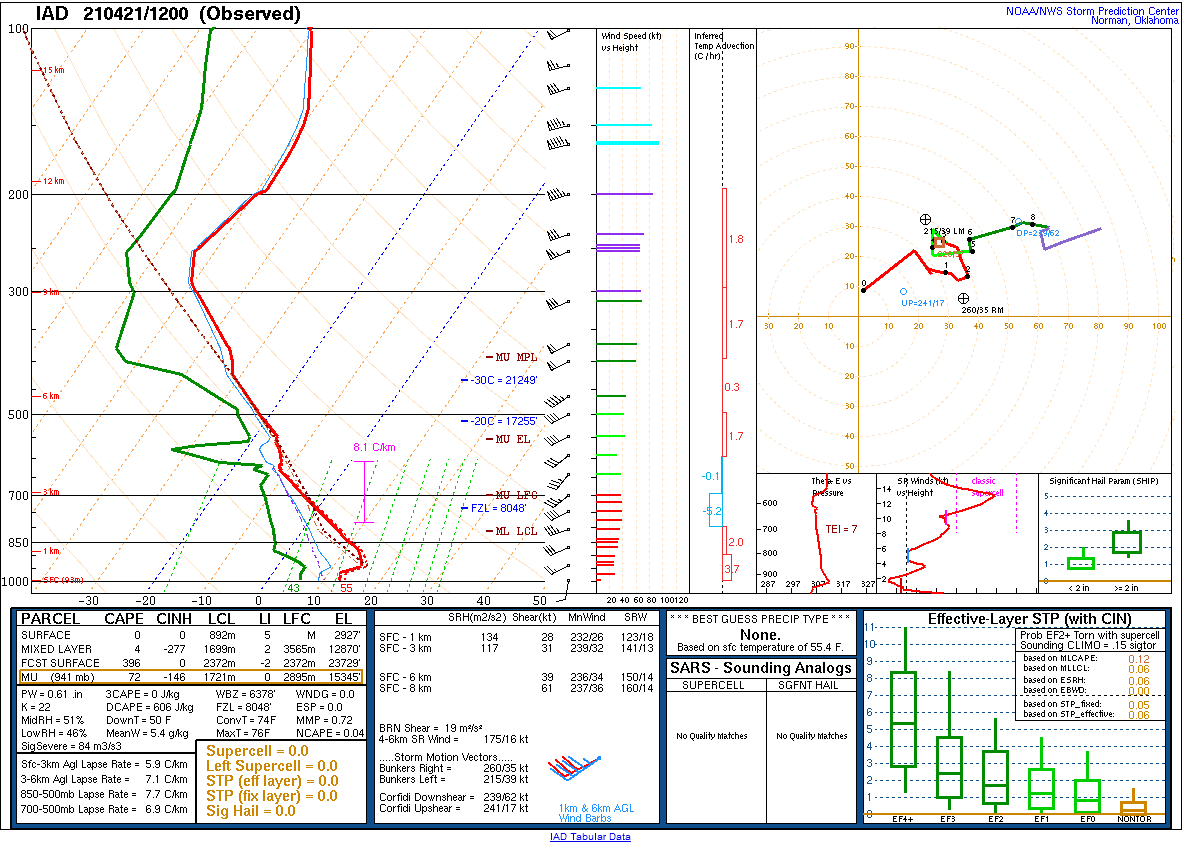
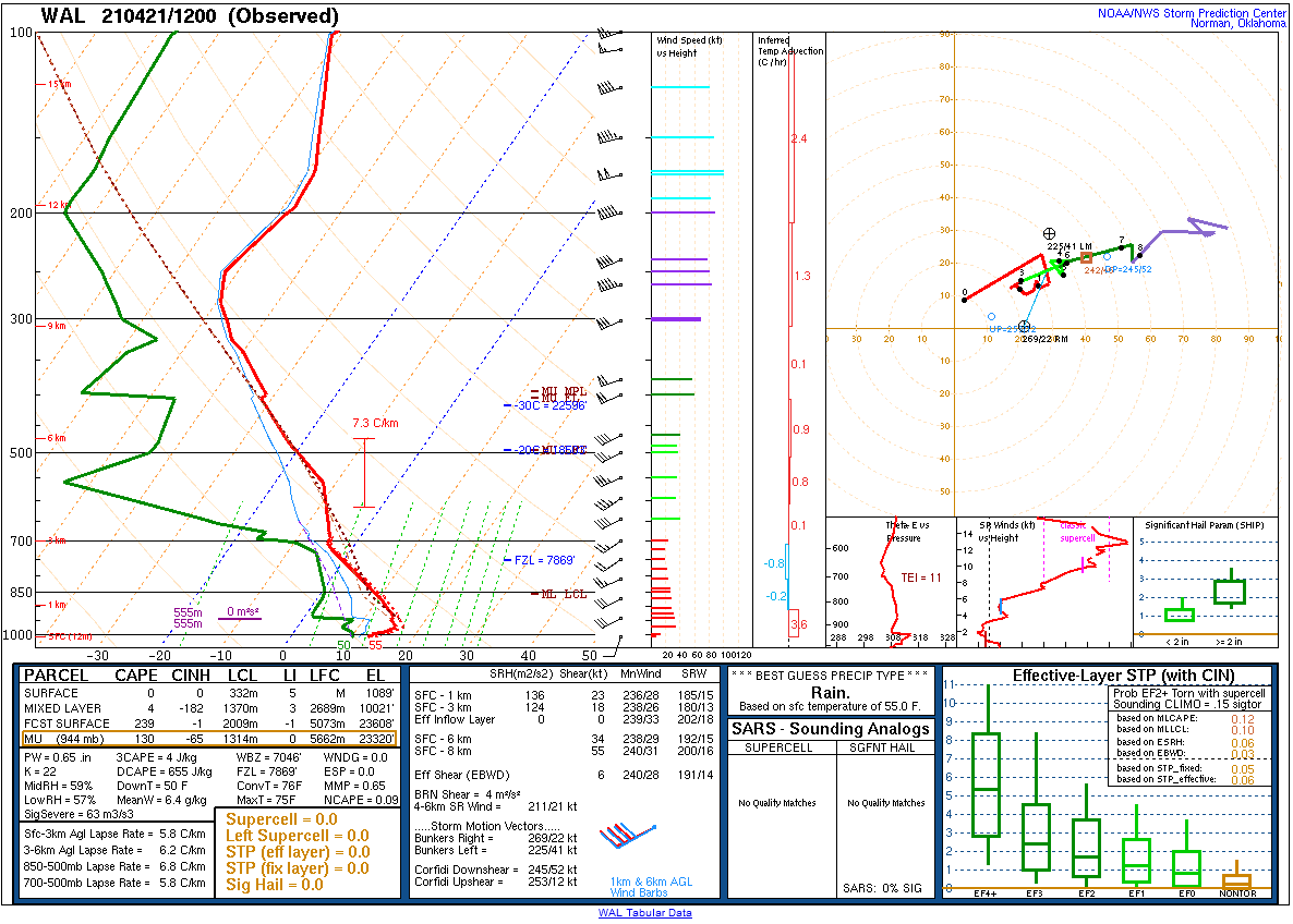
A strong cold front moved through the eastern mid-Atlantic during the early to mid afternoon hours on April 21. Showers and thunderstorms developed ahead of the front. Some storms became severe, with sporadic reports of storm damage from southern New England southward through much of the coastal mid-Atlantic. The front moved through a couple hours before peak heating, which combined with an air mass that was not overly warm to begin with limited instability. However, steep mid-level lapse rates helped to compensate for this and allowed up to around 1000J/kg of surface based CAPE to develop. Strong frontal forcing and strong shear (deep layer shear of 50 to 60 kt) combined with the sufficient instability to allow convection to develop and intensify. Mainly linear storm modes with some discrete elements were observed. The strongest storms produced hail up to quarter size, aided by cool air aloft thanks to the lapse rates, and scattered instances of downed trees and power lines due to damaging winds. Convection moved offshore by late afternoon, and a much cooler and drier air mass overspread the region. |
 KDIX radar loop of the April 21, 2021 severe weather at half hour increments from 1530 UTC to 1930 UTC. Note the rapid development between 1530 and 1600 UTC (11:30 AM - 12:00 PM EDT) and how convection consisted of a mix of discrete and linear elements, as opposed to a solid squall line such as on March 28, 2021. |
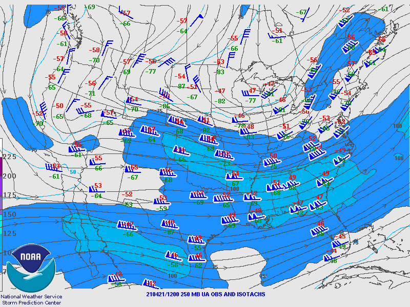
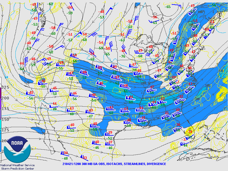
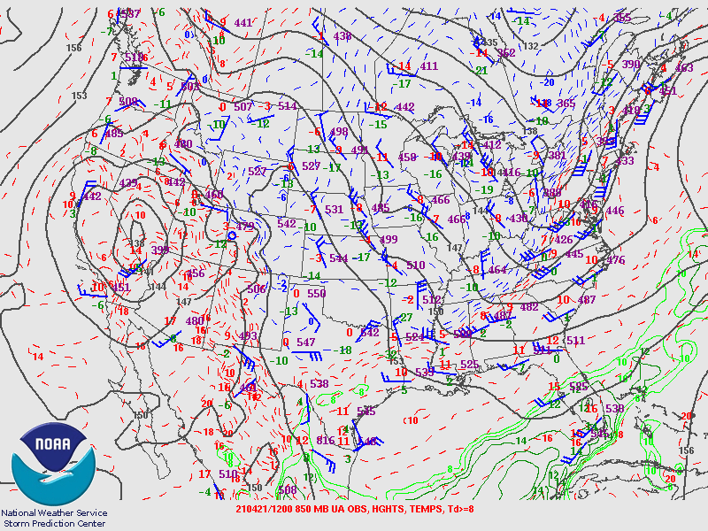
Synoptic Overview at 12z 21 April 2021 (courtesy of SPC)
 |
 |
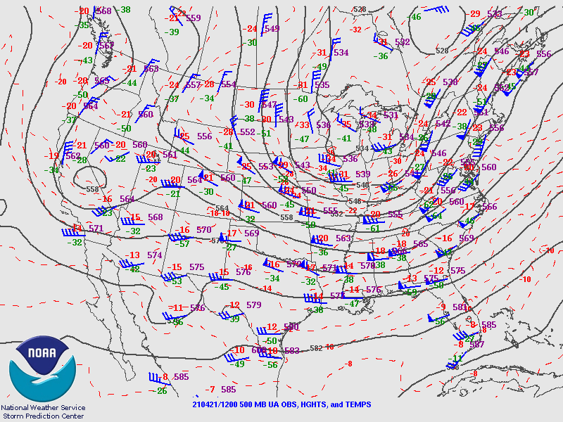 |
| Figure 1: 250-mb analysis | Figure 2: 300-mb analysis | Figure 3: 500-mb analysis |
 |
 |
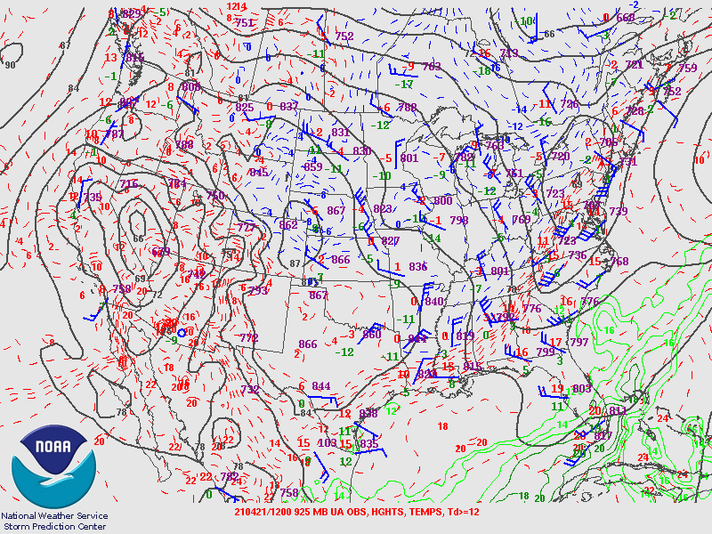 |
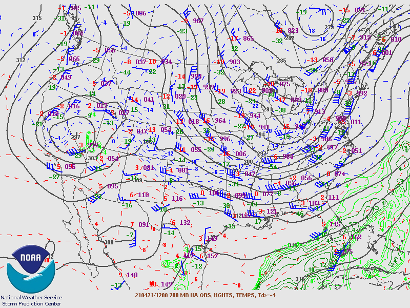
| Figure 4: 700-mb analysis | Figure 5: 850-mb analysis | Figure 6: 925-mb analysis |
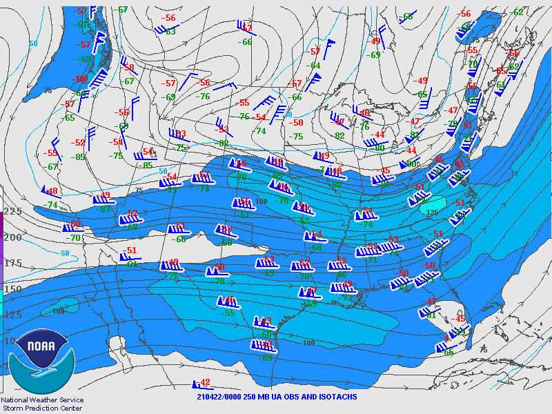
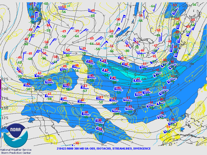
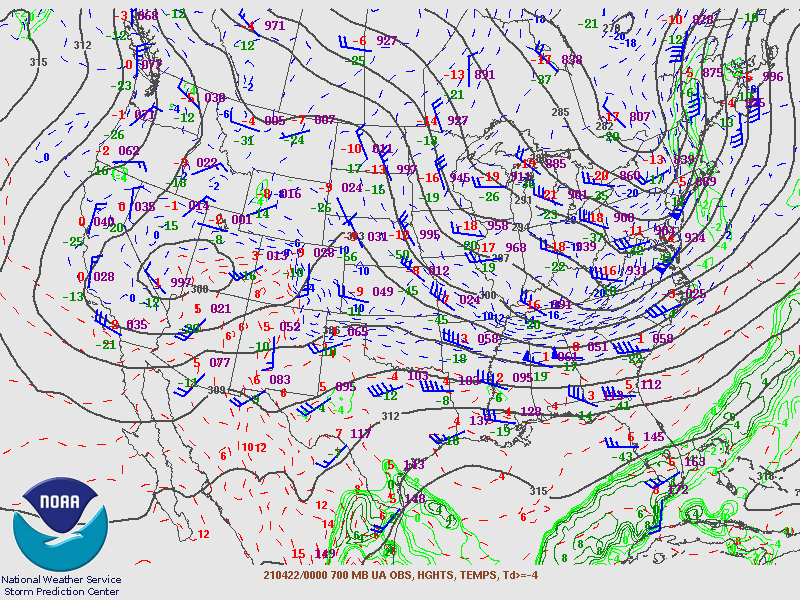
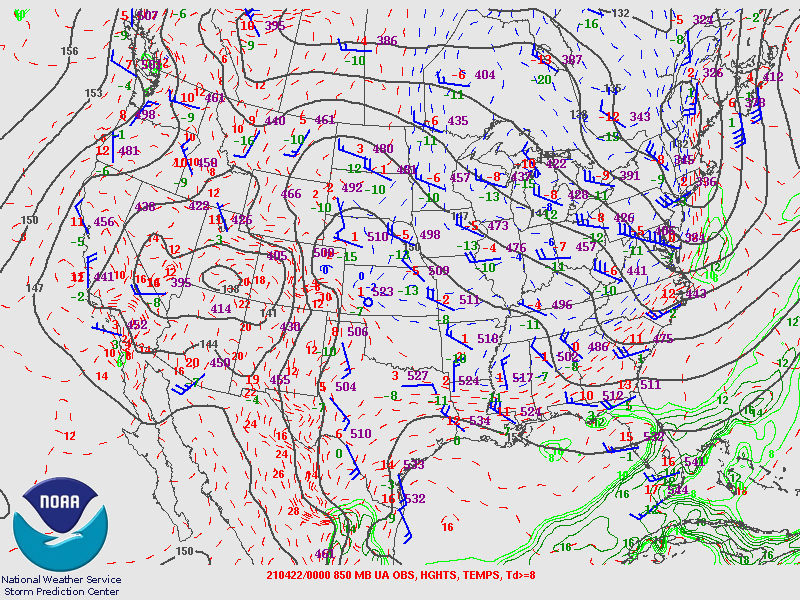
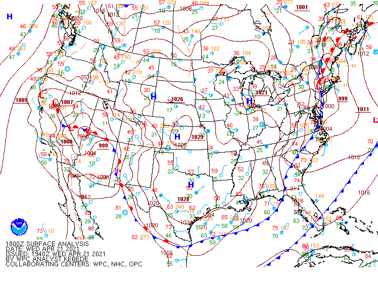
Synoptic Overview at 00z 22 April 2021 (courtesy of SPC)
 |
 |
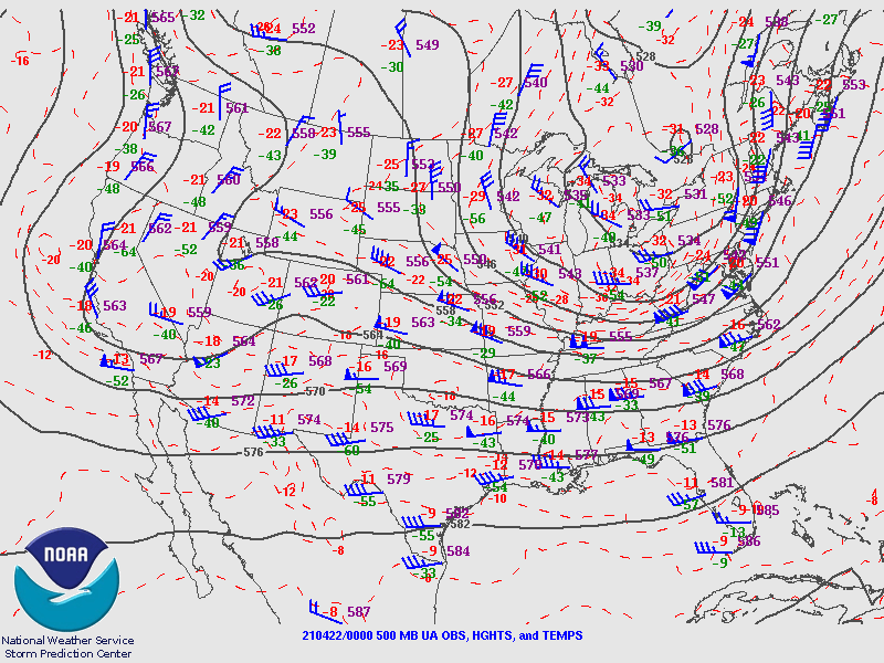 |
| Figure 7: 250-mb analysis | Figure 8: 300-mb analysis | Figure 9: 500-mb analysis |
 |
 |
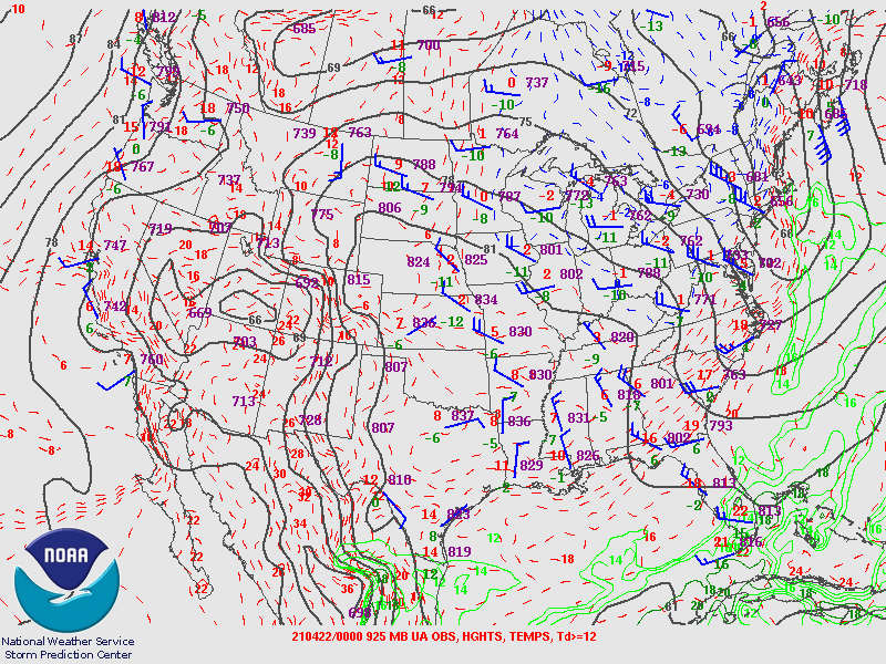 |
| Figure 10: 700-mb analysis | Figure 11: 850-mb analysis | Figure 12: 925-mb analysis |
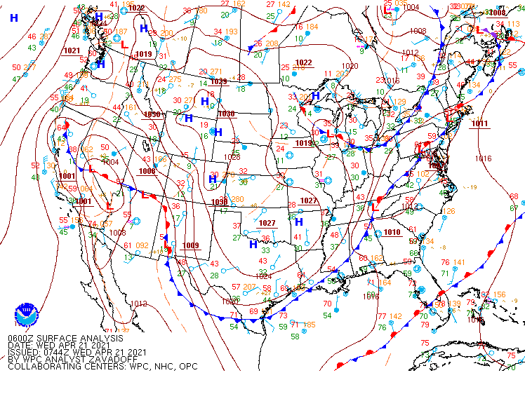
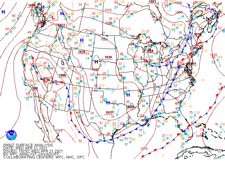
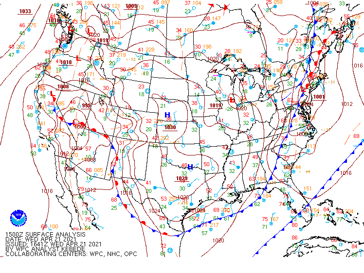
Surface Maps (courtesy of WPC)
 |
 |
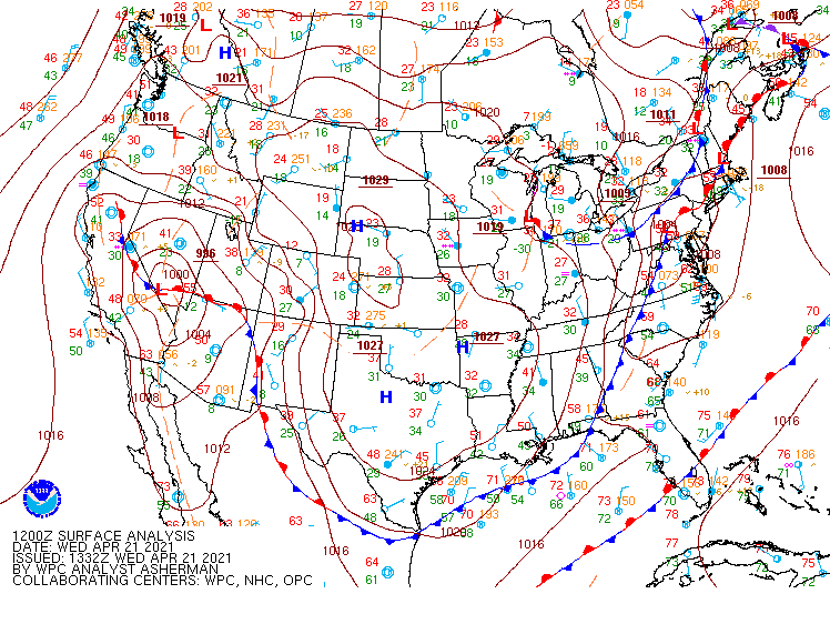 |
| Figure 13: 06z surface map | Figure 14: 09z surface map | Figure 15: 12z surface map |
 |
 |
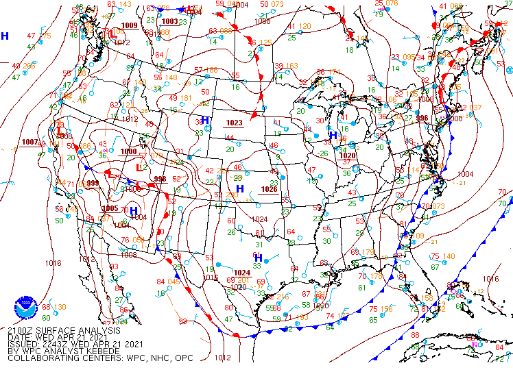 |
| Figure 16: 15z surface map | Figure 17: 18z surface map | Figure 18: 21z surface map |
 |
 |
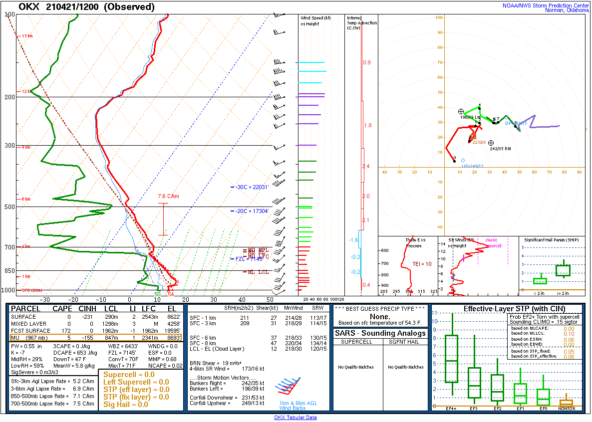 |
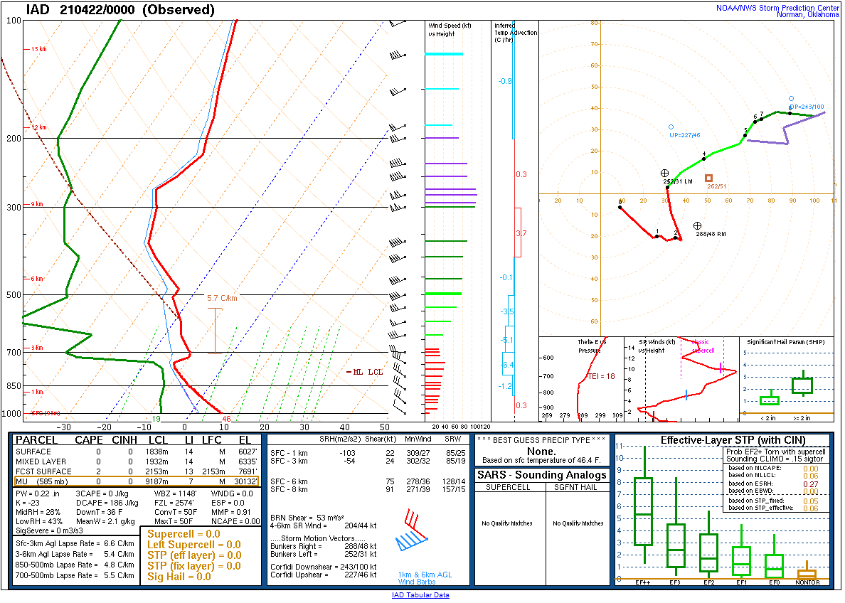
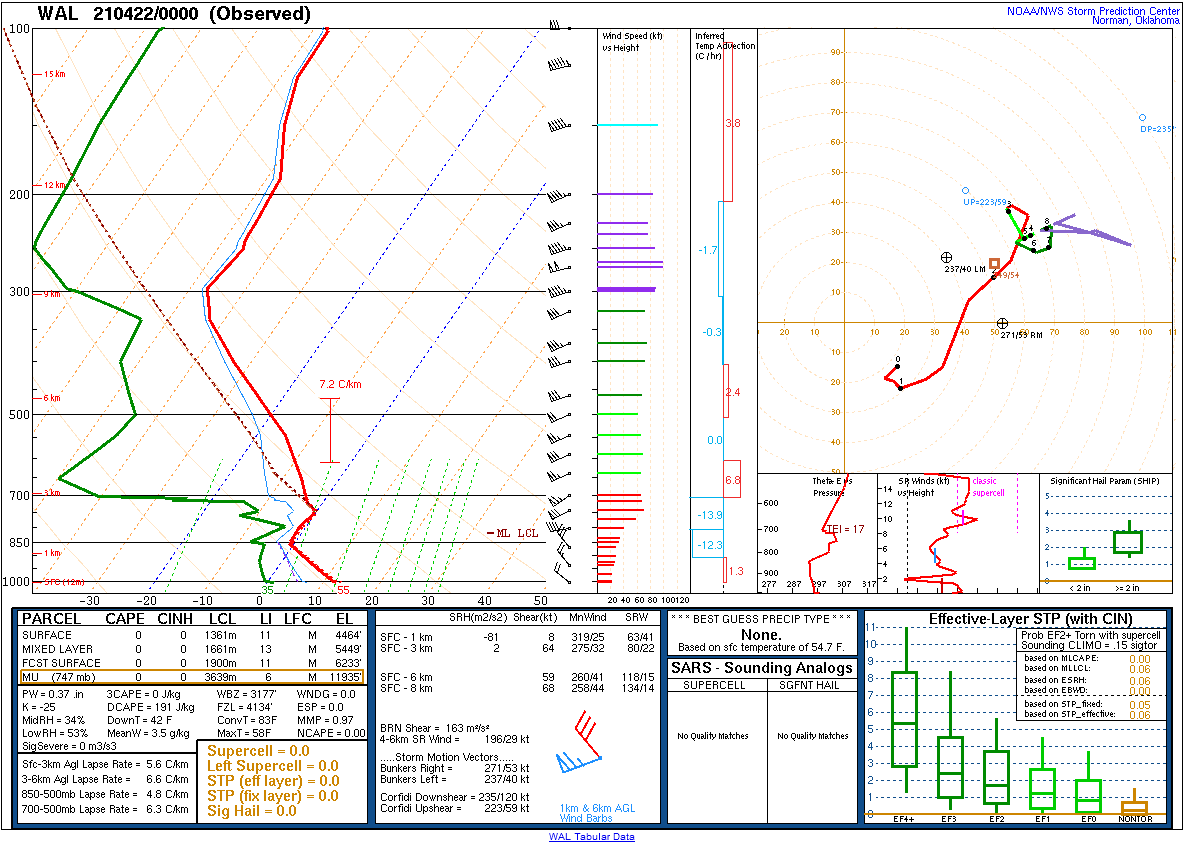
| Figure 19: 12z Sterling, VA sounding | Figure 20: 12z Wallops Island, VA sounding | Figure 21: 12z Long Island, NY sounding |
 |
 |
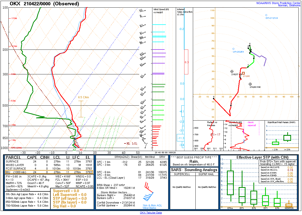 |
| Figure 22: 0z Sterling, VA sounding | Figure 23: 0z Wallops Island, VA sounding | Figure 24: 0z Long Island, NY sounding |
 |
 |
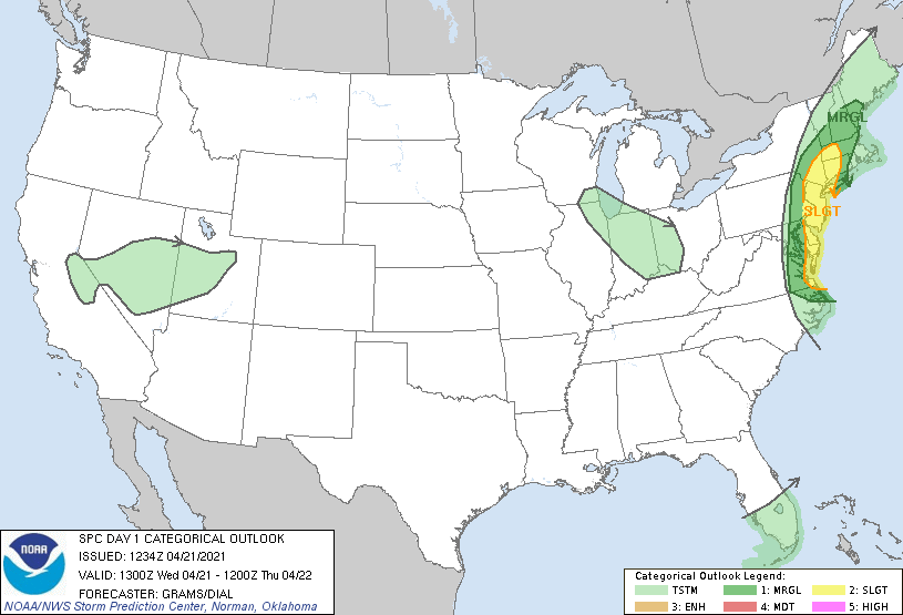 |
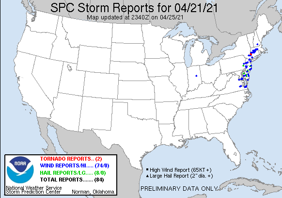
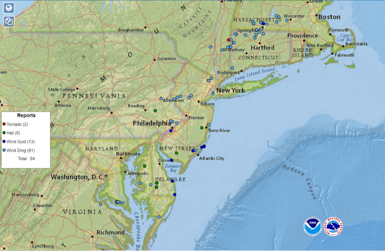
| Figure 1: National Preliminary Reports 12z 21 April 2021 to 12z 22 April 2021. | Figure 2: Zoomed Preliminary Reports for the same period. | Figure 3: April 21 1300z SPC Convective Outlook. |
Click here for a county warning area based plot of local storm reports and warnings/advisories issued for the 21 April 2021 event.
NWUS51 KPHI 220034
LSRPHI
PRELIMINARY LOCAL STORM REPORT...SUMMARY
NATIONAL WEATHER SERVICE MOUNT HOLLY NJ
834 PM EDT WED APR 21 2021
..TIME... ...EVENT... ...CITY LOCATION... ...LAT.LON...
..DATE... ....MAG.... ..COUNTY LOCATION..ST.. ...SOURCE....
..REMARKS..
1220 PM HAIL 2 SSW DISTRICT TWP 40.43N 75.66W
04/21/2021 E0.25 INCH BERKS PA TRAINED SPOTTER
1222 PM HAIL 1 S BOYERTOWN 40.32N 75.64W
04/21/2021 M1.00 INCH BERKS PA TRAINED SPOTTER
1227 PM HAIL 1 NE EASTLAWN GARDENS 40.76N 75.29W
04/21/2021 M0.25 INCH NORTHAMPTON PA TRAINED SPOTTER
1230 PM HAIL 3 WNW UWCHLAN TWP 40.07N 75.68W
04/21/2021 E0.25 INCH CHESTER PA TRAINED SPOTTER
1235 PM HAIL TATAMY 40.74N 75.25W
04/21/2021 M0.25 INCH NORTHAMPTON PA TRAINED SPOTTER
PEA SIZE HAIL REPORTED BY A TRAINED SPOTTER
IN TATAMY, PA. TIME ESTIMATED BY RADAR.
1235 PM HAIL EMMAUS 40.54N 75.49W
04/21/2021 M0.25 INCH LEHIGH PA TRAINED SPOTTER
1235 PM TSTM WND DMG 1 SSW ALLENTOWN 40.58N 75.48W
04/21/2021 LEHIGH PA UTILITY COMPANY
TREE DOWN ON WIRES NEAR LEHIGH PKWY. TIME
ESTIMATED FROM RADAR.
1240 PM HAIL 2 ENE BETHLEHEM TWP 40.67N 75.30W
04/21/2021 M0.50 INCH NORTHAMPTON PA TRAINED SPOTTER
1240 PM HAIL 1 WSW BETHLEHEM TWP 40.65N 75.36W
04/21/2021 E0.25 INCH NORTHAMPTON PA TRAINED SPOTTER
1245 PM HAIL MARTINS CREEK 40.78N 75.18W
04/21/2021 E0.25 INCH NORTHAMPTON PA TRAINED SPOTTER
1245 PM HAIL 2 WNW FORKS TWP 40.74N 75.21W
04/21/2021 E0.88 INCH NORTHAMPTON PA TRAINED SPOTTER
1248 PM HAIL TRUMBAUERSVILLE 40.41N 75.38W
04/21/2021 E0.25 INCH BUCKS PA TRAINED SPOTTER
1250 PM HAIL HARLEYSVILLE 40.28N 75.39W
04/21/2021 E0.25 INCH MONTGOMERY PA TRAINED SPOTTER
1250 PM HAIL MARTINS CREEK 40.78N 75.18W
04/21/2021 E0.25 INCH NORTHAMPTON PA TRAINED SPOTTER
1250 PM HAIL 2 WSW WILLIAMS TWP 40.63N 75.24W
04/21/2021 E0.25 INCH NORTHAMPTON PA TRAINED SPOTTER
1250 PM HAIL COLLEGEVILLE 40.19N 75.45W
04/21/2021 E0.25 INCH MONTGOMERY PA PUBLIC
1252 PM HAIL LANDENBERG 39.78N 75.76W
04/21/2021 E0.25 INCH CHESTER PA TRAINED SPOTTER
1255 PM HAIL KENNETT SQUARE 39.85N 75.70W
04/21/2021 E0.25 INCH CHESTER PA TRAINED SPOTTER
1258 PM HAIL KINTNERSVILLE 40.56N 75.17W
04/21/2021 E0.50 INCH BUCKS PA TRAINED SPOTTER
0100 PM TSTM WND GST WHITE CLAY CREEK 39.73N 75.73W
04/21/2021 M46 MPH NEW CASTLE DE MESONET
0100 PM HAIL 2 N CENTREVILLE 39.07N 76.07W
04/21/2021 E0.25 INCH QUEEN ANNES MD TRAINED SPOTTER
0100 PM HAIL 1 W EASTON 40.69N 75.22W
04/21/2021 E0.70 INCH NORTHAMPTON PA PUBLIC
DIME SIZE HAIL IN EASTON. TIME ESTIMATED
FROM RADAR.
0100 PM HAIL NEWARK 39.68N 75.76W
04/21/2021 E0.70 INCH NEW CASTLE DE PUBLIC
0103 PM HAIL COLLEGEVILLE 40.19N 75.46W
04/21/2021 E0.88 INCH MONTGOMERY PA TRAINED SPOTTER
0105 PM TSTM WND GST 1 ENE POHATCONG TWP 40.66N 75.12W
04/21/2021 M46 MPH WARREN NJ MESONET
0105 PM HAIL PIKE CREEK 39.73N 75.70W
04/21/2021 E0.25 INCH NEW CASTLE DE TRAINED SPOTTER
0105 PM TSTM WND DMG UPPER BLACK EDDY 40.57N 75.10W
04/21/2021 BUCKS PA PUBLIC
LARGE TREE DOWN.
0110 PM TSTM WND DMG 3 N ALEXANDRIA TWP 40.61N 75.02W
04/21/2021 HUNTERDON NJ UTILITY COMPANY
TREE DOWN ON WIRES ON RICK RD. TIME
ESTIMATED FROM RADAR.
0115 PM HAIL HOCKESSIN 39.79N 75.69W
04/21/2021 E0.50 INCH NEW CASTLE DE TRAINED SPOTTER
0115 PM HAIL 1 NE BROOKFIELD 39.86N 75.59W
04/21/2021 M0.25 INCH DELAWARE PA TRAINED SPOTTER
0115 PM HAIL 1 NW TALLEYVILLE 39.82N 75.57W
04/21/2021 E0.25 INCH NEW CASTLE DE TRAINED SPOTTER
0120 PM HAIL 3 SE CHURCH HILL 39.11N 75.95W
04/21/2021 E1.00 INCH QUEEN ANNES MD TRAINED SPOTTER
0120 PM TSTM WND DMG 1 WSW CLINTON 40.63N 74.92W
04/21/2021 HUNTERDON NJ DEPT OF HIGHWAYS
DOWNED TREE ON I-78 EASTBOUND RAMP TO EXIT
15. ONE LANE WAS CLOSED. TIME ESTIMATED FROM
RADAR.
0122 PM HAIL SICKLERVILLE 39.72N 74.97W
04/21/2021 E0.25 INCH CAMDEN NJ TRAINED SPOTTER
0123 PM HAIL WASHINGTON TWP 39.75N 75.07W
04/21/2021 M0.25 INCH GLOUCESTER NJ TRAINED SPOTTER
PEA SIZE HAIL REPORTED IN WASHINGTON
TOWNSHIP.
0125 PM HAIL 3 NW MILLVILLE 39.43N 75.07W
04/21/2021 E0.25 INCH CUMBERLAND NJ TRAINED SPOTTER
0135 PM HAIL SPRINGFIELD 39.93N 75.32W
04/21/2021 E0.25 INCH DELAWARE PA TRAINED SPOTTER
0135 PM TSTM WND DMG 3 S EASTON 38.74N 76.07W
04/21/2021 TALBOT MD DEPT OF HIGHWAYS
US-50 WESTBOUND WAS CLOSED BETWEEN
SCHWANINGER RD AND LANDING NECK RD DUE TO
DOWN POWER LINES. TIME ESTIMATED FROM RADAR.
0136 PM TSTM WND GST PHILADELPHIA INTERNATIO 39.88N 75.23W
04/21/2021 M52 MPH PHILADELPHIA PA ASOS
ASOS STATION KPHL PHILADELPHIA INTERNATIONAL
AIRPORT.
0140 PM TSTM WND DMG 1 SSW WYNCOTE 40.08N 75.15W
04/21/2021 MONTGOMERY PA UTILITY COMPANY
TREE LIMBS DOWN ON WIRES ON ROCK CREEK DR.
TIME ESTIMATED FROM RADAR.
0140 PM TSTM WND GST 1 SSE SOUTH PHILADELPHI 39.89N 75.20W
04/21/2021 M59 MPH PHILADELPHIA PA MESONET
PENNDOT RWIS STATION AT I-95 AND GIRARD
AVENUE.
0140 PM HAIL CHESTER 40.79N 74.69W
04/21/2021 E0.25 INCH MORRIS NJ TRAINED SPOTTER
0140 PM HAIL SPARTA 41.04N 74.63W
04/21/2021 E0.25 INCH SUSSEX NJ TRAINED SPOTTER
0145 PM TSTM WND DMG 1 SE FLOURTOWN 40.10N 75.20W
04/21/2021 MONTGOMERY PA UTILITY COMPANY
TREE DOWN ON WIRES ON TYSON RD. TIME
ESTIMATED FROM RADAR.
0145 PM HAIL 1 WSW DOVER 39.16N 75.54W
04/21/2021 E0.25 INCH KENT DE PUBLIC
SOCIAL MEDIA.
0148 PM HAIL MEDFORD 39.89N 74.82W
04/21/2021 E0.88 INCH BURLINGTON NJ PUBLIC
MOSTLY PEA-SIZED WITH A FEW PENNY TO
NICKEL-SIZED STONES. REPORT VIA SOCIAL
MEDIA.
0148 PM HAIL 1 SE POINT BREEZE 39.92N 75.17W
04/21/2021 E0.25 INCH PHILADELPHIA PA TRAINED SPOTTER
0148 PM TSTM WND DMG 3 N BRANCHBURG TWP 40.60N 74.69W
04/21/2021 SOMERSET NJ DEPT OF HIGHWAYS
UTILITY POLE DOWN ON US-22 EASTBOUND WEST OF
READINGTON RD. ALL LANES WERE CLOSED. TIME
ESTIMATED FROM RADAR.
0150 PM HAIL 2 NW EDGE HILL 39.19N 75.55W
04/21/2021 E0.70 INCH KENT DE PUBLIC
DIME SIZE HAIL IN DOVER, DE. TIME ESTIMATED
FROM RADAR.
0155 PM TSTM WND DMG 3 SSE FAR HILLS 40.65N 74.62W
04/21/2021 SOMERSET NJ PUBLIC
A FEW MEDIUM SIZED TREE BRANCHES DOWN. TIME
ESTIMATED FROM RADAR.
0155 PM HAIL MORRIS TWP 40.78N 74.46W
04/21/2021 E0.25 INCH MORRIS NJ TRAINED SPOTTER
0156 PM HAIL 1 ESE WHIPPANY 40.83N 74.40W
04/21/2021 E0.25 INCH MORRIS NJ TRAINED SPOTTER
PEA SIZE HAIL REPORTED IN WHIPPANY, NJ. TIME
ESTIMATED FROM RADAR.
0158 PM TSTM WND DMG 1 N HOLMESBURG 40.06N 75.03W
04/21/2021 PHILADELPHIA PA UTILITY COMPANY
POWER OUTAGE DUE TO SEVERE WEATHER NEAR
HOLME CIRCLE. TIME ESTIMATED FROM RADAR.
0200 PM TSTM WND DMG FEDERALSBURG 38.70N 75.78W
04/21/2021 CAROLINE MD BROADCAST MEDIA
TREE DOWN ON VEHICLE.
0200 PM HAIL 2 WNW NEPTUNE CITY 40.21N 74.06W
04/21/2021 E0.25 INCH MONMOUTH NJ TRAINED SPOTTER
0200 PM HAIL 1 ENE LAWRENCEVILLE 40.30N 74.71W
04/21/2021 E0.70 INCH MERCER NJ EMERGENCY MNGR
0210 PM TSTM WND GST FORTESCUE 39.24N 75.18W
04/21/2021 M58 MPH CUMBERLAND NJ MESONET
FORTESCUE NJ WEATHERNET SITE.
0210 PM MARINE TSTM WIND FORTESCUE 39.24N 75.18W
04/21/2021 M58 MPH ANZ430 NJ MESONET
FORTESCUE NJ WEATHERNET SITE.
0212 PM HAIL BRIDGEVILLE 38.74N 75.60W
04/21/2021 M1.00 INCH SUSSEX DE BROADCAST MEDIA
TIME ESTIMATED FROM RADAR.
0212 PM HAIL SEAFORD 38.64N 75.61W
04/21/2021 M1.00 INCH SUSSEX DE BROADCAST MEDIA
TIME ESTIMATED FROM RADAR.
0214 PM HAIL BRIDGEVILLE 38.74N 75.61W
04/21/2021 E1.00 INCH SUSSEX DE BROADCAST MEDIA
0214 PM HAIL SEAFORD 38.65N 75.61W
04/21/2021 E1.00 INCH SUSSEX DE BROADCAST MEDIA
0220 PM HAIL 2 N GEORGETOWN 38.71N 75.39W
04/21/2021 E0.25 INCH SUSSEX DE TRAINED SPOTTER
0220 PM TSTM WND GST 1 W MILLVILLE MUNICIPAL 39.37N 75.08W
04/21/2021 M54 MPH CUMBERLAND NJ ASOS
ASOS STATION KMIV MILLVILLE.
0222 PM HAIL 2 NW BERKELEY TWP 39.95N 74.32W
04/21/2021 E1.00 INCH OCEAN NJ PUBLIC
AN MPING REPORT OF QUARTER SIZE HAIL. TIME
ESTIMATED FROM RADAR.
0223 PM HAIL MILLVILLE 39.40N 75.04W
04/21/2021 E1.00 INCH CUMBERLAND NJ PUBLIC
0224 PM HAIL 1 WSW MILLVILLE 39.40N 75.05W
04/21/2021 E0.88 INCH CUMBERLAND NJ PUBLIC
SOCIAL MEDIA. TIME ESTIMATED FROM RADAR.
0225 PM HAIL 2 WSW LAKEHURST 40.00N 74.34W
04/21/2021 E0.25 INCH OCEAN NJ PUBLIC
SOCIAL MEDIA.
0225 PM HAIL HELMETTA 40.38N 74.41W
04/21/2021 E0.25 INCH MIDDLESEX NJ TRAINED SPOTTER
0225 PM TSTM WND GST MILTON 38.78N 75.32W
04/21/2021 M44 MPH SUSSEX DE TRAINED SPOTTER
0235 PM MARINE TSTM WIND 1 WNW LEWES 38.78N 75.16W
04/21/2021 M58 MPH SUSSEX DE MESONET
0235 PM HAIL 2 NW WALL TWP 40.17N 74.09W
04/21/2021 E0.25 INCH MONMOUTH NJ PUBLIC
0235 PM TSTM WND GST 1 WNW LEWES 38.78N 75.16W
04/21/2021 M58 MPH SUSSEX DE MESONET
0238 PM MARINE TSTM WIND INDIAN BEACH 38.68N 75.08W
04/21/2021 M56 MPH SUSSEX DE MESONET
MESONET STATION XDEW DEWEY BEACH GUSTED TO
56 MPH.
0240 PM HAIL SEASIDE HEIGHTS 39.94N 74.07W
04/21/2021 M0.25 INCH OCEAN NJ TRAINED SPOTTER
0240 PM HAIL DOROTHY 39.41N 74.81W
04/21/2021 M0.25 INCH ATLANTIC NJ TRAINED SPOTTER
0241 PM TSTM WND DMG 2 SE LEISURE VILLAGE EA 40.01N 74.13W
04/21/2021 OCEAN NJ PUBLIC
GARDEN SHED BLOWN OVER, SECTION OF VINYL
FENCE BROUGHT DOWN, AND SHINGLES BLOWN OFF
HOUSE. TIME ESTIMATED FROM RADAR. SOCIAL
MEDIA.
0243 PM HAIL 1 ESE MANAHAWKIN 39.69N 74.24W
04/21/2021 E0.25 INCH OCEAN NJ PUBLIC
0244 PM HAIL 1 N SEASIDE HEIGHTS 39.96N 74.07W
04/21/2021 E0.25 INCH OCEAN NJ PUBLIC
0245 PM TSTM WND GST CAPE MAY 38.94N 74.92W
04/21/2021 M46 MPH CAPE MAY NJ MESONET
0245 PM MARINE TSTM WIND CAPE MAY 38.93N 74.92W
04/21/2021 M46 MPH CAPE MAY NJ MESONET
0245 PM HAIL BARNEGAT 39.75N 74.22W
04/21/2021 E0.25 INCH OCEAN NJ PUBLIC
0250 PM HAIL NORTHFIELD 39.37N 74.55W
04/21/2021 E0.25 INCH ATLANTIC NJ PUBLIC
SOCIAL MEDIA.
0250 PM TSTM WND GST DEWEY BEACH 38.69N 75.08W
04/21/2021 M48 MPH SUSSEX DE MESONET
0250 PM MARINE TSTM WIND DEWEY BEACH 38.69N 75.08W
04/21/2021 M48 MPH SUSSEX DE MESONET
0254 PM TSTM WND GST ATLANTIC CITY INTERNATI 39.45N 74.57W
04/21/2021 M63 MPH ATLANTIC NJ ASOS
ASOS STATION KACY ATLANTIC CITY GUSTED TO 63
MPH.
0255 PM MARINE TSTM WIND 1 NW SEA ISLE CITY 39.17N 74.71W
04/21/2021 M44 MPH CAPE MAY NJ MESONET
LUDLUM BAY.
0255 PM TSTM WND GST 1 NW SEA ISLE CITY 39.17N 74.71W
04/21/2021 M44 MPH CAPE MAY NJ MESONET
LUDLUM BAY.
0259 PM TSTM WND GST 3 NW FENWICK ISLAND 38.48N 75.09W
04/21/2021 M60 MPH SUSSEX DE PUBLIC
PERSONAL WEATHER STATION KDESELBY13.
0300 PM TSTM WND DMG 1 S GALLOWAY TWP 39.46N 74.51W
04/21/2021 ATLANTIC NJ BROADCAST MEDIA
TREES DOWN AT 6TH AVE AND RIDGEWOOD ST.
EMERGENCY MANAGEMENT REPORT RELAYED BY
BROADCAST MEDIA. TIME ESTIMATED FROM RADAR.
0300 PM MARINE TSTM WIND NORTH WILDWOOD 39.00N 74.79W
04/21/2021 M48 MPH CAPE MAY NJ MESONET
0300 PM MARINE TSTM WIND 3 SSE LANOKA HARBOR 39.82N 74.13W
04/21/2021 M41 MPH ANZ451 NJ MESONET
KITE ISLAND.
0305 PM MARINE TSTM WIND 1 W OCEAN CITY 39.28N 74.60W
04/21/2021 M45 MPH CAPE MAY NJ MESONET
POINT POINT.
0310 PM TSTM WND GST 1 SW BEACH HAVEN 39.55N 74.26W
04/21/2021 M61 MPH OCEAN NJ PUBLIC
PERSONAL WEATHER STATION KNJLONGB89.
0312 PM MARINE TSTM WIND 5 SE MYSTIC ISLAND 39.52N 74.32W
04/21/2021 M62 MPH OCEAN NJ MESONET
RUTGERS/ TUCKERTON MESONET GUST TO 62 MPH.
0315 PM HAIL LITTLE EGG HARBOR TWP 39.58N 74.36W
04/21/2021 M0.25 INCH OCEAN NJ TRAINED SPOTTER
0316 PM TSTM WND GST 2 SW BEACH HAVEN 39.54N 74.26W
04/21/2021 M62 MPH OCEAN NJ MESONET
CWOP SITE EW4321.
&&
$$
Notable Radar Imagery (GR2Analyst)
 |
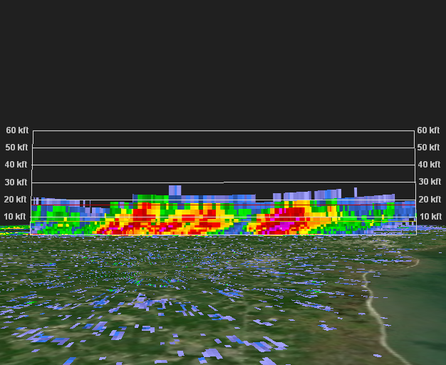 |
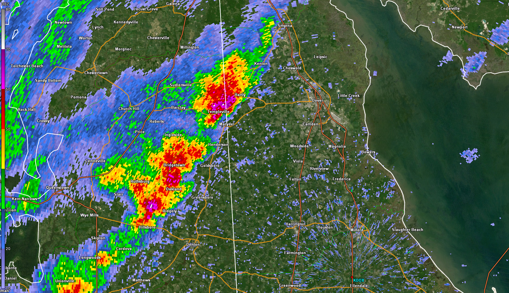
| Figure 1: KDOX radar reflectivity factor for the 0.5 degree elevation angle valid 1726 UTC 21 April 2021. A broken line of severe thunderstorms is visible over eastern Maryland and entering into Delaware. Sporadic reports of penny to quarter size hail were received from these cells. Steep lapse rates (a rapid decrease in temperature with height) caused many storms on April 21 to contain at least small hail, with a few containing severe hail of one inch or greater in diameter, or the size of a quarter. | Figure 2: KDOX radar reflectivity cross section taken along the line of storm cells seen in Figure 1. Multiple distinct, tilted updrafts are seen. Storm tops reached only 20,000 to 25,000 feet, quite shallow for severe convection and especially for convection producing severe hail. But this is not uncommon in early season severe weather, and the cool temperatures aloft helped compensate for the relatively shallow convection. |
 |
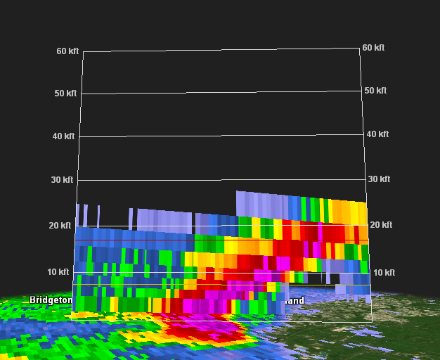 |
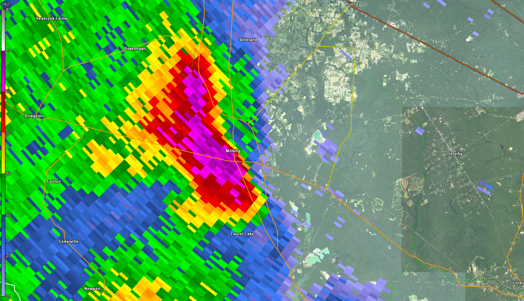
| Figure 3: KDIX radar reflectivity factor for the 0.5 degree elevation angle valid 1824 UTC 21 April 2021. A semi-discrete cell is seen passing directly over Millville, New Jersey. A wind gust of 54 mph was measured at the Millville Municipal Airport as this storm passed, and quarter size hail was reported in and around Millville. This storm had previously crossed Delaware Bay and produced a 58 mph wind gust in Fortescue, New Jersey. | Figure 4: KDIX radar reflectivity cross section for the storm shown in Figure 3. This time, the cross section is taken across (from west to east) as opposed to along (from southwest to northeast) the storm(s), but it shows a similar picture. A strong, tilted updraft is seen, with the tilt evidence of strong wind shear. Reflectivity values of 60dBz (demarcated by the pink pixels) extend up to 20,000 feet in elevation, and this was likely the most robust storm of the day. |
 |
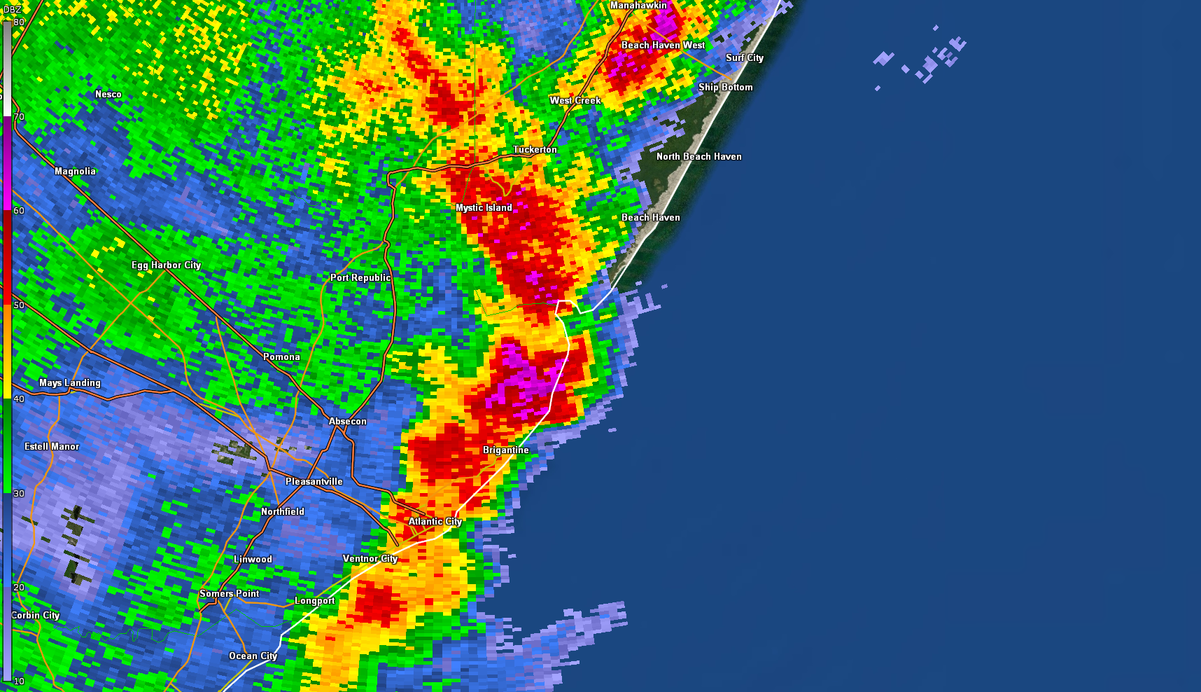 |
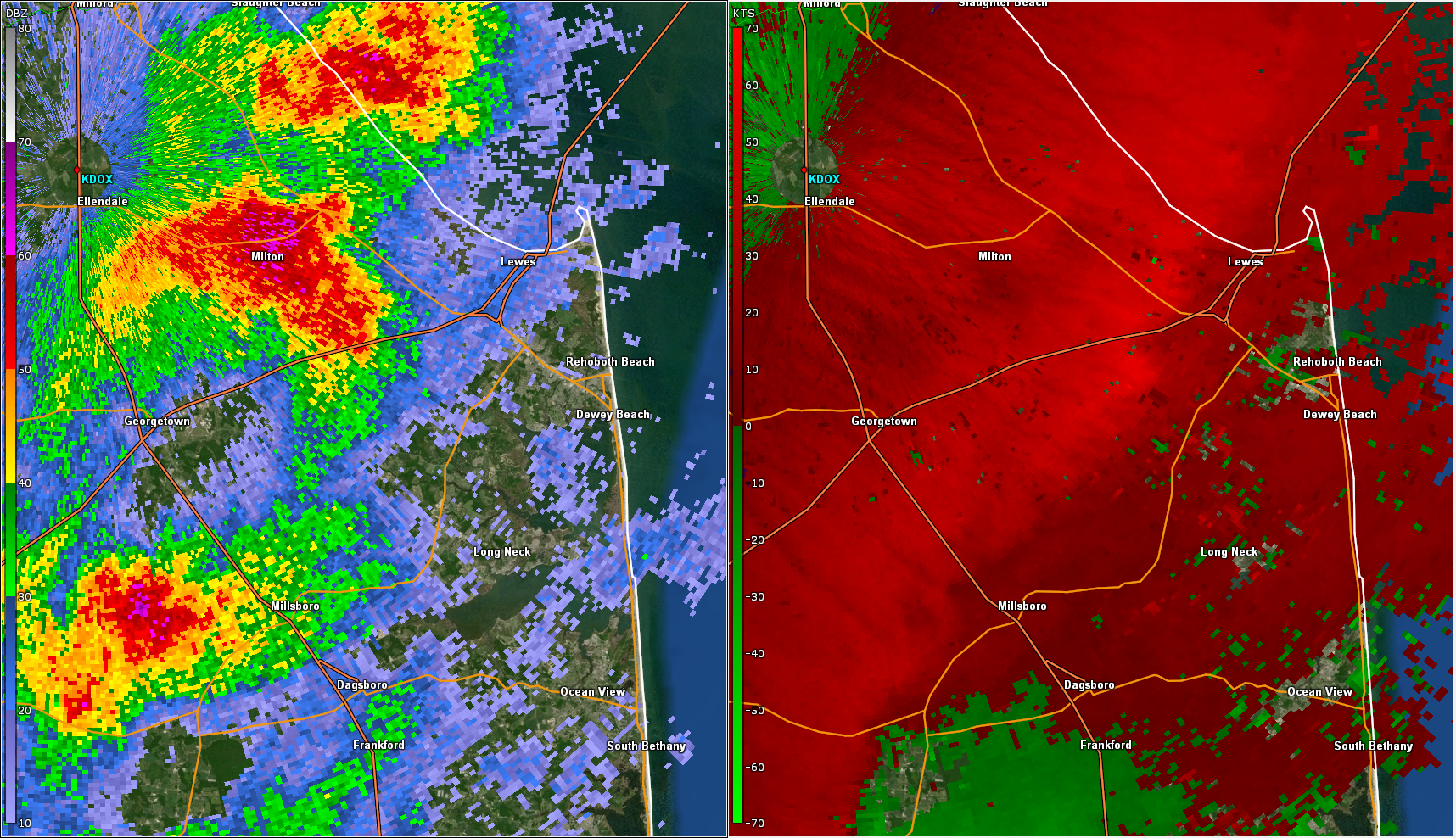
| Figure 5: KDOX radar reflectivity factor (left) and base velocity (right) for the 0.5 degree elevation angle valid 1828 UTC 21 April 2021. In addition to hail, a number of instances of damaging winds were observed on April 21. Storms in southern Delaware intensified as they approached the coast. Base velocity values of nearly 60 kt (69 mph) are seen at less than 1000 feet above ground level. Multiple instances of tree and utility damage and several measured gusts of 55 to 65 mph were recorded in southern and southeastern Delaware. | Figure 6: Same as Figure 3 valid at 1911 UTC 21 April 2021. Like the storms in southern Delaware, storms over southern New Jersey also intensified near the coast. This line of cells began to take on a bowing appearance as it moved offshore, a signature which is often accompanied by strong to severe wind. Multiple wind gusts over 60 mph were measured in Atlantic and southeastern Ocean Counties, with tree and utility damage also reported. |
US Dept of Commerce
National Oceanic and Atmospheric Administration
National Weather Service
Philadelphia/Mt Holly
732 Woodlane Rd.
Mount Holly, NJ 08060
609-261-6600
Comments? Questions? Please Contact Us.
Thank you for visiting a National Oceanic and Atmospheric Administration (NOAA) website. The link you have selected will take you to a non-U.S. Government website for additional information.
NOAA is not responsible for the content of any linked website not operated by NOAA. This link is provided solely for your information and convenience, and does not imply any endorsement by NOAA or the U.S. Department of Commerce of the linked website or any information, products, or services contained therein.
You will be redirected to:


 Coastal Flood
 Marine Forecasts
 Text Products
 Climate Information
 Skywarn
 Submit Storm Report
 Weather Event Archives
 Forecast Discussion
 Emergency Managers
 Briefing Page