
Severe thunderstorms may produce damaging winds, large hail, and numerous instances of flash/urban flooding over parts of the central Plains and lower Missouri Valley. Hazardous heat will continue in the South, Desert Southwest and the California Central Valley this weekend. Isolated dry thunderstorms may increase the risk of fire starts and spread across the Four Corners region and vicinity. Read More >
Overview
|
A series of several cold fronts, all producing little to no precipitation, moved through the mid-Atlantic in short succession from March 12-14, 2021. As the fronts moved through, they continually reinforced a westerly to northwesterly wind regime, with temperatures oscillating up and down ahead of and behind the rapid procession of fronts and periods of windy conditions. The prolonged west-northwest flow and constant intrusion of subsequently drier air masses with little to no precipitation in between led to several days of low humidity conditions. In addition, following several winter weather events and widespread snow pack during early to mid-February, largely drier than normal conditions had prevailed across the mid-Atlantic during later February and early March. While by no means exceptionally dry, this background state combined with the meteorological conditions caused a notable fire weather event to occur across parts of the mid-Atlantic in mid-March, lasting from March 13-15, peaking on the 14th. During that time, much of the region reached Red Flag Warning criteria for an extended period, including a particularly anomalous period of windy and dry conditions during the overnight hours of March 14. A number of brush fires were reported across the area during this event. The highest profile of these was a wildfire in the area of Lakewood, NJ, which burned around 170 acres and proved difficult for firefighters to contain, requiring a coordinated multi-agency containment effort. By late March 15 and beyond, decreasing winds and rising humidity brought an end to the fire weather threat. Additional details on the meteorology of this case and brief background on fire weather forecasting are provided in the analysis tab. |
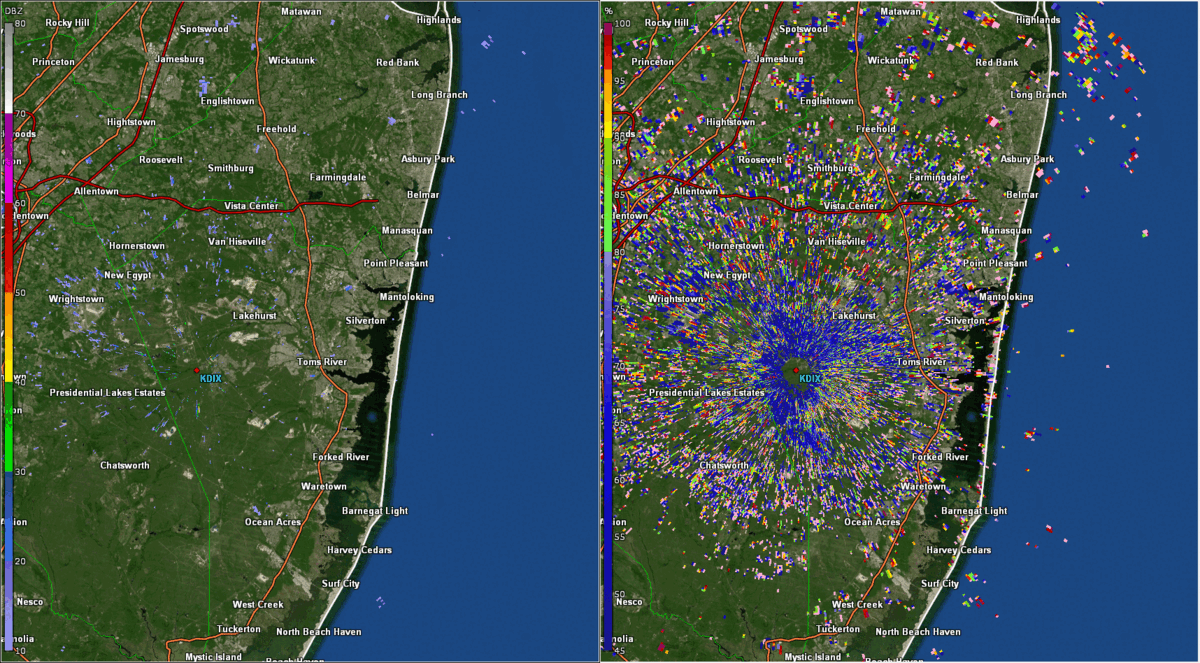 KDIX radar imagery from about 1:30 to 3:30 PM EDT March 14, 2021. Radar echoes associated with a wildfire near Lakewood, NJ can be seen in both reflectivity (left) and correlation coefficient (CC, right) data. The very low CC values confirm that the radar is detecting smoke, as opposed to any kind of meteorological target. |
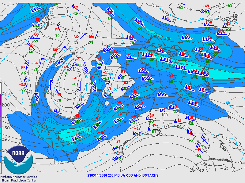
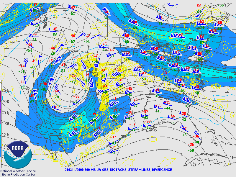
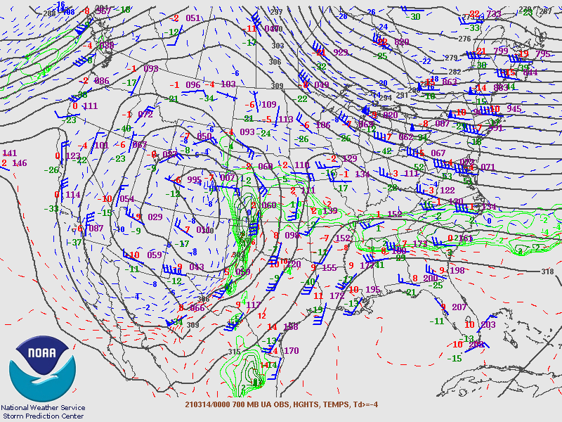
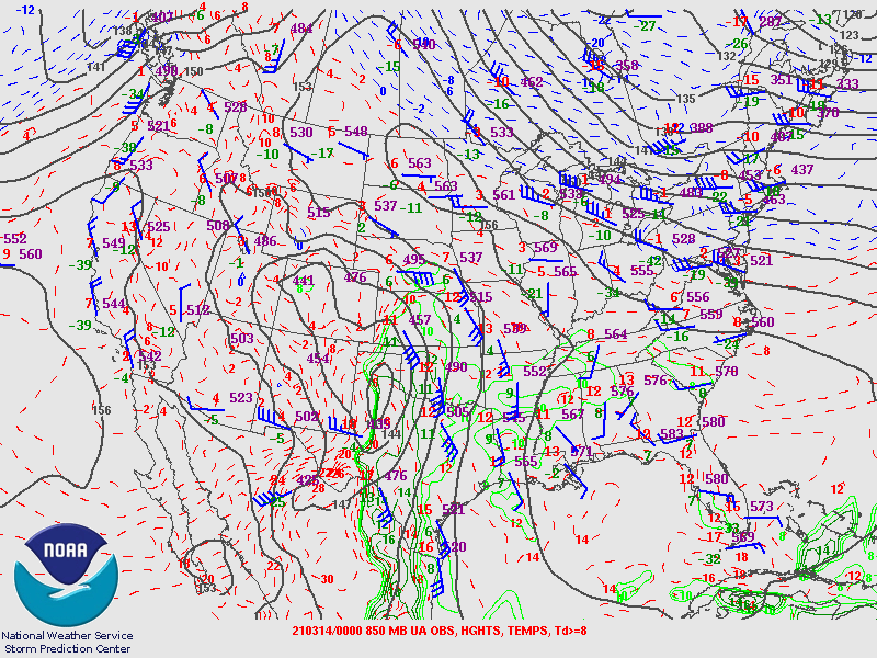
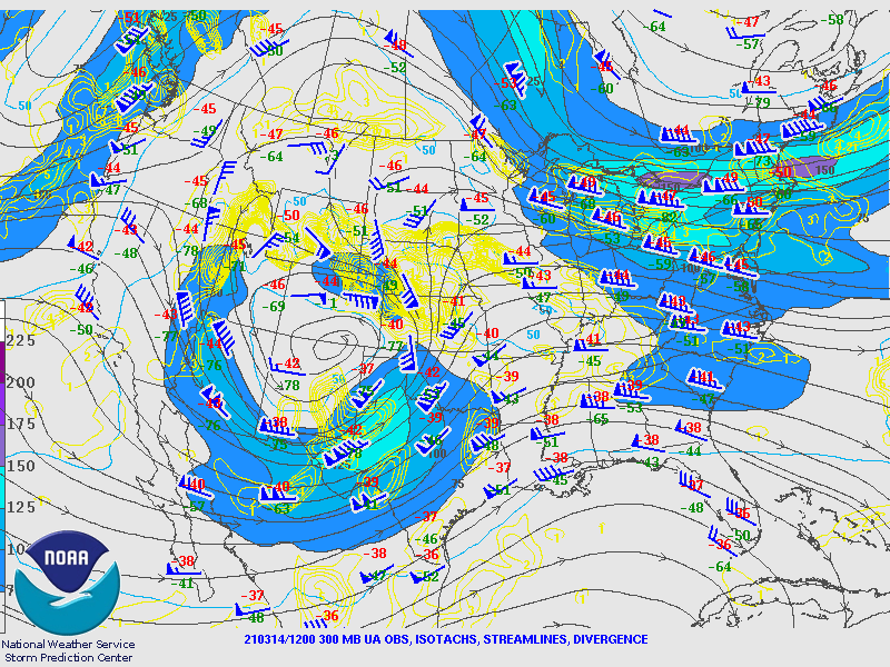
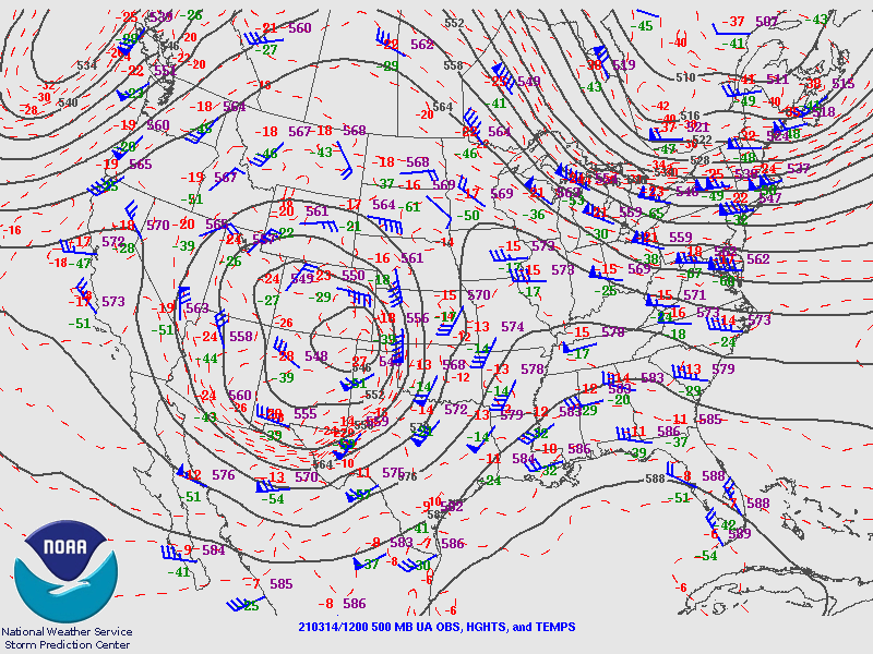
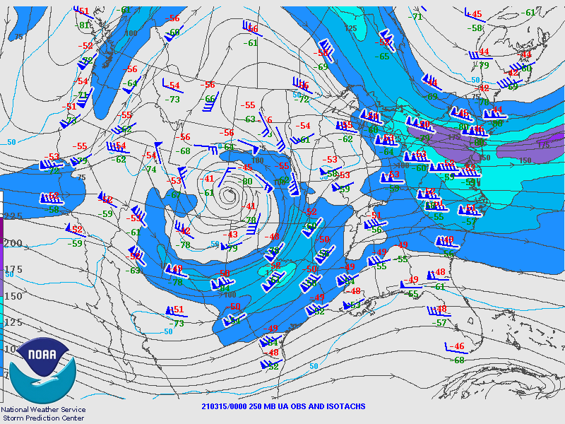
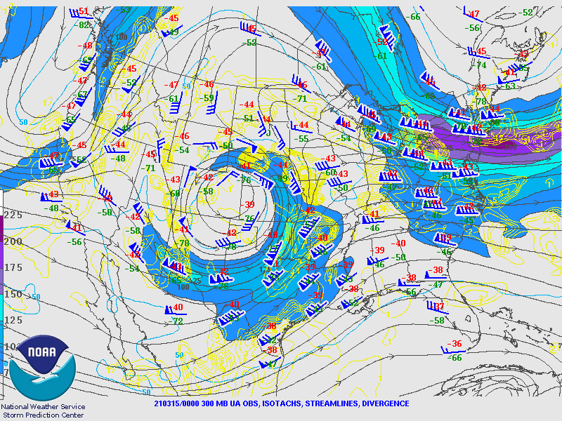
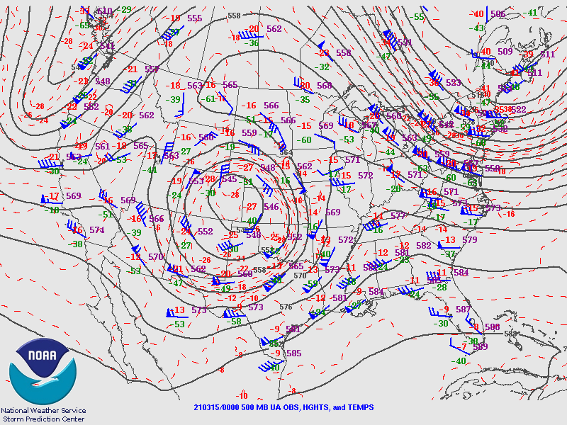
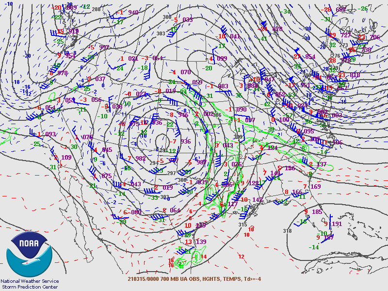
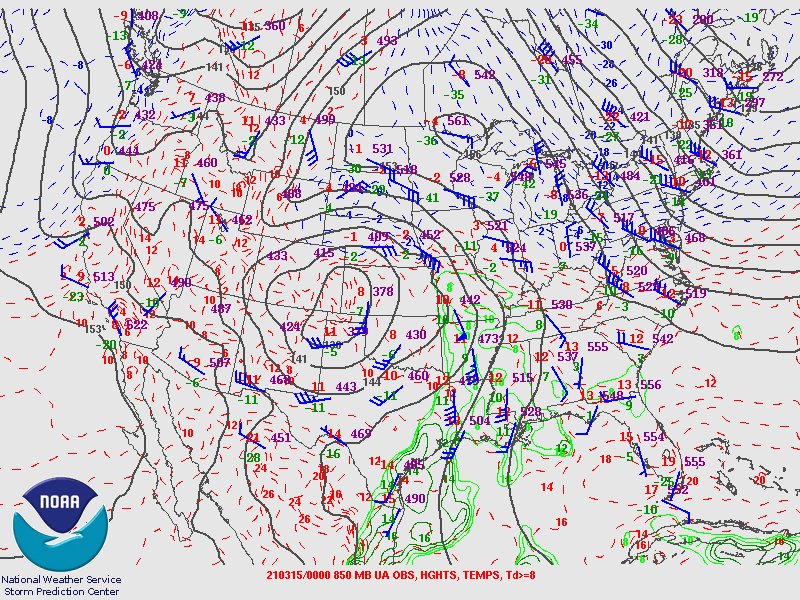
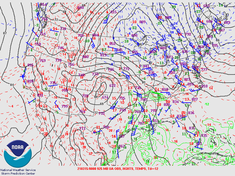
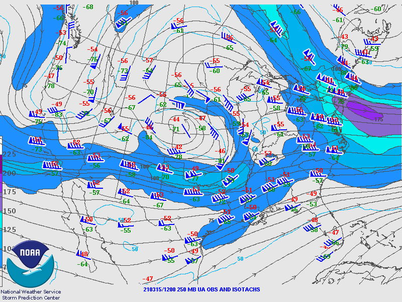
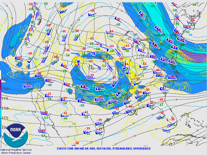
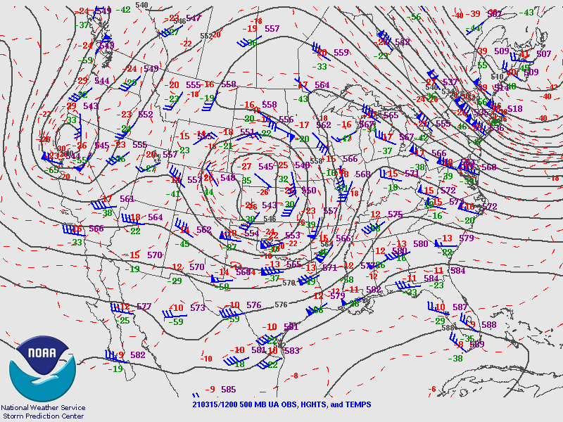
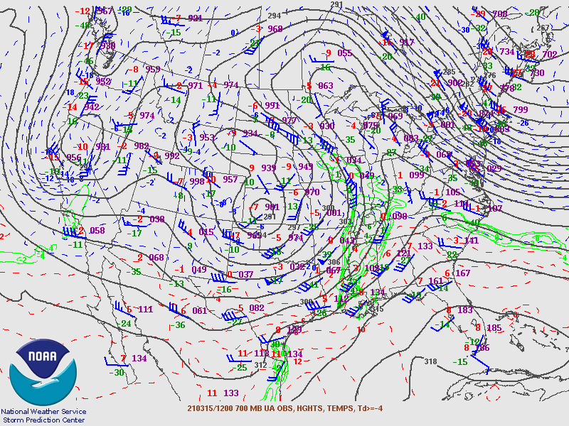
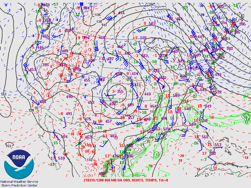
Synoptic Overview at 00z 14 Mar 2021 (courtesy of SPC)
 |
 |
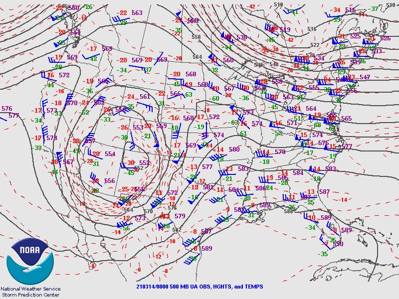 |
| Figure 1: 250-mb analysis | Figure 2: 300-mb analysis | Figure 3: 500-mb analysis |
 |
 |
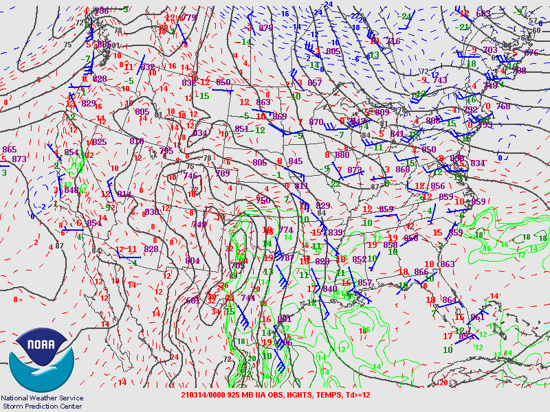 |
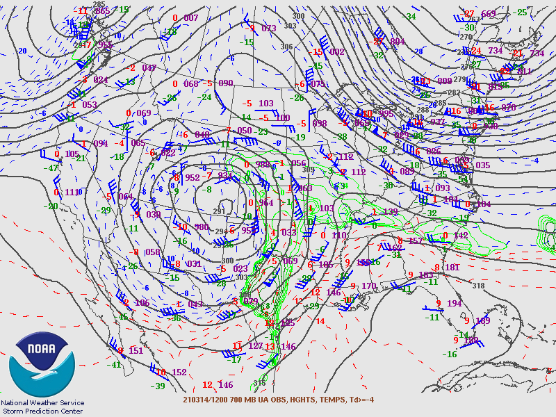
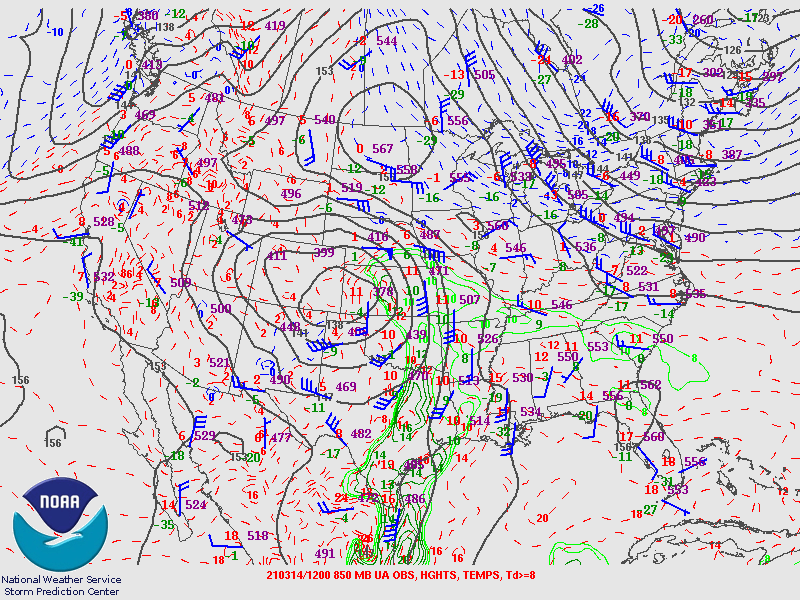
| Figure 4: 700-mb analysis | Figure 5: 850-mb analysis | Figure 6: 925-mb analysis |
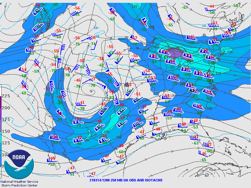
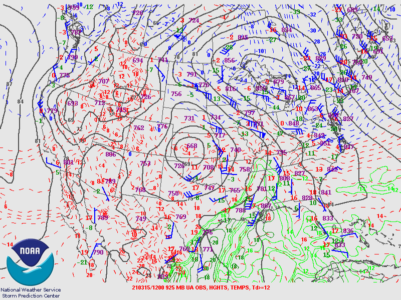
Synoptic Overview at 12z 14 Mar 2021 (courtesy of SPC)
 |
 |
 |
| Figure 7: 250-mb analysis | Figure 8: 300-mb analysis | Figure 9: 500-mb analysis |
 |
 |
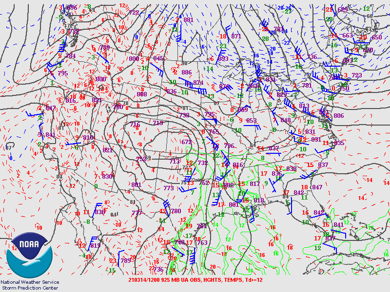 |
| Figure 10: 700-mb analysis | Figure 11: 850-mb analysis | Figure 12: 925-mb analysis |
Synoptic Overview at 00z 15 Mar 2021 (courtesy of SPC)
 |
 |
 |
| Figure 13: 250-mb analysis | Figure 14: 300-mb analysis | Figure 15: 500-mb analysis |
 |
 |
 |
| Figure 16: 700-mb analysis | Figure 17: 850-mb analysis | Figure 18: 925-mb analysis |
Synoptic Overview at 12z 15 Mar 2021 (courtesy of SPC)
 |
 |
 |
| Figure 19: 250-mb analysis | Figure 20: 300-mb analysis | Figure 21: 500-mb analysis |
 |
 |
 |
| Figure 22: 700-mb analysis | Figure 23: 850-mb analysis | Figure 24: 925-mb analysis |
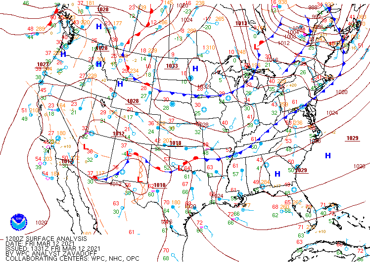 |
| Figure 25: WPC Surface Analysis at 6 hour increments from 12z March 12 - 12z March 15, 2021. The procession of several cold fronts through the mid-Atlantic is seen. |
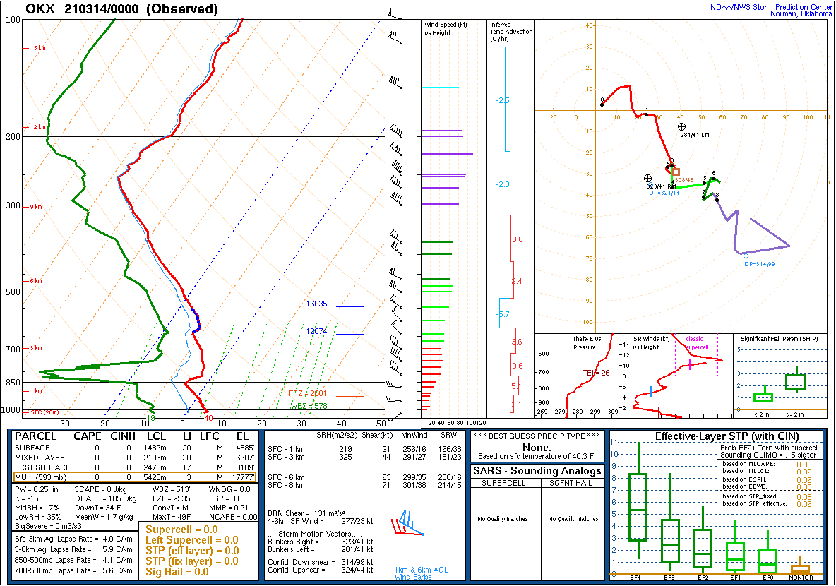
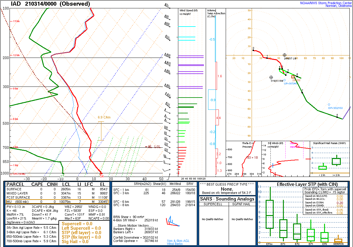
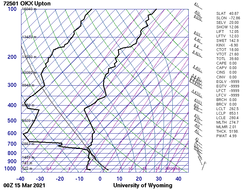
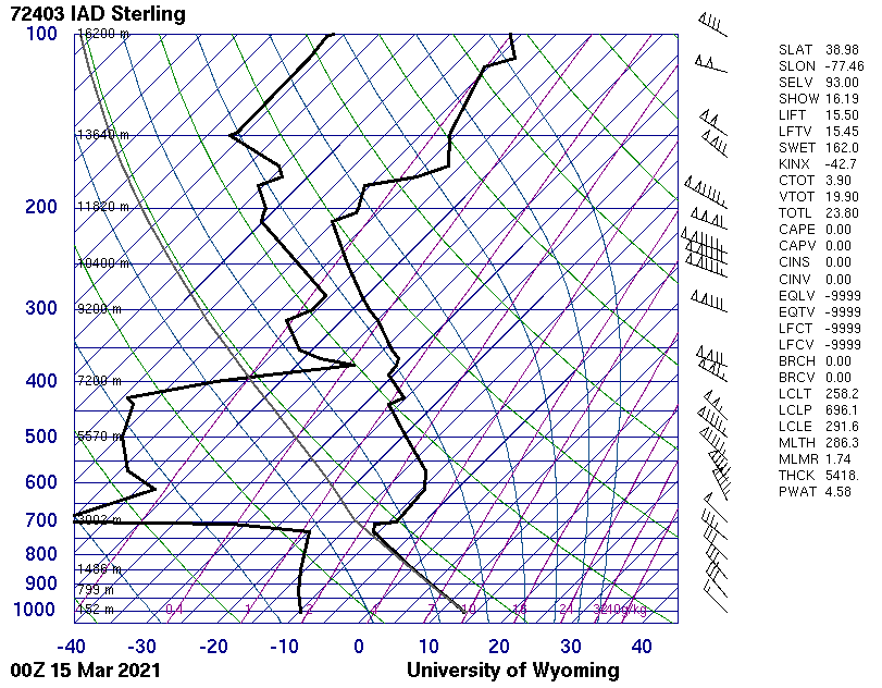
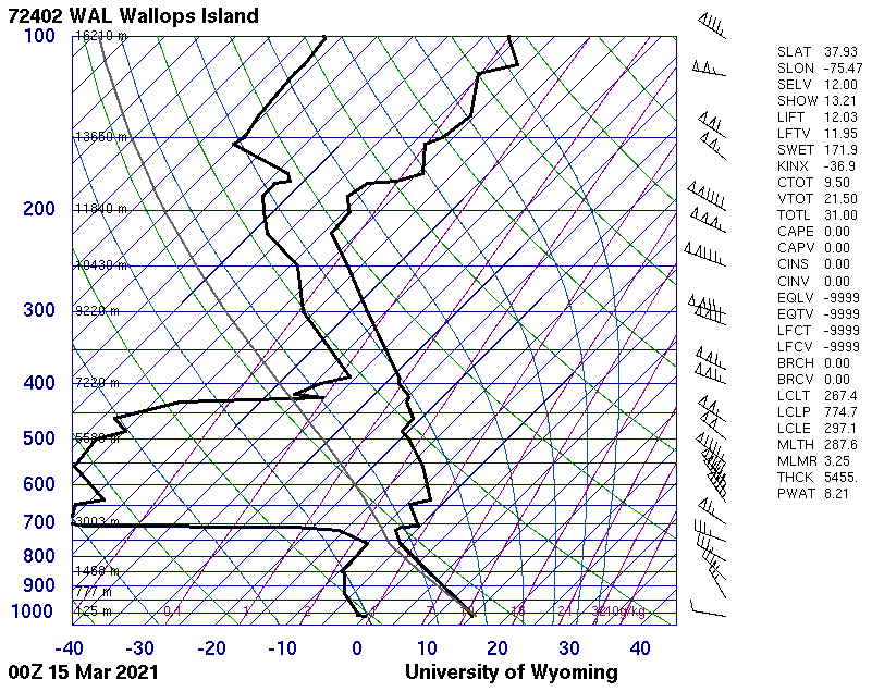
Observed Soundings (Courtesy of SPC and the University of Wyoming)
 |
 |
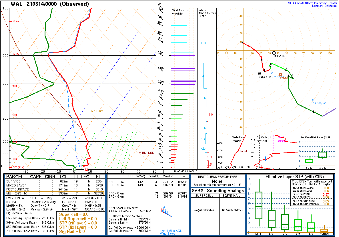 |
| Figure 26: Long Island, NY sounding from 00z March 14. | Figure 27: Sterling, VA sounding from 00z March 14. | Figure 28: Wallops Island, VA sounding from 00z March 14. |
 |
 |
 |
| Figure 29: Long Island, NY sounding from 00z March 15. | Figure 30: Sterling, VA sounding from 00z March 15. | Figure 31: Wallops Island, VA sounding from 00z March 15. |
WWUS81 KPHI 140822
RFWPHI

URGENT - FIRE WEATHER MESSAGE
National Weather Service Mount Holly NJ
422 AM EDT Sun Mar 14 2021

DEZ001>004-MDZ012-015-019-020-NJZ007>010-012>027-PAZ060>062-070-
071-101>106-142100-
/O.UPG.KPHI.FW.A.0001.210314T1200Z-210315T1200Z/
/O.NEW.KPHI.FW.W.0001.210314T1200Z-210315T2100Z/
New Castle-Kent-Inland Sussex-Delaware Beaches-Kent MD-
Queen Annes-Talbot-Caroline-Warren-Morris-Hunterdon-Somerset-
Middlesex-Western Monmouth-Eastern Monmouth-Mercer-Salem-
Gloucester-Camden-Northwestern Burlington-Ocean-Cumberland-
Atlantic-Cape May-Atlantic Coastal Cape May-Coastal Atlantic-
Coastal Ocean-Southeastern Burlington-Berks-Lehigh-Northampton-
Delaware-Philadelphia-Western Chester-Eastern Chester-
Western Montgomery-Eastern Montgomery-Upper Bucks-Lower Bucks-
422 AM EDT Sun Mar 14 2021

...RED FLAG WARNING IN EFFECT FROM 8 AM THIS MORNING TO 5 PM EDT
MONDAY...

The National Weather Service in Mount Holly has issued a Red Flag
Warning. It is in effect from 8:00 AM this morning until 5:00 PM
Monday.

* AFFECTED AREAS...Berks County, the Lehigh Valley and
  southeastern Pennsylvania. Also, most of New Jersey, all of
  Delaware, and parts of eastern Maryland.

* TIMING...Through late Monday afternoon.

* WINDS...Northwest increasing to 20 to 25 mph with gusts around
  35 to 40 mph for this afternoon and evening. Northwest 10 to 15
  mph with gusts around 20 mph from late tonight into Monday.

* RELATIVE HUMIDITY...Dropping to around 20 percent this
  afternoon, recovering only to 35 to 40 percent late tonight,
  then falling back to 15 to 20 percent on Monday.

* TEMPERATURES...High mainly in the 50s today and in the upper
  30s to middle 40s on Monday. Lows tonight mostly in the 20s.

* IMPACTS...Gusty winds, very dry air and drying fuels will
  combine to create conditions favorable for the rapid spread of
  wildfires.

PRECAUTIONARY/PREPAREDNESS ACTIONS...

A Red Flag Warning means that critical fire weather conditions
are expected due to a combination of strong winds, low relative
humidity and dry fuels. Any fires that develop may quickly get out
of control and become difficult to contain.

For more information about wildfire danger, burn restrictions,
and wildfire prevention and education, please visit your state
forestry or environmental protection website.

&&

$$

Iovino
FNUS71 KPHI 142217
FWSPHI

Spot Forecast for Lakewood Fire...Lakewood Fire Dept
National Weather Service Mount Holly NJ
617 PM EDT Sun Mar 14 2021

Forecast is based on forecast start time of 1900 EDT on March 14.
If conditions become unrepresentative...contact the National Weather
Service.

Please contact our office if you have questions or concerns with this forecast.

...RED FLAG WARNING IN EFFECT UNTIL 5 PM EDT MONDAY...
...WIND ADVISORY IN EFFECT UNTIL MIDNIGHT EDT TONIGHT...

.DISCUSSION...
A Red Flag Warning is in effect through 5 pm Monday.

Sustained speeds from 20 to 25 mph this evening with gusts
generally in the 30 to 40 MPH range. A few gusts to 45 mph have been
observed at times. Relative humidity values ranging from 20 to 30
percent through the rest of the afternoon.

While the wind should diminish gradually overnight, relative
humidity levels may recover briefly only to about 35 to 40 percent.

Exceptionally dry conditions will continue across the forecast area
Monday with minimum relative humidity values in the mid teens to
around 20% with northwesterly winds around 10-15 mph through the
afternoon hours. Gusts of 15-25 mph are also expected to last into
the afternoon as well, especially across portions of southeastern
Pennsylvania and New Jersey. Therefore, the Red Flag Warning was
extended to cover Monday as well.

Winds are forecast to drop off quickly by the late afternoon, and
thus the Red Flag Warning should be allowed to expire at that time.
Relative humidity values should recover into the 40s and 50s Monday
night with winds becoming light and variable.

.TONIGHT...

Sky/weather.........Mostly clear (5-15 percent).
CWR.................0 percent.
Chance of pcpn......0 percent.
LAL.................No Tstms.
Min temperature.....Around 22.
Max humidity........40 percent.
Wind shift..........None.
Wind (20 ft)........North winds 15 to 21 mph. Gusts up to 39 mph
                    decreasing to 30 mph after midnight.
Mixing height.......3700-5000 ft AGL decreasing to 3200 ft AGL late
                    in the night.

TIME (EDT)      7PM 8PM 9PM 10P 11P MID 1AM 2AM 3AM 4AM 5AM
Sky (%).........12  7   3   3   3   15  12  6   5   3   3
Weather cov.....
Weather type....
Tstm cov........
CWR.............0   0   0   0   0   0   0   0   0   0   0
Chc of pcpn (%).0   0   0   0   0   0   0   0   0   0   0
LAL.............1   1   1   1   1   1   1   1   1   1   1
Temp............46  42  39  37  34  33  31  28  26  25  25
RH..............29  31  31  31  33  34  36  36  37  38  38
20 FT wind dir..NW  N   N   NW  NW  N   N   N   N   N   N
20 FT wind spd..21  20  18  18  17  17  17  16  16  15  15
20 FT wind gust.31  31  30  26  26  26  23  24  24  24  24
Mix hgt (kft)...5.3 4.8 4.9 4.6 4.5 4.5 4.5 4.4 4.1 3.7 3.2

.MONDAY...

Sky/weather.........Sunny (0-10 percent).
CWR.................0 percent.
Chance of pcpn......0 percent.
LAL.................No Tstms.
Max temperature.....Around 39.
Min humidity........15 percent.
Wind shift..........None.
Wind (20 ft)........Northwest winds 12 to 14 mph with gusts to
                    around 23 mph.
Mixing height.......2900-4400 ft AGL.

TIME (EDT)      6AM 7AM 8AM 9AM 10A 11A 12P 1PM 2PM 3PM 4PM 5PM
Sky (%).........2   3   1   1   2   2   3   3   5   4   4   6
Weather cov.....
Weather type....
Tstm cov........
CWR.............0   0   0   0   0   0   0   0   0   0   0   0
Chc of pcpn (%).0   0   0   0   0   0   0   0   0   0   0   0
LAL.............1   1   1   1   1   1   1   1   1   1   1   1
Temp............23  22  22  25  28  31  33  35  36  37  38  39
RH..............38  37  36  31  26  23  22  20  19  18  19  17
20 FT wind dir..N   N   N   N   N   N   N   NW  NW  NW  NW  NW
20 FT wind spd..14  14  14  14  14  14  13  13  13  13  13  12
20 FT wind gust.23  21  22  19  19  19  19  19  18  18  17  16
Mix hgt (kft)...2.9 2.9 2.9 3.3 3.4 3.5 3.8 3.9 4.1 4.3 4.4 4.3

.MONDAY NIGHT...

Sky/weather.........Partly cloudy (25-35 percent) then becoming
                    mostly cloudy (60-70 percent).
CWR.................0 percent.
Chance of pcpn......0 percent.
LAL.................No Tstms.
Min temperature.....Around 26.
Max humidity........52 percent.
Wind shift..........Winds becoming light and variable.
Wind (20 ft)........Northeast winds 5 to 9 mph.
Mixing height.......2100-4000 ft AGL decreasing to around 1000 ft AGL
                    early in the evening.

TIME (EDT)      6PM 7PM 8PM 9PM 10P 11P MID 1AM 2AM 3AM 4AM 5AM
Sky (%).........10  14  20  35  43  47  60  66  73  71  73  73
Weather cov.....
Weather type....
Tstm cov........
CWR.............0   0   0   0   0   0   0   0   0   0   0   0
Chc of pcpn (%).0   0   0   0   0   0   0   0   0   0   0   0
LAL.............1   1   1   1   1   1   1   1   1   1   1   1
Temp............37  35  31  30  29  28  28  27  26  26  26  26
RH..............18  23  30  35  39  42  42  46  48  50  50  52
20 FT wind dir..NW  NW  NW  NW  NW  N   N   N   N   N   NE  NE
20 FT wind spd..9   7   6   5   5   6   5   5   5   5   5   5
20 FT wind gust.14  11  7   6   6       6   6   6   6   6   6
Mix hgt (kft)...4.0 2.1 1.5 1.1 1.0 1.2 1.4 1.4 1.6 1.5 1.4 1.3

$$
Forecaster...O'Brien
Requested by...Kevin Curry
Type of request...WILDFIRE
.TAG 2105296.0/PHI
.DELDT 03/14/21
While not an especially common concern in the mid-Atlantic region, NWS forecasters are nonetheless responsible for the prediction of hazardous fire weather conditions. A condition of elevated fire weather occurs when a combination of low humidity, high winds, and dry fuels (i.e. grasses, underbrush, etc.) are present. Such conditions occur frequently and are often severe in some parts of the US, especially the West, where extreme combinations of low humidity and high winds in more arid climates can fuel explosive wildfire behavior. In the mid-Atlantic, such combinations occur infrequently. When they do occur, it is typically during the springtime, following the dissipation of any snowpack and before vegetation has blossomed for the season, which dramatically increases fuel moisture.
The meteorological conditions during the daytime on March 14 were of the quintessential variety for an elevated fire weather day in the mid-Atlantic. Multiple preceding cold frontal passages had created a westerly flow regime over the area. Strong high pressure over the northern Great Lakes combined with another approaching frontal system over New England helped to strengthen the pressure gradient, causing westerly winds to become strong, with gusts of over 40 mph across the region. A Wind Advisory was issued due to the strength of the winds. The air mass was very dry, with relative humidity values falling below 30% and locally below 20% during the day on March 14. Finally, because the series of preceding cold fronts had come through with nearly zero precipitation, and with drier than normal conditions for the preceding few weeks, fuel sources were also dry. This led to an unusually potent combination of fire weather ingredients over the mid-Atlantic during the daytime hours of March 14. These conditions created a challenge for firefighters in containing local brush fires, of which numerous cases were reported. This included an approximately 170 acre fire in the area of Lakewood, NJ. That fire, determined to be intentionally set, broke out in the early afternoon hours, and could not be fully contained until the following day due to the uncooperative meteorological conditions. Figures 1 and 2 show a locally produced mesoanalysis of wind gusts and temperatures around 3:45 PM local time. Note that the wind gust product has a large overall low bias due to a lack of official (10 meter elevation) observation sites. Widespread Sub-30%, and locally sub-20%, humidity values can be seen.
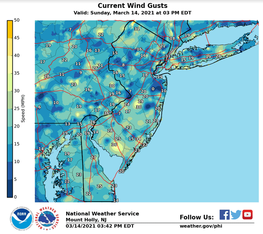 |
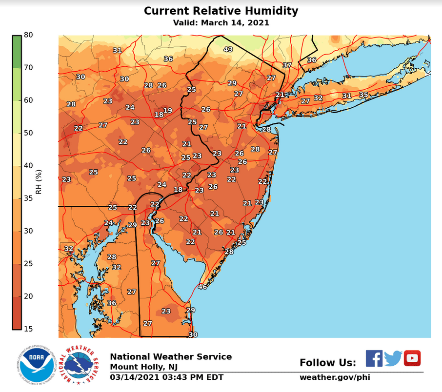 |
| Figure 1: Wind gust analysis around 3:45 PM EDT 14 March 2021. | Figure 2: Relative humidity analysis around 3:45 PM EDT 14 March 2021. |
More unusual in this event were the conditions present during the overnight hours of March 14. Another cold front moved through the region during the early evening hours of the 14th, which once again came through without any rainfall. Behind this front, very dry and windy conditions, at or near Red Flag Warning criteria, continued for most of the night. This behavior is highly anomalous. A primary reason that mid-Atlantic fire weather tends to be less severe than western US fire weather is that there is usually a strong degree of “overnight recovery” – the tendency for humidity values to rise overnight as the boundary layer cools and often decouples, and the temperature falls closer to the dew point value. This tends to confine our local fire weather events to the daytime hours. Conversely, areas such as southern California can see long duration fire weather events due to strong, dry Santa Ana winds which prevent the overnight recovery. In an atypical occurrence, something similar happened over the mid-Atlantic on the night of March 14. The evening frontal passage brought a renewed round of higher winds to the area, helped draw in even drier air as winds veered more northwesterly, and prevented the boundary layer from decoupling as mixing continued throughout the night. It is not uncommon for the boundary layer to remain well-mixed overnight following cold frontal passages. However, it is quite rare for humidity values to remain at or below 30% through the overnight hours in such conditions. Usually, falling temperatures behind the front, even in conjunction with falling dew points, will prevent relative humidity from falling much below 50% overnight. In this case, temperatures fell only slowly due to the strength of mixing and relatively gradual rate of cold air advection aloft. Meanwhile, the already low dew points fell even more, causing the humidity values to remain in the area of 30%. This caused high fire danger conditions to be present throughout the night. Figures 3 and 4 are the same as Figures 1 and 2, for 1:45 AM local time on the 15th. The wind gust data again has a sizable low bias. The humidity values are a bit higher than during the day, but many areas are still near or even below 30%.
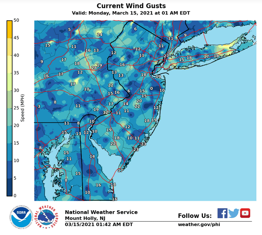 |
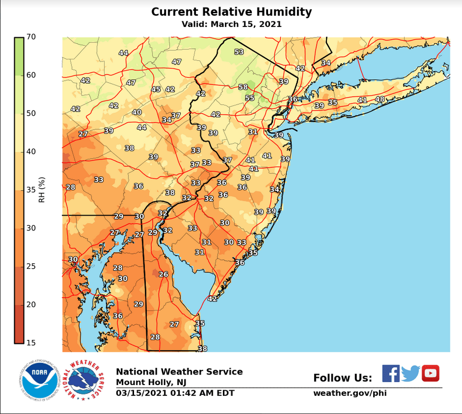 |
| Figure 3: Wind gust analysis around 1:45 AM EDT 15 March 2021. | Figure 4: Relative humidity analysis around 1:45 AM EDT 15 March 2021. |
By March 15, high fire danger conditions still remained, with afternoon RH values on the 15th comparable to and locally even lower than the afternoon of the 14th. However, while the air remained extremely dry, winds began to weaken later in the day as the pressure gradient slackened, and while not a large contributor to fire weather danger, colder temperatures also helped mitigate the risk. By March 16, a changing weather pattern had ended this multi-day fire weather episode.


 Coastal Flood
 Marine Forecasts
 Text Products
 Climate Information
 Skywarn
 Submit Storm Report
 Weather Event Archives
 Forecast Discussion
 Emergency Managers
 Briefing Page