
A heat wave over the Southwest will intensify this week, peaking and expanding into the Intermountain West and northern High Plains this weekend. Critical to extremely critical fire weather conditions are forecast from the Northwest and the northern Great Basin this weekend. Particularly Dangerous Situation Red Flag Warnings have been issued. Read More >
Overview
|
Only a few days removed from Tropical Storm Isaias, another impactful weather event occurred over portions of the mid-Atlantic. A stalled frontal boundary waffled across the Delmarva region and southern New Jersey over the course of the day, with a couple weak waves of low pressure tracking along it. An environment of moderate instability and moderate wind shear developed along the front. In addition, the atmosphere was moisture-laden with dew points around 70F and high values of precipitable water. A cluster of severe thunderstorms developed along the front in southeast Pennsylvania during the late afternoon and moves east-southeast into portions of Delmarva and southern New Jersey through the evening. The worst of the impacts occurred in New Castle County, DE and Chester and Delaware Counties in PA. An EF1 tornado occurred in New Castle County, with several nearby areas of straight line wind damage. In addition, storms were slow moving and training over top of each other in the moist air mass. An area of 2 to 4 inches of rain occurred with localized totals over 6 inches. This led to significant flash flooding of both streets and streams. While not an especially classic high end severe weather environment, it is likely that complex storm-scale interactions and the close proximity of the frontal boundary caused a localized but significant enhancement of the severe weather and flash flooding threat in the areas discussed above. This case serves as a good example of how small scale features associated with severe convective weather can sometimes produce results different than what the synoptic environment would suggest. |
 KDOX radar reflectivity loop, at one half hour intervals from 5PM EDT to 9PM EDT, of the thunderstorms which produdced severe weather and flash flooding on 7 August 2020. The red dot north of Wilmington, DE denotes the approximate location of where an EF1 tornado occured. |
Synoptic Overview at 12z 7 Aug 2020 (courtesy of SPC)
 |
 |
 |
| Figure 1: 250-mb analysis | Figure 2: 300-mb analysis | Figure 3: 500-mb analysis |
 |
 |
 |
| Figure 4: 700-mb analysis | Figure 5: 850-mb analysis | Figure 6: 925-mb analysis |
Synoptic Overview at 00z 8 Aug 2020 (courtesy of SPC)
 |
 |
 |
| Figure 7: 250-mb analysis | Figure 8: 300-mb analysis | Figure 9: 500-mb analysis |
 |
 |
 |
| Figure 10: 700-mb analysis | Figure 11: 850-mb analysis | Figure 12: 925-mb analysis |
Surface Maps (courtesy of SPC)
 |
 |
 |
| Figure 13: 15z surface map | Figure 14: 18z surface map | Figure 15: 21z surface map |
 |
 |
 |
| Figure 16: 00z surface map | Figure 17: 03z surface map | Figure 18: 06z surface map |
 |
 |
 |
| Figure 22: 00z Wallops Island, VA sounding | Figure 23: 00z Sterling, VA sounding | Figure 24: 00z Islip, NY sounding |
 |
 |
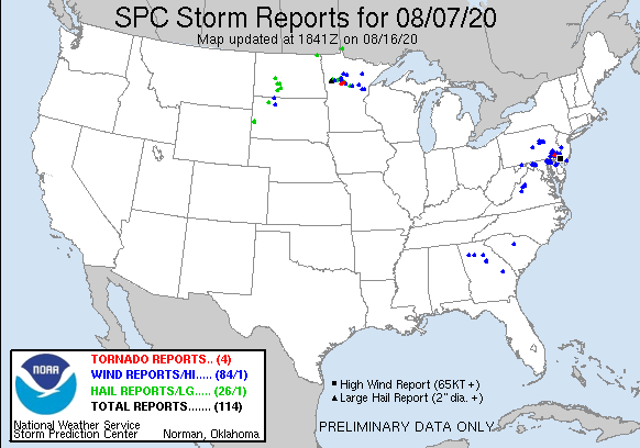
 |
| Figure 1: National Preliminary Reports 12z 7 Aug 2020 to 12z 8 Aug 2020 | Figure 2: Zoomed Preliminary Reports for the same period. | Figure 3: Prelim Reports vs. 0600z SPC Convective Outlook |
Click here for a county warning area based plot of local storm reports and warnings/advisories issued for the 7 Aug 2020 event.
NWUS51 KPHI 121446
LSRPHI
PRELIMINARY LOCAL STORM REPORT...SUMMARY
NATIONAL WEATHER SERVICE MOUNT HOLLY NJ
1046 AM EDT WED AUG 12 2020
...STORM REPORTS FROM AUGUST 7...
..TIME... ...EVENT... ...CITY LOCATION... ...LAT.LON...
..DATE... ....MAG.... ..COUNTY LOCATION..ST.. ...SOURCE....
..REMARKS..
0502 PM TSTM WND DMG 2 NNW SADSBURYVILLE 40.00N 75.91W
08/07/2020 CHESTER PA DEPT OF HIGHWAYS
DOWN TREE IN WIRES ON OLD WILMINGTON ROAD
AND OAK STREET. TIME ESTIMATED FROM RADAR.
0503 PM TSTM WND DMG MOUNT VERNON 39.81N 76.02W
08/07/2020 CHESTER PA DEPT OF HIGHWAYS
DOWNED TREE INTO WIRES ON PA 472 NEAR
OXFORD. TIME ESTIMATED FROM RADAR.
0505 PM TSTM WND DMG COCHRANVILLE 39.89N 75.92W
08/07/2020 CHESTER PA 911 CALL CENTER
TREE BLOWN DOWN BLOCKING SOUTHBOUND LANE AT
THE INTERSECTION OF LIMESTONE RD AND GAP
NEWPORT PIKE. TIME ESTIMATED FROM RADAR.
0508 PM TSTM WND DMG 1 NE LONDONDERRY TWP 39.87N 75.88W
08/07/2020 CHESTER PA FIRE DEPT/RESCUE
SEVERAL TREES DOWN ALONG PORTIONS OF ROUTE
41. TIME ESTIMATED FROM RADAR.
0512 PM TSTM WND DMG 1 SSW EAST BRANDYWINE T 40.02N 75.77W
08/07/2020 CHESTER PA UTILITY COMPANY
SEVERAL TREES AND POLES DOWN JUST NORTH OF
FISHERVILLE ROAD. TIME ESTIMATED FROM RADAR.
0525 PM TSTM WND GST 2 E LONDONDERRY TWP 39.86N 75.84W
08/07/2020 E52 MPH CHESTER PA MESONET
52 MPH WIND GUST MEASURED AT WEST GROVE DEOS
(DSCR) MESONET.
0527 PM FLASH FLOOD PARKESBURG 39.96N 75.92W
08/07/2020 CHESTER PA LAW ENFORCEMENT
WATER RESCUE REPORTED AT MAPLE ST AND S
CULVERT ST IN PARKESBURG BOROUGH. TIME
ESTIMATED FROM DISPATCH.
0538 PM TSTM WND DMG HOCKESSIN 39.79N 75.69W
08/07/2020 NEW CASTLE DE BROADCAST MEDIA
SOME TREES DOWN IN HOCKESSIN. TIME ESTIMATED
FROM RADAR.
0540 PM TSTM WND DMG 1 SE WEST GOSHEN 39.96N 75.56W
08/07/2020 CHESTER PA DEPT OF HIGHWAYS
DOWNED TREE IN WIRES ON WESTTOWN THORNTON
ROAD AND FIVE POINTS ROAD. TIME ESTIMATED
FROM RADAR.
0540 PM TORNADO ASHLAND 39.80N 75.66W
08/07/2020 NEW CASTLE DE NWS STORM SURVEY
AN EF1 TORNADO WITH WINDS TO 105 MPH TOUCHED
DOWN IN ASHLAND AND TRACKED TO MONTCHANIN IN
NORTHERN DELAWARE. NUMEROUS TREES WERE
DOWNED, SNAPPED OR UPROOTED. A NOTED
CONVERGENT PATTERN IN THE DEBRIS WAS
OBSERVED IN THE TREE DAMAGE ACROSS THE
WILMINGTON COUNTRY CLUB.
0541 PM TSTM WND DMG 1 W GREENVILLE 39.78N 75.62W
08/07/2020 NEW CASTLE DE NWS STORM SURVEY
SIGNIFICANT STRAIGHT-LINE WIND DAMAGE
OCCURRED DUE TO A SEVERE REAR-FLANK
DOWNDRAFT WITH WINDS UP TO 95 MPH. THIS
OCCURRED FROM GREENVILLE TO WILMINGTON IN
NORTHERN DELAWARE. QUITE A BIT OF TREE
DAMAGE OCCURRED INCLUDING A TREE SNAPPED AT
ITS BASE. THE SIGNIFICANT DAMAGE ENDED NEAR
THE DELAWARE ART MUSEUM IN THE KENTMERE
SECTION OF WILMINGTON. SPORADIC DAMAGE
CONTINUED EAST TOWARD THE INTERSECTION OF
I-95 AND CONCORD PIKE WHERE UTILITY
COMPANIES HAD TO REMOVE DEBRIS FROM THE
POWER LINES AND ADDITIONAL TREES WERE
KNOCKED DOWN IN HAYNES PARK.
0545 PM FLASH FLOOD HOCKESSIN 39.79N 75.69W
08/07/2020 NEW CASTLE DE BROADCAST MEDIA
SIGNIFICANT FLOODING ACROSS LANCASTER PIKE
IN HOCKESSIN WITH AT LEAST ONE CAR STUCK IN
THE FLOOD WATERS.
0550 PM TSTM WND DMG 2 SE EAST NANTMEAL TWP 40.11N 75.69W
08/07/2020 CHESTER PA LAW ENFORCEMENT
TREE REPORTED DOWN AT BLACK HORSE RD IN WEST
VINCENT TOWNSHIP. TIME ESTIMATED FROM
DISPATCH.
0550 PM TSTM WND DMG 1 N MONTCHANIN 39.80N 75.59W
08/07/2020 NEW CASTLE DE PUBLIC
TREES AND WIRES DOWN ALONG MONTCHANIN RD
NORTH OF WILMINTON. TIME ESTIMATED BY RADAR.
0550 PM TSTM WND DMG WEST HAVEN 39.76N 75.59W
08/07/2020 NEW CASTLE DE TRAINED SPOTTER
NUMEROUS TREES DOWN OR SNAPPED WITH SOME
ONTO HOMES. TIME ESTIMATED FROM RADAR.
0550 PM TSTM WND DMG 1 NE WOODDALE 39.78N 75.62W
08/07/2020 NEW CASTLE DE PUBLIC
SEVERAL TREES DOWN ALONG CENTERVILLE ROAD IN
WESTERN GREENVILLE. TIME ESTIMATED FROM
RADAR AND NEARBY REPORTS.
0550 PM TSTM WND DMG GREENVILLE 39.78N 75.60W
08/07/2020 NEW CASTLE DE PUBLIC
TREES DOWN IN GREENVILLE. TIME ESTIMATED BY
RADAR.
0552 PM FLASH FLOOD 1 S KENNETT SQUARE 39.84N 75.71W
08/07/2020 CHESTER PA LAW ENFORCEMENT
ONE VEHICLE STUCK IN RISING WATER AT SOUTH
ST. AND HARVEY CIRCLE IN KENNETT SQUARE.
TIME ESTIMATED FROM DISPATCH.
0552 PM TSTM WND DMG GREENVILLE MANOR 39.78N 75.60W
08/07/2020 NEW CASTLE DE PUBLIC
TREES AND POWER POLES DOWN IN GREENVILLE.
TIME ESTIMATED FROM RADAR.
0555 PM TSTM WND DMG ROCK MANOR 39.77N 75.55W
08/07/2020 NEW CASTLE DE BROADCAST MEDIA
LARGE TREE UPROOTED AND BLOCKING SCHOOL ROAD
IN ALAPOCAS. TIME ESTIMATED FROM RADAR.
0555 PM TSTM WND DMG WILMINGTON 39.75N 75.55W
08/07/2020 NEW CASTLE DE BROADCAST MEDIA
TREES DOWN OR SNAPPED ON NORTH MADISON
STREET BETWEEN WEST 9TH AND WEST 10TH
STREETS IN WILMINGTON. TIME ESTIMATED FROM
RADAR.
0555 PM TSTM WND DMG PHILLIPS HEIGHTS 39.77N 75.51W
08/07/2020 NEW CASTLE DE AMATEUR RADIO
TREE DOWN ONTO POWER LINES AT WILMINGTON
WASHINGTON STREET EXTENSION AND HANOVER ROAD
IN NORTH WILMINGTON. TIME ESTIMATED FROM
RADAR.
0555 PM TSTM WND GST WINTERTHUR 39.80N 75.61W
08/07/2020 M54 MPH NEW CASTLE DE MESONET
GREENVILLE DEOS (DGRN) MEASURED A 54 MPH
WIND GUST.
0556 PM FLOOD 2 S KENNETT SQUARE 39.81N 75.71W
08/07/2020 CHESTER PA 911 CALL CENTER
STREAM WAS REPORTED BLOCKED AND CREATING A
LAKE ON THE ROADWAY AT THE INTERSECTION OF
BUCKTOE RD. AND CHANDLER MILL RD.
0557 PM TSTM WND DMG EDGEMOOR GARDENS 39.76N 75.50W
08/07/2020 NEW CASTLE DE FIRE DEPT/RESCUE
TREE ONTO A HOUSE WITH PEOPLE TRAPPED IN
EDGEMOOR GARDENS. POWER LINES DOWN. TIME
ESTIMATED FROM RADAR.
0558 PM FLASH FLOOD 1 NE TOUGHKENAMON 39.84N 75.75W
08/07/2020 CHESTER PA LAW ENFORCEMENT
ROADWAY FLOODED AT BANCROFT RD AND CRESTVIEW
DR IN NEW GARDEN TOWNSHIP. TIME ESTIMATED
FROM DISPATCH.
0603 PM FLASH FLOOD 1 ESE TRAINER 39.83N 75.39W
08/07/2020 DELAWARE PA 911 CALL CENTER
WATER RESCUE REPORTED.
0603 PM FLASH FLOOD 1 S KENNETT SQUARE 39.84N 75.71W
08/07/2020 CHESTER PA 911 CALL CENTER
WATER RESCUE AT THE INTERSECTION OF SOUTH
STREET AND HARVEY CIRCLE.
0609 PM TSTM WND DMG WINTERTHUR 39.80N 75.61W
08/07/2020 NEW CASTLE DE TRAINED SPOTTER
TREES AND WIRES DOWN AT KENNETT PIKE AND OLD
KENNETT ROAD.
0610 PM FLASH FLOOD ASTON TWP. 39.86N 75.43W
08/07/2020 DELAWARE PA LAW ENFORCEMENT
WATER RESCUE AT WEIR RD AND PENNELL RD. TIME
ESTIMATED FROM DISPATCH.
0610 PM FLASH FLOOD 1 NW ASHLAND 39.81N 75.67W
08/07/2020 NEW CASTLE DE TRAINED SPOTTER
A HOME IN YORKLYN WAS TAKING ON WATER.
0611 PM FLASH FLOOD ASTON TWP. 39.86N 75.42W
08/07/2020 DELAWARE PA LAW ENFORCEMENT
WATER RESCUE REPORTED ON RAYMOND AVENUE IN
ASHTON TOWNSHIP.
0612 PM FLASH FLOOD GREEN RIDGE 39.87N 75.41W
08/07/2020 DELAWARE PA LAW ENFORCEMENT
ROAD CLOSURE AT E DUTTON MILL RD AND CHESTER
CREEK RD. TIME ESTIMATED FROM DISPATCH.
0615 PM FLASH FLOOD UPPER CHICHESTER TWP 39.86N 75.46W
08/07/2020 DELAWARE PA PUBLIC
PICTURE SHOWS DEEP WATER CLOSING A ROAD IN
UPPER CHICHESTER TOWNSHIP. TIME ESTIMATED
FROM RADAR AND NEARBY REPORTS.
0615 PM TSTM WND DMG MEDIA 39.92N 75.39W
08/07/2020 DELAWARE PA TRAINED SPOTTER
SEVERAL TREES DOWN ACROSS THE SOUTHERN
PORTION OF DELAWARE COUNTY. TIME ESTIMATED
FROM RADAR.
0615 PM FLASH FLOOD 2 N AVONDALE 39.85N 75.79W
08/07/2020 CHESTER PA 911 CALL CENTER
WATER RESCUE AT THE INTERSECTION OF MCCUE
ROAD AND WOODVIEW ROAD.
0616 PM FLASH FLOOD 1 WNW SPRINGFIELD TWP 39.94N 75.35W
08/07/2020 DELAWARE PA LAW ENFORCEMENT
CORRECTS PREVIOUS FLASH FLOOD REPORT FROM 1
WNW SPRINGFIELD TWP. WATER RESCUE REPORTED
ON OLD MARPLE RD MARPLE TOWNSHIP. TIME
ESTIMATED FROM DISPATCH.
0617 PM FLASH FLOOD ASTON TWP. 39.87N 75.43W
08/07/2020 DELAWARE PA LAW ENFORCEMENT
WATER RESCUE REPORTED AT CONCORD RD IN
ASHTON TOWNSHIP.
0621 PM FLASH FLOOD 3 S KENNETT SQUARE 39.80N 75.71W
08/07/2020 CHESTER PA LAW ENFORCEMENT
CREEK FLOODING AT KAOLIN RD AND CALDWELL LN.
ROAD CLOSED. TIMES ESTIMATED FROM DISPATCH.
0625 PM FLASH FLOOD 1 ESE LANDENBERG 39.77N 75.74W
08/07/2020 CHESTER PA LAW ENFORCEMENT
CORRECTS PREVIOUS FLASH FLOOD REPORT FROM 1
ESE LANDENBERG. BROAD RUN RD AT NEWARK RD
ROAD CLOSED DUE TO HIGH WATER. TIME
ESTIMATED FROM DISPATCH.
0626 PM FLASH FLOOD 1 ENE CONCORDVILLE 39.89N 75.51W
08/07/2020 DELAWARE PA LAW ENFORCEMENT
WATER RESCUE AT BALTIMORE PIKE AND CHEYNEY
RD. TIME ESTIMATED FROM DISPATCH.
0630 PM FLASH FLOOD 1 SSW KENNETT SQUARE 39.83N 75.72W
08/07/2020 CHESTER PA LAW ENFORCEMENT
WATER RESCUE AT W HILLENDALE RD AND CHANDLER
MILL RD. TIME BASED OFF OF DISPATCH.
0640 PM HEAVY RAIN ASTON TWP. 39.87N 75.43W
08/07/2020 M3.51 INCH DELAWARE PA PUBLIC
3.51 INCHES OF RAIN IN 50 MINUTES ENDING AT
6:40 PM.
0640 PM FLASH FLOOD 1 SSW BOOTHWYN 39.82N 75.45W
08/07/2020 DELAWARE PA PUBLIC
PICTURE ON SOCIAL MEDIA SHOWS FLOODING AT A
LOCAL BUSINESS NEAR THE WEST BRANCH NAAMAN
CREEK. TIME ESTIMATED FROM RADAR AND NEARBY
REPORTS.
0650 PM TSTM WND DMG YARDLEY 40.24N 74.84W
08/07/2020 BUCKS PA 911 CALL CENTER
SEVERAL TREES AND WIRES REPORTED DOWN IN THE
AREA OF YARDLEY AND WOODSIDE. TIME ESTIMATED
FROM RADAR.
0650 PM TSTM WND DMG WOODSTOWN 39.66N 75.33W
08/07/2020 SALEM NJ PUBLIC
SOME TREES DOWN IN THE WOODSTOWN AREA. TIME
ESTIMATED FROM RADAR.
0655 PM FLOOD 2 E PILESGROVE TWP 39.67N 75.36W
08/07/2020 SALEM NJ TRAINED SPOTTER
FLOODING ON KINGS HIGHWAY.
0700 PM FLASH FLOOD MIDDLETOWN TWP. 39.92N 75.42W
08/07/2020 DELAWARE PA TRAINED SPOTTER
ROUTE 1 CLOSED IN SEVERAL LOCATIONS DUE TO
FLOODING.
0700 PM TSTM WND DMG 2 SW GLENDORA 39.82N 75.09W
08/07/2020 GLOUCESTER NJ DEPT OF HIGHWAYS
DOWNED TREE, POLE AND WIRES ON NJ 41 BOTH
DIRECTIONS NORTH OF GOOD INTENT ROAD IN
DEPTFORD TOWNSHIP. ALL LANES CLOSED. TIME
ESTIMATED FROM RADAR.
0700 PM FLASH FLOOD LOGAN TWP. 39.80N 75.35W
08/07/2020 GLOUCESTER NJ PUBLIC
CARS STUCK IN FLOODED WATER, KNEE HIGH DEEP
WATER IN SOME AREAS. TIME ESTIMATED RADAR.
0705 PM TSTM WND GST 2 NNE SEABROOK FARMS 39.53N 75.20W
08/07/2020 M89 MPH CUMBERLAND NJ MESONET
RUTGERS AGRICULTURAL RESEARCH AND EXTENSION
CENTER AT UPPER DEERFIELD, NJ.
0715 PM FLASH FLOOD WOOLWICH TWP 39.76N 75.31W
08/07/2020 GLOUCESTER NJ TRAINED SPOTTER
WIDESPREAD FLASH FLOODING OF ROADS AND
PROPERTIES REPORTED IN SWEDESBORO.
0717 PM TSTM WND GST 4 NNW SEABROOK FARMS 39.55N 75.24W
08/07/2020 M69 MPH CUMBERLAND NJ TRAINED SPOTTER
69 MPH THUNDERSTORM WIND GUST MEASURED ON
ROUTE 77 AT MILE MARKER 9.
0720 PM FLASH FLOOD 3 N PILESGROVE TWP 39.71N 75.38W
08/07/2020 SALEM NJ DEPT OF HIGHWAYS
FLOODING ACROSS THE NEW JERSEY TURNPIKE BOTH
DIRECTIONS BETWEEN THE DELAWARE MEMORIAL
BRIDGE AND US 322. ALL LANES ARE BLOCKED.
0721 PM TSTM WND DMG STILL POND 39.33N 76.04W
08/07/2020 KENT MD DEPT OF HIGHWAYS
DELAYED REPORT. WIND-BLOWN DEBRIS CLOSED
STATE HIGHWAY 292 NEAR STATE HIGHWAY 566.
TIME ESTIMATED FROM RADAR.
0728 PM TSTM WND DMG 3 SSE KENTON 39.19N 75.65W
08/07/2020 KENT DE UTILITY COMPANY
DELAYED REPORT. DOWNED TREE AND WIRES NEAR
SHAWS CORNER ROAD SOUTHEAST OF KENTON. TIME
ESTIMATED FROM RADAR.
0728 PM TSTM WND DMG 2 SE WOODLAND BEACH 39.31N 75.44W
08/07/2020 KENT DE UTILITY COMPANY
DELAYED REPORT. DOWNED TREE AND WIRES NEAR
WOODLAND BEACH. TIME ESTIMATED FROM RADAR.
0744 PM TSTM WND DMG TEMPLEVILLE 39.14N 75.77W
08/07/2020 QUEEN ANNES MD DEPT OF HIGHWAYS
DELAYED REPORT. WIND-BLOWN DEBRIS CLOSED
STATE HIGHWAY 302 NEAR BEAR POND ROAD. TIME
ESTIMATED FROM RADAR.
0745 PM TSTM WND DMG 1 NW MINOTOLA 39.53N 74.96W
08/07/2020 ATLANTIC NJ PUBLIC
TELEPHONE PONES SNAPPED IN HALF WITH WIRES
DOWN ON BREWSTER AND FOREST GROVE ROADS.
TIME ESTIMATED BY RADAR.
0745 PM FLASH FLOOD SUDLERSVILLE 39.19N 75.86W
08/07/2020 QUEEN ANNES MD DEPT OF HIGHWAYS
MD 313 CLOSED AT CHARLES STREET DUE TO HIGH
WATER.
0800 PM FLOOD NEWFIELD 39.55N 75.02W
08/07/2020 GLOUCESTER NJ PUBLIC
SOCIAL MEDIA VIDEO SHOWS SEVERE BACKYARD
FLOODING. TIME ESTIMATED FROM RADAR.
0828 PM FLASH FLOOD 1 NW BUENA 39.53N 74.95W
08/07/2020 ATLANTIC NJ DEPT OF HIGHWAYS
DELAYED REPORT. FLASH FLOODING CLOSED U.S.
HIGHWAY 40 BETWEEN MALAGA ROAD AND EAST
SUMMER ROAD IN BUENA. TIME BASED ON DISPATCH
REPORT.
0835 PM FLASH FLOOD 1 NW VINELAND 39.50N 75.04W
08/07/2020 CUMBERLAND NJ DEPT OF HIGHWAYS
DELAYED REPORT. FLASH FLOODING CLOSED STATE
HIGHWAY 47 IN AREA OF OAK ROAD IN VINELAND.
TIME BASED ON DISPATCH REPORT.
0846 PM FLASH FLOOD 2 SW MILLINGTON 39.24N 75.87W
08/07/2020 QUEEN ANNES MD DEPT OF HIGHWAYS
DELAYED REPORT. FLASH FLOODING CLOSED STATE
HIGHWAY 313 NEAR STATE HIGHWAY 544. TIME
BASED ON DISPATCH REPORT.
0850 PM TSTM WND DMG 1 ENE SEAVILLE 39.22N 74.68W
08/07/2020 CAPE MAY NJ TRAINED SPOTTER
CORRECTS PREVIOUS TSTM WND DMG REPORT FROM 1
ENE SEAVILLE. TREE DOWN ON GARDEN STATE
PARKWAY NEAR MILE MARKER 21.9. TIME
ESTIMATED BY RADAR.
0850 PM HEAVY RAIN VILLAS 39.03N 74.94W
08/07/2020 M1.00 INCH CAPE MAY NJ TRAINED SPOTTER
1 INCH OF RAIN IN JUST 10 MINUTES IN THE
VILLAS MIAMI BEACH SECTION.
0850 PM HEAVY RAIN DENNISVILLE 39.20N 74.82W
08/07/2020 M1.10 INCH CAPE MAY NJ TRAINED SPOTTER
1.10 INCHES OF RAIN IN JUST 9 MINUTES.
0854 PM MARINE TSTM WIND LUDLAM BAY 39.18N 74.70W
08/07/2020 E47 MPH ANZ453 NJ PUBLIC
41 KNOTS AT LUDLAM BAY.
0907 PM FLASH FLOOD SUDLERSVILLE 39.19N 75.86W
08/07/2020 QUEEN ANNES MD DEPT OF HIGHWAYS
DELAYED REPORT. FLASH FLOODING CLOSED STATE
HIGHWAY 300 AT STATE HIGHWAY 837. TIME BASED
ON DISPATCH REPORT.
0938 PM FLASH FLOOD 1 N NORTH WILDWOOD 39.01N 74.80W
08/07/2020 CAPE MAY NJ DEPT OF HIGHWAYS
DELAYED REPORT. FLASH FLOODING CLOSED STATE
HIGHWAY 147 NEAR MARYLAND AVENUE IN NORTH
WILDWOOD. TIME BASED ON DISPATCH REPORT.
0940 PM FLASH FLOOD 2 NW CARDIFF 39.43N 74.61W
08/07/2020 ATLANTIC NJ DEPT OF HIGHWAYS
DELAYED REPORT. FLASH FLOODING CLOSED U.S.
HIGHWAY 40 NEAR ENGLISH CREEK AVENUE. TIME
BASED ON DISPATCH REPORT.
0945 PM FLASH FLOOD ELKTON 39.61N 75.82W
08/07/2020 CECIL MD PUBLIC
WATER RESCUE ON DELAWARE AVE NEAR MEADOW
PARK. ROAD WAS CLOSED DUE TO FLOODING. TIME
ESTIMATED FROM RADAR.
1003 PM FLASH FLOOD 1 S POMONA 39.46N 74.54W
08/07/2020 ATLANTIC NJ DEPT OF HIGHWAYS
DELAYED REPORT. FLASH FLOODING CLOSED U.S.
HIGHWAY 30 NEAR GARDEN STATE PARKWAY. TIME
BASED ON DISPATCH REPORT.
&&
$$
CMS/MJG/LR/MPS/BAH/SFJ/DI
NOUS41 KPHI 101751
PNSPHI
DEZ001>004-MDZ008-012-015-019-020-NJZ001-007>010-012>024-026-027-
PAZ054-055-060>062-070-071-101>106-110600-

Public Information Statement
National Weather Service Mount Holly NJ
151 PM EDT Mon Aug 10 2020

...NWS DAMAGE SURVEY FOR 08/07/20 NEW CASTLE COUNTY DELAWARE TORNADO
AND STRAIGHT LINE WIND EVENT...

.New Castle County, Delaware Tornado...

Start Location...Ashland in New Castle County, Delaware
End Location...Montchanin in New Castle County, Delaware
Date...August 7, 2020
Estimated Time...5:40 PM EDT to 5:51 PM EDT
Maximum EF-Scale Rating...EF1
Estimated Maximum Wind Speed...105 mph
Maximum Path Width...450 yards
Path Length...3.8 miles
Beginning Lat/Lon...39.80/-75.66
Ending Lat/Lon...39.79/-75.58
* Fatalities...0
* Injuries...0

...Summary...
A tornado touched down around 5:40 PM on August 7th close to the
Ashland Nature Center of the Delaware Nature Society or just east
of the intersection of Brackenville Road and Barley Mill Road
where some tree damage occurred. The tornado continued east
southeast to the Swallow Hill area where there were multiple trees
down across Pyles Ford Road. Trees were snapped at the trunk,
with one tree falling on the roof of a house. Pyles Ford Road was
closed due to the amount of tree damage across the road. This wind
damage was estimated to be 105 mph, equivalent to an EF1 on the
Enhanced Fujita Scale.

The tornado continued in an easterly direction where substantial
tree damage occurred just north of Valley Garden Park where over
20 trees were uprooted or damaged. Campbell Road was also closed
due to the multiple trees down. More damage occurred along Kennett
Pike between Kirk Road and the entrance of Wilmington Country
Club where several trees were uprooted along with large tree limbs
knocked down. The tornado continued through the Wilmington
Country Club where approximately 200 trees were damaged. A noted
convergent pattern in the debris was observed in the tree damage
across the Wilmington Country Club. The tornado then continued
eastward before lifting prior to reaching Rockland, Delaware. No
further damage was noted in the DuPont Country Club or on Concord
Pike.

Special thanks is extended to Mr. Lou Ruh, New Castle County
Emergency Management, trained spotters, and the general public for
their extensive assistance with this survey.

.New Castle County, Delaware Straight-line Wind Event...

Location...Greenville and Wilmington in New Castle County Delaware
Date...August 7, 2020
Estimated Time...5:41 PM EDT to 5:59 PM EDT
Estimated Maximum Wind Speed...95 mph
Maximum Path Width...1800 yards
Path Length...4.51 miles
Beginning Lat/Lon...39.78/-75.62
Ending Lat/Lon...39.76/-75.54
* Fatalities...0
* Injuries...0

...Summary...
The straight-line wind damage, separate and south of the tornado
track, was in a mostly divergent pattern and was associated with
the storms severe rear-flank downdraft. The damage began just
east of Hoopes Reservoir with around 4 trees down near the
intersection Centreville Road and Barley Mill Road, and additional
tree damage on Hillside Road. Several trees were uprooted and
fell on wires and poles within the Fairthone section. Additional
trees were uprooted and damaged within the Greenville Manor
section. Damage continued southeastward where several trees and
large branches were knocked down on Buck Road and also in the
Montchan section. Damage continued southward into the Henry Clay
section where damage occurred near the Montchanin Road and Kennett
Pike intersection and continued southeast toward Rising Sun Lane.
Near Rising Sun Lane, in particular, a tree was snapped at the
trunk with damage indicative of near 100 mph winds. Given the less
extensive amount of tree damage in this area compared to the
Wilmington Country Club, have decided to rate the maximum value of
the estimated wind speed at 95 mph. The damage continued into
Wilmington where trees were uprooted along West 19 Street and
Tower Road, south of Rockford Park. Damage continued to the east
side of Rockford Park where trees were knocked down on Rockford
Road. The significant damage ended near the Delaware Art Museum in
the Kentmere section of Wilmington. Sporadic damage continued
east towards the intersection of I-95 and Concord Pike where
utility companies had to remove debris from the power lines and
additional trees were knocked down in Haynes Park.

Special thanks is extended to New Castle County Emergency
Management, Mr. Lou Ruh, trained spotters and the general public
for their extensive assistance with this survey.

EF Scale: The Enhanced Fujita Scale classifies tornadoes into the
following categories:

EF0...Weak......65 to 85 mph
EF1...Weak......86 to 110 mph
EF2...Strong....111 to 135 mph
EF3...Strong....136 to 165 mph
EF4...Violent...166 to 200 mph
EF5...Violent...>200 mph

* The information in this statement is preliminary and subject to
change pending final review of the events and publication in NWS
Storm Data.

$$

Robertson/Haines/Miketta/Johnson/Gorse
Notable Radar Imagery (GR2Analyst)
 |
 |
| Figure 1: KDOX radar reflectivity factor (left) and storm relative velocity (SRM, right) for the 0.5 degree elevation angle valid at 2141 UTC 7 August 2020. This was near the time of the New Castle County tornado touchdown. Rotation is clearly present, but the storm was not exhibiting an especially classic tornadic couplet signature. The core of this storm was quite intense, as evidenced by the sizable area of >60 dBz echoes near the New Castle, DE and Chester, PA county borders. No severe hail was reported, but some suspended hailstones were likely present aloft. | Figure 2: KDOX radar reflectivity factor (top left), storm relative velocity (SRM, top right), spectrum width (SW, bottom left) and correlation coefficient (CC, bottom right) for the 0.5 degree elevation angle valid at 2148 UTC 7 August 2020. The tornado was near its peak intensity at this point, with a better defined though still not particularly tight velocity couplet visible in the SRM data. The large area of elevated SW values also confirms a messy and turbulent storm structure with multiple areas of strong straight line winds in addition to the tornado. No tornado debris signature (TDS) is evident in the CC data, with lowered CC values northwest of the couplet likely associated with hail in the storm core. |
 |
 |
| Figure 3: KDOX radar reflectivity factor (left) and storm relative velocity (SRM, right) for the 0.5 degree elevation angle valid at 2153 UTC 7 August 2020. By this time, the tornado had lifted, and the rear flank downdraft (RFD) was surging ahead of the remnant circulation. This in turn posed a significant straight line wind threat, with damaging wind continuing to occur after the tornado lifted thanks to this strong RFD surge. | Figure 4: KDIX radar reflectivity factor (top left), storm relative velocity (SRM, top right), spectrum width (SW, bottom left) and correlation coefficient (CC, bottom right) for the 0.5 degree elevation angle valid at 2150 UTC 7 August 2020, towards the end of the tornado’s lifetime. The KDIX and KDOX radars were at similar distances away from this tornado, but with very different viewing angles. The KDIX radar shows a slightly better defined SRM couplet. However, the more notable difference is in the SW data, with a well-defined “bullseye” of higher spectrum width values, a signature sometimes associated with tornadoes. Once again, no TDS is seen in the CC data, which was quite messy and also appeared to be contaminated by partial or non-uniform beam filling north of the circulation in the “streak” of significantly reduced CC values. |
 |
 |
| Figure 5: KDIX radar reflectivity factor (left) and storm relative velocity (SRM, right) for the 0.5 degree elevation angle valid at 2155 UTC 7 August 2020, a few minutes after the tornado had lifted. The KDIX radar does a particularly good job showing the transition from a tornadic wind threat to a straight line wind threat, with both the reflectivity and velocity data giving a strong impression that the RFD had surged forward and was producing considerable amounts of wind damage after the tornado lifted. These complexities can make it quite difficult to differentiate the cause of damage during storm surveys for these type of storms. | Figure 6: In addition to severe weather, significant flash flooding occurred on August 7, with storms moving slowly and over top of one another in a moisture laden environment. The radar loop in the Overview section illustrates this, and this map shows observed rainfall values from the Advanced Hydrologic Prediction Service (AHPS) for the 24 hours ending the morning of August 8. A stripe of 2 to 4 inches of rain was recorded, with some locally higher amounts. This produced both roadway and stream flooding, with the Red Clay Creek at Wooddale, DE and the Chester Creek near Chester, PA both reaching major flood stage. There were several reports of road closures and water rescues from vehicles. Saturated ground from the very recent Tropical Storm Isaias exacerbated the flooding problems. |


 Coastal Flood
 Marine Forecasts
 Text Products
 Climate Information
 Skywarn
 Submit Storm Report
 Weather Event Archives
 Forecast Discussion
 Emergency Managers
 Briefing Page