Overview
|
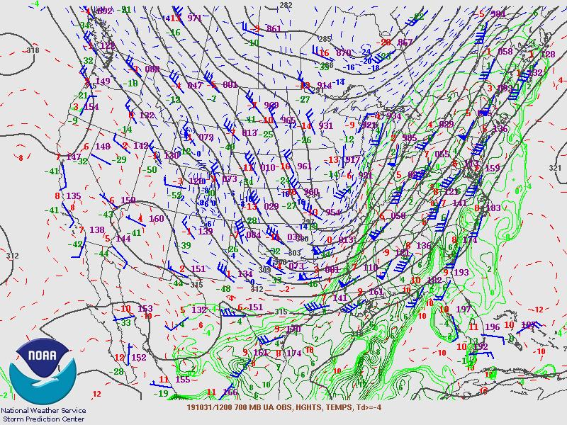
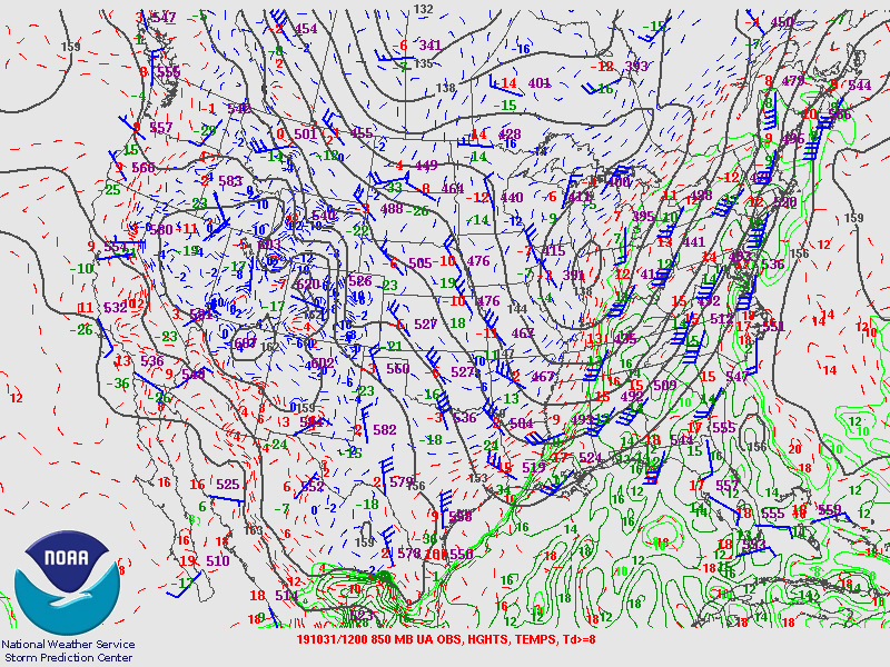
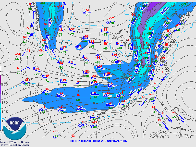
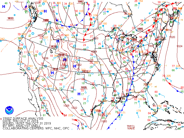
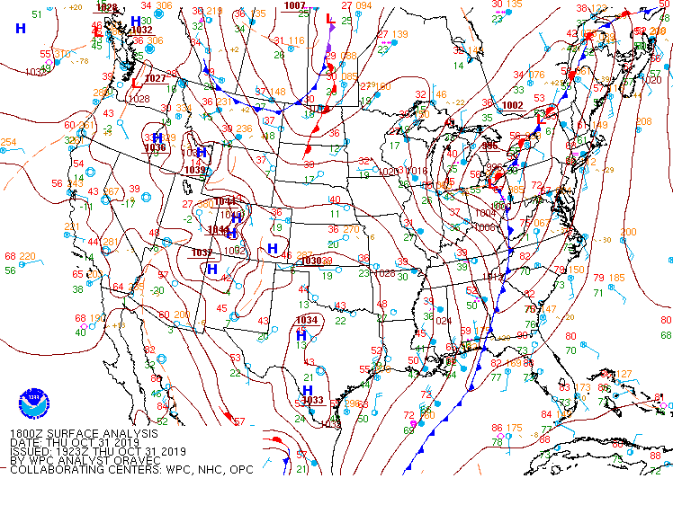
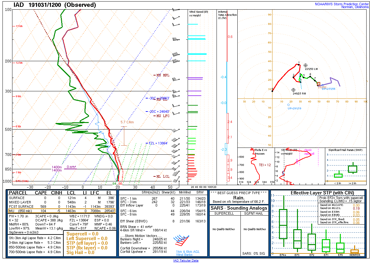
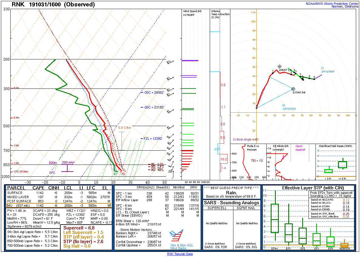
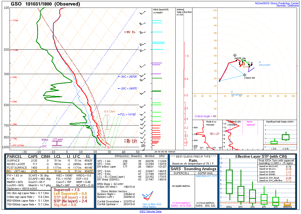
A strong mid-latitude cyclone moved through the eastern Great Lakes region late on 31 October 2019 as a deep trough moved into the east-central US. During the day on October 31, strong southerly flow developed over the mid-Atlantic ahead of a cold front associated with the area of low pressure. This resulted in an anomalously warm Halloween, with high temperatures in the mid to upper 70s and dew points in the 60s. This allowed some modest instability (a few hundred joules of MLCAPE) to build. Meanwhile, exceptionally strong wind fields were present, with 0 to 6 km bulk shear values in the range of 60 to 80 kt. Combined with strong forcing from the approaching front, a broken line of severe thunderstorms moved through the mid-Atlantic during the overnight hours of 31 October into 1 November. Widespread damaging winds occurred as the thunderstorms helped transport down winds associated with a strong low level jet. High values of near surface storm relative helicity also led to areas of rotation developing within the line. An EF2 tornado occurred in Delaware County, PA, and an EF-1 tornado occurred in Morris County, NJ. In addition to severe weather, the motion of the line had a considerable boundary-parallel component, which meant that storms trained over some areas. This led to instances of flash flooding in portions of eastern Pennsylvania and northern New Jersey. Thankfully, no fatalities occurred due to this violent night of weather, but a couple of minor injuries relating to broken glass were reported. |
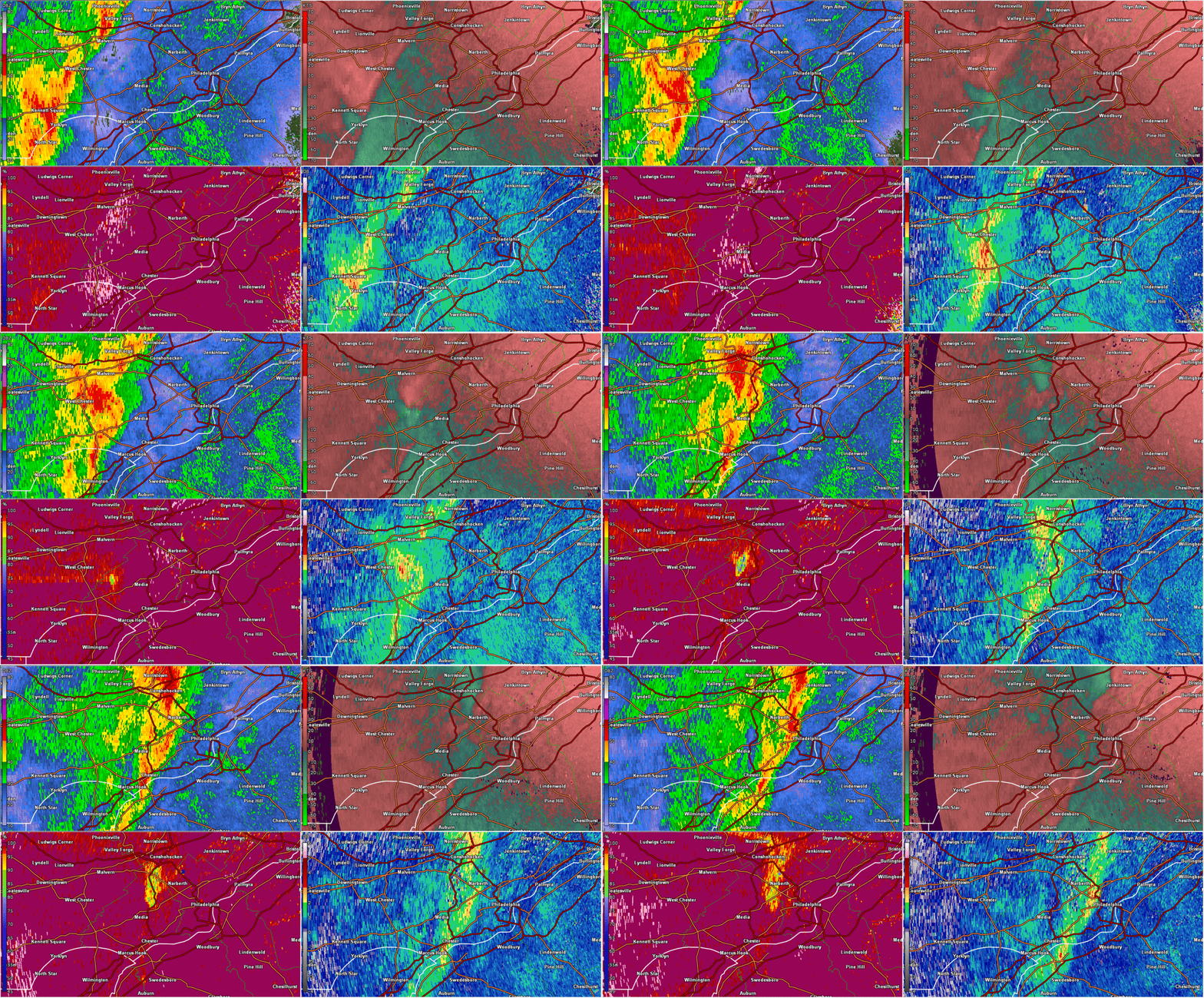 Composite radar loop of the Delaware County Tornado on 31 October 2019. |
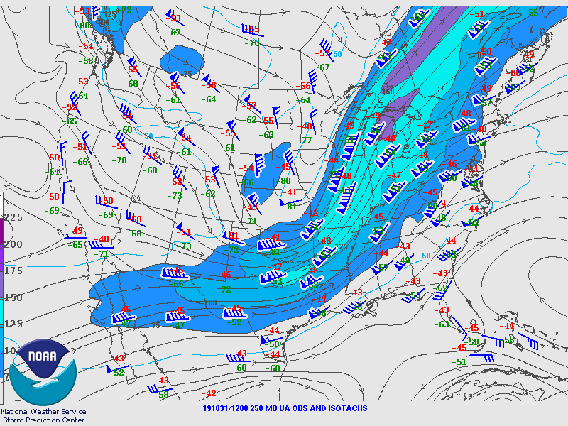
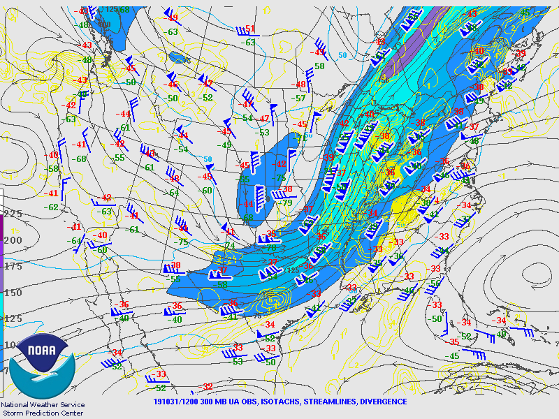
Synoptic Overview at 12z 31 October 2019 (courtesy of SPC)
 |
 |
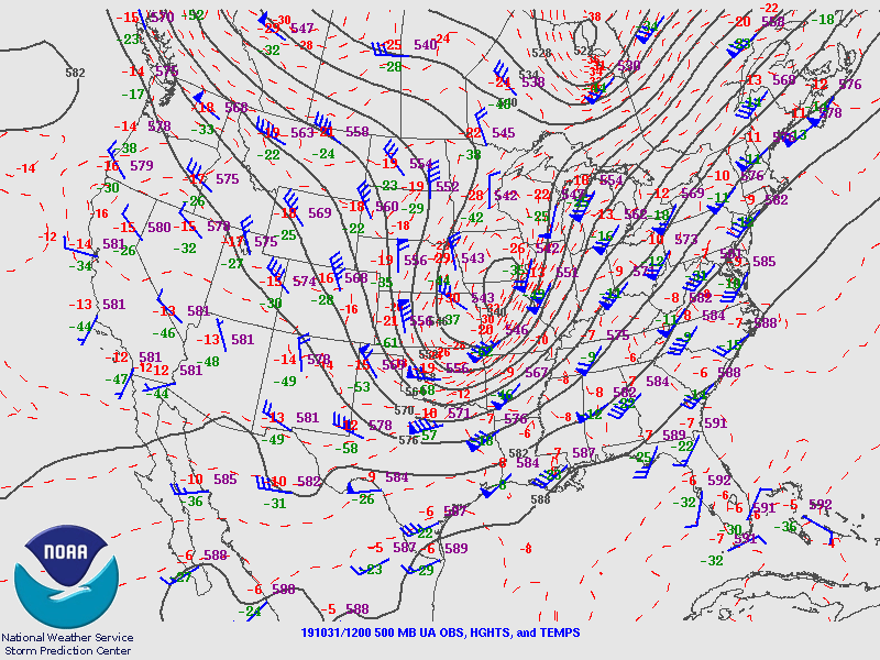 |
| Figure 1: 250-mb analysis | Figure 2: 300-mb analysis | Figure 3: 500-mb analysis |
 |
 |
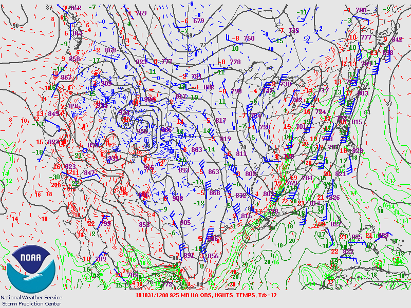 |
| Figure 4: 700-mb analysis | Figure 5: 850-mb analysis | Figure 6: 925-mb analysis |
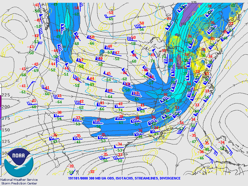
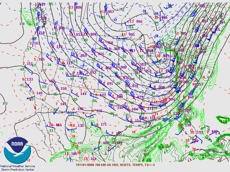
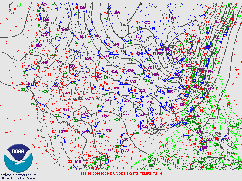
Synoptic Overview at 00z 1 November 2019 (courtesy of SPC)
 |
 |
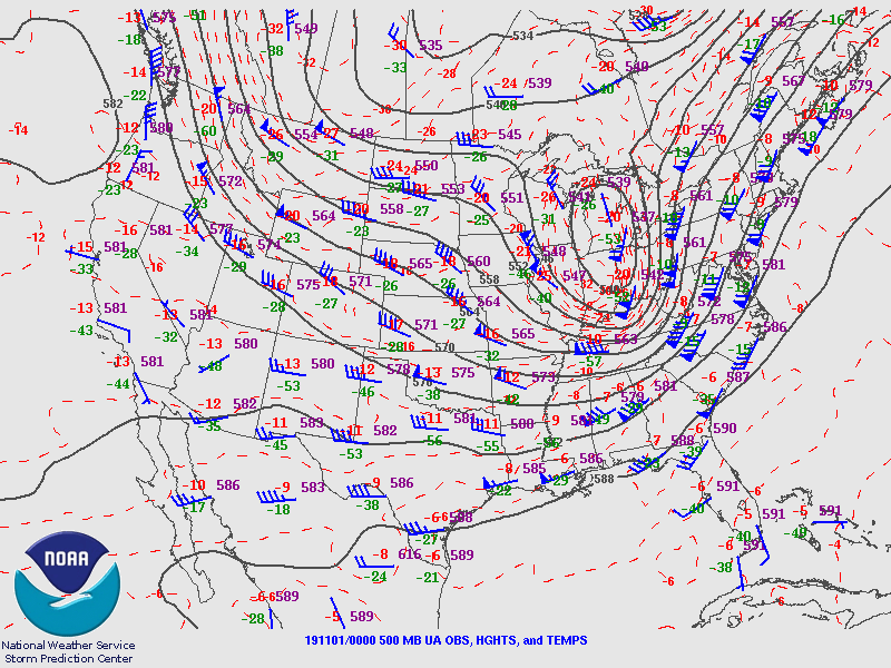 |
| Figure 7: 250-mb analysis | Figure 8: 300-mb analysis | Figure 9: 500-mb analysis |
 |
 |
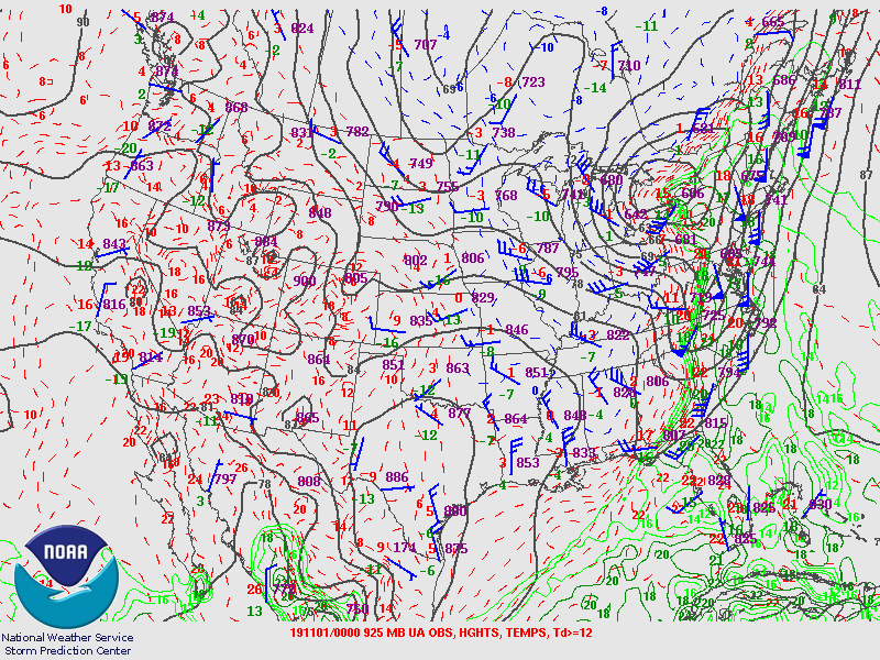 |
| Figure 10: 700-mb analysis | Figure 11: 850-mb analysis | Figure 12: 925-mb analysis |
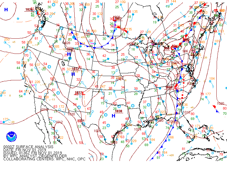
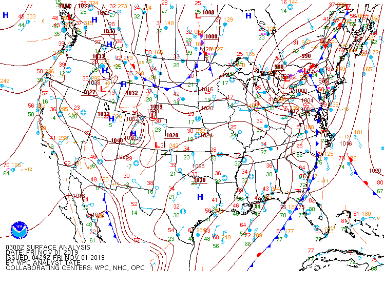
Surface Maps (courtesy of WPC)
 |
 |
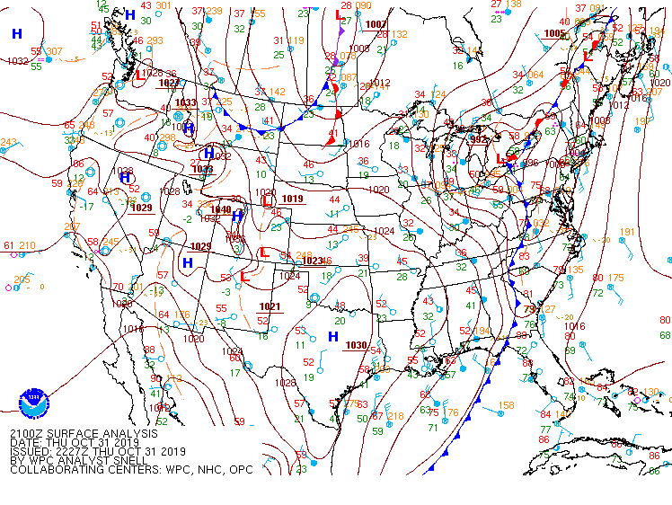 |
| Figure 13: 15z surface map | Figure 14: 18z surface map | Figure 15: 21z surface map |
 |
 |
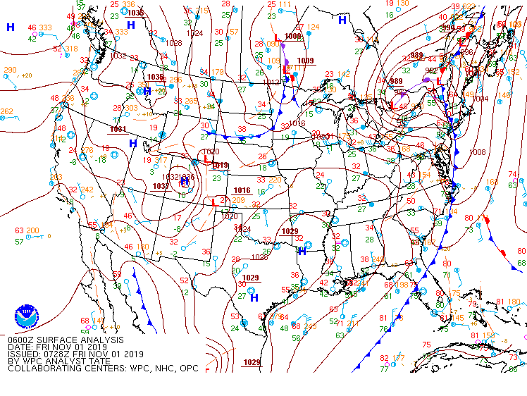 |
| Figure 16: 00z surface map | Figure 17: 03z surface map | Figure 18: 06z surface map |
 |
 |
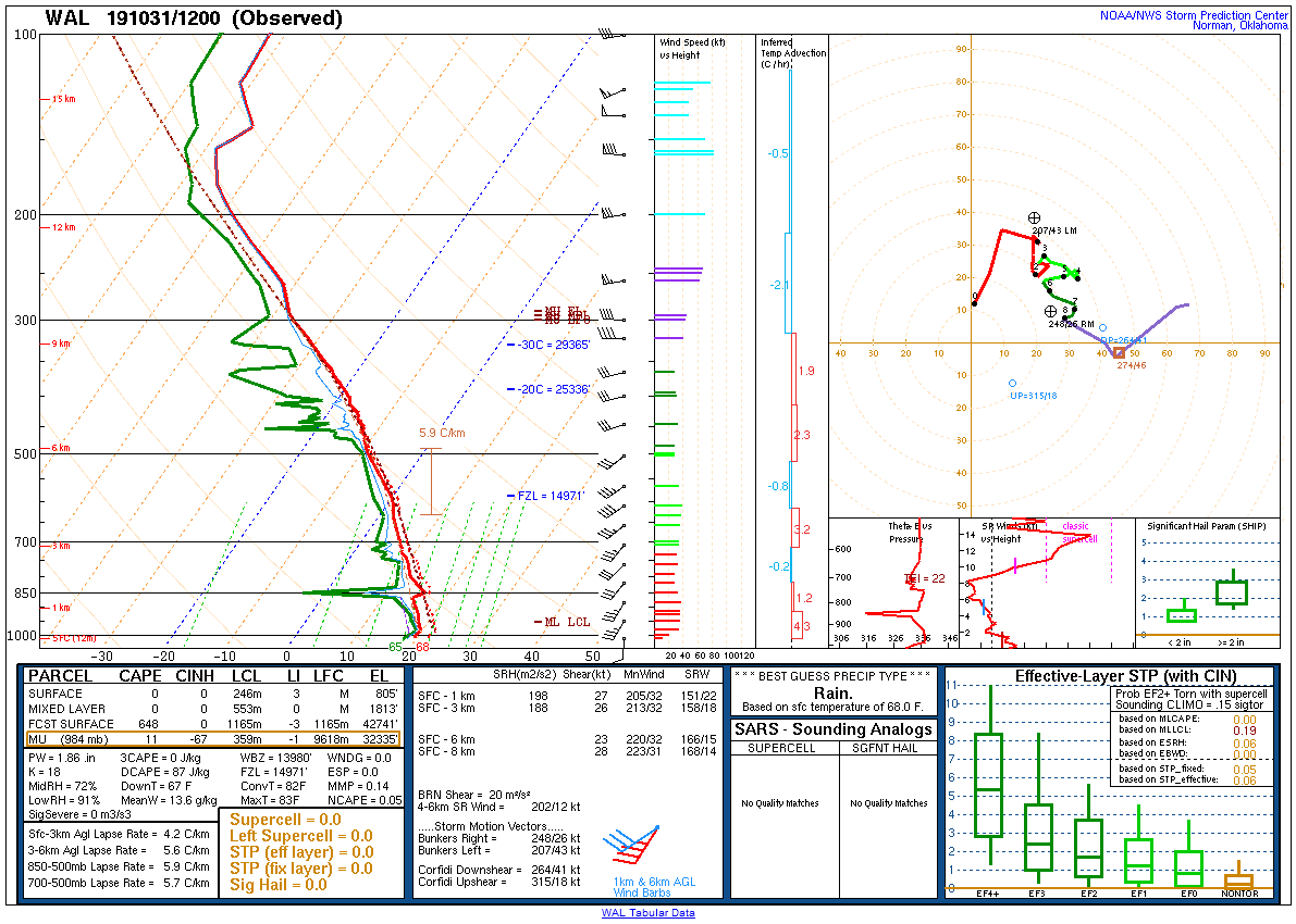 |
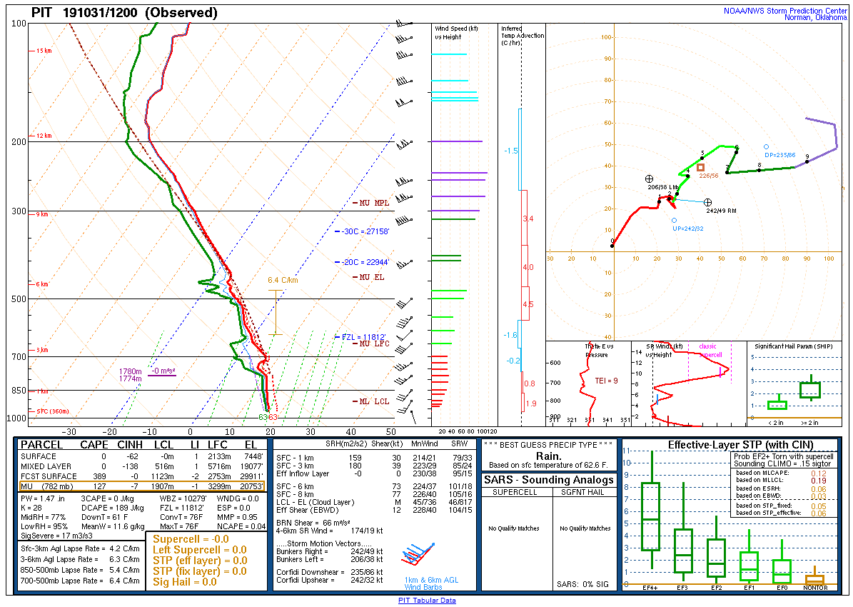
| Figure 19: 12z Pittsburgh, PA sounding | Figure 20: 12z Sterling, VA sounding | Figure 21: 12z Wallops Island, VA sounding |
 |
 |
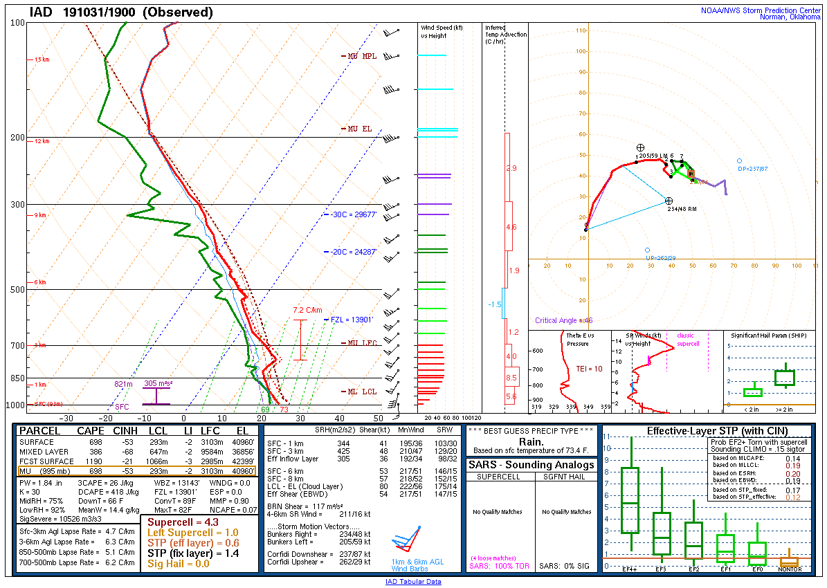 |
| Figure 22: 16z Blacksburg, VA special sounding | Figure 23: 18z Greensboro, NC special sounding | Figure 24: 19z Sterling, VA special sounding |
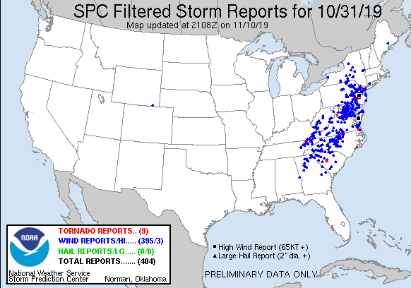 |
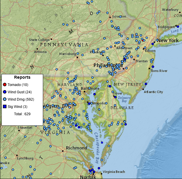 |
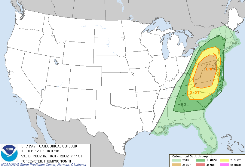 |
| Figure 1: National Preliminary Reports 12z 31 October 2019 to 12z 1 November 2019 | Figure 2: Zoomed Preliminary Reports for the same period. | Figure 3: October 31 1300z SPC Convective Outlook |
Click here for a county warning area based plot of local storm reports and warnings/advisories issued for the 31 October 2019 event.
NWUS51 KPHI 020239
LSRPHI
PRELIMINARY LOCAL STORM REPORT...SUMMARY
NATIONAL WEATHER SERVICE MOUNT HOLLY NJ
1039 PM EDT FRI NOV 1 2019
..TIME... ...EVENT... ...CITY LOCATION... ...LAT.LON...
..DATE... ....MAG.... ..COUNTY LOCATION..ST.. ...SOURCE....
..REMARKS..
0830 PM TSTM WND DMG 2 N MOUNT AETNA 40.45N 76.30W
10/31/2019 BERKS PA UTILITY COMPANY
TREES AND WIRES DOWN NEAR LANCASTER AVENUE.
TIME ESTIMATED FROM RADAR.
0845 PM TSTM WND DMG SUMMIT HILL 40.82N 75.87W
10/31/2019 CARBON PA UTILITY COMPANY
DOWNED TREES AND POWER LINES REPORTED. TIME
ESTIMATED FROM RADAR.
0857 PM TSTM WND DMG BETHEL 40.47N 76.29W
10/31/2019 BERKS PA UTILITY COMPANY
DOWNED TREES AND POWER LINES REPORTED IN THE
AREA. TIME ESTIMATED FROM RADAR.
0859 PM TSTM WND DMG 1 NE MOUNT AETNA 40.43N 76.28W
10/31/2019 BERKS PA FIRE DEPT/RESCUE
DOWNED TREE AND WIRES ON TEMPLE ROAD. TIME
ESTIMATED FROM RADAR.
0909 PM TSTM WND DMG POCONO PINES 41.12N 75.46W
10/31/2019 MONROE PA UTILITY COMPANY
SEVERAL DOWNED TREES AND POWER LINES IN THE
AREA. TIME ESTIMATED FROM RADAR.
0910 PM TSTM WND DMG 3 NW TOBYHANNA TWP 41.16N 75.57W
10/31/2019 MONROE PA UTILITY COMPANY
SEVERAL REPORTS OF DOWNED TREES AND WIRES IN
THE ARROWHEAD LAKE AREA.
0917 PM TSTM WND DMG 1 NW SCOTRUN 41.07N 75.33W
10/31/2019 MONROE PA FIRE DEPT/RESCUE
DOWNED TREE NEAR THE INTERSECTION OF
BROOKDALE ROAD AND FRANTZ HILL ROAD. TIME
ESTIMATED FROM RADAR.
0921 PM TSTM WND DMG 4 NW TOBYHANNA TWP 41.17N 75.59W
10/31/2019 MONROE PA FIRE DEPT/RESCUE
DOWNED TREES AND WIRES ON LOCUST RIDGE ROAD.
TIME ESTIMATED FROM RADAR.
0923 PM TSTM WND DMG SHARTLESVILLE 40.51N 76.11W
10/31/2019 BERKS PA UTILITY COMPANY
DOWNED TREES AND POWER LINES IN THE AREA.
TIME ESTIMATED FROM RADAR.
0926 PM TSTM WND DMG 2 SSW POCONO SUMMIT 41.08N 75.40W
10/31/2019 MONROE PA FIRE DEPT/RESCUE
DOWNED TREE ON ISLAND DRIVE. TIME ESTIMATED
FROM RADAR.
0928 PM TSTM WND DMG 1 NE MOUNT POCONO 41.13N 75.35W
10/31/2019 MONROE PA FIRE DEPT/RESCUE
DOWNED TREE ON SENECA ROAD. TIME ESTIMATED
FROM RADAR.
0943 PM TSTM WND DMG 1 SE BERN TWP 40.38N 75.99W
10/31/2019 BERKS PA FIRE DEPT/RESCUE
DOWNED TREE ON U.S. HIGHWAY 222 NEAR HIGHWAY
183. TIME ESTIMATED FROM RADAR.
0945 PM FLASH FLOOD BETHEL 40.48N 76.29W
10/31/2019 BERKS PA FIRE DEPT/RESCUE
FLASH FLOODING ON WESTBOUND INTERSTATE 78
NEAR MILE MARKER 10 IN BETHEL TWP. CLOSURE
WILL BE REQUIRED.
0952 PM TSTM WND DMG 2 ESE LEESPORT 40.44N 75.94W
10/31/2019 BERKS PA FIRE DEPT/RESCUE
DOWNED TREES AND POWER LINES NEAR WILEYS
ROAD AND PILLAR DRIVE. TIME ESTIMATED FROM
RADAR.
0957 PM TSTM WND DMG BLANDON 40.44N 75.89W
10/31/2019 BERKS PA UTILITY COMPANY
DOWNED TREES AND POWER LINES IN THE AREA.
TIME ESTIMATED FROM RADAR.
1005 PM TSTM WND DMG 1 NE KUTZTOWN 40.53N 75.76W
10/31/2019 BERKS PA PUBLIC
REPORT FROM MPING: 3-INCH TREE LIMBS BROKEN;
POWER POLES BROKEN. TIME ESTIMATED FROM
RADAR.
1006 PM FLASH FLOOD 3 NNW BETHEL 40.51N 76.32W
10/31/2019 BERKS PA FIRE DEPT/RESCUE
MUD AND ROCKS DEPOSITED ON LANCASTER AVENUE,
FORCING ITS CLOSURE.
1010 PM TSTM WND DMG 2 WSW AMITY GARDENS 40.27N 75.76W
10/31/2019 BERKS PA LAW ENFORCEMENT
DOWNED TREE ON HILLVIEW ROAD. TIME ESTIMATED
FROM RADAR.
1014 PM TSTM WND DMG 1 NW UPPER MACUNGIE TWP 40.58N 75.63W
10/31/2019 LEHIGH PA PUBLIC
DOWNED TREES AND SHINGLES BLOWN OFF A HOME.
REPORT VIA SOCIAL MEDIA. TIME ESTIMATED FROM
RADAR.
1016 PM TSTM WND DMG 3 WSW CEDARVILLE 40.21N 75.72W
10/31/2019 CHESTER PA COUNTY OFFICIAL
DOWNED TREE NEAR THE INTERSECTION OF HILL
CAMP ROAD AND CHESTNUT COURT. TIME ESTIMATED
FROM RADAR.
1017 PM TSTM WND DMG 1 SSE EAST NANTMEAL TWP 40.10N 75.71W
10/31/2019 CHESTER PA COUNTY OFFICIAL
DOWNED TREE ON GREENRIDGE ROAD NEAR FONT
ROAD. TIME ESTIMATED FROM RADAR.
1023 PM TSTM WND DMG 2 SW EAST BRANDYWINE TW 40.02N 75.79W
10/31/2019 CHESTER PA COUNTY OFFICIAL
LARGE TREE DOWN NEAR THE INTERSECTION OF
REECEVILLE ROAD AND CALN MEETINGHOUSE ROAD.
TIME ESTIMATED FROM RADAR.
1028 PM TSTM WND DMG 1 ESE ALLEN TWP 40.69N 75.45W
10/31/2019 NORTHAMPTON PA NEWSPAPER
DOWNED TREES AND WIRES ON WEAVERSVILLE ROAD.
TIME ESTIMATED FROM RADAR.
1032 PM TSTM WND DMG SCIOTA 40.94N 75.31W
10/31/2019 MONROE PA DEPT OF HIGHWAYS
DOWNED TREE NEAR THE INTERSECTION OF ROUTE
209 AND NEOLA ROAD. TIME ESTIMATED FROM
RADAR.
1034 PM TSTM WND DMG 1 NNW HANOVER TWP 40.69N 75.39W
10/31/2019 NORTHAMPTON PA DEPT OF HIGHWAYS
DOWNED UTILITY ON STATE HIGHWAY 512 NEAR
JAINDL BOULEVARD. TIME ESTIMATED FROM RADAR.
1036 PM FLOOD 2 E LAKE HARMONY 41.06N 75.55W
10/31/2019 MONROE PA FIRE DEPT/RESCUE
FLOODING REPORTED ON STATE HIGHWAY 115 NEAR
STATE HIGHWAY 903.
1039 PM TSTM WND DMG 2 ENE STEUBEN 40.70N 75.33W
10/31/2019 NORTHAMPTON PA DEPT OF HIGHWAYS
DOWNED TREE AND WIRES NEAR THE INTERSECTION
OF NEWBURG ROAD AND NAZARETH-BETHLEHEM PIKE.
TIME ESTIMATED FROM RADAR.
1044 PM FLASH FLOOD LEESPORT 40.45N 75.97W
10/31/2019 BERKS PA FIRE DEPT/RESCUE
NORTH CENTRE AVENUE CLOSED FROM FLASH
FLOODING.
1046 PM TSTM WND DMG 1 WNW ROSETO 40.89N 75.23W
10/31/2019 NORTHAMPTON PA DEPT OF HIGHWAYS
DOWNED UTILITY NEAR THE INTERSECTION OF
BANGOR ROAD AND GARIBALDI AVENUE. TIME
ESTIMATED FROM RADAR.
1106 PM TSTM WND GST 5 N ROCK HALL 39.21N 76.24W
10/31/2019 M61 MPH KENT MD MESONET
TOLCHESTER BEACH NOS GAUGE.
1109 PM TSTM WND DMG 1 NE UWCHLAN TWP 40.06N 75.61W
10/31/2019 CHESTER PA PUBLIC
REPORT FROM MPING: 1-INCH TREE LIMBS BROKEN;
SHINGLES BLOWN OFF. TIME ESTIMATED FROM
RADAR.
1111 PM TSTM WND DMG 4 WSW CHESTER 38.95N 76.35W
10/31/2019 QUEEN ANNE'S MD DEPT OF HIGHWAYS
DOWNED UTILITY NEAR THE INTERSECTION OF
STATE HIGHWAY 802 AND ROMANCOKE ROAD. TIME
ESTIMATED FROM RADAR.
1115 PM FLASH FLOOD EAST STROUDSBURG 40.99N 75.18W
10/31/2019 MONROE PA FIRE DEPT/RESCUE
WATER RESCUE IN PROGRESS ON LINCOLN AVENUE.
1116 PM TSTM WND DMG 2 NE KENNETT SQUARE 39.86N 75.69W
10/31/2019 CHESTER PA DEPT OF HIGHWAYS
DOWNED TREE ON U.S. HIGHWAY 1 NEAR SCHOOL
HOUSE ROAD. TIME ESTIMATED FROM RADAR.
1119 PM TSTM WND DMG 1 E PHILLIPSBURG 40.70N 75.18W
10/31/2019 WARREN NJ COUNTY OFFICIAL
SEVERAL REPORTS OF DOWNED TREES AND POWER
LINES IN PHILLIPSBURG AND LOPATCONG TWP.
TIME ESTIMATED FROM RADAR.
1119 PM TSTM WND DMG 2 SSW GLASGOW 39.58N 75.76W
10/31/2019 NEW CASTLE DE DEPT OF HIGHWAYS
DOWNED TREE AND WIRES NEAR THE INTERSECTION
OF OLD COUNTY ROAD AND FARMINGTON AVENUE.
TIME ESTIMATED FROM RADAR.
1119 PM TSTM WND DMG 1 W WINTERTHUR 39.81N 75.64W
10/31/2019 NEW CASTLE DE DEPT OF HIGHWAYS
DOWNED POWER LINES ON WAY ROAD BETWEEN OLD
KENNETT ROAD AND CREEK ROAD. TIME ESTIMATED
FROM RADAR.
1121 PM TSTM WND DMG 2 S WESTTOWN 39.91N 75.55W
10/31/2019 DELAWARE PA DEPT OF HIGHWAYS
DOWNED TREE ON DILWORTHTOWN ROAD NEAR BINTON
LAKE ROAD. TIME ESTIMATED FROM RADAR.
1124 PM TSTM WND DMG 1 ENE WESTTOWN 39.94N 75.54W
10/31/2019 CHESTER PA DEPT OF HIGHWAYS
DOWNED TREE NEAR THE INTERSECTION OF ROUTE
926 AND WESTTOWN ROAD. TIME ESTIMATED FROM
RADAR.
1124 PM TSTM WND DMG 1 NNW WEST GOSHEN 39.98N 75.58W
10/31/2019 CHESTER PA DEPT OF HIGHWAYS
DOWNED TREE ON FERN HILL ROAD. TIME
ESTIMATED FROM RADAR.
1125 PM TORNADO GLEN MILLS 39.92N 75.52W
10/31/2019 DELAWARE PA NWS STORM SURVEY
*** 2 INJ ***
A TORNADO EMBEDDED IN A LARGER AREA OF
STRAIGHT LINE WINDS TOUCHED DOWN JUST
SOUTHWEST OF THE COBBLESTONE AT THORNBURY
SUBDIVISION IN THE TOWN OF GLEN MILLS,
DELAWARE COUNTY AT 11:25 PM EDT, THURSDAY,
OCTOBER 31, 2019. DAMAGE NEAR THE BEGINNING
OF THE TORNADO PATH ALONG CHENEY ROAD
CONSISTED OF A FEW SPORADIC UPROOTED TREES
AND ASSOCIATED COLLATERAL DAMAGE OF ADJACENT
HOMES. HOWEVER, AS THE TORNADO REACHED ITS
MAXIMUM EF2 STRENGTH, THE NUMBER AND SIZE OF
UPROOTED TREES INCREASED WITH SIGNIFICANT
ASSOCIATED DAMAGE TO NEARBY HOMES. THREE
HOUSES SUSTAINED SIGNIFICANT DAMAGE FROM THE
WIND ITSELF, WHICH, BASED ON THIS SURVEY,
PEAKED AROUND 120 MPH. AS THE EF2 TORNADO
CONTINUED TO MOVE NORTHEAST, AT LEAST TWO
GREENHOUSES WERE DESTROYED BEFORE IT LIFTED
NEAR THE INTERSECTION OF ORCHARD AND
BROOMALL LANES. HOWEVER, SIGNIFICANT
STRAIGHT LINE WIND DAMAGE CONTINUED BEYOND
THIS INTERSECTION WITH DOZENS OF SNAPPED AND
UPROOTED TREES, ESPECIALLY WITHIN THE GOLF
COURSE AT GLEN MILLS, BEFORE THE STRONG
WINDS GRADUALLY WEAKENED BELOW SEVERE
LIMITS. THE NWS SURVEY TEAM WOULD LIKE TO
THANK DELAWARE COUNTY EMERGENCY MANAGEMENT
FOR THEIR ASSISTANCE WITH THIS SURVEY.
1125 PM HEAVY RAIN TOBYHANNA 41.18N 75.42W
10/31/2019 M3.09 INCH MONROE PA TRAINED SPOTTER
STORM TOTAL FROM 800 AM TO 1125 PM.
1127 PM TSTM WND DMG HENRY CLAY 39.77N 75.58W
10/31/2019 NEW CASTLE DE DEPT OF HIGHWAYS
DOWNED TREE ON NEW BRIDGE ROAD BETWEEN ROUTE
141 AND RISING SUN LANE. TIME ESTIMATED FROM
RADAR.
1127 PM TSTM WND DMG GREENVILLE MANOR 39.78N 75.59W
10/31/2019 NEW CASTLE DE DEPT OF HIGHWAYS
DOWNED TREE NEAR THE INTERSECTION OF
MONTCHANIN ROAD AND BUCK ROAD. TIME
ESTIMATED FROM RADAR.
1127 PM TSTM WND DMG 1 WNW TALLEYVILLE 39.82N 75.57W
10/31/2019 NEW CASTLE DE DEPT OF HIGHWAYS
DOWNED TREE ON THOMPSONS BRIDGE ROAD BETWEEN
GUYENCOURT ROAD AND WOODLAWN ROAD. TIME
ESTIMATED FROM RADAR.
1128 PM TSTM WND DMG MIDDLETOWN 39.45N 75.72W
10/31/2019 NEW CASTLE DE PUBLIC
TREES DOWN, HOMES DAMAGED. TIME ESTIMATED
FROM RADAR.
1129 PM TSTM WND DMG KINTNERSVILLE 40.56N 75.18W
10/31/2019 BUCKS PA DEPT OF HIGHWAYS
DOWNED TREE ON STATE HIGHWAY 611 NEAR
KINTNER ROAD. TIME ESTIMATED FROM RADAR.
1129 PM TSTM WND DMG POHATCONG TWP 40.65N 75.14W
10/31/2019 WARREN NJ COUNTY OFFICIAL
TREES AND WIRES DOWN ON PINCHERS POINT ROAD,
RIVER ROAD, EDGE ROAD, AND STILL VALLEY
ROAD. TIME ESTIMATED FROM RADAR.
1130 PM TSTM WND DMG 2 NE EDGMONT TWP 39.97N 75.44W
10/31/2019 DELAWARE PA PUBLIC
SEVERAL LARGE TREES AND LIMBS DOWNED NEAR
PROVIDENCE ROAD. TIME ESTIMATED FROM RADAR.
1130 PM FLASH FLOOD 1 S BETHLEHEM TWP 40.65N 75.33W
10/31/2019 NORTHAMPTON PA FIRE DEPT/RESCUE
WILLOW PARK ROAD CLOSED FROM FLASH FLOODING.
1131 PM FLASH FLOOD 1 ESE ALLENTOWN 40.60N 75.46W
10/31/2019 LEHIGH PA FIRE DEPT/RESCUE
WATER RESCUE IN PROGRESS ON BASIN STREET.
1132 PM TSTM WND DMG 1 SE BERWYN 40.04N 75.42W
10/31/2019 CHESTER PA PUBLIC
DOWNED TREE AND WIRES NEAR THE INTERSECTION
OF SUGARTOWN ROAD AND FAIRFIELD ROAD. TIME
ESTIMATED FROM RADAR.
1132 PM TSTM WND DMG 1 W GARDENDALE 39.84N 75.46W
10/31/2019 DELAWARE PA TRAINED SPOTTER
LARGE TREE DOWN ON BENNETT LANE. TIME
ESTIMATED FROM RADAR.
1132 PM TSTM WND DMG 1 SE NEWTOWN SQUARE 39.98N 75.40W
10/31/2019 DELAWARE PA PUBLIC
REPORT FROM MPING: 3-INCH TREE LIMBS BROKEN;
POWER POLES BROKEN.
1134 PM TSTM WND DMG 1 N SPRINGFIELD 39.95N 75.32W
10/31/2019 DELAWARE PA PUBLIC
LARGE HARDWOOD TREE FELLED ONTO A PARKED
MINIVAN. TIME ESTIMATED FROM RADAR.
1134 PM TSTM WND DMG BROOMALL 39.98N 75.36W
10/31/2019 DELAWARE PA PUBLIC
REPORT FROM MPING: 3-INCH TREE LIMBS BROKEN;
POWER POLES BROKEN. TIME ESTIMATED FROM
RADAR.
1134 PM TSTM WND DMG 1 SE VILLANOVA 40.02N 75.34W
10/31/2019 DELAWARE PA PUBLIC
SEVERAL LARGE TREE LIMBS DOWN, DAMAGING A
HOME. TIME ESTIMATED FROM RADAR.
1134 PM TSTM WND DMG 1 NW WAYNE 40.06N 75.38W
10/31/2019 CHESTER PA PUBLIC
MULTIPLE TREES SNAPPED WITH LARGE LIMBS DOWN
AT ST. DAVIDS GOLF CLUB IN WAYNE. TIME
ESTIMATED FROM RADAR.
1135 PM TSTM WND GST 1 S ODESSA 39.44N 75.66W
10/31/2019 M62 MPH NEW CASTLE DE MESONET
DEDOT GAUGE.
1137 PM FLASH FLOOD 1 WSW POCONO SUMMIT 41.10N 75.41W
10/31/2019 MONROE PA FIRE DEPT/RESCUE
LONG POND ROAD CLOSED FROM FLASH FLOODING.
1137 PM TSTM WND DMG OXFORD 40.81N 75.00W
10/31/2019 WARREN NJ COUNTY OFFICIAL
SEVERAL REPORTS OF DOWNED TREES IN OXFORD
TWP, INCLUDING ON JONESTOWN ROAD AND
WASHINGTON AVENUE. TIME ESTIMATED FROM
RADAR.
1137 PM TSTM WND DMG 1 WSW WEST CONSHOHOCKEN 40.06N 75.32W
10/31/2019 MONTGOMERY PA DEPT OF HIGHWAYS
DOWNED TREE NEAR THE INTERSTATE 76 AND 476
INTERCHANGE. TIME ESTIMATED FROM RADAR.
1142 PM TSTM WND DMG AMBLER 40.16N 75.22W
10/31/2019 MONTGOMERY PA EMERGENCY MNGR
*** 1 INJ ***
A HOUSE COLLAPSE OCCURRED AS A RESULT OF
STRONG WIND GUSTS. ONE INJURY WAS REPORTED.
TIME ESTIMATED FROM RADAR.
1142 PM TSTM WND DMG FLOURTOWN 40.10N 75.21W
10/31/2019 MONTGOMERY PA PUBLIC
DOWNED TREES REPORTED. TIME ESTIMATED FROM
RADAR.
1142 PM TSTM WND DMG 1 NNW CHESTNUT HILL 40.09N 75.21W
10/31/2019 PHILADELPHIA PA DEPT OF HIGHWAYS
DOWNED UTILITY NEAR THE INTERSECTION OF
STENTON AVENUE AND HILLCREST AVENUE. TIME
ESTIMATED FROM RADAR.
1144 PM TSTM WND DMG UPPER DUBLIN TWP 40.16N 75.20W
10/31/2019 MONTGOMERY PA DEPT OF HIGHWAYS
DOWNED TREE ON STATE HIGHWAY 309 NEAR
LINCOLN DRIVE. TIME ESTIMATED FROM RADAR.
1145 PM TSTM WND GST 1 NNW WARMINSTER 40.22N 75.11W
10/31/2019 E110 MPH BUCKS PA NWS STORM SURVEY
*** 2 INJ ***
A NATIONAL WEATHER SERVICE SURVEY TEAM
DETERMINED THAT STRAIGHT LINE WINDS WERE THE
CAUSE OF TREE, UTILITY, AND COLLATERAL
STRUCTURAL DAMAGE IN THE VICINITY OF
HARTSVILLE, WARMINSTER TOWNSHIP, BUCKS
COUNTY, PENNSYLVANIA ON OCTOBER 31, 2019.
MULTIPLE HOMES SUSTAINED DAMAGE FROM FALLING
TREES ON AND NEAR BARNESS DR, AND SEVERAL
UTILITY POLES WERE SNAPPED NEAR THEIR BASE
ALONG STREET RD. WIND GUSTS UP TO 110 MPH
WERE RESPONSIBLE FOR THIS DAMAGE ALONG A
SPORADIC AND NON-CONTINUOUS PATH, ALTHOUGH
MOST AREAS EXPERIENCED WINDS OF LESSER
MAGNITUDE. THE NWS SURVEY TEAM WOULD LIKE TO
THANK BUCKS COUNTY EMERGENCY SERVICES AND
THE HARTSVILLE FIRE DEPARTMENT FOR THEIR
ASSISTANCE WITH THIS SURVEY.
1145 PM TSTM WND DMG BUCKINGHAM TWP 40.33N 75.06W
10/31/2019 BUCKS PA EMERGENCY MNGR
NUMEROUS TREES DOWN ACROSS BUCKINGHAM TWP.
ROAD CLOSURES INCLUDE PINEVILLE RD BETWEEN
NEW RD & NEW HOPE RD; PINEVILLE RD BETWEEN
STREET RD & STONY HILL RD; SUGAR BOTTOM RD
AT LOWER MOUNTAIN RD; UPPER MOUNTAIN RD
BETWEEN QUARRY RD & RT413; ASH MILL RD
BETWEEN RT202 & MECHANICSVILLE RD. TIME
ESTIMATED FROM RADAR.
1147 PM TSTM WND DMG HATBORO 40.17N 75.11W
10/31/2019 MONTGOMERY PA NWS EMPLOYEE
CORRECTS PREVIOUS TSTM WND DMG REPORT FROM
HATBORO. SEVERAL REPORTS OF TREES AND POWER
LINES DOWN AS WELL AS DAMAGE TO RESIDENTIAL
FENCES, SHINGLES, AND SIDING IN HATBORO,
HORSHAM, AND WILLOW GROVE. TIME ESTIMATED
FROM RADAR.
1147 PM TSTM WND DMG EASTON 38.77N 76.07W
10/31/2019 TALBOT MD EMERGENCY MNGR
SEVERAL REPORTS OF DOWNED TREES IN THE AREA.
TIME ESTIMATED FROM RADAR.
1147 PM TSTM WND DMG 3 NE HORSHAM TWP 40.23N 75.14W
10/31/2019 BUCKS PA EMERGENCY MNGR
SIGNIFICANT DAMAGE IN THE AREA OF STREET
ROAD, COUNTY LINE ROAD, AND STATE HIGHWAY
611. SEVERAL UTILITY POLES WERE BLOWN DOWN.
NUMEROUS TREES AND POWER LINES DOWN ACROSS
THE AREA. TIME ESTIMATED FROM RADAR.
1148 PM TSTM WND DMG 2 SSE DOYLESTOWN 40.29N 75.12W
10/31/2019 BUCKS PA TRAINED SPOTTER
SEVERAL TREES UPROOTED IN THE PEBBLE WOODS
NEIGHBORHOOD. TIME ESTIMATED FROM RADAR.
1149 PM TSTM WND DMG WARMINSTER 40.21N 75.10W
10/31/2019 BUCKS PA EMERGENCY MNGR
A TREE FELL ONTO AND DESTROYED A HOUSE. NO
INJURIES REPORTED.
1149 PM TSTM WND DMG 2 SE SMYRNA LANDING 39.28N 75.56W
10/31/2019 KENT DE DEPT OF HIGHWAYS
DOWNED TREE ON SMYRNA LEIPSIC ROAD BETWEEN
BIG OAK ROAD AND HURD ROAD. TIME ESTIMATED
FROM RADAR.
1149 PM TSTM WND DMG ALLAMUCHY-PANTHER VALLE 40.91N 74.83W
10/31/2019 WARREN NJ COUNTY OFFICIAL
SEVERAL REPORTS OF DOWNED TREES AND POWER
LINES IN ALLAMUCHY TWP AND HACKETTSTOWN.
TIME ESTIMATED FROM RADAR.
1150 PM TSTM WND DMG 1 NNW HACKETTSTOWN 40.86N 74.83W
10/31/2019 WARREN NJ BROADCAST MEDIA
LARGE TREE DOWN ON POWER LINES ON HAMILTON
DR. TIME ESTIMATED FROM RADAR.
1152 PM TSTM WND DMG STOCKTON 40.40N 74.97W
10/31/2019 HUNTERDON NJ DEPT OF HIGHWAYS
DOWNED POWER LINES ON STATE HIGHWAY 29 SOUTH
OF FERRY STREET. ALL LANES CLOSED.
1152 PM TSTM WND DMG SOLEBURY TWP 40.38N 75.01W
10/31/2019 BUCKS PA DEPT OF HIGHWAYS
DOWNED TREE AND WIRES NEAR THE INTERSECTION
OF SUGAN ROAD AND PHILLIPS MILL ROAD. TIME
ESTIMATED FROM RADAR.
1152 PM TSTM WND DMG 1 SSE SERGEANTSVILLE 40.43N 74.94W
10/31/2019 HUNTERDON NJ EMERGENCY MNGR
*** 1 INJ ***
LARGE TREE FELL ONTO A HOUSE. ONE SERIOUS
INJURY REPORTED.
1154 PM TSTM WND DMG 2 S GREENSBORO 38.95N 75.81W
10/31/2019 CAROLINE MD PUBLIC
DOWNED POWER LINES NEAR THE INTERSECTION OF
SPRING BRANCH ROAD AND GREENSBORO ROAD. TIME
ESTIMATED FROM RADAR.
1154 PM TSTM WND DMG HOPATCONG 40.94N 74.67W
10/31/2019 SUSSEX NJ PUBLIC
PHOTO SHOWING A LARGE TREE DOWN ON POWER
LINES. REPORT INDICATES SEVERAL ADDITIONAL
TREES ARE DOWN ON POWER LINES WITH SOME
TRANSFORMER FIRES IN THE AREA. TIME
ESTIMATED FROM RADAR.
1154 PM TSTM WND DMG 1 SE STOCKTON 40.40N 74.96W
10/31/2019 HUNTERDON NJ DEPT OF HIGHWAYS
DOWNED TREE ON STATE HIGHWAY 29 SOUTH OF
BROOKVILLE HOLLOW ROAD. ALL LANES CLOSED.
TIME ESTIMATED FROM RADAR.
1154 PM TSTM WND DMG 1 SW WRIGHTSTOWN TWP 40.26N 75.01W
10/31/2019 BUCKS PA DEPT OF HIGHWAYS
DOWNED TREE ON SWAMP ROAD NEAR SECOND STREET
PIKE. TIME ESTIMATED FROM RADAR.
1155 PM FLOOD 1 SW KING OF PRUSSIA 40.08N 75.39W
10/31/2019 MONTGOMERY PA DEPT OF HIGHWAYS
LANE RESTRICTIONS ON INTERSTATE 76 NEAR EXIT
330 FROM FLOODING.
1157 PM TSTM WND DMG 1 N MERCHANTVILLE 39.97N 75.05W
10/31/2019 CAMDEN NJ DEPT OF HIGHWAYS
DOWNED POWER LINES ON U.S. HIGHWAY 130
SOUTHBOUND SOUTH OF UNION AVENUE. LANE
RESTRICTIONS IN PLACE. TIME ESTIMATED FROM
RADAR.
1200 AM TSTM WND DMG WASHINGTON CROSSING 40.29N 74.86W
11/01/2019 MERCER NJ DEPT OF HIGHWAYS
DOWNED TREE ON STATE HIGHWAY 29 BETWEEN
WASHINGTON CROSSING ROAD AND VALLEY ROAD.
ALL LANES CLOSED. TIME ESTIMATED FROM RADAR.
1200 AM TSTM WND DMG 1 N FLANDERS 40.86N 74.70W
11/01/2019 MORRIS NJ DEPT OF HIGHWAYS
DOWNED TREE ON U.S. HIGHWAY 206 NORTH OF
FLANDERS NETCONG ROAD. ALL LANES CLOSED.
TIME ESTIMATED FROM RADAR.
1200 AM FLASH FLOOD 2 ENE STEUBEN 40.70N 75.33W
11/01/2019 NORTHAMPTON PA NEWSPAPER
FLASH FLOODING ON NEWBURG ROAD NEAR ROUTE
191 WITH ROADS CLOSED.
1201 AM FLOOD 2 WNW SCHOOLEYS MOUNTAI 40.81N 74.84W
11/01/2019 WARREN NJ COUNTY OFFICIAL
STREET FLOODING ON KINGS HIGHWAY AND ROUTE
57.
1202 AM TSTM WND GST 3 SSW LITTLE CREEK 39.13N 75.47W
11/01/2019 M59 MPH KENT DE AWOS
1205 AM TSTM WND DMG 1 ESE SUCCASUNNA 40.86N 74.63W
11/01/2019 MORRIS NJ DEPT OF HIGHWAYS
DOWNED TREE ON STATE HIGHWAY 10 EASTBOUND
NEAR COUNTY ROAD 617. ALL LANES CLOSED. TIME
ESTIMATED FROM RADAR.
1205 AM TSTM WND DMG 2 N GLADSTONE 40.75N 74.67W
11/01/2019 MORRIS NJ PUBLIC
REPORT FROM MPING: 3-INCH TREE LIMBS BROKEN;
POWER POLES BROKEN. TIME ESTIMATED FROM
RADAR.
1210 AM TSTM WND DMG 1 W HARDYSTON TWP 41.11N 74.55W
11/01/2019 SUSSEX NJ DEPT OF HIGHWAYS
DOWNED TREE ON STATE HIGHWAY 23 SOUTH OF
BEAVER LAKE ROAD. ALL LANES CLOSED. TIME
ESTIMATED FROM RADAR.
1214 AM TSTM WND DMG 1 ENE HILLSBOROUGH TWP 40.51N 74.67W
11/01/2019 SOMERSET NJ EMERGENCY MNGR
EMERGENCY MANAGEMENT REPORTS NUMEROUS TREES
UPROOTED THROUGHOUT HILLSBOROUGH TWP. TIME
ESTIMATED FROM RADAR.
1215 AM TSTM WND DMG 1 W MANVILLE 40.55N 74.61W
11/01/2019 SOMERSET NJ DEPT OF HIGHWAYS
DOWNED TREE AND WIRES ON U.S. HIGHWAY 206
SOUTHBOUND SOUTH OF DUKES PARKWAY WEST. LANE
RESTRICTIONS IN PLACE. TIME ESTIMATED FROM
RADAR.
1215 AM TSTM WND DMG 1 WSW BERNARDS TWP 40.69N 74.57W
11/01/2019 SOMERSET NJ DEPT OF HIGHWAYS
DOWNED TREE ON INTERSTATE 287 NORTHBOUND
NORTH OF EXIT 26. LANE CLOSURES IN PLACE.
TIME ESTIMATED FROM RADAR.
1215 AM TSTM WND DMG ROCKAWAY 40.90N 74.51W
11/01/2019 MORRIS NJ PUBLIC
REPORT FROM MPING: 1-INCH TREE LIMBS BROKEN;
SHINGLES BLOWN OFF.
1215 AM FLASH FLOOD 1 SSE COOPERSBURG 40.49N 75.38W
11/01/2019 BUCKS PA EMERGENCY MNGR
FLASH FLOODING CLOSED PORTIONS OF STATE
HIGHWAY 309 IN SPRINGFIELD TWP.
1218 AM TSTM WND DMG 1 ENE BERNARDSVILLE 40.72N 74.56W
11/01/2019 SOMERSET NJ DEPT OF HIGHWAYS
DOWNED TREE ON U.S. HIGHWAY 202 NORTH OF
FINNEY AVENUE. ALL LANES CLOSED. TIME
ESTIMATED FROM RADAR.
1218 AM TSTM WND DMG PRINCETON JUNCTION 40.32N 74.62W
11/01/2019 MERCER NJ DEPT OF HIGHWAYS
DOWNED TREE ON STATE HIGHWAY 64 SOUTHBOUND
NEAR CRANBURY ROAD. ALL LANES CLOSED. TIME
ESTIMATED FROM RADAR.
1220 AM TSTM WND DMG 2 SSE HOUSTON 38.89N 75.48W
11/01/2019 SUSSEX DE PUBLIC
SEVERAL TREES SNAPPED NEAR A RESIDENCE. TIME
ESTIMATED FROM RADAR.
1223 AM TSTM WND DMG 1 NE MORRISTOWN 40.80N 74.47W
11/01/2019 MORRIS NJ PUBLIC
REPORT FROM MPING: 1-INCH TREE LIMBS BROKEN;
SHINGLES BLOWN OFF. TIME ESTIMATED FROM
RADAR.
1225 AM FLASH FLOOD 1 E PHILLIPSBURG 40.70N 75.18W
11/01/2019 WARREN NJ COUNTY OFFICIAL
WATER SEVERAL FEET DEEP ON ROSEBERRY STREET.
1228 AM TSTM WND DMG 1 E MADISON 40.76N 74.39W
11/01/2019 MORRIS NJ DEPT OF HIGHWAYS
DOWNED TREE ON STATE HIGHWAY 24 WEST OF EXIT
7. LANE RESTRICTIONS IN PLACE. TIME
ESTIMATED FROM RADAR.
1235 AM TSTM WND DMG 1 ENE METUCHEN 40.55N 74.36W
11/01/2019 MIDDLESEX NJ DEPT OF HIGHWAYS
DOWNED POWER LINES ON STATE HIGHWAY 27 SOUTH
OF GROVE AVENUE. ALL LANES CLOSED. TIME
ESTIMATED FROM RADAR.
1241 AM FLASH FLOOD 2 E PHILLIPSBURG 40.70N 75.16W
11/01/2019 WARREN NJ DEPT OF HIGHWAYS
FLASH FLOODING HAS CLOSED U.S. HIGHWAY 22
EASTBOUND NEAR STATE HIGHWAY 57.
1242 AM FLOOD 1 SE COLUMBIA 40.92N 75.08W
11/01/2019 WARREN NJ COUNTY OFFICIAL
FLOODING ON ROUTE 46 AND WALNUT ROAD.
0106 AM TSTM WND DMG 2 NE RAMTOWN 40.14N 74.11W
11/01/2019 MONMOUTH NJ DEPT OF HIGHWAYS
DOWNED TREE ON GARDEN STATE PARKWAY
SOUTHBOUND SOUTH OF EXIT 98. LANE
RESTRICTIONS IN PLACE. TIME ESTIMATED FROM
RADAR.
0106 AM TSTM WND DMG 3 ESE FARMINGDALE 40.19N 74.12W
11/01/2019 MONMOUTH NJ DEPT OF HIGHWAYS
DOWNED TREES AND WIRES ON STATE HIGHWAY 34
SOUTH OF MONMOUTH EXECUTIVE AIRPORT. ALL
LANES CLOSED. TIME ESTIMATED FROM RADAR.
0107 AM FLOOD 1 SW KING OF PRUSSIA 40.08N 75.39W
11/01/2019 MONTGOMERY PA DEPT OF HIGHWAYS
FLOODING ON U.S. HIGHWAY 202 NEAR THE
INTERSTATE 76 INTERCHANGE. LANE RESTRICTIONS
IN PLACE.
0108 AM TSTM WND DMG 2 WNW NEPTUNE CITY 40.21N 74.07W
11/01/2019 MONMOUTH NJ BROADCAST MEDIA
LARGE TREE UPROOTED. TIME ESTIMATED FROM
RADAR.
0113 AM TSTM WND GST BRICK 40.01N 74.06W
11/01/2019 M67 MPH OCEAN NJ MESONET
WEATHERFLOW GAUGE.
0115 AM FLASH FLOOD PERKIOMEN CREEK AT EAST 40.39N 75.52W
11/01/2019 MONTGOMERY PA OTHER FEDERAL
THE GAUGE ON PERKIOMEN CREEK AT EAST
GREENVILLE REACHED MINOR FLOOD STAGE.
0118 AM TSTM WND GST 5 SE MYSTIC ISLAND 39.51N 74.32W
11/01/2019 M65 MPH OCEAN NJ MESONET
HADS GAUGE.
0201 AM FLASH FLOOD 2 SE HONEY BROOK TWP 40.07N 75.86W
11/01/2019 CHESTER PA OTHER FEDERAL
THE WEST BRANCH BRANDYWINE CREEK GAUGE AT
HONEY BROOK REACHED MINOR FLOOD STAGE.
0345 AM FLOOD EAST BRANCH BRANDYWINE 39.97N 75.67W
11/01/2019 CHESTER PA OTHER FEDERAL
THE EAST BRANCH BRANDYWINE CREEK GAUGE AT
DOWNINGTOWN REACHED MINOR FLOOD STAGE.
1059 AM HEAVY RAIN WANTAGE TWP 41.24N 74.62W
11/01/2019 M1.82 INCH SUSSEX NJ TRAINED SPOTTER
&&
$$
NOUS41 KPHI 012209
PNSPHI
NJZ009-015-PAZ070-071-102>106-021015-

Public Information Statement
National Weather Service Mount Holly NJ
609 PM EDT Fri Nov 1 2019

...NWS DAMAGE SURVEY FOR 10/31/19 TORNADO EVENT...

.Glen Mills Tornado...

Start Location...Glen Mills in Thornbury Township, Delaware County, PA
End Location...Glen Mills in Thornbury Township, Delaware County, PA
Date...October 31, 2019
Estimated Time...11:25 PM EDT
Maximum EF-Scale Rating...EF2
Estimated Maximum Wind Speed...120 mph
Maximum Path Width...250 yards
Path Length...0.5 miles
Beginning Lat/Lon...39.9150/-75.5202
Ending Lat/Lon...39.9189/-75.5129
* Fatalities...0
* Injuries...2

...Summary...
A tornado embedded in a larger area of straight line
winds touched down just southwest of the Cobblestone at
Thornbury subdivision in the town of Glen Mills,
Delaware County at 11:25 pm EDT, Thursday, October 31,
2019. Damage near the beginning of the tornado path
along Cheney Road consisted of a few sporadic uprooted
trees and associated collateral damage of adjacent homes.
However, as the tornado reached its maximum EF2
strength, the number and size of uprooted trees increased
with significant associated damage to nearby homes. Three
houses sustained significant damage from the wind itself,
which, based on this survey, peaked around 120 mph. As
the EF2 tornado continued to move northeast, at least two
greenhouses were destroyed before it lifted near the
intersection of Orchard and Broomall Lanes. However,
significant straight line wind damage continued beyond this
intersection with dozens of snapped and uprooted trees,
especially within the Golf Course at Glen Mills, before the
strong winds gradually weakened below severe limits.

EF Scale: The Enhanced Fujita Scale classifies tornadoes into the
following categories:

EF0...Weak......65 to 85 mph
EF1...Weak......86 to 110 mph
EF2...Strong....111 to 135 mph
EF3...Strong....136 to 165 mph
EF4...Violent...166 to 200 mph
EF5...Violent...>200 mph

The NWS survey team would like to thank Delaware County Emergency
Management for their assistance with this survey.

* The information in this statement is preliminary and subject to
change pending final review of the event and publication in NWS
Storm Data.

$$

------

NOUS41 KPHI 031846
PNSPHI
NJZ001-007>010-012-015-040700-

Public Information Statement
National Weather Service Mount Holly NJ
146 PM EST Sun Nov 3 2019

...NWS DAMAGE SURVEY FOR 11/01/19 TORNADO EVENT...

.Madison Tornado...

Start Location...Harding Township in Morris County NJ
End Location...Florham Park Borough in Morris County NJ
Date...November 1, 2019
Estimated Time...12:23 AM EDT to 12:28 AM EDT
Maximum EF-Scale Rating...EF1
Estimated Maximum Wind Speed...100 mph
Maximum Path Width...150 yards
Path Length... 4.9 miles
Beginning Lat/Lon...40.7352/-74.4748
Ending Lat/Lon...40.7666/-74.3914
* Fatalities...0
* Injuries...0

...Summary...
An EF-1 tornado with a somewhat discontinuous damage path touched
down in Harding Township along Pleasantville Road. Numerous trees
were snapped and uprooted in this area bringing down several utility
poles and power lines. From there, the tornado crossed Village Road
and Dickens Mill Road then continued toward Douglas Road and Spencer
Place where it snapped and uprooted several more trees and crossed
Spring Valley Road. The tornado then crossed into Chatham Township
passing over a mostly uninhabited area. The tornado then passed into
Madison Borough along Prospect Place and Gibbons Place. In this
area, numerous trees hardwood trees were snapped and uprooted,
some falling onto homes, however no significant structural damage
occurred. The tornado then continued toward Drew University where
numerous hardwood trees were snapped and uprooted, some falling
onto and crushing several vehicles. The tornado's path became ill-
defined as it passed through the northern portion of downtown
Madison then re-intensified as it approached Greenwood Avenue. A
few trees were snapped and uprooted in this residential area a few
blocks northeast of downtown Madison. As the tornado continued
toward Sherwood Avenue, further intensification of damage was
noted. A few large hardwood trees were snapped and uprooted in
this area. One snapped tree fell and crushed the front porch of a
home and an uprooted tree fell onto another home. The tornado then
crossed NJ Route 24 into Florham Park Borough. A few trees were
snapped and uprooted along Woodbine Road, East Madison Avenue,
Pierson Lane, and Insley Road. The tornado finally dissipated near
the intersection of Insley Road and Pierson Lane.

Thankfully, no injuries or fatalities occurred as a result of this
tornado.

The NWS survey team would like to thank the Madison Police
Department, Morris County Emergency Management, and New Jersey State
Police for their assistance with this survey.

EF Scale: The Enhanced Fujita Scale classifies tornadoes into the
following categories:

EF0...Weak......65 to 85 mph
EF1...Weak......86 to 110 mph
EF2...Strong....111 to 135 mph
EF3...Strong....136 to 165 mph
EF4...Violent...166 to 200 mph
EF5...Violent...>200 mph

* The information in this statement is preliminary and subject to
change pending final review of the event and publication in NWS
Storm Data.

$$

Davis/Staarmann
NOUS41 KPHI 012209
PNSPHI
NJZ009-015-PAZ070-071-102>106-021015-

Public Information Statement
National Weather Service Mount Holly NJ
609 PM EDT Fri Nov 1 2019

...NWS DAMAGE SURVEY FOR 10/31/19 STRAIGHT LINE WIND EVENT...

.Hartsville Straight Line Winds

Location...Hartsville in Warminster Township, Bucks County, PA
Date...October 31, 2019
Estimated Time...11:45 PM EDT to 11:50 PM EDT
Estimated Maximum Wind Speed...110 mph
* Fatalities...0
* Injuries...2

...Summary...
A National Weather Service survey team determined that straight
line winds were the cause of tree, utility, and collateral
structural damage in the vicinity of Hartsville, Warminster
Township, Bucks County, Pennsylvania on October 31, 2019.
Multiple homes sustained damage from falling trees on and near
Barness Dr, and several utility poles were snapped near their
base along Street Rd. Wind gusts up to 110 mph were responsible
for this damage along a sporadic and non-continuous path,
although most areas experienced winds of lesser magnitude.

The NWS Survey team would like to thank Bucks County Emergency
Services and the Hartsville Fire Department for their assistance
with this survey.

* The information in this statement is preliminary and subject to
change pending final review of the event and publication in NWS
Storm Data.

$$

------

NOUS41 KPHI 042225
PNSPHI
DEZ001>004-MDZ008-012-015-019-020-NJZ001-007>010-012>027-PAZ054-
055-060>062-070-071-101>106-051030-

Public Information Statement
National Weather Service Mount Holly NJ
525 PM EST Mon Nov 4 2019

...NWS DAMAGE SURVEY FOR 11/01/19 THUNDERSTORM WIND EVENT...

Location...Wall Township in Monmouth County NJ
Date...November 1, 2019
Estimated Time...1:04 AM EDT
Estimated Maximum Wind Speed...100 mph
Maximum Damage Path Width...75 yards
Path Length...0.3 miles
Beginning Lat/Lon...40.1865/-74.1199
Ending Lat/Lon...40.1893/-74.1148
* Fatalities...0
* Injuries...0

...Summary...
A National Weather Service survey team has determined that
straight line winds caused damage in Wall Township near the
Monmouth Jet Center airfield. A recreational trailer was lifted
and rolled a large approximately 50 feet significantly damaging
other nearby parked vehicles. Windows were blown out of several
vehicles in the parking lot of an auto repair and tire shop. The
shop building sustained substantial roof and wall collapse. Several
large structural beams were tossed well over 300 feet away into a
nearby field. Roofing debris was lofted and scattered up to
approximately 0.3 miles away from the structure along the
damage path. A few trees were snapped and uprooted along North
Airport Road, with the remains of one snapped tree found
approximately 300 feet from its trunk. A stop sign was twisted and
bent over in the parking lot of a community building that
sustained minor cosmetic damage. As the winds crossed NJ Route
34, several wooden utility poles were snapped and felled onto the
roadway below. A few more trees were uprooted on the grounds of a
commercial business building. A piece of wooden debris from the
shop across the highway was found lodged into the side of the
business building, however the building itself did not sustain any
structural damage. From there, the damaging winds dissipated as
it moved toward a densely wooded area.

The NWS survey team would like to thank the Wall Township Police
Department for their assistance with this survey.

* The information in this statement is preliminary and subject to
change pending final review of the event and publication in NWS
Storm Data.

$$
Notable Radar Imagery (GR2Analyst)
 |
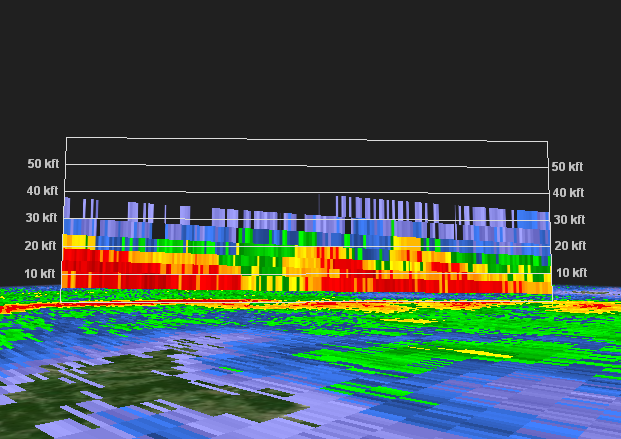 |
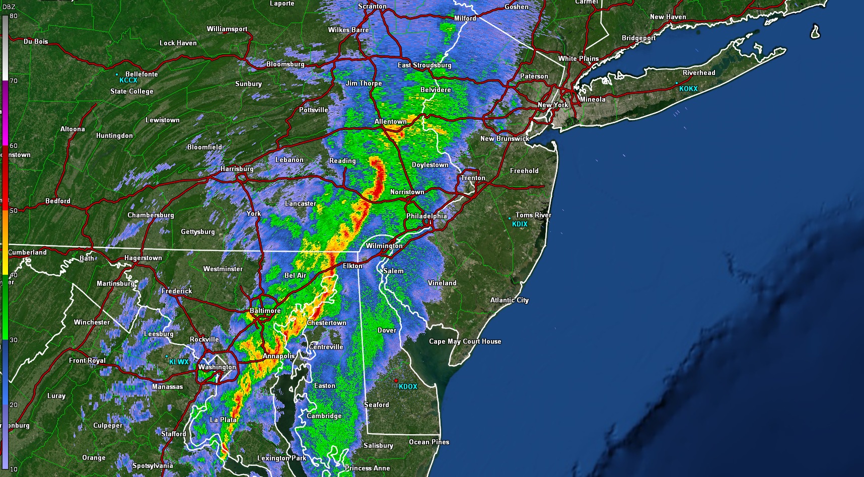
| Figure 1: KDOX radar reflectivity factor for the 0.5 degree elevation angle valid at 0300 UTC 1 November 2019. A line of severe thunderstorms is seen, including a bowing segment likely producing wind damage over eastern Pennsylvania. Lighter rain showers were occurring ahead of the main line. The widest area of moderate to heavy rain is seen over eastern Pennsylvania, which combined with southwest-to-northeast storm motions led to flash flooding in that area. | Figure 2: KDOX along-line radar reflectivity cross-section of the line of storms over southeast Pennsylvania valid at 0300 UTC 1 November 2019, the same time as Figure 1. Typical of autumn convection in the region, these storms were not especially tall. 50 dBz echoes, denoted by red shadings, do not extend above 20,000 feet, with storm tops of around 30,000 feet. |
 |
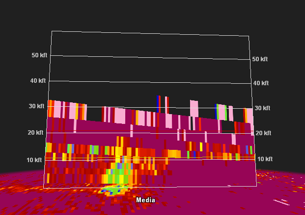 |
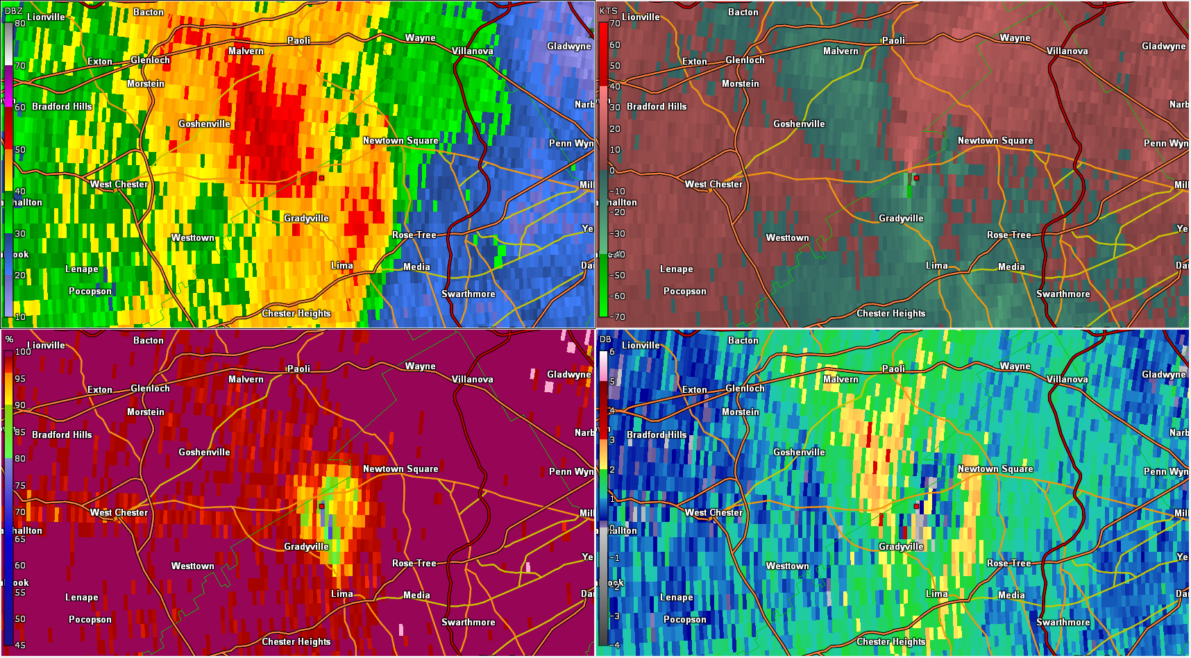
| Figure 3: KDIX radar reflectivity factor (top left), storm relative velocity (SRM; top right), correlation coefficient (CC, bottom left) and differential reflectivity (ZDR; bottom right),) for the 0.5 degree elevation angle valid at 0329 UTC 1 November 2019. This was at the time of the Delaware County tornado. A strong velocity couplet is seen in the SRM data. A rather large tornado debris signature (TDS) can be seen in the CC data, represented by the reduced CC values. The reduced ZDR values in the area are also indicative of a TDS. | Figure 4: KDIX correlation coefficient (CC) cross-section for the storm producing the Delaware County, PA tornado valid at 0332 UTC 1 November 2019. Reduced values of CC, indicative of lofted tornadic debris, can be seen extending to nearly 10,000 feet before the data becomes noisy. While each case is different, a TDS of this depth is quite typical of an EF2 tornado and lends more confidence to the rating estimate. Several structures were damaged, a couple severely, by this brief but strong tornado, with numerous trees damaged or snapped. |
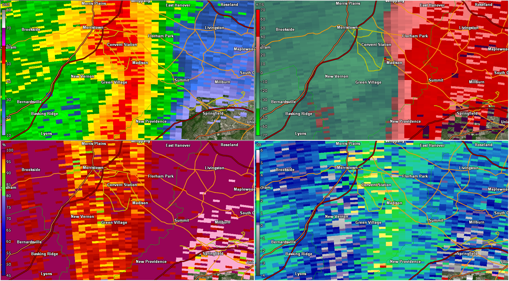 |
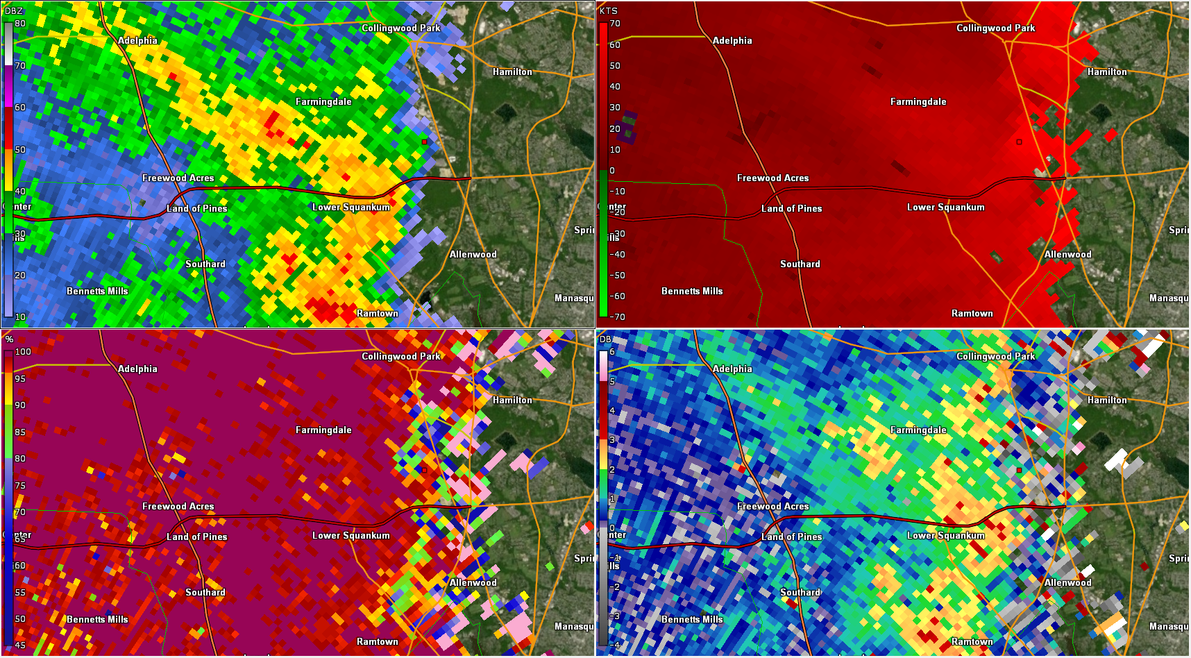 |
| Figure 5: KDIX radar reflectivity factor (top left), storm relative velocity (SRM; top right), correlation coefficient (CC, bottom left) and differential reflectivity (ZDR; bottom right),) for the 0.5 degree elevation angle valid at 0425 UTC 1 November 2019. A second tornado during this event occurred at this time in Madison, NJ. A subtle “break” in the reflectivity can be seen, a signature sometimes seen with QLCS tornadoes. There is some indication of a velocity couplet in the SRM data, but it is quite noisy and difficult to decipher. The somewhat reduced CC values are likely indicative of non-uniform radar beam filling and are not consistent with a TDS like the one in Figure 3. | Figure 6: KDIX radar reflectivity factor (top left), base velocity (V; top right), correlation coefficient (CC, bottom left) and differential reflectivity (ZDR; bottom right),) for the 0.5 degree elevation angle valid at 0503 UTC 1 November 2019. Another area of severe damage, which was surveyed by the NWS, occurred in Monmouth County, NJ near Wall Twp. While there was some evidence of rotation in radar data, the damage was found to be caused by straight line winds. The bright red colors in the V data represent winds of around 70 kt (80 mph) at just 1200 feet above the surface. These winds can be transported to the surface and accelerated by convective processes, and it was estimated that wind gusts of around 100 mph occurred in Wall Twp. |