
Numerous severe thunderstorms are expected across a broad region from the Ohio Valley to the Mid-Atlantic and Northeast States today into tonight. Swaths of damaging wind gusts are expected and some tornadoes are possible. Bertha is expected to bring tropical storm conditions to portions of the Gulf Coast from the Florida Panhandle westward to southeastern Louisiana later today and Wednesday. Read More >
Overview
|
Quasi-zonal midlevel flow was in place across the Northeast on 19 June 2019, with weak vorticity maxima progressing through the region. This midlevel flow was nearly parallel to a surface front stretching west-to-east across the northern Mid-Atlantic, which did not permit much movement of the front. To the south of the nearly-stationary front, a very moist and unstable environment was present (MLCAPE 1500-2000 J/kg; precipitable water approaching 2 inches). The presence of a surface front along with weak midlevel perturbations promoted the development of convection several times from afternoon through the overnight hours in portions of the area. Weak deep-layer shear and very moist low levels resulted in slow-moving storms that generated weak cold pools. Storms would reinitiate along the outflow boundaries associated with the cold pools, but their weak nature resulted in the training of storms over the same areas multiple times. Additionally, a deep above-freezing layer of air was present, which allowed for highly efficient precipitation rates with the storms. This is a setup quite favorable for flash flooding. During the late afternoon and early evening, storms developed from the north side of Philadelphia eastward to the Fort Dix area, where several reports of 2-4 inches of rain occurred in a 2-hour period, along with reports of road closures from flooding. Late in the evening into the overnight hours, more storms developed to the south of Philadelphia, spreading very slowly northward. Numerous instances of flash flooding were reported from the Reading area in Berks County eastward to Gloucester, Camden, and Burlington Counties in southern New Jersey. The excessive rainfall resulted in the lengthy closure of Interstate 295 in New Jersey in the pre-dawn hours of 20 June, dozens of water rescues throughout the area, the evacuation of several homes along the rapidly rising Rancocas Creek in Burlington County, and inundation of several homes and businesses in the Bellmawr, Barrington, and Brooklawn areas. |
 Polarimetric estimated storm total precipitation in southern New Jersey ending 1157 UTC 20 June 2019.  Polarimetric estimated storm total precipitation in southeast Pennsylvania ending 1157 UTC 20 June 2019. |
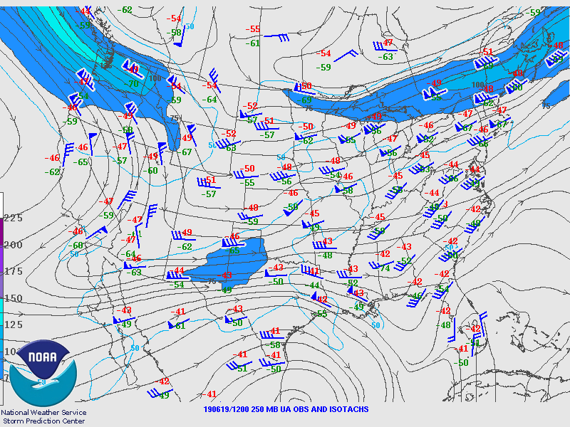
Synoptic Overview at 12z 19 June 2019 (courtesy of SPC)
 |
 |
 |
| Figure 1: 250-mb analysis | Figure 2: 300-mb analysis | Figure 3: 500-mb analysis |
 |
 |
 |
| Figure 4: 700-mb analysis | Figure 5: 850-mb analysis | Figure 6: 925-mb analysis |
Synoptic Overview at 00z 20 June 2019 (courtesy of SPC)
 |
 |
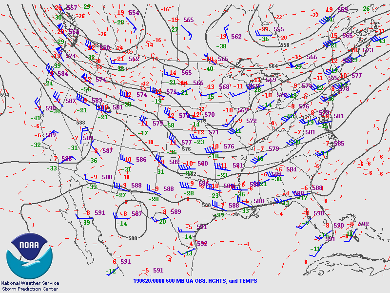 |
| Figure 7: 250-mb analysis | Figure 8: 300-mb analysis | Figure 9: 500-mb analysis |
 |
 |
 |
| Figure 10: 700-mb analysis | Figure 11: 850-mb analysis | Figure 12: 925-mb analysis |
Surface Maps (courtesy of WPC)
 |
 |
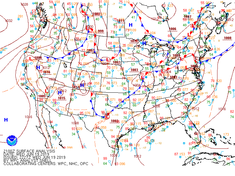 |
| Figure 13: 15z surface map | Figure 14: 18z surface map | Figure 15: 21z surface map |
 |
 |
 |
| Figure 16: 00z surface map | Figure 17: 03z surface map | Figure 18: 06z surface map |
 |
 |
 |
| Figure 19: 12z Upton, NY sounding | Figure 20: 12z Sterling, VA sounding | Figure 21: 12z Wallops Island, VA sounding |
 |
 |
 |
| Figure 22: 00z Upton, NY sounding | Figure 23: 00z Sterling, VA sounding | Figure 24: 00z Wallops Island, VA sounding |
 |
| Figure 1: Plot of local storm reports and storm-based warnings for the 19-20 June 2019 flooding event. Click here for more information. |
NWUS51 KPHI 231744
LSRPHI
PRELIMINARY LOCAL STORM REPORT...SUMMARY
NATIONAL WEATHER SERVICE MOUNT HOLLY NJ
144 PM EDT SUN JUN 23 2019
..TIME... ...EVENT... ...CITY LOCATION... ...LAT.LON...
..DATE... ....MAG.... ..COUNTY LOCATION..ST.. ...SOURCE....
..REMARKS..
0330 PM FLOOD TULLYTOWN 40.14N 74.82W
06/19/2019 BUCKS PA EMERGENCY MNGR
FLOODING AT US 13 AND THE LEVITTOWN PARKWAY.
WATER RESCUE REPORTED. TIME ESTIMATED FROM
RADAR.
0536 PM FLOOD 1 SSW EDDINGTON 40.07N 74.95W
06/19/2019 BUCKS PA EMERGENCY MNGR
FLOODING AT STATION AVENUE WITH POSSIBLE
ROAD CLOSURE. WATER RESCUE REPORTED. TIME
ESTIMATED FROM RADAR.
0536 PM FLOOD CROYDON 40.09N 74.90W
06/19/2019 BUCKS PA EMERGENCY MNGR
SEVERAL ROADWAYS IMPASSABLE AND WATER
RESCUES ONGOING. TIME ESTIMATED FROM RADAR.
0619 PM FLOOD 1 E BRISTOL TWP 40.12N 74.85W
06/19/2019 BUCKS PA PUBLIC
FLOODING NEAR THE BENSALEM TURNPIKE PLAZA.
0623 PM FLOOD 2 E BURLINGTON 40.08N 74.82W
06/19/2019 BURLINGTON NJ NWS EMPLOYEE
SEVERAL ROADWAYS ARE CLOSED DUE TO FLOODING.
1.8 INCHES OF RAIN FELL IN 45 MINUTES.
0625 PM FLASH FLOOD BURLINGTON 40.08N 74.85W
06/19/2019 BURLINGTON NJ LAW ENFORCEMENT
WIDESPREAD ROADWAY FLOODING.
0630 PM FLOOD PEMBERTON 39.98N 74.68W
06/19/2019 BURLINGTON NJ EMERGENCY MNGR
SEVERAL FLOODED ROADWAYS IN PEMBERTON.
SEVERAL CARS WERE STALLED BUT HAVE SINCE
ESCAPED THE WATERS.
0640 PM FLASH FLOOD 1 NNW HOLMESBURG 40.05N 75.03W
06/19/2019 PHILADELPHIA PA OTHER FEDERAL
THE RIVER GAUGE ALONG PENNYPACK CREEK IN
NORTHEAST PHILADELPHIA EXCEEDED FLOOD STAGE.
0655 PM FLOOD 1 ENE DELRAN 40.02N 74.94W
06/19/2019 BURLINGTON NJ TRAINED SPOTTER
STREET FLOODING AT US 130 AND FAIRVIEW
STREET IN DELRAN.
0700 PM FLOOD 1 S COLUMBUS 40.06N 74.72W
06/19/2019 BURLINGTON NJ PUBLIC
FLOODING ALONG US ROUTE 206 NEAR THE
COLUMBUS MARKET.
0714 PM FLOOD 1 NW CHERRY HILL TWP 39.94N 75.04W
06/19/2019 CAMDEN NJ DEPT OF HIGHWAYS
ROUTE 38 IS CLOSED IN BOTH DIRECTIONS DUE TO
FLOODING AT LONGWOOD AVENUE IN CHERRY HILL,
NJ.
0730 PM FLASH FLOOD 1 W BRISTOL 40.10N 74.88W
06/19/2019 BUCKS PA NEWSPAPER
STATE ROAD IN CROYDON WAS DAMAGED BY FLOOD
WATERS, FORCING ITS CLOSURE, AFTER THE PUMP
STATION BECAME INUNDATED WITH RUNOFF.
0730 PM FLOOD 2 SSW FORT DIX 40.00N 74.64W
06/19/2019 BURLINGTON NJ PUBLIC
FLOODING ON JULIUSTOWN ROAD.
0730 PM FLOOD BROWNS MILLS 39.97N 74.58W
06/19/2019 BURLINGTON NJ PUBLIC
STREET FLOODING OCCURRING.
0745 PM FLASH FLOOD 2 ENE VINCENTOWN 39.94N 74.72W
06/19/2019 BURLINGTON NJ LAW ENFORCEMENT
VINCENTOWN-PEMBERTON ROAD CLOSED FROM US
ROUTE 206 TO BURRS MILL ROAD DUE TO
FLOODING.
0755 PM HEAVY RAIN 2 SSW NEW EGYPT 40.04N 74.55W
06/19/2019 M3.02 INCH BURLINGTON NJ MESONET
0800 PM HEAVY RAIN 1 WSW PLUMSTED TWP 40.08N 74.56W
06/19/2019 M2.11 INCH BURLINGTON NJ MESONET
0800 PM HEAVY RAIN 1 N BENSALEM 40.12N 74.93W
06/19/2019 M2.46 INCH BUCKS PA MESONET
0800 PM HEAVY RAIN 1 NNE COOPERSTOWN 40.06N 74.89W
06/19/2019 M2.24 INCH BURLINGTON NJ MESONET
0800 PM HEAVY RAIN 1 NNE BURLINGTON TWP 40.08N 74.82W
06/19/2019 M2.51 INCH BURLINGTON NJ MESONET
0800 PM HEAVY RAIN 1 SW BURLINGTON 40.06N 74.87W
06/19/2019 M2.64 INCH BURLINGTON NJ MESONET
0800 PM FLASH FLOOD MEDFORD TWP. 39.90N 74.82W
06/19/2019 BURLINGTON NJ DEPT OF HIGHWAYS
NJ ROUTE 70 EASTBOUND CLOSED AT NORTH MAIN
STREET DUE TO FLOODING.
0800 PM HEAVY RAIN BRISTOL 40.10N 74.85W
06/19/2019 M2.01 INCH BUCKS PA MESONET
0803 PM HEAVY RAIN 1 NNE CROYDON 40.10N 74.89W
06/19/2019 M2.33 INCH BUCKS PA MESONET
0803 PM HEAVY RAIN 1 SSW BRISTOL TWP 40.11N 74.87W
06/19/2019 M2.35 INCH BUCKS PA MESONET
0812 PM FLOOD 2 NW TABERNACLE 39.87N 74.73W
06/19/2019 BURLINGTON NJ PUBLIC
MPING REPORT OF RIVER FLOODING ALONG WITH
YARD AND/OR BASEMENT FLOODING.
0820 PM HEAVY RAIN 2 WSW MEDFORD 39.88N 74.85W
06/19/2019 M2.41 INCH BURLINGTON NJ MESONET
0820 PM HEAVY RAIN 1 E LUMBERTON 39.97N 74.78W
06/19/2019 M2.40 INCH BURLINGTON NJ MESONET
0834 PM FLOOD 1 W BRISTOL 40.10N 74.88W
06/19/2019 BUCKS PA EMERGENCY MNGR
FLOODING ON STATE ROAD IN BRISTOL TWP.
FIRETRUCKS ARE PUMPING WATER OUT OF ROADWAY.
1045 PM HEAVY RAIN TABERNACLE 39.84N 74.71W
06/19/2019 M5.06 INCH BURLINGTON NJ PUBLIC
DAILY TOTAL.
1050 PM HEAVY RAIN LAKE PINE 39.87N 74.85W
06/19/2019 M3.58 INCH BURLINGTON NJ TRAINED SPOTTER
DAILY TOTAL.
1100 PM HEAVY RAIN 1 WSW TABERNACLE 39.83N 74.73W
06/19/2019 M5.25 INCH BURLINGTON NJ PUBLIC
DAILY TOTAL.
1155 PM FLOOD WERNERSVILLE 40.33N 76.08W
06/19/2019 BERKS PA PUBLIC
WIDESPREAD ROADWAY FLOODING.
1215 AM FLASH FLOOD MANTUA 39.79N 75.18W
06/20/2019 GLOUCESTER NJ DEPT OF HIGHWAYS
NJ ROUTE 45 CLOSED IN BOTH DIRECTIONS DUE TO
FLOODING.
1224 AM FLASH FLOOD ROBESONIA 40.35N 76.14W
06/20/2019 BERKS PA PUBLIC
WATER RESCUE AT CHURCH STREET NEAR RAILROAD
CROSSING. SOCIAL MEDIA PHOTO SHOWS WATER
ABOUT TWO FEET FROM THE BASE OF THE
OVERPASS.
1225 AM FLASH FLOOD 2 NNE MARION TWP 40.42N 76.18W
06/20/2019 BERKS PA PUBLIC
CREWS DISPATCHED TO THE 200 BLOCK OF HOST
CHURCH RD FOR A WATER RESCUE OF A CAR
STRANDED IN HIGH WATER.
1230 AM FLASH FLOOD GARFIELD PARK 39.70N 75.55W
06/20/2019 NEW CASTLE DE DEPT OF HIGHWAYS
DE ROUTE 9 SOUTHBOUND NEAR MEMORIAL DRIVE IS
CLOSED DUE TO FLOODING.
1242 AM FLASH FLOOD 1 SW READING 40.32N 75.93W
06/20/2019 BERKS PA PUBLIC
SEVERAL WATER RESCUES REPORTED IN THE AREA
OF LANCASTER AVENUE AND MORGANTOWN ROAD.
1250 AM FLASH FLOOD 1 E GIBBSTOWN 39.83N 75.26W
06/20/2019 GLOUCESTER NJ DEPT OF HIGHWAYS
NJ ROUTE 44 CLOSED IN BOTH DIRECTIONS DUE TO
FLOODING.
1257 AM FLASH FLOOD 1 W KENHORST 40.31N 75.95W
06/20/2019 BERKS PA PUBLIC
REPORTS OF FLOODED RESIDENCES AND SEVERAL
WATER RESCUES IN CUMRU TWP.
0100 AM FLASH FLOOD 1 SW MOHNTON 40.27N 76.00W
06/20/2019 BERKS PA NEWSPAPER
A DRIVEWAY ON YORKSHIRE ROAD WAS WASHED OUT,
STRANDING TWO CARS FURTHER UP THE DRIVEWAY.
DELAYED REPORT FROM THURSDAY MORNING. TIME
ESTIMATED.
0101 AM FLASH FLOOD WYOMISSING 40.33N 75.95W
06/20/2019 BERKS PA PUBLIC
SEVERAL WATER RESCUES REQUIRED AT SUNNYSIDE
AVENUE AND PARK ROAD.
0120 AM FLOOD 1 SW HAYDEN PARK 39.69N 75.62W
06/20/2019 NEW CASTLE DE DEPT OF HIGHWAYS
AIRPORT ROAD CLOSED AT NONESUCH CREEK.
0130 AM FLASH FLOOD 1 SSW WEST READING 40.33N 75.95W
06/20/2019 BERKS PA NEWSPAPER
THE READING PUBLIC MUSEUM WAS DAMAGED FROM
FLASH FLOODING. TREES WERE UPROOTED ON AND
NEAR THE PROPERTY, AND A METAL SCULPTURE WAS
WASHED AWAY. TIME ESTIMATED FROM RADAR AND
NEARBY REPORTS.
0133 AM FLASH FLOOD 1 SSE MUHLENBERG TWP 40.37N 75.93W
06/20/2019 BERKS PA PUBLIC
SEVERAL CARS STALLED AND WATER RESCUES
REQUIRED NEAR ROUTE 12 AND 5TH STREET.
0139 AM FLASH FLOOD 1 E SOUTH PHILADELPHIA 39.91N 75.19W
06/20/2019 PHILADELPHIA PA DEPT OF HIGHWAYS
SEVERAL ROADS CLOSED IN THE AREA OF 38TH
STREET, 34TH STREET, 26TH STREET, AND
UNIVERSITY AVENUE FROM FLASH FLOODING.
0150 AM FLASH FLOOD WYOMISSING 40.34N 75.96W
06/20/2019 BERKS PA NEWSPAPER
RESIDENTS OF CAMBRIDGE COMMONS APARTMENTS
NEEDING RESCUE WITH 6 FEET OF WATER REPORTED
IN THE BUILDING.
0152 AM FLASH FLOOD 1 N SHILLINGTON 40.31N 75.97W
06/20/2019 BERKS PA BROADCAST MEDIA
SEVERAL REPORTS OF FLASH FLOODING IN THIS
AREA. A 24-HOUR STORE WAS FLOODED WITH
SEVERAL PEOPLE STUCK INSIDE THE BUILDING.
SEVERAL CARS WERE STUCK IN WATER NEAR THIS
LOCATION AND IN KENHORST BORO AS WELL.
0200 AM FLASH FLOOD SPRING TWP 40.32N 76.01W
06/20/2019 BERKS PA PUBLIC
WATER RESCUE ON ROUTE 724 WITH THE ROAD
UNDER TWO TO THREE FEET OF WATER. TIME
ESTIMATED BASED ON SOCIAL MEDIA REPORTS.
0200 AM FLASH FLOOD 2 SSW GREENWICH TWP 39.81N 75.31W
06/20/2019 GLOUCESTER NJ DEPT OF HIGHWAYS
FLOODING ON INTERSTATE 295 BETWEEN
INTERCHANGES 13 AND 14 WITH LANE CLOSURES.
0200 AM FLASH FLOOD WASHINGTON PARK 39.66N 75.57W
06/20/2019 NEW CASTLE DE DEPT OF HIGHWAYS
STATE HIGHWAY 9 CLOSED BETWEEN CARROLL DRIVE
AND DOBBINSVILLE FROM FLASH FLOODING. TIME
ESTIMATED FROM SOCIAL MEDIA.
0205 AM FLASH FLOOD GLOUCESTER CITY 39.89N 75.12W
06/20/2019 CAMDEN NJ TRAINED SPOTTER
SEVERAL CARS PARTIALLY SUBMERGED AT THE
INTERSECTION OF MARKET ST. AND BROADWAY.
0210 AM FLASH FLOOD 1 S MAPLE SHADE 39.94N 75.00W
06/20/2019 CAMDEN NJ OTHER FEDERAL
THE CHERRY HILL RIVER GAUGE ON THE SOUTH
BRANCH OF THE PENNSAUKEN CREEK REACHED FLOOD
STAGE.
0210 AM FLASH FLOOD BELLMAWR 39.87N 75.08W
06/20/2019 CAMDEN NJ DEPT OF HIGHWAYS
FLOODING ON INTERSTATE 295 IN BOTH
DIRECTIONS NEAR INTERCHANGE 28 WITH LANE
CLOSURES.
0210 AM FLASH FLOOD MOUNT HOLLY 39.99N 74.78W
06/20/2019 BURLINGTON NJ OTHER FEDERAL
THE RIVER GAUGE ON THE NORTH BRANCH OF THE
RANCOCAS CREEK AT IRONWORKS PARK REACHED
FLOOD STAGE.
0215 AM FLASH FLOOD 1 NNW MANTUA 39.81N 75.18W
06/20/2019 GLOUCESTER NJ DEPT OF HIGHWAYS
FLOODING IS BLOCKING ALL NORTHBOUND LANES OF
THE NEW JERSEY TURNPIKE IN WEST DEPTFORD
TOWNSHIP.
0215 AM FLASH FLOOD 1 NW CHERRY HILL TWP 39.94N 75.04W
06/20/2019 CAMDEN NJ DEPT OF HIGHWAYS
NJ ROUTE 38 CLOSED IN BOTH DIRECTIONS AT
LONGWOOD AVENUE.
0230 AM FLASH FLOOD 1 NE CHESTER SPRINGS 40.11N 75.60W
06/20/2019 CHESTER PA DEPT OF HIGHWAYS
FLASH FLOODING CLOSED CLOVER MILL ROAD NEAR
PIKE SPRINGS ROAD. TIME ESTIMATED FROM RADAR
AND NEARBY REPORTS.
0230 AM FLASH FLOOD 1 W DOUGLASS TWP 40.32N 75.69W
06/20/2019 BERKS PA PUBLIC
CORRECTS TIME OF PREVIOUS FLASH FLOOD REPORT
FROM 1 W DOUGLASS TWP. MANATAWNEY CREEK
BRIDGE ON STATE HIGHWAY 562 WASHED OUT. TIME
ESTIMATED FROM NEARBY REPORTS OF FLOODING.
0258 AM FLASH FLOOD LANSDOWNE 39.94N 75.26W
06/20/2019 DELAWARE PA FIRE DEPT/RESCUE
WATER RESCUE OF A STRANDED DRIVER.
0300 AM FLASH FLOOD ELLISBURG 39.92N 75.00W
06/20/2019 CAMDEN NJ BROADCAST MEDIA
CORRECTS TIME OF PREVIOUS FLASH FLOOD REPORT
FROM ELLISBURG BASED ON INFORMATION FROM LAW
ENFORCEMENT. SEVERAL WATER RESCUES IN THE
KINGSTON ESTATES AREA. RUSHING WATER
COVERING SEVERAL ROADS IN THE COMMUNITY.
DAMAGE TO SEVERAL HOMES. TIME ESTIMATED FROM
SOCIAL MEDIA REPORTS.
0300 AM FLASH FLOOD 2 S VINCENTOWN 39.91N 74.74W
06/20/2019 BURLINGTON NJ DEPT OF HIGHWAYS
FLASH FLOODING ON U.S. HIGHWAY 206 NEAR
RIDGE ROAD IN SOUTHAMPTON TWP. TIME
ESTIMATED FROM RADAR AND NEARBY REPORTS.
0315 AM FLASH FLOOD 1 NNE MAPLE SHADE 39.96N 75.00W
06/20/2019 BURLINGTON NJ DEPT OF HIGHWAYS
NJ ROUTE 73 CLOSED IN BOTH DIRECTIONS AROUND
NORTH STILES AVENUE.
0330 AM FLASH FLOOD 1 E MAPLE SHADE 39.96N 74.98W
06/20/2019 BURLINGTON NJ NEWSPAPER
CORRECTS TIME OF PREVIOUS FLASH FLOOD REPORT
FROM 1 E MAPLE SHADE BASED ON INFORMATION
FROM LAW ENFORCEMENT. NEW ALBANY ROAD CLOSED
BETWEEN LENOLA ROAD AND CAMDEN AVENUE FROM
FLOOD DAMAGE. FLOODING ALSO CAUSED TREES TO
FALL ON MOUNT LAUREL ROAD NEAR ROUTE 38.
0330 AM FLASH FLOOD BARRINGTON 39.87N 75.05W
06/20/2019 CAMDEN NJ BROADCAST MEDIA
CORRECTS TIME OF PREVIOUS FLASH FLOOD REPORT
FROM BARRINGTON. NUMEROUS WATER RESCUES
REPORTED ON I-295 IN BELLMAWR AND IN THE
BARRINGTON AREA. U.S. 30 CLOSED BETWEEN
COPLEY AVENUE AND STATE HIGHWAY 41.
0330 AM HEAVY RAIN 2 SSW MEDFORD 39.86N 74.84W
06/20/2019 M6.59 INCH BURLINGTON NJ TRAINED SPOTTER
3.5 INCHES OF RAIN FELL BETWEEN 7:30 PM AND
10 PM ON 6/19 WITH AN ADDITIONAL 2.59 INCHES
BETWEEN 2 AM AND 3 AM ON 6/20.
0330 AM FLASH FLOOD 2 SSW EVESHAM TWP 39.86N 74.92W
06/20/2019 BURLINGTON NJ DEPT OF HIGHWAYS
STATE HIGHWAY 73 NORTHBOUND NEAR COUNTY ROAD
685 CLOSED FROM FLOODING. TIME ESTIMATED
FROM NEARBY SOCIAL MEDIA REPORTS.
0330 AM FLASH FLOOD 1 S VALLEY FORGE 40.09N 75.46W
06/20/2019 CHESTER PA DEPT OF HIGHWAYS
FLASH FLOODING OF VALLEY CREEK FORCED THE
CLOSURE OF STATE HIGHWAY 252 NEAR THE
MONTGOMERY AND CHESTER COUNTY LINE. TIME
ESTIMATED FROM RADAR AND NEARBY SOCIAL MEDIA
REPORTS.
0350 AM FLASH FLOOD HADDONFIELD 39.90N 75.02W
06/20/2019 CAMDEN NJ OTHER FEDERAL
THE RIVER GAUGE ON THE COOPER RIVER AT
HADDONFIELD REACHED FLOOD STAGE.
0355 AM FLASH FLOOD MEDFORD TWP. 39.90N 74.82W
06/20/2019 BURLINGTON NJ OTHER FEDERAL
THE RIVER GAUGE ON THE SOUTHWEST BRANCH OF
THE RANCOCAS CREEK REACHED FLOOD STAGE.
0409 AM FLASH FLOOD BROOKLAWN 39.88N 75.12W
06/20/2019 CAMDEN NJ DEPT OF HIGHWAYS
CORRECTS TIME OF PREVIOUS FLASH FLOOD REPORT
FROM BROOKLAWN. U.S. HIGHWAY 130 CLOSED AT
STATE HIGHWAY 47 FROM FLASH FLOODING.
0415 AM FLASH FLOOD WESTVILLE 39.88N 75.12W
06/20/2019 CAMDEN NJ DEPT OF HIGHWAYS
STATE HIGHWAY 47 CLOSED IN WESTVILLE FROM
FLASH FLOODING.
0435 AM FLASH FLOOD CHESTERBROOK 40.08N 75.46W
06/20/2019 CHESTER PA OTHER FEDERAL
THE RIVER GAUGE ON VALLEY CREEK NEAR VALLEY
FORGE REACHED FLOOD STAGE.
0435 AM FLASH FLOOD 1 E FAIRVIEW 39.91N 75.09W
06/20/2019 CAMDEN NJ DEPT OF HIGHWAYS
U.S. HIGHWAY 130 CLOSED NEAR STATE HIGHWAY
168 IN HADDON TWP FROM FLASH FLOODING.
0437 AM FLASH FLOOD OAKLYN 39.91N 75.08W
06/20/2019 CAMDEN NJ DEPT OF HIGHWAYS
U.S. HIGHWAY 30 CLOSED BETWEEN COLLINGS
AVENUE AND U.S. HIGHWAY 130 IN COLLINGSWOOD.
0445 AM FLASH FLOOD 2 WSW WEST NORRITON 40.12N 75.41W
06/20/2019 MONTGOMERY PA DEPT OF HIGHWAYS
SOUTH TROOPER ROAD FLOODED BETWEEN VAN BUREN
AVENUE AND MONROE BOULEVARD WITH LANE
CLOSURES.
0450 AM FLASH FLOOD BELLMAWR 39.86N 75.08W
06/20/2019 CAMDEN NJ DEPT OF HIGHWAYS
STATE HIGHWAY 168 CLOSED NEAR THE NEW JERSEY
TURNPIKE FROM FLASH FLOODING.
0500 AM FLOOD LOWER PROVIDENCE 40.14N 75.41W
06/20/2019 MONTGOMERY PA TRAINED SPOTTER
SOUTH PARK AVE CLOSED NEAR WOODLAND AVE.
0500 AM FLASH FLOOD 1 N ORELAND 40.14N 75.18W
06/20/2019 MONTGOMERY PA TRAINED SPOTTER
WATER RESCUE ON PENNSYLVANIA AVE.
0510 AM HEAVY RAIN LAKE PINE 39.87N 74.85W
06/20/2019 M5.44 INCH BURLINGTON NJ TRAINED SPOTTER
SINCE 4PM WEDNESDAY.
0530 AM FLASH FLOOD 1 SSW WEST NORRITON 40.11N 75.39W
06/20/2019 MONTGOMERY PA DEPT OF HIGHWAYS
FLOODING ON BEIDLER ROAD AND HENDERSON ROAD,
FORCING ROAD CLOSURES. TIME ESTIMATED FROM
RADAR AND NEARBY REPORTS.
0600 AM HEAVY RAIN WRIGHTSTOWN 40.04N 74.62W
06/20/2019 M3.44 INCH BURLINGTON NJ TRAINED SPOTTER
0600 AM HEAVY RAIN SINKING SPRING 40.33N 76.02W
06/20/2019 M4.65 INCH BERKS PA TRAINED SPOTTER
FROM 9PM TO 6AM.
0620 AM HEAVY RAIN WESTAMPTON TWP 40.01N 74.84W
06/20/2019 M3.90 INCH BURLINGTON NJ PUBLIC
0625 AM HEAVY RAIN WEST DEPTFORD 39.84N 75.20W
06/20/2019 M4.51 INCH GLOUCESTER NJ PUBLIC
0627 AM HEAVY RAIN MT. EPHRAIM 39.88N 75.09W
06/20/2019 M4.41 INCH CAMDEN NJ COCORAHS
COCORAHS STATION NJ-CN-24 MOUNT EPHRAIM.
0637 AM HEAVY RAIN LEISURETOWNE 39.90N 74.70W
06/20/2019 M4.90 INCH BURLINGTON NJ COCORAHS
COCORAHS STATION NJ-BT-68 SOUTHAMPTON TWP.
1.6 SE.
0647 AM HEAVY RAIN 1 W EASTTOWN TWP 40.05N 75.45W
06/20/2019 M3.10 INCH CHESTER PA COCORAHS
COCORAHS STATION PA-CH-42 BERWYN.
0659 AM HEAVY RAIN 2 WNW BLUE BELL 40.17N 75.30W
06/20/2019 M2.11 INCH MONTGOMERY PA COCORAHS
COCORAHS STATION PA-MT-13 BLUE BELL 2.3 NW.
0700 AM HEAVY RAIN 1 NW DISTRICT TWP 40.47N 75.67W
06/20/2019 M2.01 INCH BERKS PA COCORAHS
COCORAHS STATION PA-BR-21 ALBURTIS 4.7 SW.
0700 AM HEAVY RAIN PENNSVILLE 39.65N 75.52W
06/20/2019 M2.05 INCH SALEM NJ COCORAHS
COCORAHS STATION NJ-SL-7 PENNSVILLE TWP 2.0
NNW.
0700 AM HEAVY RAIN 1 N WOODSHADE 39.67N 75.68W
06/20/2019 M2.05 INCH NEW CASTLE DE COCORAHS
COCORAHS STATION DE-NC-41 NEWARK 4 E.
0700 AM HEAVY RAIN 3 WNW GLASGOW 39.62N 75.79W
06/20/2019 M2.06 INCH NEW CASTLE DE COCORAHS
COCORAHS STATION DE-NC-2 NEWARK 3.9 SSW.
0700 AM HEAVY RAIN 2 NW WHITE CLAY CREEK 39.75N 75.75W
06/20/2019 M2.22 INCH NEW CASTLE DE COCORAHS
COCORAHS STATION DE-NC-1 NEWARK 5.3 N.
0700 AM HEAVY RAIN 1 N BIRMINGHAM TWP 39.93N 75.60W
06/20/2019 M2.28 INCH CHESTER PA COCORAHS
COCORAHS STATION PA-CH-9 WEST CHESTER 2.4
SSE.
0700 AM HEAVY RAIN EAST CALN TWP 40.02N 75.68W
06/20/2019 M2.31 INCH CHESTER PA COCORAHS
COCORAHS STATION PA-CH-46 DOWNINGTOWN 1.7
NE.
0700 AM HEAVY RAIN 1 NNW BRECKNOCK TWP. 40.25N 76.00W
06/20/2019 M2.36 INCH BERKS PA COCORAHS
COCORAHS STATION PA-BR-16 MOHNTON 2.8 SSW.
0700 AM HEAVY RAIN 1 WNW WEST WHITELAND TW 40.04N 75.66W
06/20/2019 M2.40 INCH CHESTER PA COCORAHS
COCORAHS STATION PA-CH-47 EXTON 1.5 WNW.
0700 AM HEAVY RAIN 1 N GLOUCESTER TWP 39.84N 75.04W
06/20/2019 M2.43 INCH CAMDEN NJ CO-OP OBSERVER
CO-OP OBSERVER STATION SMDN4 SOMERDALE 4 SW.
0700 AM HEAVY RAIN 2 SW HAINESPORT 39.97N 74.85W
06/20/2019 M2.55 INCH BURLINGTON NJ COCORAHS
COCORAHS STATION NJ-BT-62 HAINESPORT.
0700 AM HEAVY RAIN 2 WSW HAINESPORT 39.97N 74.86W
06/20/2019 M3.00 INCH BURLINGTON NJ COCORAHS
COCORAHS STATION NJ-BT-4 MOUNT LAUREL.
0700 AM HEAVY RAIN MOORESTOWN TWP 39.96N 74.96W
06/20/2019 M3.50 INCH BURLINGTON NJ COCORAHS
COCORAHS STATION NJ-BT-69 MOORESTOWN TWP 1.4
SW.
0700 AM HEAVY RAIN 2 N WYOMISSING 40.36N 75.96W
06/20/2019 M3.76 INCH BERKS PA COCORAHS
COCORAHS STATION PA-BR-31 READING 2.3 NW.
0700 AM HEAVY RAIN 1 SSW SPRING TWP 40.31N 76.01W
06/20/2019 M4.32 INCH BERKS PA COCORAHS
COCORAHS STATION PA-BR-29 READING 4.7 WSW.
0700 AM HEAVY RAIN BERNVILLE 40.44N 76.11W
06/20/2019 M5.44 INCH BERKS PA TRAINED SPOTTER
MOST OF THE RAIN FELL BETWEEN 10PM WED AND
3AM THU.
0700 AM HEAVY RAIN 1 N PENNSAUKEN 39.97N 75.07W
06/20/2019 M2.90 INCH CAMDEN NJ CO-OP OBSERVER
CORRECTS PREVIOUS HEAVY RAIN REPORT FROM 1 N
PENNSAUKEN.
0700 AM HEAVY RAIN 2 SW BERN TWP 40.37N 76.03W
06/20/2019 M3.96 INCH BERKS PA CO-OP OBSERVER
0706 AM HEAVY RAIN 1 ESE NEWLIN TWP 39.90N 75.69W
06/20/2019 M2.14 INCH CHESTER PA COCORAHS
COCORAHS STATION PA-CH-28 KENNETT SQUARE 4
NNE.
0706 AM FLOOD 2 SSE EASTAMPTON TWP 39.98N 74.74W
06/20/2019 BURLINGTON NJ DEPT OF HIGHWAYS
FLOODING OF RANCOCAS CREEK CLOSED U.S.
HIGHWAY 206 NORTH OF STATE HIGHWAY 38 IN
SOUTHAMPTON TWP.
0715 AM HEAVY RAIN 2 SSE CENTRE TWP 40.45N 76.01W
06/20/2019 M3.03 INCH BERKS PA COCORAHS
COCORAHS STATION PA-BR-28 MOHRSVILLE 2.2 SW.
0730 AM HEAVY RAIN NEWLIN TWP 39.91N 75.70W
06/20/2019 M2.24 INCH CHESTER PA COCORAHS
COCORAHS STATION PA-CH-11 UNIONVILLE 2.2 NE.
0756 AM HEAVY RAIN 1 NE MOORESTOWN 39.97N 74.93W
06/20/2019 M2.76 INCH BURLINGTON NJ COCORAHS
COCORAHS STATION NJ-BT-6 MOORESTOWN.
0800 AM HEAVY RAIN NWS MOUNT HOLLY 40.01N 74.82W
06/20/2019 E2.73 INCH BURLINGTON NJ OFFICIAL NWS OBS
0800 AM HEAVY RAIN DELRAN 40.02N 74.97W
06/20/2019 M3.05 INCH BURLINGTON NJ PUBLIC
0800 AM HEAVY RAIN 2 SSW MEDFORD LAKES 39.83N 74.81W
06/20/2019 M4.68 INCH BURLINGTON NJ COCORAHS
COCORAHS STATION NJ-BT-5 MEDFORD TWP 2.4
SSE.
0800 AM HEAVY RAIN 1 SSE WEST READING 40.33N 75.94W
06/20/2019 M4.66 INCH BERKS PA COCORAHS
COCORAHS STATION PA-BR-8 READING 1.2 SW.
0800 AM HEAVY RAIN 1 S WEST WYOMISSING 40.32N 75.99W
06/20/2019 M4.60 INCH BERKS PA COCORAHS
COCORAHS STATION PA-BR-2 READING 3.5 SW.
0800 AM HEAVY RAIN PHILADELPHIA INTERNATIO 39.88N 75.23W
06/20/2019 M4.42 INCH PHILADELPHIA PA ASOS
0800 AM HEAVY RAIN 2 E FORT DIX 40.02N 74.59W
06/20/2019 M4.02 INCH BURLINGTON NJ ASOS
0800 AM HEAVY RAIN READING REGIONAL AIRPOR 40.37N 75.96W
06/20/2019 M3.26 INCH BERKS PA ASOS
0800 AM HEAVY RAIN FORT WASHINGTON 40.15N 75.20W
06/20/2019 M2.86 INCH MONTGOMERY PA COCORAHS
COCORAHS STATION PA-MT-67 FORT WASHINGTON
0.8 NW.
0802 AM HEAVY RAIN 2 ESE FLEETWOOD 40.44N 75.79W
06/20/2019 M2.07 INCH BERKS PA COCORAHS
COCORAHS STATION PA-BR-7 FLEETWOOD 2 ESE.
0820 AM HEAVY RAIN 1 NNE BURLINGTON TWP 40.08N 74.82W
06/20/2019 M3.18 INCH BURLINGTON NJ COCORAHS
COCORAHS STATION NJ-BT-3 BURLINGTON 1.7 E.
0847 AM HEAVY RAIN NEW CASTLE COUNTY AIRPO 39.67N 75.61W
06/20/2019 M2.05 INCH NEW CASTLE DE ASOS
0900 AM HEAVY RAIN STRATFORD 39.84N 75.01W
06/20/2019 M2.00 INCH CAMDEN NJ PUBLIC
0900 AM HEAVY RAIN EXTON 40.03N 75.63W
06/20/2019 M3.62 INCH CHESTER PA TRAINED SPOTTER
0900 AM HEAVY RAIN SINKING SPRING 40.33N 76.02W
06/20/2019 M4.51 INCH BERKS PA PUBLIC
0900 AM HEAVY RAIN 1 SW WYOMISSING 40.33N 75.97W
06/20/2019 M4.95 INCH BERKS PA COCORAHS
COCORAHS STATION PA-BR-14 WYOMISSING 0.3 SW.
0900 AM HEAVY RAIN 1 NE LAKEHURST 40.02N 74.30W
06/20/2019 M2.90 INCH OCEAN NJ PUBLIC
0925 AM HEAVY RAIN WYOMISSING 40.33N 75.96W
06/20/2019 M5.00 INCH BERKS PA PUBLIC
1002 AM HEAVY RAIN 1 W MEDFORD LAKES 39.86N 74.81W
06/20/2019 M5.76 INCH BURLINGTON NJ COCORAHS
1004 AM HEAVY RAIN 2 E BURLINGTON 40.08N 74.82W
06/20/2019 M3.18 INCH BURLINGTON NJ NWS EMPLOYEE
1009 AM HEAVY RAIN 1 SSE SPRING TWP 40.31N 76.00W
06/20/2019 E4.32 INCH BERKS PA COCORAHS
1011 AM HEAVY RAIN 2 WSW BROOKFIELD 39.84N 75.63W
06/20/2019 M2.43 INCH CHESTER PA PUBLIC
1013 AM HEAVY RAIN EAST CALN TWP 40.02N 75.68W
06/20/2019 M2.31 INCH CHESTER PA COCORAHS
1018 AM FLOOD 1 NW CHADDS FORD TWP 39.89N 75.61W
06/20/2019 CHESTER PA DEPT OF HIGHWAYS
FLOODING OF BRANDYWINE CREEK CLOSED PORTIONS
OF POTTSTOWN PIKE, CREEK ROAD, CHADDS FORD
ROAD, AND HIGH STREET.
1026 AM HEAVY RAIN NEW CASTLE 39.66N 75.57W
06/20/2019 M3.00 INCH NEW CASTLE DE PUBLIC
1100 AM HEAVY RAIN WAYNE 40.04N 75.37W
06/20/2019 M4.35 INCH DELAWARE PA PUBLIC
1145 AM HEAVY RAIN THORNTON 39.91N 75.48W
06/20/2019 M2.01 INCH DELAWARE PA TRAINED SPOTTER
1206 PM HEAVY RAIN GIBBSTOWN 39.83N 75.28W
06/20/2019 M4.30 INCH GLOUCESTER NJ PUBLIC
0145 PM HEAVY RAIN BROOKLAWN 39.88N 75.12W
06/20/2019 E4.50 INCH CAMDEN NJ PUBLIC
&&
$$
CMS/TCD/JEO/DI/SFJ/VM
Bucks/Philadelphia/Burlington County Evening Flash Flooding
 |
 |
| Figure 1: KDIX radar loop of base reflectivity (top left), differential reflectivity (ZDR; top right), specific differential phase (KDP; bottom left), and correlation coefficient (CC; bottom right) from 1904 to 2358 UTC on 19 June 2019. The loop shows storms developing in two distinct areas: one to the south and east of Mount Holly, NJ, and the other on the north side of the Philadelphia metropolitan area between 1900 and 2100 UTC (the first half of the loop). In this phase of the event, storms kept regenerating on the southwestern side of the antecedent storms in Burlington County, NJ. This resulted in locally heavy rainfall between Mount Holly and Medford Lakes extending northeastward to the Pemberton area. Meanwhile, storms on the north side of Philadelphia progressed slowly eastward to near the Bristol and Burlington areas by 2100 UTC. Similar to the storms farther southeast, there is clearly regeneration occurring on the southwest side. During this phase of the event, most of the flooding reports occurred in southeastern Bucks and northeastern Philadelphia Counties (highly urbanized), where excessive rainfall rates (note the 3-5 deg/km KDP occurring as the storms move through these areas, a strong indication of intense rainfall) occurred. As the storms crossed the Delaware River, other storms developed downstream and upstream, allowing for more significant training to occur in the Burlington and Willingboro areas in Burlington County. More severe flooding occurred here, since the excessive rainfall rates occurred for a longer period of time (note the increasing size/extent of the high KDP values). The storms gradually congealed (i.e., the cold pools of the storms gradually strengthened) as they continued southeastward through Burlington County, with more storms developing west of Medford Lakes toward the Delaware River. With the antecedent storms occurring northeast of Medford Lakes, the new round of storms resulted in significant flash flooding between Mount Holly and Medford Lakes, with rapid rises on the Rancocas Creek and widespread road flooding in Pemberton. Note that throughout the loop, correlation coefficient within the precipitation is quite high (i.e., little or no mixing with hail), and there are indications of very large drops (high ZDR) near the reflectivity gradient of the precipitation on the southeast side (indication of strong updrafts). These signatures bolster confidence regarding the intense rainfall occurring with these storms. | Figure 2: Polarimetric instantaneous rainfall rates valid at 2234 UTC on 19 June 2019. A broad area of 3-6 inches per hour rainfall rates are depicted east of the New Jersey Turnpike in Burlington County at this time (in the Mount Holly and Pemberton areas and northeastward). Flash flooding was occurring by this time in these areas. |
 |
 |
| Figure 3: Polarimetric one-hour accumulations valid at 2301 UTC on 19 June 2019. A swath of 1.5 to 2.5 inches is estimated (again, in one hour's time) east of the New Jersey Turnpike near the Rancocas Creek and its tributaries in Burlington County. Widespread flooding was occurring in this area by this time. | Figure 4: Same as Fig. 3, valid at 2358 UTC on 19 June 2019. Widespread one-hour 1.5-3 inch totals are estimated in the Pemberton and Wrightstown areas in Burlington County, with flash flooding reported in these areas by this time. |
Overnight Southern New Jersey Flash Flooding
 |
 |
| Figure 5: Same as Fig. 1, valid from 0302 to 0701 UTC 20 June 2019. During this phase of the event, a west-to-east band of storms developed and continued to regenerate while lifting only very slowly northward through this four-hour period. The polarimetric signatures strongly suggest torrential downpours with the convection, particularly the storms that move slowly from northern New Castle County (including the Wilmington area) eastward through western Gloucester and Camden Counties. In particular, KDP values range from 3-6 deg/km as the storms congeal in Gloucester and Camden Counties between 0500 and 0700 UTC, and ZDR values of 2-4+ dB were observed in these areas (indicative of very large raindrops). The combination of the two implies excessive rain rates (large drop sizes and high concentrations of drops). The flash flooding was especially severe in New Jersey, as storms developed around 0300 UTC in front of the main band of storms that developed in Salem County and moved northeastward between 0430 UTC and 0700 UTC. This repeated training of storms, combined with excessive rainfall rates, resulted in widespread flooding in this region (including westward into Chester/Delaware Counties in Pennsylvania). Several neighborhoods were inundated, and major arteries were closed as a result of flash flooding (including Interstate 295 and the New Jersey Turnpike). | Figure 6: Polarimetric one-hour accumulation valid at 0537 UTC 20 June 2019 zoomed into southern New Jersey and adjacent portions of southeast Pennsylvania and northern Delaware. Note the 2-3 inch accumulations estimated along the I-295/New Jersey Turnpike corridors in Gloucester County in a fairly broad area. Widespread flooding was reported by this time in this area. |
 |
|
| Figure 7: Polarimetric instantaneous rainfall rate valid at 0547 UTC 20 June 2019 zoomed into Camden and Gloucester Counties. Radar estimates of 4-6+ inches per hour are estimated in a broad area along and east of the I-295 corridor at this time. With slow storm motions, this torrential rainfall occurred over several minutes in one particular location, leading to excessive runoff in a highly urbanized area. | Figure 8: Polarimetric storm-total rainfall ending at 1157 UTC June 20 2019 zoomed into the Philadelphia metropolitan area eastward to the Fort Dix area. A broad swath of 3-5 inches with local maxima approaching 6 inches is estimated from western Gloucester County to central Burlington County as a result of the combination of evening and overnight rainfall. These estimates are in good agreement with observations in this area. |
Overnight Berks County Flash Flooding
 |
 |
| Figure 9: Same as Fig. 1, valid from 0302 to 0459 UTC on 20 June 2019. A strong and slow-moving storm intensified as it approached the Reading area. The excessive rainfall rates and heavy urbanization combined to produce flash flooding in much of the Reading and Wyomissing area. Once again, polarimetric variables indicated the torrential rainfall well, with KDP in excess of 5 deg/km as the storm reached the Reading area, along with ZDR increasing to 2-5 dB (high concentration of large drops). | Figure 10: Polarimetric one-hour accumulation valid at 0502 UTC on 20 June 2019 centered on Berks County. Rainfall estimates exceeding two inches in an hour were present in the Reading area. Flash flooding typically occurs here with these rates. |
 |
|
| Figure 11: Polarimetric instantaneous rainfall rates valid at 0423 UTC on 20 June 2019 centered on Berks County. Radar estimates a fairly broad area of 3-7+ inch per hour rates near and south of Reading, which is where much of the flash flooding ended up occurring. | Figure 12: Polarimetric storm-total rainfall valid at 1157 UTC on 20 June 2019 zoomed into the Berks County area. Widespread estimates of 3-5 inches are seen near and west of Reading from the combination of evening and overnight rainfall. These estimates were consistent with observations in this area. |
 |
 |
 |
| Figure 1: Trace of the stage of Crosswicks Creet at Extonville (Burlington County, NJ) from 1200 UTC 19 June 2019 to 1200 UTC 23 June 2019 (blue), action stage (yellow), minor flood stage (orange), moderate flood stage (red), and major flood stage (magenta). Note that flood stages are shown only if the river level reaches less than one foot below that stage. In this case, the creek reaches minor flood stage on 20 June, well after the rainfall ended. | Figure 2: Same as Fig. 1, for the Cooper River at Haddonfield. In this case, the river reaches minor flood stage rapidly in the early morning hours of 20 June (shortly after the heaviest rainfall occurred). | Figure 3: Same as Fig. 1, for the North Branch Rancocas Creek at Iron Work Park. This gauge reached major flood stage on the morning of 20 June and remained there for a 24+ hour period! |
 |
 |
 |
| Figure 4: Same as Fig. 1, for the Southwest Branch Rancocas Creek at Medford. This gauge was mere inches from moderate flood stage during the morning of 20 June. | Figure 5: Same as Fig. 1, for the Greenwood Branch Rancocas Creek at New Lisbon. Similar to the gauge at Medford, this gauge was mere inches from moderate flood stage on the morning of 20 June. | Figure 6: Same as Fig. 1, for the North Branch Rancocas Creek at Pemberton. This gauge reached major flood stage on the morning of 20 June and remained there for a 24+ hour period as well. Several homes along the creek were inundated, and several bridges and roads were closed in the area for days as a result of the flooding. |
 |
||
| Figure 7: Same as Fig. 1, for the South Branch Rancocas Creek at Vincentown. The gauge reached moderate flood stage on 20 June. |


 Coastal Flood
 Marine Forecasts
 Text Products
 Climate Information
 Skywarn
 Submit Storm Report
 Weather Event Archives
 Forecast Discussion
 Emergency Managers
 Briefing Page