
A heat wave over the Southwest will intensify this week, peaking and expanding into the Intermountain West and northern High Plains this weekend. Critical to extremely critical fire weather conditions are forecast from the Northwest and the northern Great Basin this weekend. Particularly Dangerous Situation Red Flag Warnings have been issued. Read More >
Overview
|
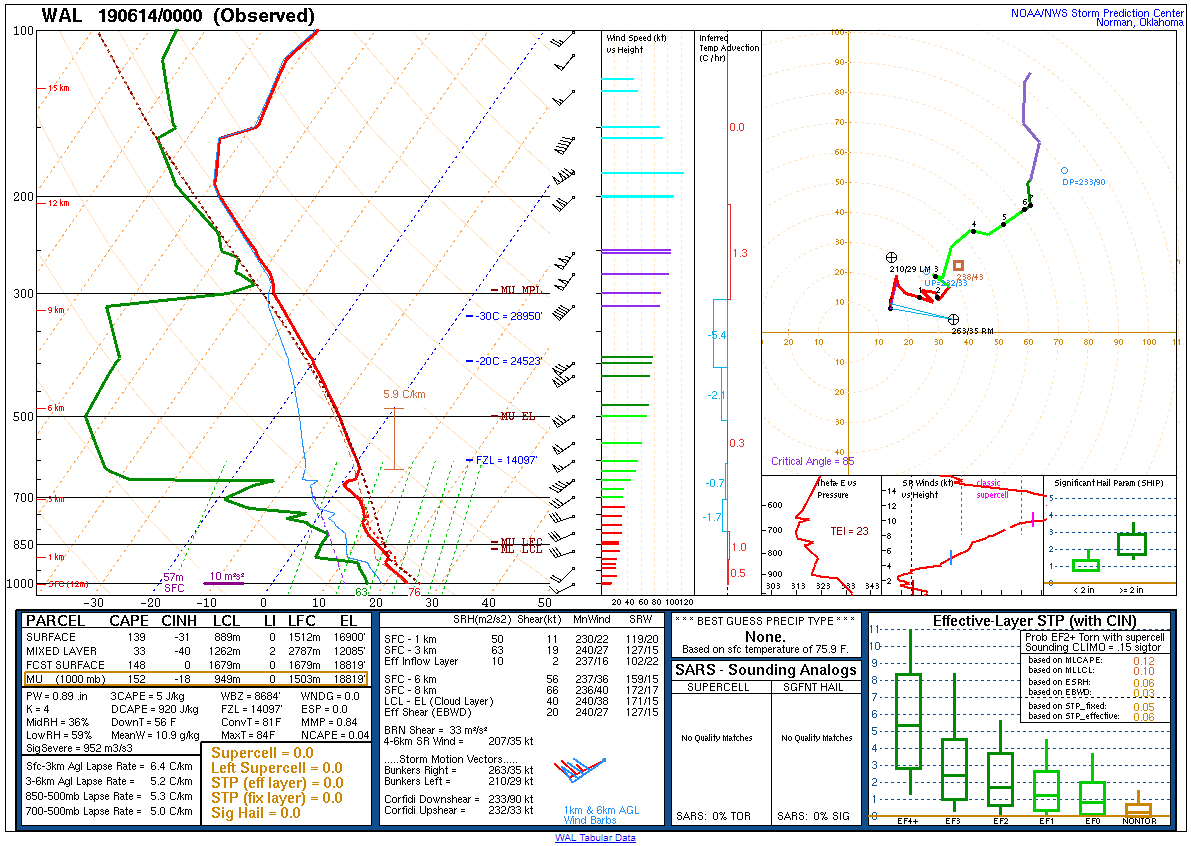
In advance of an amplified upper-level trough from Hudson Bay southward to the Great Lakes/Ohio Valley, a narrow corridor of unstable air surged northward into the coastal Mid-Atlantic region during the afternoon and evening of 13 June 2019. With steep low-level lapse rates and improving deep-layer shear aided by the approach of the trough, low-topped convection developed to our west along and in advance of a cold front during the afternoon. A particularly intense portion of the increasingly organized storms affected northeast Maryland. As the storm crossed Chesapeake Bay, it is suspected to have produced a waterspout that moved onshore, producing considerable damage to trees in Elk Neck State Park in Cecil County. Several reports of wind damage occurred eastward through southeast Cecil County, southern New Castle County, and Salem County, before the storm made a marked left turn into Gloucester County. The storm produced two tornadoes here: one in the Mullica Hill area and the other in the Deptford and Blackwood areas before dissipating in Camden County. Additionally, the organized line of storms produced torrential rainfall, with several reports of flash flooding in the Philadelphia and Wilmington areas. |
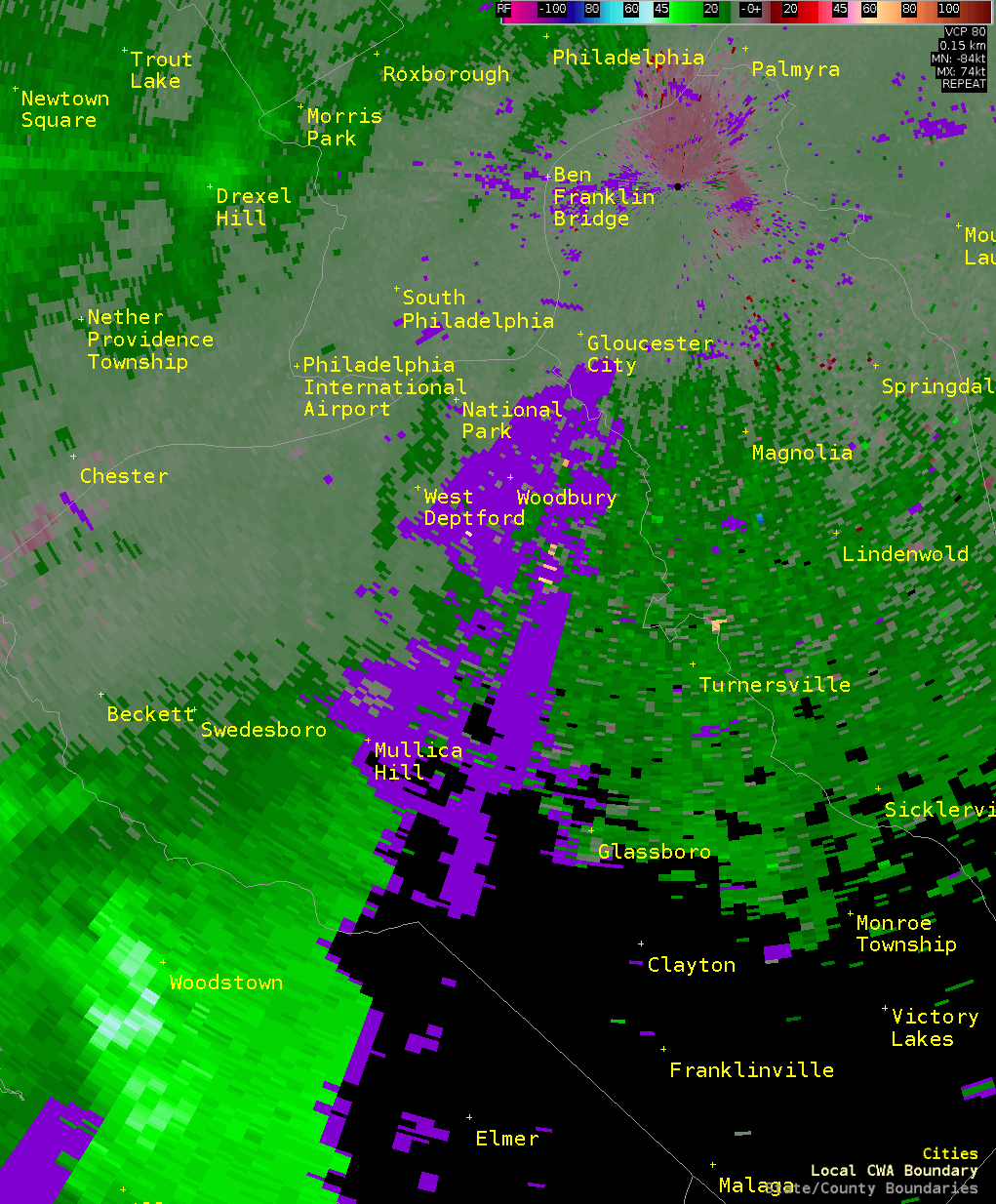 Composite radar loop of the Gloucester County tornadoes on 13 June 2019. |
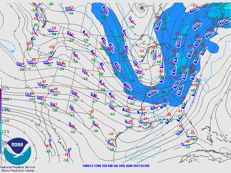
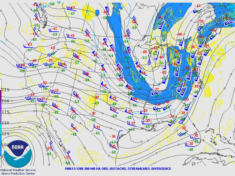
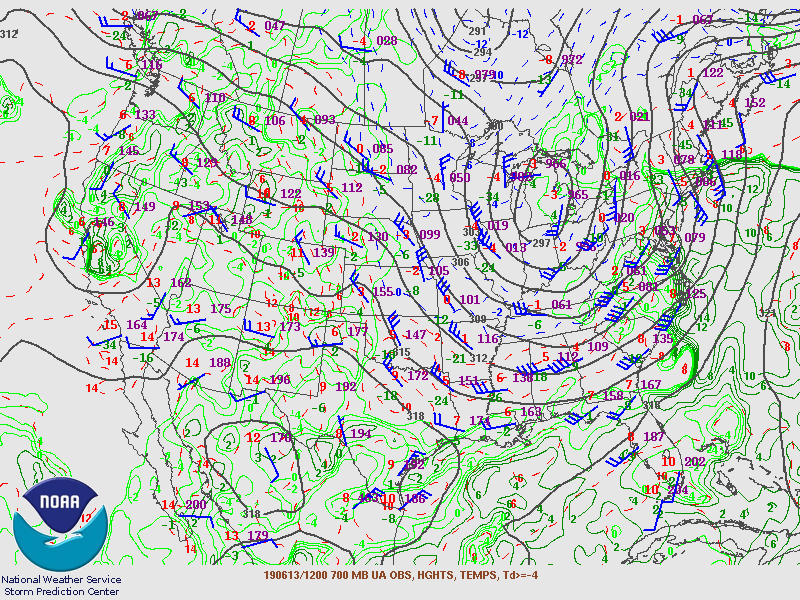
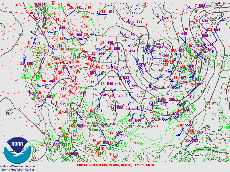
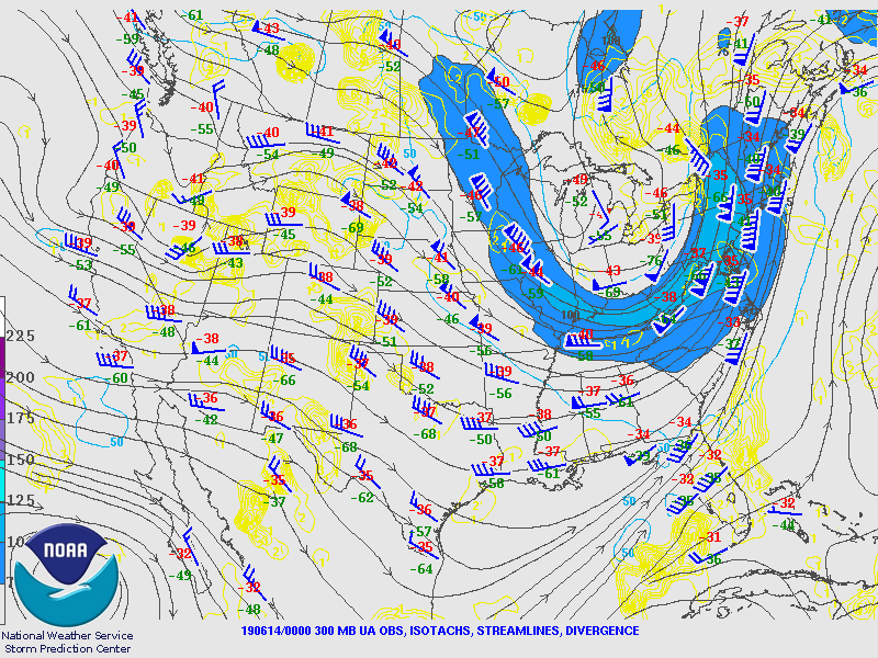
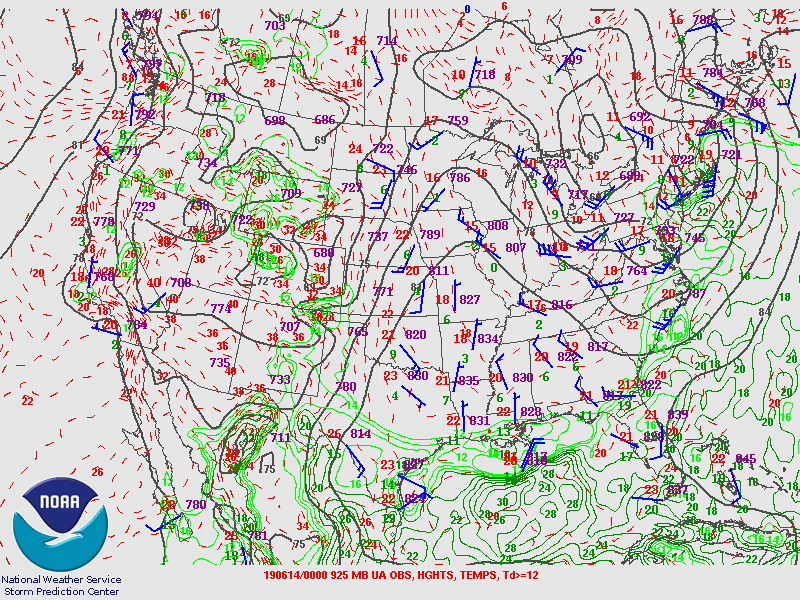
Synoptic Overview at 12z 13 June 2019 (courtesy of SPC)
 |
 |
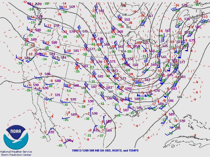 |
| Figure 1: 250-mb analysis | Figure 2: 300-mb analysis | Figure 3: 500-mb analysis |
 |
 |
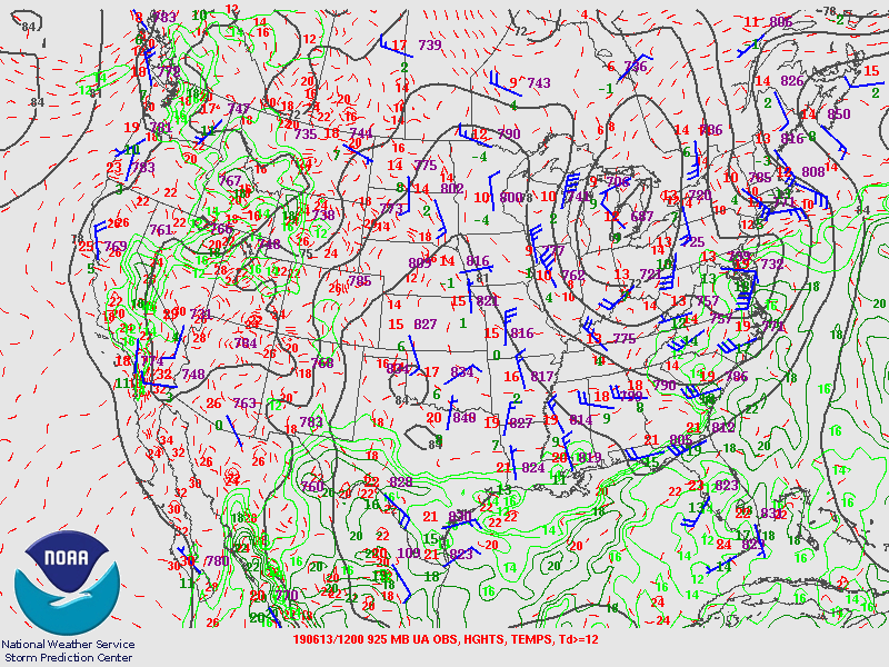 |
| Figure 4: 700-mb analysis | Figure 5: 850-mb analysis | Figure 6: 925-mb analysis |
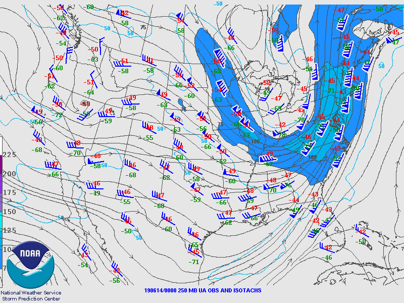
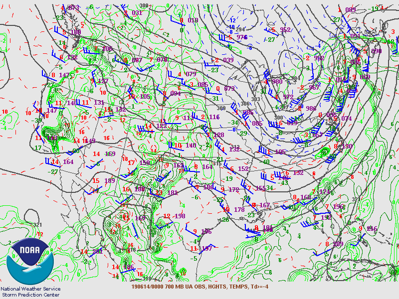
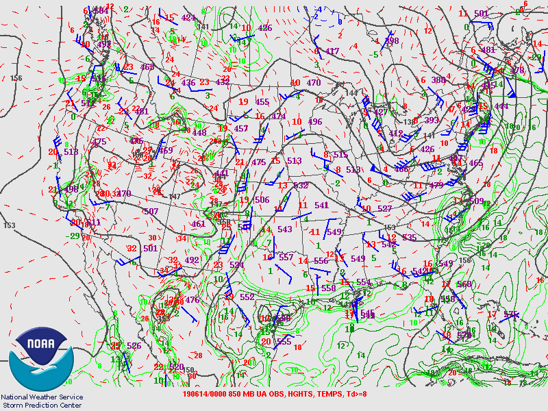
Synoptic Overview at 00z 14 June 2019 (courtesy of SPC)
 |
 |
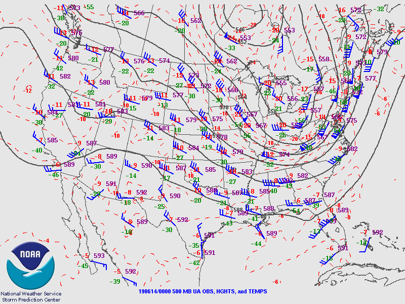 |
| Figure 7: 250-mb analysis | Figure 8: 300-mb analysis | Figure 9: 500-mb analysis |
 |
 |
 |
| Figure 10: 700-mb analysis | Figure 11: 850-mb analysis | Figure 12: 925-mb analysis |
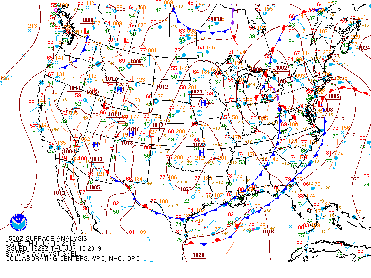
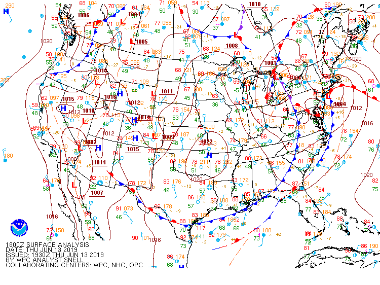
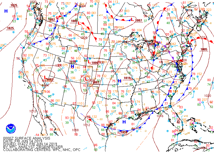
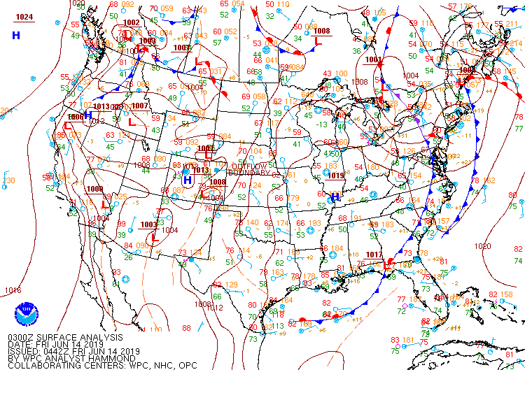
Surface Maps (courtesy of WPC)
 |
 |
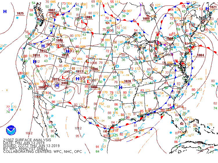 |
| Figure 13: 15z surface map | Figure 14: 18z surface map | Figure 15: 21z surface map |
 |
 |
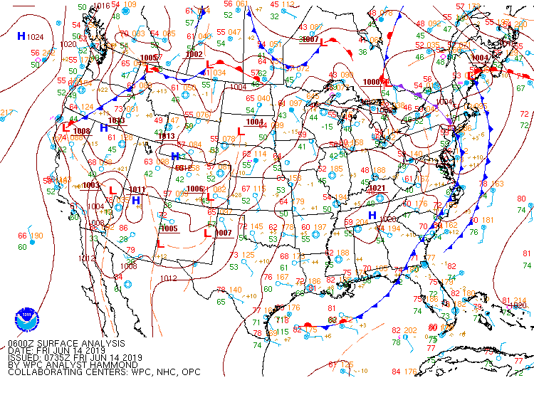 |
| Figure 16: 00z surface map | Figure 17: 03z surface map | Figure 18: 06z surface map |
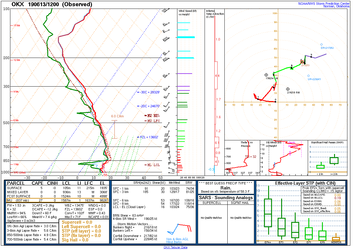 |
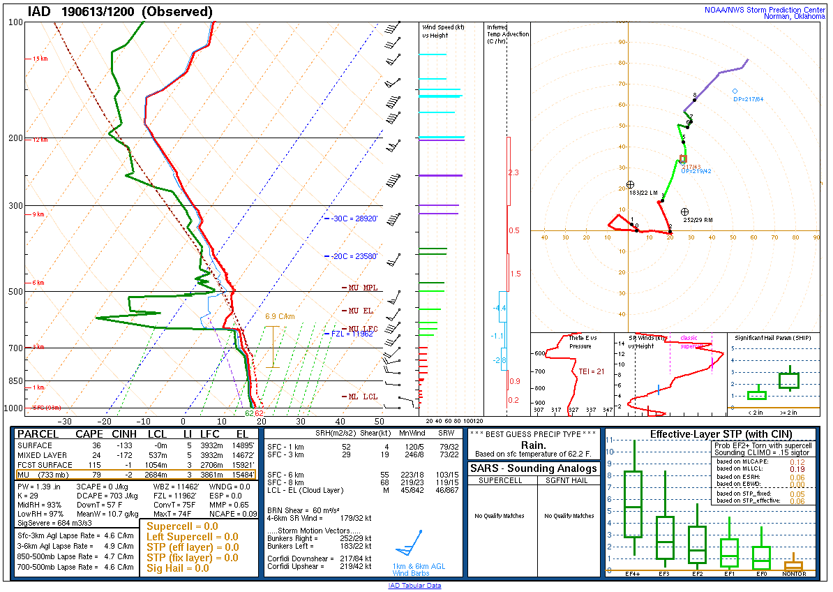 |
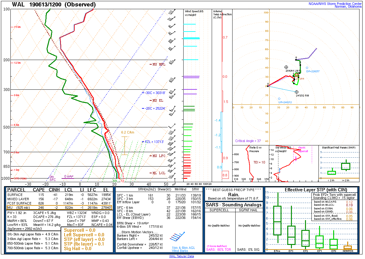 |
| Figure 19: 12z Upton, NY sounding | Figure 20: 12z Sterling, VA sounding | Figure 21: 12z Wallops Island, VA sounding |
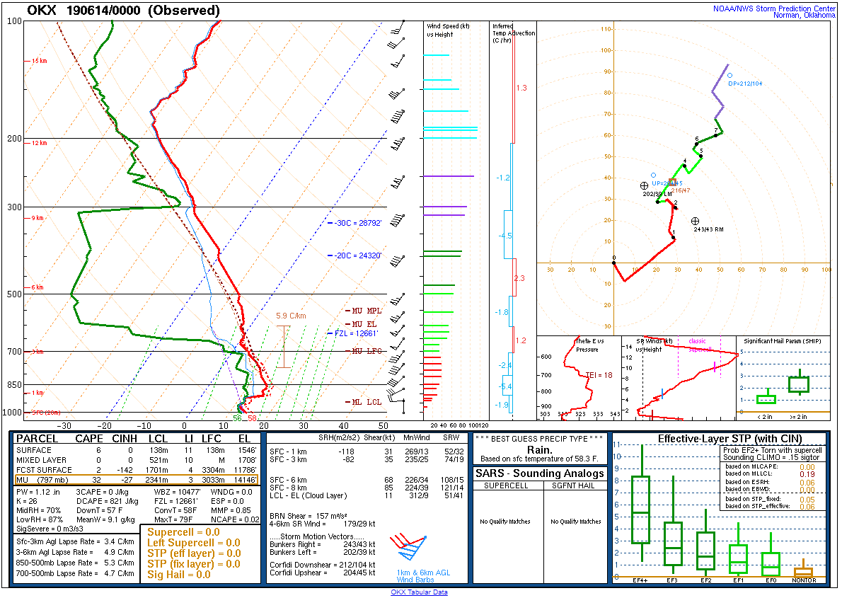 |
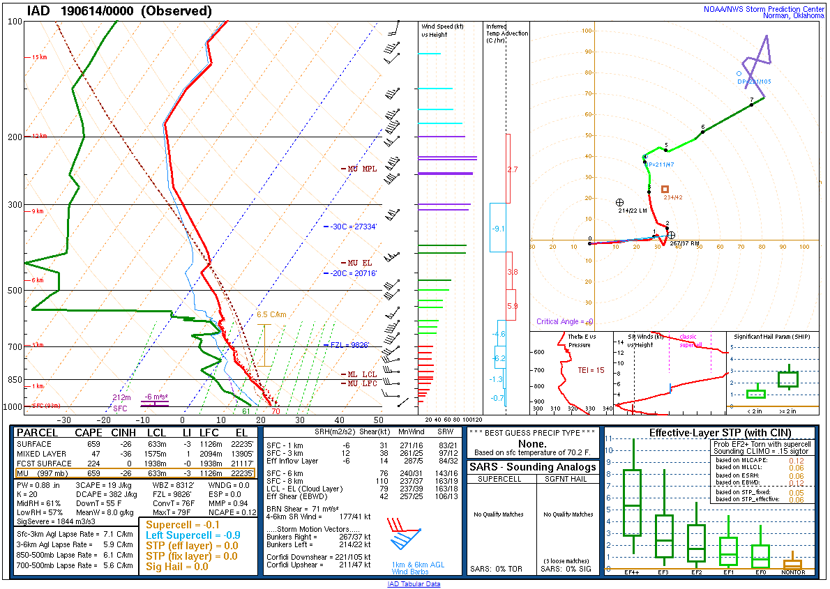 |
 |
| Figure 22: 00z Upton, NY sounding | Figure 23: 00z Sterling, VA sounding | Figure 24: 00z Wallops Island, VA sounding |
 |
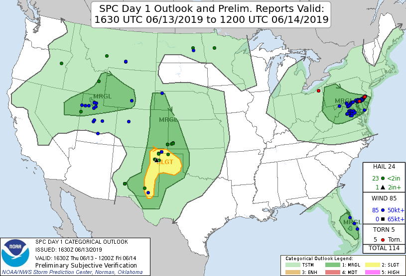 |
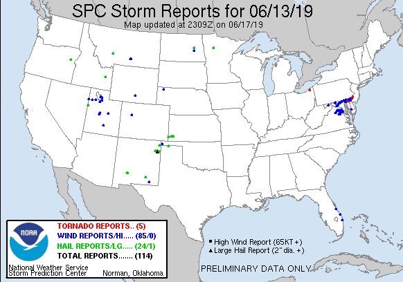
| Figure 1: National Preliminary Reports 12z 13 June 2019 to 12z 14 June 2019 | Figure 2: Prelim Reports vs. 1630z SPC Convective Outlook |
 |
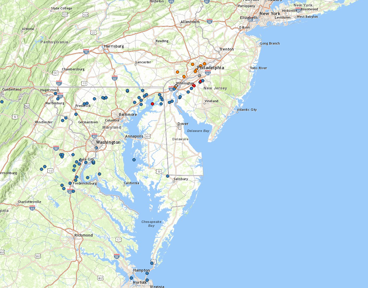 |
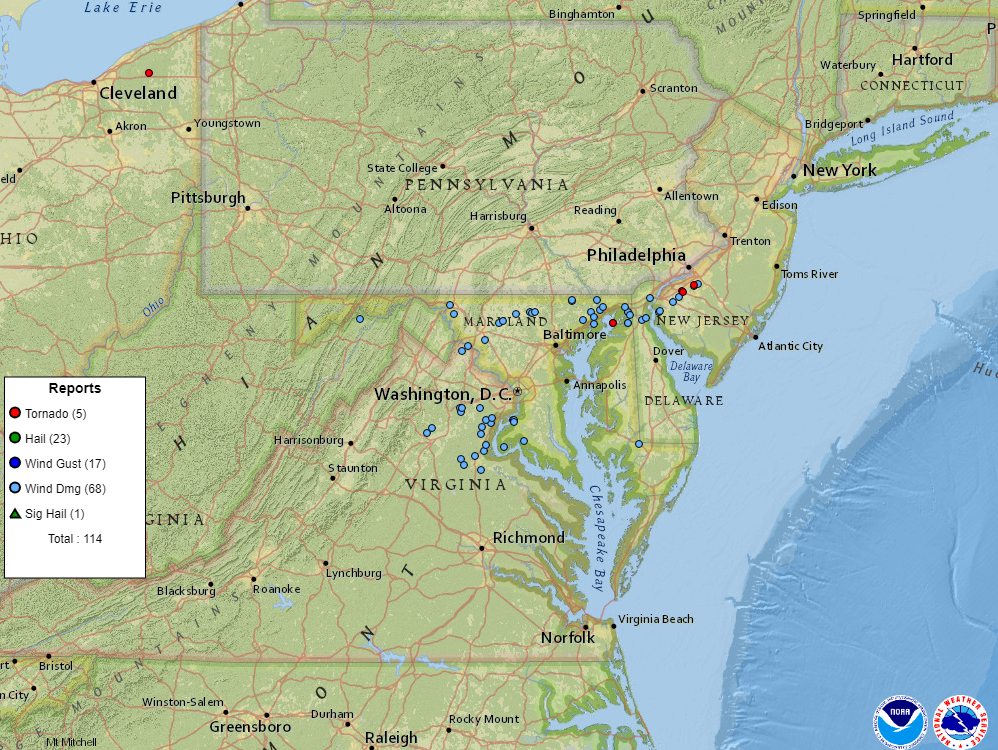
| Figure 3: Zoomed Preliminary Reports for the same period. | Figure 4: Local storm reports (including flooding and non-severe reports) in the region. |
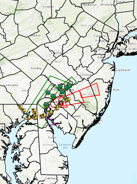 |
| Figure 1: Plot of local storm reports and storm-based warnings for the 13 June 2019 event. Click here for more information. |
NWUS51 KPHI 151003
LSRPHI

PRELIMINARY LOCAL STORM REPORT...SUMMARY
NATIONAL WEATHER SERVICE MOUNT HOLLY NJ
603 AM EDT SAT JUN 15 2019

..TIME...   ...EVENT...      ...CITY LOCATION...     ...LAT.LON...
..DATE...   ....MAG....      ..COUNTY LOCATION..ST.. ...SOURCE....
            ..REMARKS..

0648 PM     TSTM WND DMG     1 SW CONOWINGO          39.67N 76.17W
06/13/2019                   CECIL              MD   DEPT OF HIGHWAYS

            WIND DAMAGE CLOSED U.S. HIGHWAY 1 NORTHBOUND
            AT STATE HIGHWAY 222. TIME ESTIMATED FROM
            RADAR.

0654 PM     TSTM WND DMG     PORT DEPOSIT            39.61N 76.10W
06/13/2019                   CECIL              MD   TRAINED SPOTTER

            SEVERAL REPORTS OF TREES DOWN IN PORT
            DEPOSIT, INCLUDING ONE ACROSS CANAL ROAD,
            FORCING ITS CLOSURE. TIME ESTIMATED FROM
            RADAR.

0702 PM     TORNADO          5 WSW HOLLYWOOD BEACH   39.48N 75.99W
06/13/2019                   CECIL              MD   NWS STORM SURVEY

            A STORM SURVEY DETERMINED AN EF1 TORNADO
            SNAPPED OR UPROOTED HUNDREDS OF TREES IN ELK
            NECK STATE PARK. THE TORNADO LIFTED NEAR
            HOLLYWOOD BEACH.

0704 PM     TSTM WND DMG     4 WSW HOLLYWOOD BEACH   39.48N 75.99W
06/13/2019                   CECIL              MD   DEPT OF HIGHWAYS

            STATE HIGHWAY 272 CLOSED AT CAMPGROUND ROAD
            FROM WIND DAMAGE. TIME ESTIMATED FROM RADAR.

0714 PM     TSTM WND DMG     2 WNW BRANTWOOD         39.57N 75.83W
06/13/2019                   CECIL              MD   PUBLIC

            CORRECTS TIME OF PREVIOUS TSTM WND DMG
            REPORT FROM 2 WNW BRANTWOOD. DOWNED TREE AND
            WIRES WITH PEOPLE TRAPPED IN A HOME. NO
            INJURIES REPORTED. TIME ESTIMATED FROM
            RADAR.

0715 PM     TSTM WND DMG     1 SE CAYOTS             39.48N 75.83W
06/13/2019                   CECIL              MD   PUBLIC

            CORRECTS TIIME OF PREVIOUS TSTM WND DMG
            REPORT FROM 1 SE CAYOTS. NUMEROUS TREES
            DOWN. SEVERAL OUTBUILDINGS DAMAGED. ROOF AND
            WINDOW DAMAGE TO A HOUSE. TIME ESTIMATED
            FROM RADAR.

0715 PM     TSTM WND DMG     2 W ELKTON              39.61N 75.86W
06/13/2019                   CECIL              MD   DEPT OF HIGHWAYS

            WIND DAMAGE CLOSED U.S. HIGHWAY 40 WESTBOUND
            NEAR NOTTINGHAM ROAD. TIME ESTIMATED FROM
            RADAR.

0720 PM     TSTM WND DMG     1 NNE CHESAPEAKE CITY   39.54N 75.81W
06/13/2019                   CECIL              MD   DEPT OF HIGHWAYS

            SEVERAL REPORTS OF WIND DAMAGE NEAR STATE
            HIGHWAY 213 AND BIDDLE STREET. TIME
            ESTIMATED FROM RADAR.

0728 PM     TSTM WND DMG     2 ESE MOUNT PLEASANT    39.50N 75.68W
06/13/2019                   NEW CASTLE         DE   LAW ENFORCEMENT

            WIND GUSTS BLEW OVER A TRACTOR TRAILER NEAR
            THE INTERSECTION OF CEDAR LANE ROAD AND
            BOYDS CORNER ROAD. TIME ESTIMATED FROM
            RADAR.

0733 PM     TSTM WND DMG     2 NNE MCDONOUGH         39.52N 75.63W
06/13/2019                   NEW CASTLE         DE   PUBLIC

            DOWNED TREES AND PARTIAL ROOF DAMAGE NEAR
            THE INTERSECTION OF PORT PENN ROAD AND DUTCH
            NECK ROAD. TIME ESTIMATED FROM RADAR.

0740 PM     TSTM WND DMG     WILMINGTON MANOR        39.69N 75.59W
06/13/2019                   NEW CASTLE         DE   BROADCAST MEDIA

            DOWNED TREEE DAMAGING A HOUSE. TIME
            ESTIMATED FROM RADAR.

0743 PM     TSTM WND DMG     1 W SALEM               39.57N 75.49W
06/13/2019                   SALEM              NJ   PUBLIC

            SEVERAL TREES DOWNED AND UPROOTED. TIME
            ESTIMATED FROM RADAR.

0746 PM     TSTM WND DMG     SALEM                   39.58N 75.48W
06/13/2019                   SALEM              NJ   PUBLIC

            DOWNED TREES AND PARTIAL ROOF DAMAGE NEAR
            THE INTERSECTION OF FRONT STREET AND
            BROADWAY. TIME ESTIMATED FROM RADAR.

0758 PM     FLOOD            CHEYNEY                 39.93N 75.53W
06/13/2019                   CHESTER            PA   TRAINED SPOTTER

            FLOODING ALONG DILWORTHTOWN RD BETWEEN
            WESTOWN RD. AND CREEK RD. FAST MOVING WATER
            SEEN OVER ROADWAY. 1.62 INCHES OF RAIN IN 45
            MINUTES.

0800 PM     TSTM WND DMG     WOODSTOWN               39.65N 75.33W
06/13/2019                   SALEM              NJ   PUBLIC

            MULTIPLE REPORTS OF TREES DOWN. TIME
            ESTIMATED FROM RADAR.

0807 PM     TSTM WND DMG     SOUTH HARRISON TWP      39.70N 75.27W
06/13/2019                   GLOUCESTER         NJ   PUBLIC

            LARGE TREE DOWN AT A RESIDENCE NEAR THE
            INTERSECTION OF STATE HIGHWAY 45 AND COUNTY
            ROAD 694. TIME ESTIMATED FROM RADAR.

0815 PM     TORNADO          1 ESE HARRISON TWP      39.75N 75.24W
06/13/2019                   GLOUCESTER         NJ   NWS STORM SURVEY

            A STORM SURVEY DETERMINED AN EF0 TORNADO
            OCCURRED NEAR MULLICA HILL. CAUSING TREE
            DAMAGE, FENCING DAMAGE TO ONE RESIDENCE AND
            RIPPED A GUTTER OFF ANOTHER RESIDENCE.

0815 PM     FLASH FLOOD      1 NNW CLEARVIEW MANOR   39.72N 75.57W
06/13/2019                   NEW CASTLE         DE   PUBLIC

            SOCIAL MEDIA PHOTOS OF WATER OVER TWO FEET
            DEEP IN SEVERAL RESIDENTIAL AREAS IN THE
            OVERVIEW GARDENS AREA. TIME ESTIMATED FROM
            RADAR REPORTS AND SOCIAL MEDIA POSTS.

0816 PM     TORNADO          MULLICA HILL            39.74N 75.22W
06/13/2019                   GLOUCESTER         NJ   PUBLIC

            VIDEO OF A FUNNEL IN MULLICA HILL WITH SMALL
            DEBRIS BEING LOFTED. TIME ESTIMATED FROM
            RADAR.

0830 PM     TORNADO          2 W BLACKWOOD           39.80N 75.10W
06/13/2019                   GLOUCESTER         NJ   NWS STORM SURVEY

            A TORNADO SKIPPED ALONG A 2.1 MILE PATH FROM
            DEPTFORD TOWNSHIP INTO THE BLACKWOOD SECTION
            OF GLOUCESTER TOWNSHIP, CAUSING SIGNIFICANT
            TREE DAMAGE AND COLLATERAL DAMAGE TO
            RESIDENCES.

0830 PM     TSTM WND DMG     1 N FAIRVIEW            39.79N 75.11W
06/13/2019                   GLOUCESTER         NJ   TRAINED SPOTTER

            DOWNED ROAD SIGN AND NUMEROUS TREE BRANCHES
            DOWN NEAR THE INTERSECTION OF STATE HIGHWAYS
            55 AND 47. TIME ESTIMATED FROM RADAR.

0834 PM     TSTM WND DMG     BLACKWOOD               39.81N 75.06W
06/13/2019                   CAMDEN             NJ   LAW ENFORCEMENT

            NUMEROUS TREES DOWN BETWEEN CHURCH STREET
            AND BLACK HORSE PIKE ALONG ERIAL ROAD. TIME
            ESTIMATED FROM RADAR.

0835 PM     FLASH FLOOD      PENNYPACK CREEK AT PHIL 40.05N 75.03W
06/13/2019                   PHILADELPHIA       PA   OTHER FEDERAL

            THE GAUGE AT PENNYPACK CREEK IN PHILADELPHIA
            REACHED FLOOD STAGE.

0835 PM     FLASH FLOOD      FRANKFORD CREEK AT PHIL 40.02N 75.10W
06/13/2019                   PHILADELPHIA       PA   OTHER FEDERAL

            THE GAUGE AT FRANKFORD CREEK IN PHILADELPHIA
            REACHED FLOOD STAGE.

0900 PM     FLOOD            1 ESE MANTUA            39.96N 75.18W
06/13/2019                   PHILADELPHIA       PA   DEPT OF HIGHWAYS

            FLOODING REPORTED ALONG I-76.

0901 PM     FLOOD            1 WNW POINT BREEZE      39.94N 75.20W
06/13/2019                   PHILADELPHIA       PA   DEPT OF HIGHWAYS

            REPORT OF FLOODING ON I-76.

0907 PM     FLOOD            1 SW SHAWMONT           40.04N 75.25W
06/13/2019                   MONTGOMERY         PA   DEPT OF HIGHWAYS

            FLOODING REPORTED ON I-76.

0946 PM     COASTAL FLOOD    WILMINGTON              39.74N 75.55W
06/13/2019                   NEW CASTLE         DE   DEPT OF HIGHWAYS

            SOUTH MARKET STREET BRIDGE CLOSED FROM TIDAL
            FLOODING.

1015 PM     FLASH FLOOD      CHESTER CREEK NEAR CHES 39.87N 75.41W
06/13/2019                   DELAWARE           PA   OTHER FEDERAL

            THE GAUGE AT CHESTER CREEK NEAR CHESTER
            REACHED FLOOD STAGE.

0203 AM     COASTAL FLOOD    BROOKLAWN               39.88N 75.12W
06/14/2019                   CAMDEN             NJ   DEPT OF HIGHWAYS

            U.S. HIGHWAY 130 CLOSED NEAR COUNTY ROAD 551
            FROM TIDAL FLOODING.


&&

$$

CMS
NOUS41 KPHI 142039
PNSPHI
DEZ001>004-MDZ008-012-015-019-020-NJZ001-007>010-012>027-PAZ054-
055-060>062-070-071-101>106-150845-

Public Information Statement
National Weather Service Mount Holly NJ
439 PM EDT Fri Jun 14 2019

...NWS DAMAGE SURVEY FOR 06/13/2019 STRAIGHT LINE WIND AND
TORNADO EVENT...

.MULLICA HILL TORNADO...

Start Location...Mullica Hill in Gloucester County, New Jersey
End Location...Mullica Hill in Gloucester County, New Jersey
Date...June 13, 2019
Estimated Time...8:15 PM EDT
Maximum EF-Scale Rating...EF0
Estimated Maximum Wind Speed...60-70 mph
Maximum Path Width...50 yards
Path Length...0.3 miles
Beginning Lat/Lon...39.7469/-75.2447
Ending Lat/Lon...39.7500/-75.2402
* Fatalities...0
* Injuries...0

...Summary...
A tornado formed in the development near Saddle Court in Mullica
Hill. This caused damage to fencing at one residence, and ripped a
gutter off another residence. Backyard furniture was lifted
approximately 50 yards. From there, the tornado moved in a
northeasterly direction and caused a narrow path of tree damage
before lifting southwest of Highway 322.

.DEPTFORD TOWNSHIP AND BLACKWOOD TORNADO...

Start Location...Deptford Township in Gloucester County, New Jersey
End Location...Blackwood section of Gloucester Township in Camden County, New Jersey
Date...June 13, 2019
Estimated Time...8:30 to 8:35 PM EDT
Maximum EF-Scale Rating...EF1
Estimated Maximum Wind Speed...90-100 mph
Maximum Path Width...200 yards
Path Length...2.1 miles (non-continuous)
Beginning Lat/Lon...39.8011/-75.0983
Ending Lat/Lon...39.8064/-75.0599
* Fatalities...0
* Injuries...0

...Summary...
The tornado took a non-continuous path from Deptford Township
into the Blackwood section of Gloucester Township. There were
several locations of tree damage, including snapped and uprooted
hardwood trees. There was damage to three residences in Deptford
Township when portions of trees fell on these residences. In
Blackwood, an uprooted tree caused damage to an apartment
building.

.Salem straight line winds...

Location...Salem in Salem County, New Jersey
Date...June 13, 2019
Estimated Time...7:42 PM EDT
Estimated Maximum Wind Speed...60-80 mph
Maximum Path Width...100 yards
Path Length...1.3 miles
Beginning Lat/Lon...39.5711/-75.4903
Ending Lat/Lon...39.5729/-75.4668
* Fatalities...0
* Injuries...0

...Summary...
Straight line winds caused tree damage in and in the vicinity of
Salem. The winds also damaged a garage door and flipped a boat at a
residence on Amwellbury Road.

EF Scale: The Enhanced Fujita Scale classifies tornadoes into the
following categories:

EF0...Weak......65 to 85 mph
EF1...Weak......86 to 110 mph
EF2...Strong....111 to 135 mph
EF3...Strong....136 to 165 mph
EF4...Violent...166 to 200 mph
EF5...Violent...>200 mph

* The information in this statement is preliminary and subject to
change pending final review of the events and publication in NWS
Storm Data.

$$

SJ/JM

---

NOUS41 KPHI 142115
PNSPHI
DEZ001>004-MDZ008-012-015-019-020-NJZ001-007>010-012>027-PAZ054-
055-060>062-070-071-101>106-150915-

Public Information Statement
National Weather Service Mount Holly NJ
515 PM EDT Fri Jun 14 2019

...NWS DAMAGE SURVEY FOR 06/13/19 TORNADO EVENT...

.Elk Neck State Park in Cecil County, MD Tornado...

Start Location...Elk Neck State Park in Cecil County, MD
End Location...Hollywood Beach in Cecil County, MD
Date...June 13, 2019
Estimated Time...7:02 PM EDT to 7:10 PM EDT
Maximum EF-Scale Rating...EF1
Estimated Maximum Wind Speed...100 mph
Maximum Path Width...Approximately 580 yards or one third of a mile
Path Length...7.5 miles
Beginning Lat/Lon...39.4800/-75.9942
Ending Lat/Lon...39.4988/-75.9123
* Fatalities...0
* Injuries...0

...Summary...
A tornado touched down in Elk Neck State Park in southwestern
Cecil County, MD around 7:02 PM on Thursday, June 13. It is
possible this tornado formed offshore as a waterspout which then
came onshore. Hundreds of trees were snapped or uprooted in Elk
Neck State Park in a pattern consistent with tornadic winds. A few
outbuildings also sustained minor damage. The tornado tracked
east-northeastwards towards Hollywood Beach. Only minor damage was
observed in this area, and the tornado is estimated to have
lifted at 7:10 PM. No injuries were reported as a result of this
tornado.

EF Scale: The Enhanced Fujita Scale classifies tornadoes into the
following categories:

EF0...Weak......65 to 85 mph
EF1...Weak......86 to 110 mph
EF2...Strong....111 to 135 mph
EF3...Strong....136 to 165 mph
EF4...Violent...166 to 200 mph
EF5...Violent...>200 mph

* The information in this statement is preliminary and subject to
change pending final review of the event and publication in NWS
Storm Data.

$$

JEO
Gloucester/Camden County Tornadoes and New Castle/Salem County Wind Damage
|
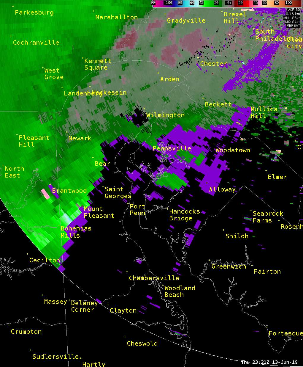 |
| Figure 1: TPHL radar loop of base velocities during the two tornadoes that occurred in Gloucester Counties on the evening of 13 June 2019. The loop is valid from 2356 UTC on 13 June 2019 to 0100 UTC on 14 June 2019. Note the tightening of the rotation (red is outbound; green is inbound) as the broader circulation approaches Mullica Hill. This tighter circulation coincides with the EF0 tornado that developed here. The circulation weakens rather quickly after continuing northward. However, a second circulation rapidly tightens south of Woodbury and continues east-northeast into Camden County (west of Lindenwold). This second circulation is associated with the EF1 tornado that occurred in the Deptford and Blackwood areas. | Figure 2: Same as Fig. 1, valid from 2321 UTC on 13 June 2019 to 0010 UTC on 14 June 2019. In this phase of the event (i.e., before the New Jersey tornadoes), several reports of wind damage very closely correspond to stronger base velocities seen in this radar animation moving from the Bohemia Mills and Mount Pleasant areas eastward to Port Penn. The storm crosses Delaware Bay, entering Salem County near Salem (where several reports of tree and property damage were received) before moving northeastward to Woodstown, which also featured straight-line wind damage. As opposed to the animation in Fig. 1, there is much less evidence of tighter rotation during this phase of the storm and is consistent with storm surveys in Salem County and photos from New Castle County exhibiting characteristics of non-tornadic wind damage. Additional damage was reported in the Wilmington Manor area (south of Wilmington), collocated with stronger base velocities in this area around 2345 UTC. This cell exhibits broader cyclonic rotation after entering New Jersey. |
Cecil County Tornado
 |
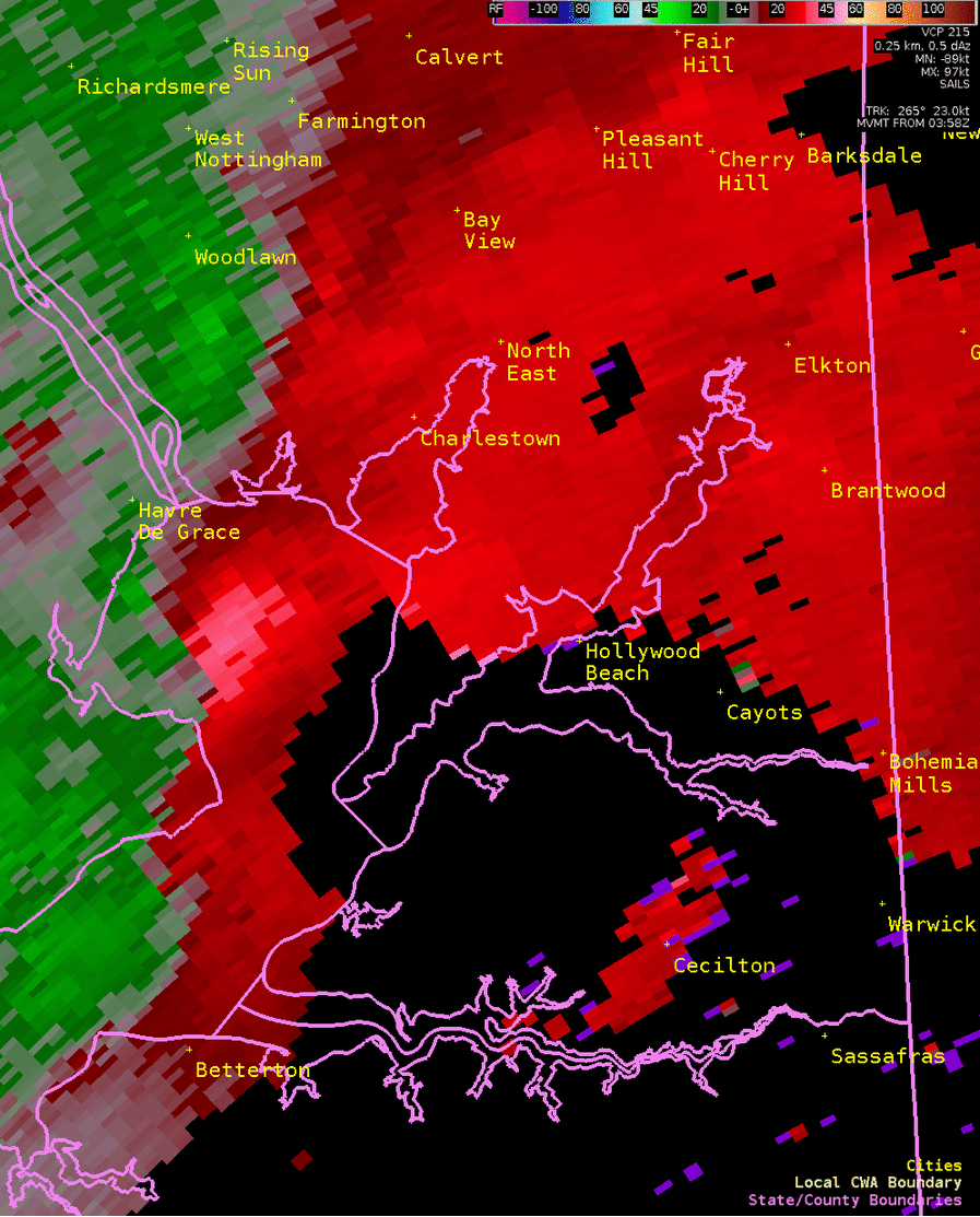 |
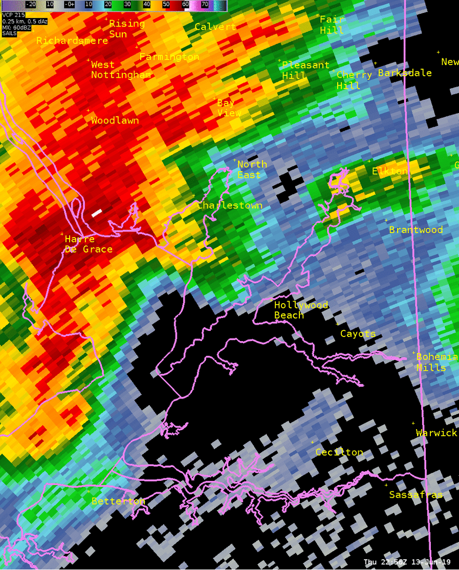
| Figure 3: KDOX radar reflectivity factor animation of the tornadic storm that occurred in Cecil County on 13 June 2019. Animation is from 2256 UTC to 2310 UTC. This line segment featured two areas of damage reports, which are consistent with the portions of the line that begin bowing out toward the end of the animation . One bow is located near North East, and the other is located near Hollywood Beach. Several instances of wind damage occurred along and downstream of the path of these bows. However, a tornado also occurred in the Elk Neck State Park area. There is some indication of a notch in the line segment in this general vicinity (north of Betterton in Chesapeake Bay), which is a a commonly observed location where brief tornadoes occur in storms of this type. | Figure 4: Same as Fig. 3, using base velocities. A close analysis of the animation shows broader rotation beginning in Chesapeake Bay and continuing through southern Cecil County. Notably, however, is a tightening of the rotation observed just prior to landfall. The tornado likely began as a waterspout in Chesapeake Bay. The tighter rotation weakens rapidly after landfall, coinciding with apparent dissipation near Hollywood Beach. |


 Coastal Flood
 Marine Forecasts
 Text Products
 Climate Information
 Skywarn
 Submit Storm Report
 Weather Event Archives
 Forecast Discussion
 Emergency Managers
 Briefing Page