
Numerous severe thunderstorms are expected across a broad region from the Ohio Valley to the Mid-Atlantic and Northeast States today into tonight. Swaths of damaging wind gusts are expected and some tornadoes are possible. Bertha is expected to bring tropical storm conditions to portions of the Gulf Coast from the Florida Panhandle westward to southeastern Louisiana later today and Wednesday. Read More >
Overview
|
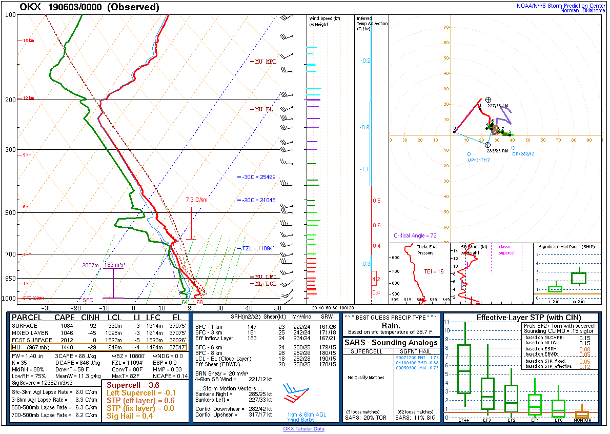
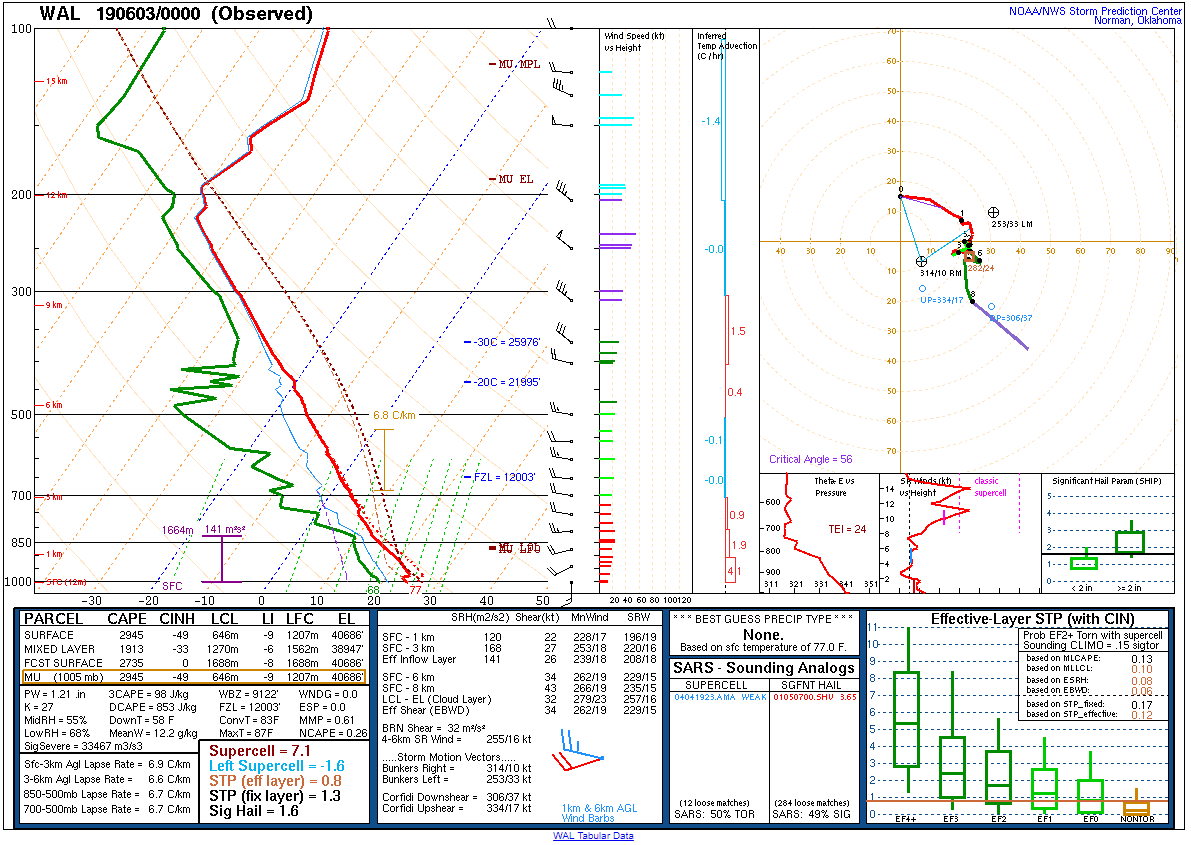
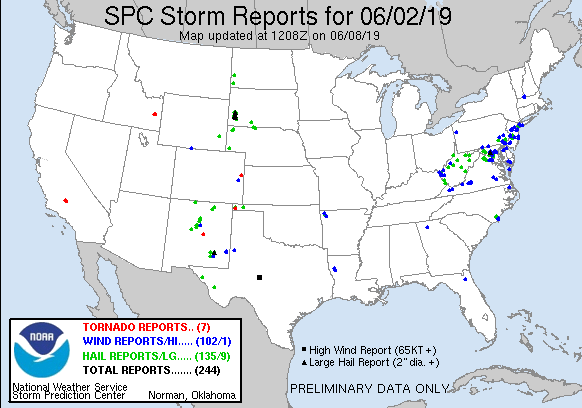
An amplified trough centered in Ontario moved slowly eastward on 2 June 2019, with highly difluent mid/upper flow downstream across the northeastern U.S. Strong diabatic heating contributed to the development of moderate instability during the afternoon across the northern Mid-Atlantic (1000-2000 J/kg MLCAPE). Discrete storms developed rapidly along the I-95 corridor eastward into coastal New Jersey during mid-afternoon, with sufficient deep-layer shear combining with substantial instability to generate strong updrafts producing small to marginally severe hail in several locations across the area. With time, convection began to organize into multicellular clusters and line segments, and the primary severe threat transitioned to damaging winds during the evening hours. Several microbursts were observed across the area, including near Bear and Wilmington Manor in Delaware, the Croydon community in Bucks County in Pennsylvania, and portions of Somerset County in New Jersey. These microbursts produced significant tree damage, with several instances of large trees falling onto and damaging property. Fortunately, no injuries were reported. |
  |
 |
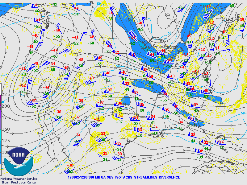
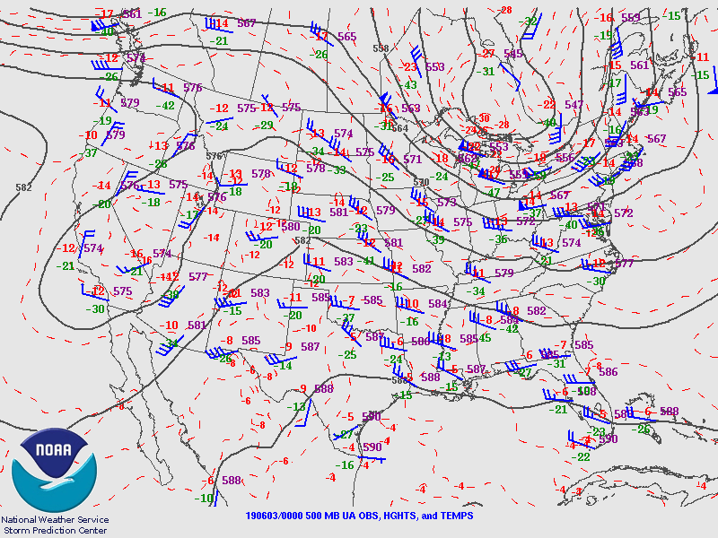
Synoptic Overview at 12z 2 June 2019 (courtesy of SPC)
 |
 |
 |
| Figure 1: 250-mb analysis | Figure 2: 300-mb analysis | Figure 3: 500-mb analysis |
 |
 |
 |
| Figure 4: 700-mb analysis | Figure 5: 850-mb analysis | Figure 6: 925-mb analysis |
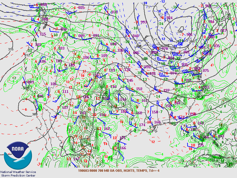
Synoptic Overview at 00z 3 June 2019 (courtesy of SPC)
 |
 |
 |
| Figure 7: 250-mb analysis | Figure 8: 300-mb analysis | Figure 9: 500-mb analysis |
 |
 |
 |
| Figure 10: 700-mb analysis | Figure 11: 850-mb analysis | Figure 12: 925-mb analysis |
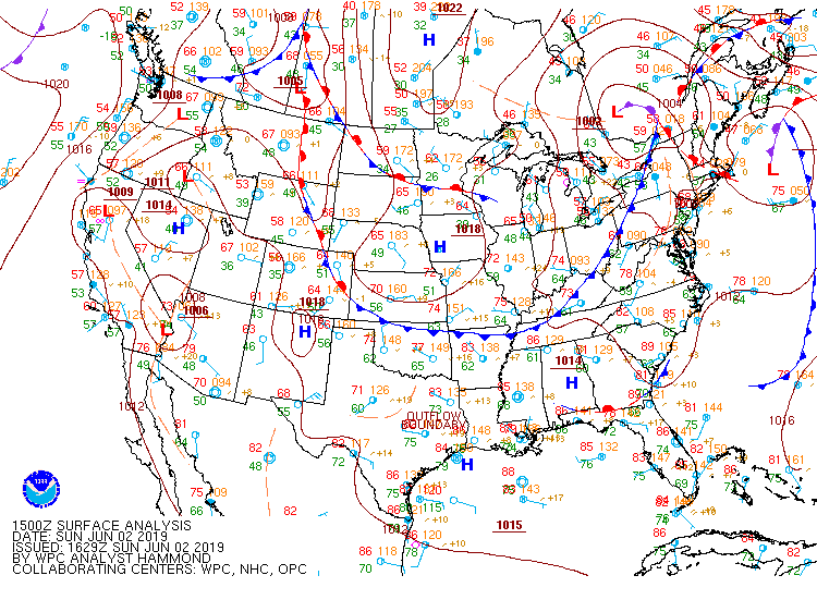
Surface Maps (courtesy of WPC)
 |
 |
 |
| Figure 13: 15z surface map | Figure 14: 18z surface map | Figure 15: 21z surface map |
 |
 |
 |
| Figure 16: 00z surface map | Figure 17: 03z surface map | Figure 18: 06z surface map |
 |
 |
 |
| Figure 19: 12z Pittsburgh, PA sounding | Figure 20: 12z Sterling, VA sounding | Figure 21: 12z Wallops Island, VA sounding |
 |
 |
 |
| Figure 22: 00z Upton, NY sounding | Figure 23: 00z Sterling, VA sounding | Figure 24: 00z Wallops Island, VA sounding |
 |
 |
 |
| Figure 1: National Preliminary Reports 12z 2 June 2019 to 12z 3 June 2019 | Figure 2: Zoomed Preliminary Reports for the same period. | Figure 3: Prelim Reports vs. 1630z SPC Convective Outlook |
 |
| Figure 1: Plot of local storm reports and storm-based warnings for the 2 June 2019 event. Click here for more information. |
NWUS51 KPHI 030750
LSRPHI
PRELIMINARY LOCAL STORM REPORT...SUMMARY
NATIONAL WEATHER SERVICE MOUNT HOLLY NJ
350 AM EDT MON JUN 3 2019
..TIME... ...EVENT... ...CITY LOCATION... ...LAT.LON...
..DATE... ....MAG.... ..COUNTY LOCATION..ST.. ...SOURCE....
..REMARKS..
0246 PM HAIL 2 E WILLOWDALE 39.87N 75.68W
06/02/2019 E0.25 INCH CHESTER PA PUBLIC
MPING REPORT.
0247 PM HAIL KENNETT SQUARE 39.85N 75.71W
06/02/2019 E0.25 INCH CHESTER PA PUBLIC
0303 PM HAIL THORNBURY TWP 39.93N 75.53W
06/02/2019 M0.75 INCH DELAWARE PA TRAINED SPOTTER
0310 PM HAIL AUGUSTINE 39.77N 75.56W
06/02/2019 E0.75 INCH NEW CASTLE DE PUBLIC
UP TO PEA SIZED HAIL REPORTED IN NORTH
WILMINGTON.
0313 PM HAIL 1 N NEWLIN TWP 39.92N 75.70W
06/02/2019 E0.75 INCH CHESTER PA PUBLIC
MPING REPORT.
0319 PM HAIL 1 NE PENNSAUKEN 39.96N 75.06W
06/02/2019 E0.25 INCH CAMDEN NJ PUBLIC
ONE-QUARTER TO ONE-HALF INCH HAIL REPORTED
IN PENNSAUKEN.
0319 PM HAIL GLEN MILLS 39.92N 75.49W
06/02/2019 E1.00 INCH DELAWARE PA PUBLIC
0321 PM HAIL POCOPSON TWP 39.91N 75.64W
06/02/2019 E1.00 INCH CHESTER PA PUBLIC
TIME ESTIMATED FROM RADAR.
0324 PM HAIL PHOENIXVILLE 40.13N 75.51W
06/02/2019 E0.75 INCH CHESTER PA PUBLIC
0326 PM HAIL MOORESTOWN 39.97N 74.94W
06/02/2019 E0.75 INCH BURLINGTON NJ PUBLIC
0329 PM HAIL KING OF PRUSSIA 40.09N 75.38W
06/02/2019 E0.25 INCH MONTGOMERY PA PUBLIC
0330 PM HAIL WEST CHESTER 39.96N 75.60W
06/02/2019 E0.75 INCH CHESTER PA PUBLIC
0330 PM HAIL 2 WNW KING OF PRUSSIA 40.11N 75.42W
06/02/2019 E0.25 INCH MONTGOMERY PA PUBLIC
MPING REPORT.
0335 PM HAIL 2 SSW CHEYNEY 39.91N 75.54W
06/02/2019 E0.25 INCH DELAWARE PA PUBLIC
MPING REPORT.
0337 PM HAIL GLEN MILLS 39.92N 75.49W
06/02/2019 E0.75 INCH DELAWARE PA TRAINED SPOTTER
DIME TO PENNY SIZE HAIL REPORTED IN GLEN
MILLS.
0340 PM HAIL 1 ESE RANCOCAS 40.01N 74.85W
06/02/2019 E0.75 INCH BURLINGTON NJ TRAINED SPOTTER
UP TO PENNY SIZE HAIL REPORTED IN
WILLINGBORO.
0349 PM HAIL LIMA 39.92N 75.44W
06/02/2019 E0.88 INCH DELAWARE PA TRAINED SPOTTER
0350 PM HAIL MEDIA 39.92N 75.38W
06/02/2019 E0.25 INCH DELAWARE PA PUBLIC
0351 PM HAIL NWS MOUNT HOLLY 40.01N 74.82W
06/02/2019 E0.25 INCH BURLINGTON NJ OFFICIAL NWS OBS
PEA SIZED HAIL REPORTED AT THE NWS OFFICE.
0353 PM HAIL GLEN MILLS 39.92N 75.49W
06/02/2019 E0.75 INCH DELAWARE PA PUBLIC
TIME ESTIMATED FROM RADAR.
0355 PM HAIL COLUMBUS 40.08N 74.72W
06/02/2019 E1.00 INCH BURLINGTON NJ PUBLIC
0355 PM HAIL EAST NORRITON 40.16N 75.34W
06/02/2019 E0.25 INCH MONTGOMERY PA PUBLIC
0356 PM HAIL 1 N UPPER DUBLIN TWP 40.17N 75.20W
06/02/2019 E0.25 INCH MONTGOMERY PA PUBLIC
MPING REPORT.
0405 PM HAIL BURLINGTON TWP 40.07N 74.83W
06/02/2019 E0.25 INCH BURLINGTON NJ PUBLIC
0408 PM HAIL WARMINSTER 40.21N 75.10W
06/02/2019 E0.25 INCH BUCKS PA PUBLIC
0414 PM HAIL WYNCOTE 40.09N 75.15W
06/02/2019 E0.25 INCH MONTGOMERY PA PUBLIC
TIME ESTIMATED FROM RADAR.
0415 PM HAIL GLENSIDE 40.10N 75.15W
06/02/2019 E0.25 INCH MONTGOMERY PA PUBLIC
0415 PM HAIL ABINGTON 40.12N 75.13W
06/02/2019 E0.25 INCH MONTGOMERY PA PUBLIC
0417 PM HAIL ABINGTON 40.12N 75.13W
06/02/2019 E0.25 INCH MONTGOMERY PA PUBLIC
0420 PM HAIL NORTHEAST PHILADELPHIA 40.09N 75.02W
06/02/2019 E0.25 INCH PHILADELPHIA PA PUBLIC
TIME ESTIMATED FROM RADAR.
0423 PM HAIL MANAHAWKIN 39.69N 74.26W
06/02/2019 M0.75 INCH OCEAN NJ TRAINED SPOTTER
0428 PM HAIL SOMERTON 40.12N 75.01W
06/02/2019 E0.25 INCH PHILADELPHIA PA PUBLIC
0430 PM HAIL 1 NE SOMERTON 40.13N 75.00W
06/02/2019 E0.25 INCH BUCKS PA PUBLIC
MPING REPORT.
0434 PM HAIL 1 ENE LOWER MAKEFIELD T 40.23N 74.83W
06/02/2019 E0.25 INCH BUCKS PA PUBLIC
MPING REPORT.
0440 PM HAIL 2 WSW EWING 40.26N 74.83W
06/02/2019 E0.25 INCH MERCER NJ PUBLIC
0440 PM HAIL 3 S CLARKSBURG 40.15N 74.44W
06/02/2019 E0.25 INCH MONMOUTH NJ PUBLIC
0500 PM HAIL BARNEGAT 39.75N 74.22W
06/02/2019 M0.50 INCH OCEAN NJ TRAINED SPOTTER
0500 PM HAIL TUCKERTON 39.60N 74.34W
06/02/2019 E0.75 INCH OCEAN NJ PUBLIC
0602 PM HAIL LINCOLN UNIVERSITY 39.80N 75.92W
06/02/2019 M0.75 INCH CHESTER PA PUBLIC
0608 PM HAIL 1 SE NEW LONDON TWP. 39.78N 75.86W
06/02/2019 E0.25 INCH CHESTER PA PUBLIC
MPING REPORT.
0614 PM HAIL 1 S WEST GROVE 39.80N 75.83W
06/02/2019 E0.25 INCH CHESTER PA COCORAHS
0616 PM TSTM WND DMG WEST GROVE 39.82N 75.82W
06/02/2019 CHESTER PA COUNTY OFFICIAL
DOWNED TREES NEAR AND ON THE RAILROAD TRACKS
NEAR RAILROAD AVENUE AND OAKLAND AVENUE.
TIME ESTIMATED FROM RADAR.
0619 PM HAIL 1 SE WEST GROVE 39.81N 75.81W
06/02/2019 E0.25 INCH CHESTER PA TRAINED SPOTTER
0630 PM HAIL 2 S ODESSA 39.43N 75.66W
06/02/2019 E0.25 INCH NEW CASTLE DE PUBLIC
MPING REPORT.
0636 PM TSTM WND DMG WOODSHADE 39.65N 75.69W
06/02/2019 NEW CASTLE DE PUBLIC
DOWNED WIRES ON CEDAR RIDGE COURT. TIME
ESTIMATED FROM RADAR.
0639 PM TSTM WND DMG 2 E WOODSHADE 39.65N 75.65W
06/02/2019 NEW CASTLE DE PUBLIC
TREES DOWN AT THE CHRISTIANA MEADOWS
APARTMENT COMPLEX.
0645 PM TSTM WND DMG 1 E MIDVALE 39.66N 75.60W
06/02/2019 NEW CASTLE DE PUBLIC
REPORT OF WIRES DOWN ON DUPONT HIGHWAY NEAR
WILMINGTON MANOR. TIME ESTIMATED FROM RADAR.
0645 PM TSTM WND GST 4 SSW ELSINBORO TWP 39.48N 75.54W
06/02/2019 M56 MPH SALEM NJ MESONET
LOWER ALLOWAYS CREEK MESONET STATION.
0647 PM HAIL WILMINGTON 39.75N 75.56W
06/02/2019 E1.00 INCH NEW CASTLE DE TRAINED SPOTTER
DIME TO QUARTER SIZE HAIL REPORTED IN
WILMINGTON.
0647 PM TSTM WND DMG 1 SW MIDVALE 39.65N 75.62W
06/02/2019 NEW CASTLE DE DEPT OF HIGHWAYS
DOWNED WIRES HAVE CLOSED U.S. HIGHWAY 13
SOUTH OF U.S. HIGHWAY 40. TIME ESTIMATED
FROM RADAR.
0652 PM HAIL MONROE PARK 39.78N 75.53W
06/02/2019 M1.00 INCH NEW CASTLE DE TRAINED SPOTTER
0653 PM HAIL CARRCROFT 39.78N 75.50W
06/02/2019 E0.75 INCH NEW CASTLE DE PUBLIC
OBSERVED AT BELLEVUE STATE PARK.
0654 PM TSTM WND DMG 1 ENE BRECKNOCK TWP. 40.24N 75.97W
06/02/2019 BERKS PA FIRE DEPT/RESCUE
REPORTS OF TREES DOWN ON GILL ROAD, KURTZ
MILL ROAD, AND CANDY ROAD IN BRECKNOCK TWP.
TIME ESTIMATED FROM RADAR.
0654 PM HAIL 1 N NEW MORGAN 40.21N 75.89W
06/02/2019 M0.25 INCH BERKS PA COCORAHS
0655 PM TSTM WND GST READING REGIONAL AIRPOR 40.37N 75.96W
06/02/2019 M48 MPH BERKS PA ASOS
0705 PM TSTM WND GST 1 WNW CEDARVILLE 39.63N 75.36W
06/02/2019 M46 MPH SALEM NJ MESONET
NJWXNET GAUGE.
0715 PM TSTM WND GST POTTSTOWN 40.25N 75.65W
06/02/2019 E50 MPH MONTGOMERY PA TRAINED SPOTTER
ESTIMATED 40 TO 50 MPH WIND GUST. TIME
ESTIMATED FROM RADAR.
0715 PM HAIL POTTSTOWN 40.25N 75.65W
06/02/2019 M0.25 INCH MONTGOMERY PA TRAINED SPOTTER
0717 PM TSTM WND DMG 1 ESE UPPER PITTSGROVE 39.61N 75.22W
06/02/2019 SALEM NJ DEPT OF HIGHWAYS
U.S. HIGHWAY 40 CLOSED BETWEEN STATE HIGHWAY
77 AND COUNTY ROAD 648 OWING TO DOWNED POWER
CABLES. TIME ESTIMATED FROM RADAR.
0722 PM TSTM WND DMG 3 E GILBERTSVILLE 40.31N 75.54W
06/02/2019 MONTGOMERY PA PUBLIC
MPING REPORT OF TREES AND POWER LINES DOWN.
TIME ESTIMATED FROM RADAR.
0725 PM HAIL GILBERTSVILLE 40.32N 75.61W
06/02/2019 M0.25 INCH MONTGOMERY PA TRAINED SPOTTER
0729 PM HAIL 2 SW CLAYTON 39.64N 75.12W
06/02/2019 E0.25 INCH GLOUCESTER NJ PUBLIC
MPING REPORT.
0730 PM TSTM WND DMG FRANKLINVILLE 39.62N 75.08W
06/02/2019 GLOUCESTER NJ FIRE DEPT/RESCUE
SEVERAL TREES AND POWER LINES DOWN. TIME
ESTIMATED FROM RADAR.
0732 PM HAIL SEWELL 39.77N 75.15W
06/02/2019 E0.25 INCH GLOUCESTER NJ TRAINED SPOTTER
0737 PM TSTM WND DMG 3 E CHURCH HILL 39.14N 75.93W
06/02/2019 QUEEN ANNES MD DEPT OF HIGHWAYS
U.S. HIGHWAY 301 CLOSED AT STATE HIGHWAY 302
FROM WIND DAMAGE AND DEBRIS. TIME ESTIMATED
FROM RADAR.
0737 PM HAIL PINE HILL 39.79N 74.99W
06/02/2019 E0.25 INCH CAMDEN NJ PUBLIC
0738 PM HAIL 2 SSW MONROE TWP 39.63N 74.98W
06/02/2019 E0.25 INCH GLOUCESTER NJ PUBLIC
MPING REPORT.
0740 PM HAIL UPPER SALFORD TWP 40.29N 75.45W
06/02/2019 E0.25 INCH MONTGOMERY PA PUBLIC
0741 PM HAIL WILLIAMSTOWN 39.69N 75.00W
06/02/2019 M0.50 INCH GLOUCESTER NJ TRAINED SPOTTER
0743 PM HAIL 2 ESE MEDFORD LAKES 39.85N 74.77W
06/02/2019 E1.00 INCH BURLINGTON NJ TRAINED SPOTTER
0745 PM HAIL 1 SW MEDFORD LAKES 39.85N 74.81W
06/02/2019 E0.25 INCH BURLINGTON NJ PUBLIC
MPING REPORT.
0746 PM HAIL FRANCONIA TWP 40.30N 75.36W
06/02/2019 E0.25 INCH MONTGOMERY PA PUBLIC
0756 PM TSTM WND DMG 2 ENE KENTON 39.24N 75.63W
06/02/2019 KENT DE PUBLIC
REPORT OF DOWNED WIRES ON MASSEYS MILLPOND
ROAD IN SMYRNA. TIME ESTIMATED FROM RADAR.
0758 PM HAIL 2 NW CHESWOLD 39.24N 75.61W
06/02/2019 E0.75 INCH KENT DE PUBLIC
TIME AND LOCATION APPROXIMATED.
0800 PM TSTM WND DMG CROYDON 40.09N 74.90W
06/02/2019 BUCKS PA PUBLIC
TREES DOWN INCLUDING ONE LARGE TREE
UPROOTED. PART OF A ROOF PEELED OFF OF A
BUILDING. TIME ESTIMATED FROM RADAR.
0802 PM HAIL 1 SSE BENSALEM 40.10N 74.92W
06/02/2019 E0.25 INCH BUCKS PA PUBLIC
MPING REPORT.
0805 PM TSTM WND DMG BRISTOL TWP 40.12N 74.87W
06/02/2019 BUCKS PA FIRE DEPT/RESCUE
SEVERAL REPORTS OF TREES DOWN AROUND THE AREA, A FEW
OF WHICH FELL ON HOUSES, MAINLY IN THE CROYDON COMMUNITY.
RAMP RESTRICTIONS AT EXIT 37 OF INTERSTATE 95 AT STATE
HIGHWAY 132 ARE IN PLACE FROM DOWNED TREES. TIME ESTIMATED
FROM RADAR.
0815 PM TSTM WND DMG BROWNS MILLS 39.97N 74.58W
06/02/2019 BURLINGTON NJ PUBLIC
DELAYED REPORT. LARGE TREES DOWN AT A FEW
RESIDENCES. TIME ESTIMATED FROM RADAR.
0818 PM MARINE TSTM WIND 6 ESE WOODLAND BEACH 39.31N 75.38W
06/02/2019 M43 MPH ANZ430 DE MESONET
SHIP JOHN SHOAL NOS GAUGE.
0834 PM MARINE TSTM WIND 2 E WARETOWN 39.79N 74.17W
06/02/2019 M61 MPH ANZ451 NJ MESONET
WEATHERFLOW GAUGE.
0834 PM TSTM WND GST WARETOWN 39.79N 74.20W
06/02/2019 M61 MPH OCEAN NJ MESONET
0840 PM TSTM WND DMG 2 NW MILLSTONE 40.52N 74.61W
06/02/2019 SOMERSET NJ PUBLIC
SOME TREES DOWN WHICH TOOK DOWN WIRES ON A
PORTION OF SUNNYMEADE ROAD IN HILLSBOROUGH.
TIME ESTIMATED FROM RADAR.
0844 PM HAIL 2 WSW FOLSOM 39.59N 74.88W
06/02/2019 E0.25 INCH ATLANTIC NJ PUBLIC
MPING REPORT.
0844 PM TSTM WND GST 2 N BARNEGAT LIGHT 39.78N 74.11W
06/02/2019 M56 MPH OCEAN NJ MESONET
0845 PM TSTM WND GST 2 SSW SEASIDE PARK 39.91N 74.09W
06/02/2019 M58 MPH OCEAN NJ MESONET
CWOP SENSOR.
0846 PM MARINE TSTM WIND 1 E BARNEGAT LIGHT 39.76N 74.09W
06/02/2019 M44 MPH ANZ451 NJ MESONET
WEATHERFLOW GAUGE.
0847 PM TSTM WND DMG 2 WSW MANVILLE 40.54N 74.62W
06/02/2019 SOMERSET NJ PUBLIC
DOWNED TREE ON U.S. HIGHWAY 206 SOUTH OF
BROOKS BLVD. ALL LANES CLOSED. TIME
ESTIMATED FROM RADAR.
0853 PM TSTM WND DMG 1 S SOUTH BOUND BROOK 40.55N 74.53W
06/02/2019 SOMERSET NJ PUBLIC
TREE INTO A HOUSE AND WIRES DOWN ON MAPLE
AVENUE IN FRANKLIN TWP. TIME ESTIMATED FROM
RADAR.
0856 PM MARINE TSTM WIND 2 W BRICK 40.01N 74.09W
06/02/2019 M41 MPH ANZ451 NJ MESONET
WEATHERFLOW GAUGE.
0910 PM HAIL MATAWAN 40.41N 74.23W
06/02/2019 E0.25 INCH MONMOUTH NJ PUBLIC
0920 PM TSTM WND DMG 1 WNW HAZLET 40.43N 74.20W
06/02/2019 MONMOUTH NJ DEPT OF HIGHWAYS
DOWNED TREE ON NJ 36 NORTHBOUND IN THE AREA
OF MAIN STREET. ALL LANES CLOSED. TIME
ESTIMATED FROM RADAR.
0927 PM MARINE TSTM WIND 1 WNW MONMOUTH BEACH 40.34N 73.99W
06/02/2019 M45 MPH MONMOUTH NJ MESONET
WEATHERFLOW GAUGE.
0936 PM TSTM WND GST 2 S SANDY HOOK 40.45N 74.00W
06/02/2019 M58 MPH MONMOUTH NJ C-MAN STATION
0942 PM MARINE TSTM WIND 5 SE MYSTIC ISLAND 39.51N 74.32W
06/02/2019 M47 MPH OCEAN NJ MESONET
HADS SENSOR.
0945 PM MARINE TSTM WIND 4 SE MYSTIC ISLAND 39.52N 74.32W
06/02/2019 M44 MPH OCEAN NJ MESONET
WEATHERFLOW GAUGE.
0946 PM MARINE TSTM WIND 2 SSE TUCKERTON 39.58N 74.32W
06/02/2019 M43 MPH ANZ451 NJ MESONET
0946 PM MARINE TSTM WIND 2 SW BEACH HAVEN 39.54N 74.26W
06/02/2019 M43 MPH OCEAN NJ MESONET
&&
$$
CMS/GORSE
Microburst in Croydon, PA (GR2Analyst and AWIPS)
 |
 |
| Figure 1: Loop of KDIX radar reflectivity factor (top left), base velocity (top right), correlation coefficient (bottom left), and differential reflectivity (bottom right) from 2353 UTC 2 June 2019 to 0007 UTC 3 June 2019. An area of stronger radar reflectivity factor moves over the Croydon area during this time, coinciding with the reported wind damage to the area (including numerous trees down and property damage). However, the presentation on radar is not overly suggestive of such a strong microburst. A primary reason for this is that the storm is traveling generally perpendicular to the direction of the radar pulse. Thus, the base velocities measured by the radar (which only measure velocities parallel to the beam) are fairly low (generally below 25 kts). Detection of severe winds is much more difficult with storms moving perpendicular to the radar pulse. Additionally, storms on this evening were low-topped (i.e., did not extend high into the atmosphere), which makes identification of severe storms more difficult as well. | Figure 2: Loop of TPHL base velocities from 2353 UTC 2 June 2019 to 0001 UTC 3 June 2019. The Philadelphia Terminal Doppler radar is located in western New Jersey across the Delaware River from Philadelphia International Airport. In this case, the radar detects the Croydon microburst far better, since the winds are generally parallel to the radar pulse. Measured velocities here are above 50 kts around 750 feet above ground level (AGL), a strong suggestion of a severe storm. |
 |
 |
| Figure 3: Cross section of the Croydon microburst using KDIX radar reflectivity factor valid at 2348 UTC (top left), 2353 UTC (top right), 2359 UTC (bottom left), and 0004 UTC (bottom right) 2-3 June 2019. The highest reflectivities are tilted (generally toward the east) with height, but the strongest cores generally reach around 10,000 feet AGL, an indication of the low-topped nature to the convection. However, the storm did have >50 dBZ echoes to around 20,000 feet AGL shortly before the microburst occurred (not shown). There is a general appearance of the strongest echo descending with time, indicative of a downdraft reaching the surface (overwhelming the updraft). | Figure 4: Same as Fig. 1, valid at the 6.4 degree elevation angle (around 17,000 feet AGL near Croydon) at 0003 UTC 3 June 2019. There is a core of 60+ dBZ radar reflectivity factor at this level, suggesting a strong updraft is lofting rain and hail to this level. This is one of the indications this storm was at least capable of producing severe weather. |
Delaware Severe Storms (GR2Analyst)
 |
 |
| Figure 5: Same as Fig. 1, using KDOX and valid from 2229 UTC to 2247 UTC on 2 June 2019. Similar to the Croydon microburst, the storm's motion in this case was generally easterly. This is perpendicular to the direction of the radar pulse from KDOX (located at Dover Air Force Base). As such, base velocities are once again rather low and not overly suggestive of a severe storm. However, note the tendency for the storm to bow (bend eastward) with time. This is an indication of strong winds reaching the surface, forcing the storm forward faster where the strongest winds are occurring. | Figure 6: Same as Fig. 5, valid from 2351 UTC 2 June 2019 to 0001 UTC 3 June 2019. This storm was a little easier to diagnose as severe, as its radar reflectivity factor was much higher than other convective cores that produced wind damage during the event. Hail to the size of pennies was reported with this storm, as well as wind damage in a swath from Queen Anne's County in Maryland to the Kent County shores of Delaware Bay. The most significant damage was reported in Kenton, which was well-timed with the storm exhibiting its highest radar reflectivities. This storm also featured a three-body scatter spike (low CC to the northwest of the storm) and bowing characteristics. Note that base velocities are once again fairly low, owing to the storm's track perpendicular to the radar pulse. |
Somerset County Microburst (GR2Analyst)
 |
| Figure 7: Same as Fig. 1, valid from 0039 to 0053 UTC on 3 June 2019. Here is another instance of a microburst generally occurring perpendicular to the radar pulse. There is some hint of bowing with this storm at the time wind damage was reported near Manville and South Bound Brook. Note also that radar reflectivity factor was above 60 dBZ at times near and just northwest of the bowed portion of the storm. These are subtle indications the storm may be producing damaging winds. In this case, the Terminal Doppler radar from Newark, NJ (TEWR), identified stronger winds close to the surface (not shown). |
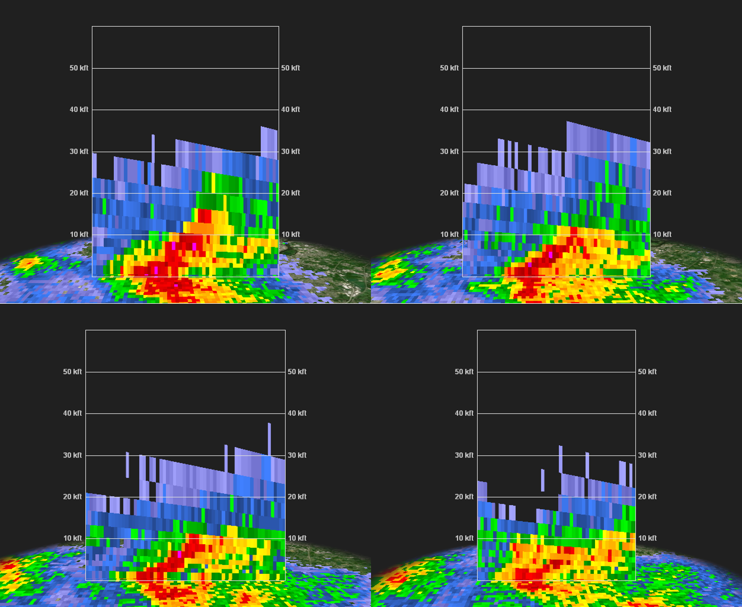
Pocopson Large Hail (GR2Analyst)
 |
 |
| Figure 8: Same as Fig. 1, valid from 2210 to 2221 UTC on 2 June 2019. Before the storms became primarily wind-damage producers, they generated a lot of hail across the area. Hail up to quarter size was observed with this storm in Chester County, in Pocopson Twp. Radar indicated a three-body scatter spike with this storm (note the very low CC and varying ZDR extending west of the storm); this is strongly indicative of large hail. The storm also exhibits a slight right turn during the animation (fairly common with supercells). Hail sizes were generally kept to around one inch in diameter or less because of two factors: (1) Most of the instability was in the layer of air above freezing, and (2) the depth of above-freezing air was substantial (generally above 10,000-12,000 feet). Thus, although the storms generated a lot of hail, hailstones melted considerably before reaching the surface. | Figure 9: Cross section of the Pocopson hail storm, using KDIX radar reflectivity factor valid at 2210 UTC (left) and 2228 UTC (right) on 2 June 2019. The relatively deep layer of >60 dBZ radar reflectivity factor at 2210 UTC indicated an intense storm producing large hail. However, the storm was ultimately collapsing twenty minutes later, as indicated by the much shallower nature of the high reflectivity at 2228 UTC. This was a common characteristic of storms during the afternoon. They became briefly intense, producing small to marginally severe hail. Then, the storm weakened as the downdraft overwhelmed the updraft (an indication that shear was probably too weak to maintain separation between updrafts and downdrafts). In this case, a new updraft appeared to be developing on its west side. Indeed, a new storm developed and produced small hail a few minutes later. |


 Coastal Flood
 Marine Forecasts
 Text Products
 Climate Information
 Skywarn
 Submit Storm Report
 Weather Event Archives
 Forecast Discussion
 Emergency Managers
 Briefing Page