
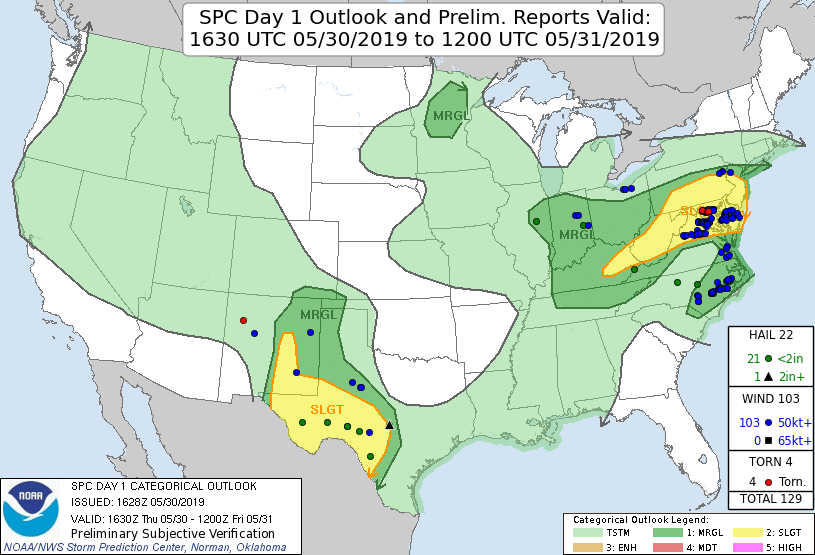
A heat wave over the Southwest will intensify this week, peaking and expanding into the Intermountain West and northern High Plains this weekend. Critical to extremely critical fire weather conditions are forecast from the Northwest and the northern Great Basin this weekend. Particularly Dangerous Situation Red Flag Warnings have been issued. Read More >
Overview
|
The last of a three-day period of severe weather in the National Weather Service Mount Holly county warning area (CWA) occurred on 30 May 2019. A low-amplitude shortwave trough in the Great Lakes region approached the northern Mid-Atlantic during the afternoon and evening hours, with fast midlevel flow downstream aiding in strong deep-layer shear. However, antecedent convection on 28-29 May weakened midlevel lapse rates sufficiently to lower the significant severe threat that existed the prior two days. Nevertheless, sufficient heating downstream of the aforementioned shortwave trough allowed for clusters of storms to develop from Pennsylvania southward to Virginia. A small but potent mesoscale convective system (MCS) developed near the DC area and spread eastward through Delmarva during the late afternoon hours. Widespread damaging winds were observed, with substantial tree damage in Caroline County in Maryland and Sussex County in Delaware reported. Meanwhile, in eastern Pennsylvania and New Jersey, instability was meager (limiting the severe-weather threat), but the environment proved favorable for heavy rainfall. Several instances of flooding were reported from Northampton County eastward to Morris and Somerset Counties in New Jersey. 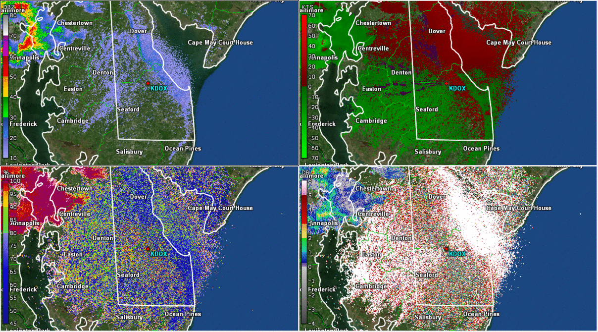 Composite radar loop of the Delmarva mesoscale convective system on 30 May 2019. |
 Tree and roof damage near Milford, DE. Photo courtesy Lynn Wilkins. |
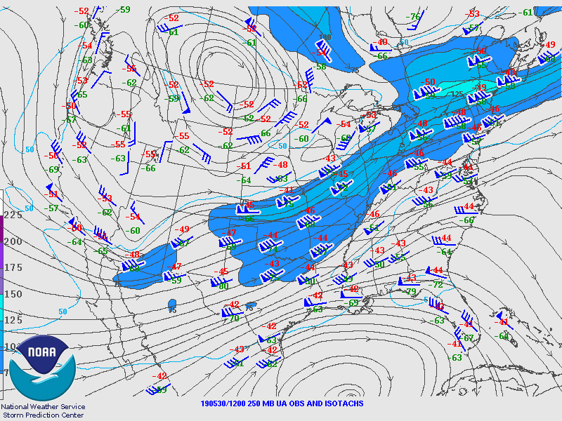
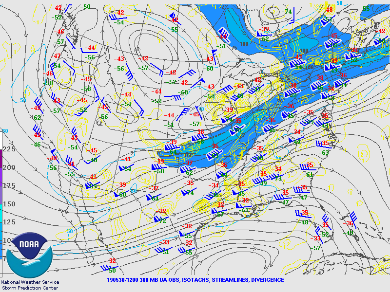
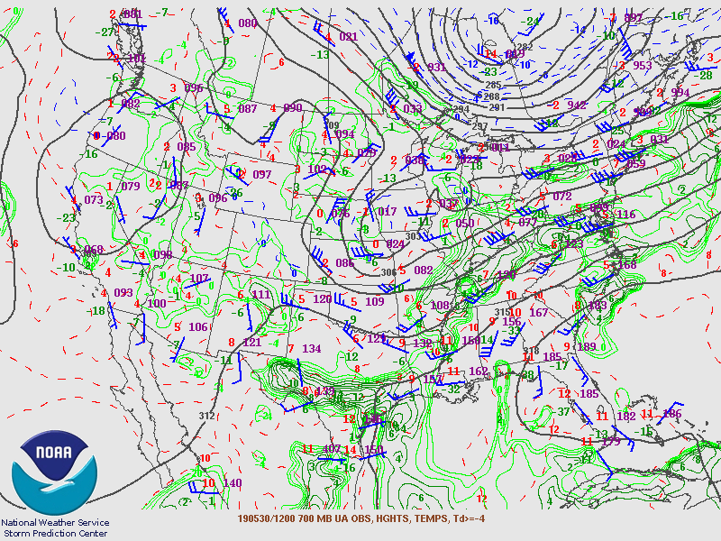
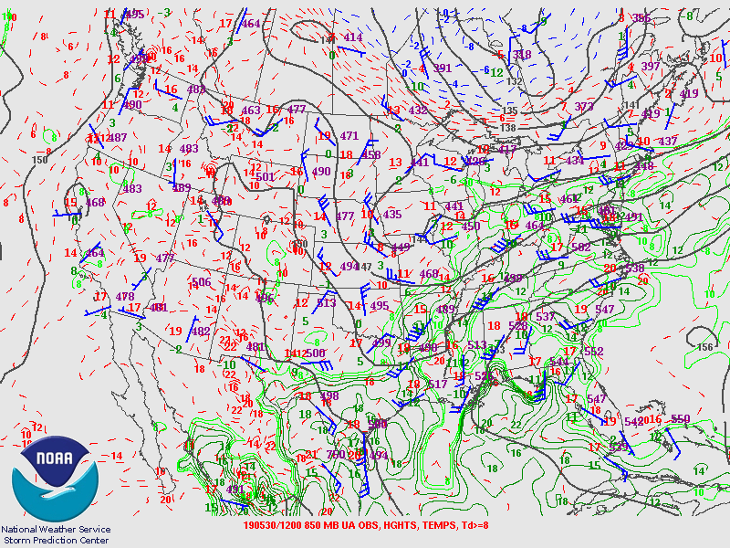
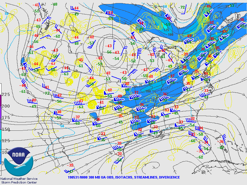
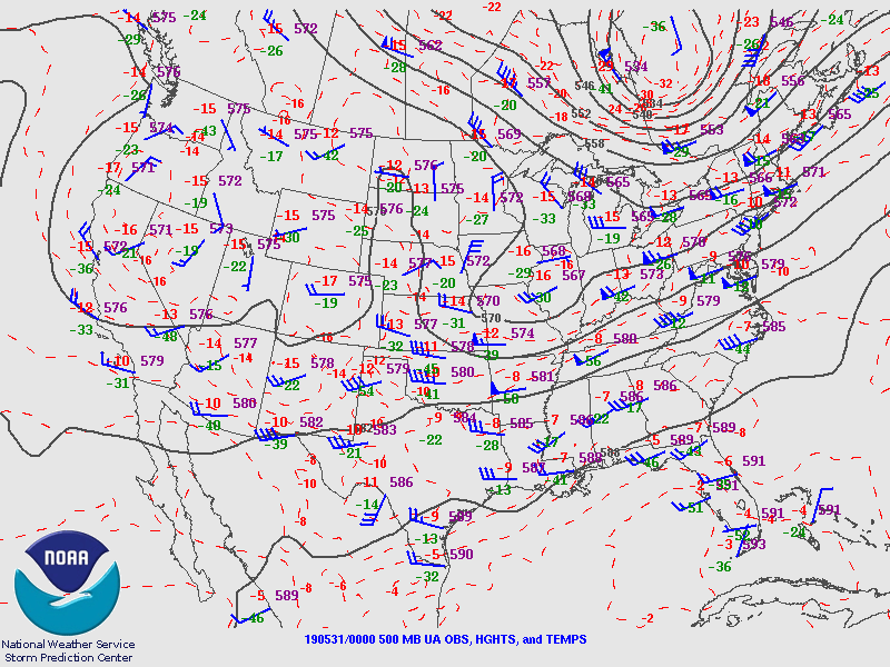
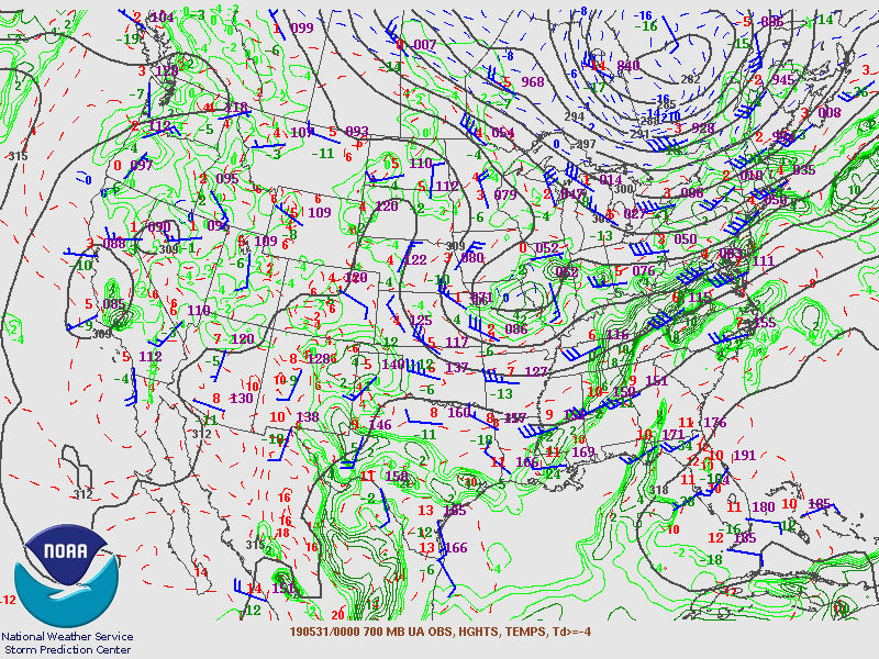
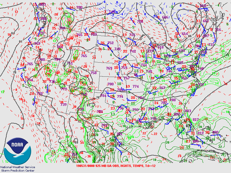
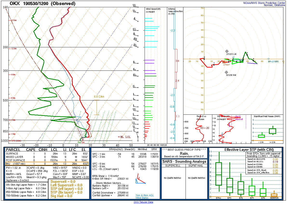
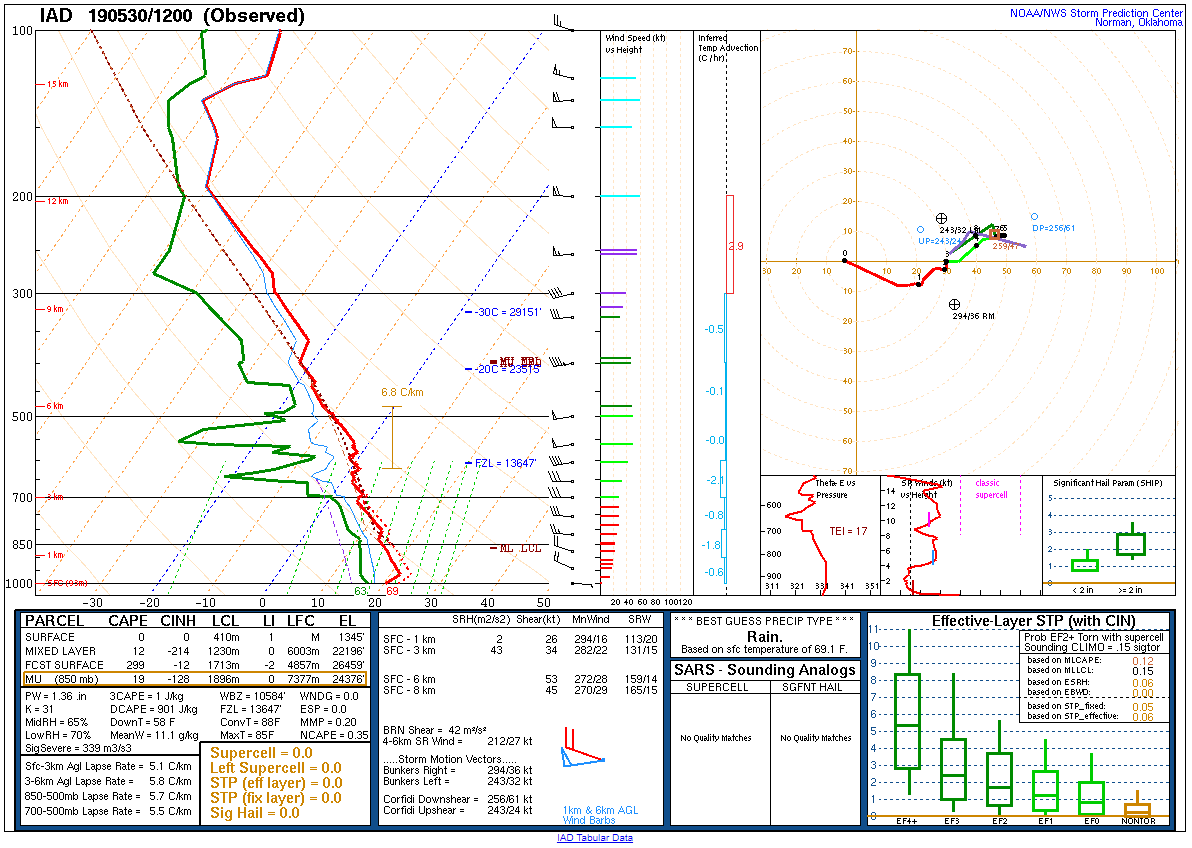
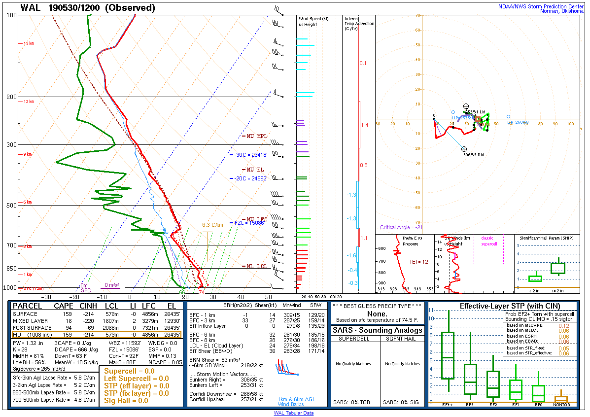
Synoptic Overview at 12z 30 May 2019 (courtesy of SPC)
 |
 |
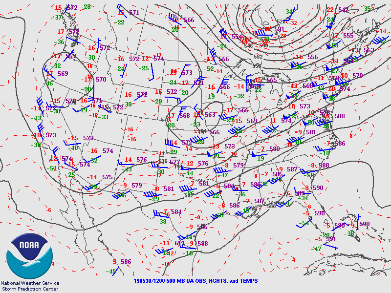 |
| Figure 1: 250-mb analysis | Figure 2: 300-mb analysis | Figure 3: 500-mb analysis |
 |
 |
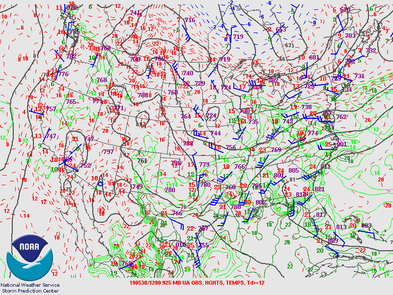 |
| Figure 4: 700-mb analysis | Figure 5: 850-mb analysis | Figure 6: 925-mb analysis |
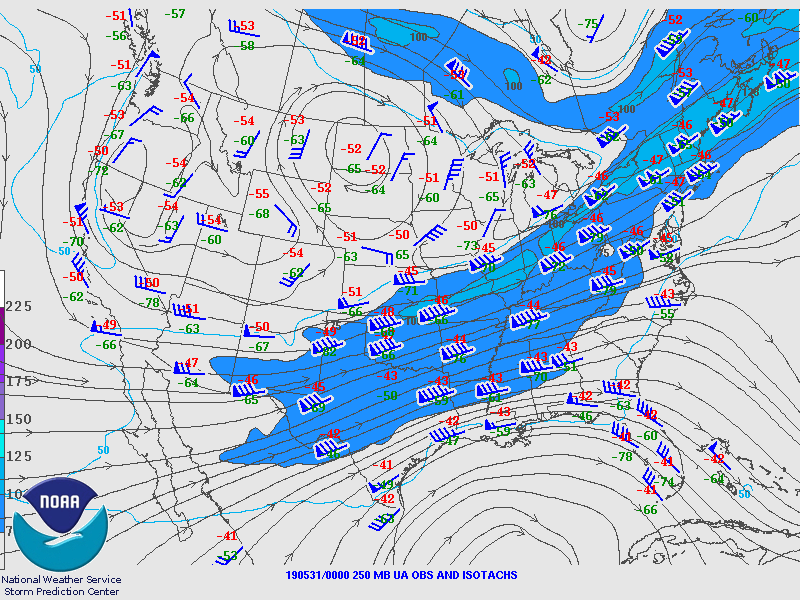
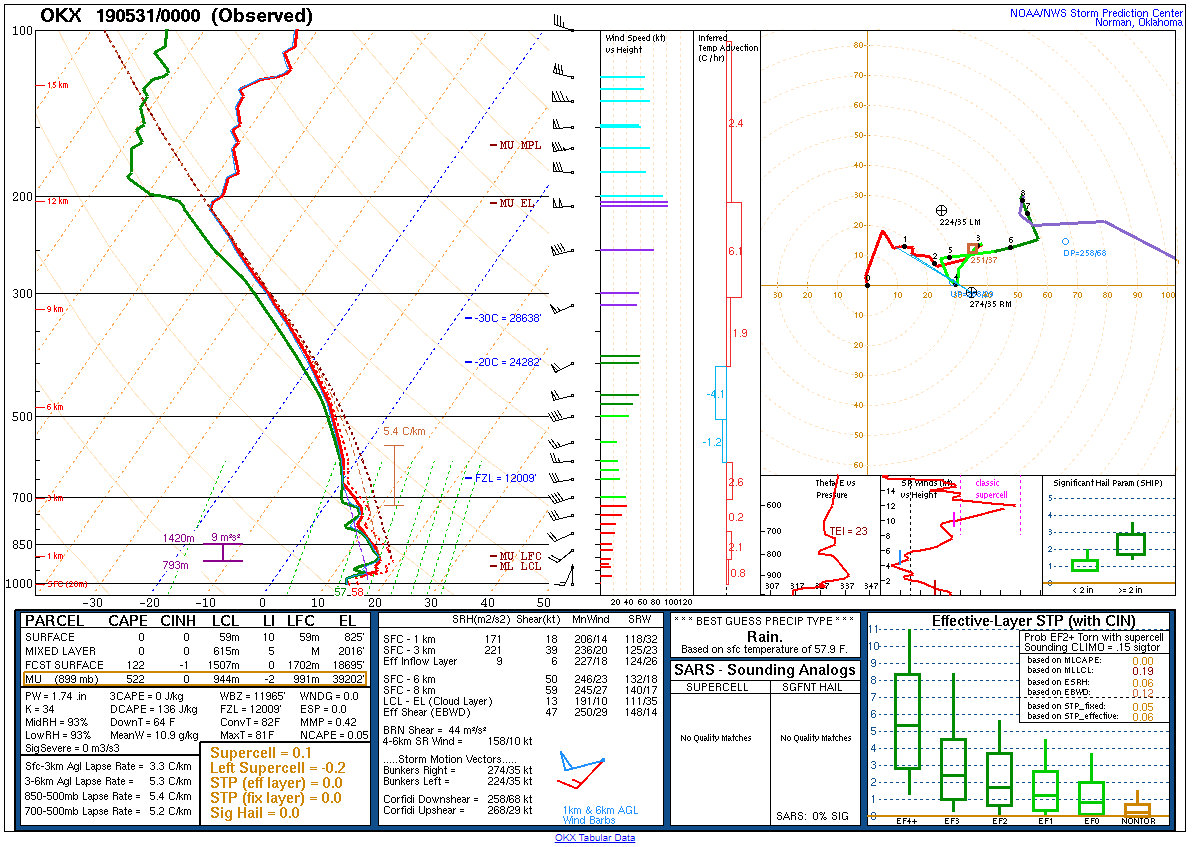
Synoptic Overview at 00z 31 May 2019 (courtesy of SPC)
 |
 |
 |
| Figure 7: 250-mb analysis | Figure 8: 300-mb analysis | Figure 9: 500-mb analysis |
 |
 |
 |
| Figure 10: 700-mb analysis | Figure 11: 850-mb analysis | Figure 12: 925-mb analysis |
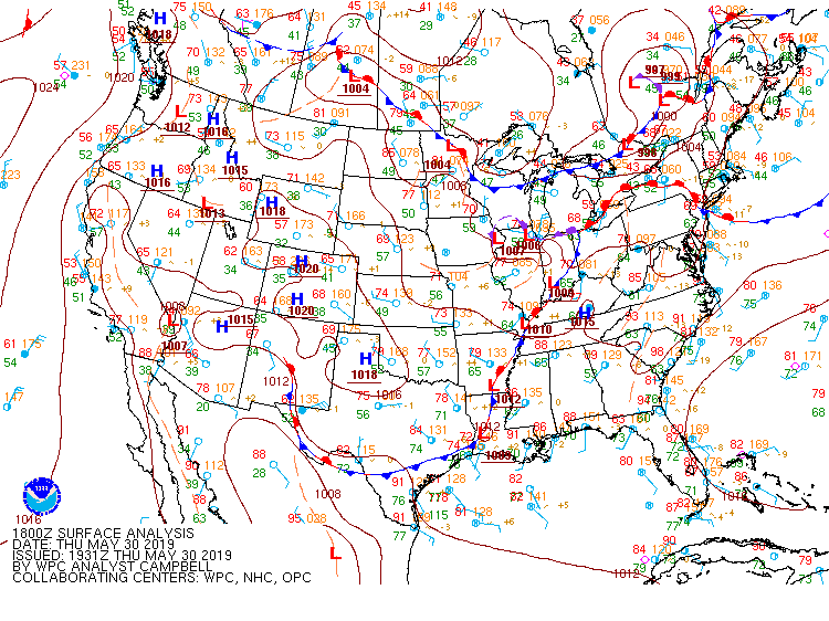
Surface Maps (courtesy of WPC)
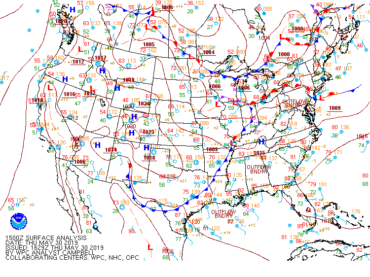 |
 |
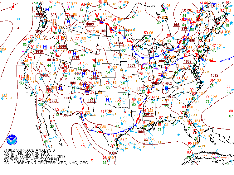 |
| Figure 13: 15z surface map | Figure 14: 18z surface map | Figure 15: 21z surface map |
 |
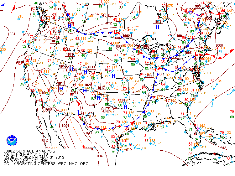 |
 |
| Figure 16: 00z surface map | Figure 17: 03z surface map | Figure 18: 06z surface map |
 |
 |
 |
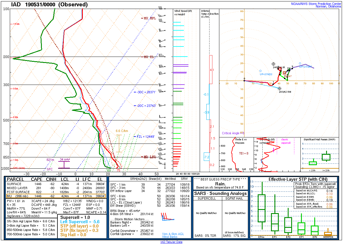
| Figure 19: 12z Upton, NY sounding | Figure 20: 12z Sterling, VA sounding | Figure 21: 12z Wallops Island, VA sounding |
 |
 |
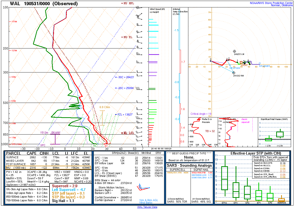 |
| Figure 22: 00z Upton, NY sounding | Figure 23: 00z Sterling, VA sounding | Figure 24: 00z Wallops Island, VA sounding |
 |
 |
 |
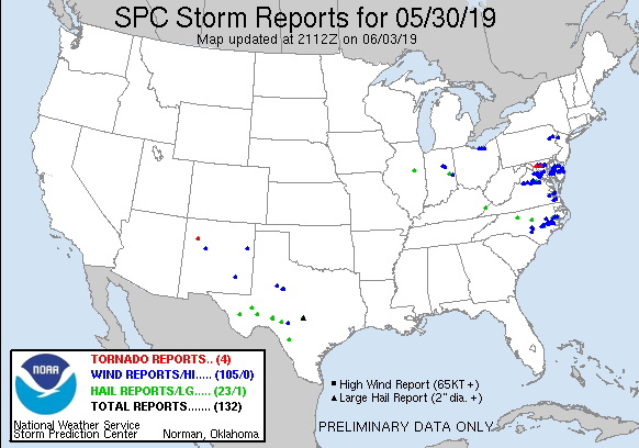
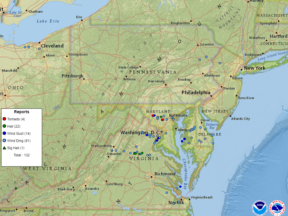
| Figure 1: National Preliminary Reports 12z 30 May 2019 to 12z 31 May 2019 | Figure 2: Zoomed Preliminary Reports for the same period. | Figure 3: Prelim Reports vs. 1630z SPC Convective Outlook |
Click here for a county warning area based plot of local storm reports and warnings/advisories issued for the 30 May 2019 event.
Flash Flood Watch 0005
Severe Thunderstorm Watch 0297
Severe Thunderstorm Warning 0103
Areal Flood Advisory 0064
Areal Flood Advisory 0065
Areal Flood Advisory 0066
Severe Thunderstorm Warning 0104
Severe Thunderstorm Warning 0105
Severe Thunderstorm Warning 0106
Severe Thunderstorm Warning 0107
Flash Flood Warning 0011
Areal Flood Advisory 0067
Special Marine Warning 0053
Areal Flood Advisory 0068
Severe Thunderstorm Warning 0108
Flash Flood Warning 0012
Severe Thunderstorm Warning 0109
Areal Flood Advisory 0069
Severe Thunderstorm Warning 0110
Special Marine Warning 0054
Severe Thunderstorm Warning 0111
Special Marine Warning 0055
Flash Flood Warning 0013
Flash Flood Warning 0014
Areal Flood Warning 0016
Areal Flood Warning 0017
Special Marine Warning 0056
Areal Flood Warning 0018
NWUS51 KPHI 021609
LSRPHI

PRELIMINARY LOCAL STORM REPORT...SUMMARY
NATIONAL WEATHER SERVICE MOUNT HOLLY NJ
1209 PM EDT SUN JUN 2 2019

..TIME...   ...EVENT...      ...CITY LOCATION...     ...LAT.LON...
..DATE...   ....MAG....      ..COUNTY LOCATION..ST.. ...SOURCE....
            ..REMARKS..

0430 PM     TSTM WND GST     CARVILLE                39.05N 76.01W
05/30/2019  M52 MPH          QUEEN ANNES       MD   MESONET


0430 PM     TSTM WND DMG     QUEEN ANNE              38.92N 75.96W
05/30/2019                   QUEEN ANNES       MD   911 CALL CENTER

            REPORTS OF TREES DOWN AND POWER OUTAGES NEAR
            THE QUEEN ANNE AREA ALONG THE QUEEN ANNES
            AND TALBOT COUNTY BORDER. TIME ESTIMATED
            FROM RADAR.

0435 PM     TSTM WND DMG     1 ESE OAKLAND           38.98N 75.87W
05/30/2019                   CAROLINE           MD   PUBLIC

            STRAIGHT-LINE WINDS ESTIMATED BETWEEN 60 AND
            70 MPH UPROOTED OR SNAPPED LARGE LIMBS FROM
            15 TREES. DELAYED REPORT FROM THURSDAY
            AFTERNOON.

0435 PM     TSTM WND DMG     RIDGELY                 38.95N 75.89W
05/30/2019                   CAROLINE           MD   911 CALL CENTER

            TREES AND WIRED DOWN IN RIDGELY. TIME BASED
            ON RADAR.

0440 PM     TSTM WND DMG     GREENSBORO              38.98N 75.81W
05/30/2019                   CAROLINE           MD   911 CALL CENTER

            TREES AND WIRES DOWN IN GREENSBORO. TIME
            ESTIMATED BY RADAR.

0445 PM     TSTM WND DMG     GOLDSBORO               39.04N 75.79W
05/30/2019                   CAROLINE           MD   911 CALL CENTER

            TREES AND WIRED DOWN IN GOLDSBORO. TIME
            ESTIMATED BY RADAR.

0450 PM     TSTM WND GST     2 N EASTON              38.80N 76.07W
05/30/2019  M47 MPH          TALBOT             MD   ASOS

            EASTON, MD ASOS GUST.

0454 PM     TSTM WND GST     OXFORD                  38.69N 76.17W
05/30/2019  M58 MPH          TALBOT             MD   MESONET


0455 PM     TSTM WND DMG     ALBRIGHTSVILLE          41.01N 75.60W
05/30/2019                   CARBON             PA   PUBLIC

            DOWNED TREES AND POWERLINES IN
            ALBRIGHTSVILLE.

0502 PM     TSTM WND DMG     1 NE FELTON             39.02N 75.56W
05/30/2019                   KENT               DE   911 CALL CENTER

            TREE DOWN INTO WIRES IN FELTON. TIME
            ESTIMATED FROM RADAR.

0504 PM     FLOOD            1 ENE BRASS CASTLE      40.76N 75.00W
05/30/2019                   WARREN             NJ   DEPT OF HIGHWAYS

            KINNAMAN AVE FLOODED.

0505 PM     TSTM WND DMG     PRESTON                 38.72N 75.91W
05/30/2019                   CAROLINE           MD   911 CALL CENTER

            WIRES DOWN IN PRESTON. TIME ESTIMATED BY
            RADAR.

0510 PM     TSTM WND DMG     ALLAMUCHY-PANTHER VALLE 40.91N 74.83W
05/30/2019                   WARREN             NJ   COUNTY OFFICIAL

            SOME REPORTS OF A FEW TREES DOWN IN
            ALLAMUCHY TWP. TIME ESTIMATED FROM RADAR.

0514 PM     TSTM WND DMG     4 WSW BIG STONE BEACH   38.97N 75.39W
05/30/2019                   KENT               DE   911 CALL CENTER

            MULTIPLE REPORTS OF TREES ACROSS ROADWAYS
            AND TREES INTO WIRES IN SOUTH BOWERS. TIME
            ESTIMATED FROM RADAR.

0520 PM     FLOOD            1 W ROXBURG             40.78N 75.13W
05/30/2019                   WARREN             NJ   DEPT OF HIGHWAYS

            FLOODING ON HUTCHINSON RIVER RD.

0520 PM     TSTM WND DMG     1 SW SEAFORD            38.64N 75.62W
05/30/2019                   SUSSEX             DE   FIRE DEPT/RESCUE

            DOWNED WIRES AT INTERSECTION OF BRADFORD
            STREET AND PENNSYLVANIA AVENUE. TIME
            ESTIMATED FROM RADAR.

0526 PM     TSTM WND DMG     GEORGETOWN              38.69N 75.39W
05/30/2019                   SUSSEX             DE   911 CALL CENTER

            DOWNED TREES IN GEORGETOWN. TIME ESTIMATED
            FROM RADAR.

0530 PM     FLASH FLOOD      FORKS TWP               40.73N 75.19W
05/30/2019                   NORTHAMPTON        PA   NEWSPAPER

            DELAYED REPORT. NUMEROUS ROADS FLOODED AND
            IMPASSABLE IN FORKS TWP, INCLUDING
            KESSLERSVILLE ROAD AT HUNTER ROAD, RICHMOND
            ROAD AT SHORT ROAD, GLOVER ROAD AND PADULA
            ROAD, WEST NEWLINS ROAD AT SULLIVAN TRAIL,
            AND KLEIN ROAD. PHOTOS INDICATE INUNDATION
            OF 2 TO MORE THAN 4 FEET ON SOME ROADS. TIME
            ESTIMATED FROM NEARBY REPORTS AND RADAR.

0531 PM     TSTM WND DMG     2 NNE LAKESIDE MANOR    38.59N 75.54W
05/30/2019                   SUSSEX             DE   DEPT OF HIGHWAYS

            U.S. HIGHWAY 9 CLOSED BETWEEN FIRE TOWER
            ROAD AND KAYE ROAD OWING TO DOWNED TREES AND
            POWER LINES. TIME ESTIMATED FROM RADAR.

0538 PM     TSTM WND DMG     LEWES                   38.78N 75.13W
05/30/2019                   SUSSEX             DE   911 CALL CENTER

            SEVERAL DOWNED TREES IN LEWES. TIME
            ESTIMATED FROM RADAR.

0540 PM     FLOOD            1 SE ROXBOROUGH         39.99N 75.21W
05/30/2019                   PHILADELPHIA       PA   TRAINED SPOTTER

            UP TO FOUR FEET OF WATER UNDER AN OVERPASS
            ON FAIRMOUNT PARK DR.

0540 PM     TSTM WND GST     2 WNW LEWES             38.79N 75.16W
05/30/2019  M53 MPH          SUSSEX             DE   MESONET

            MEASURED BY WXFLOW GAUGE.

0542 PM     MARINE TSTM WIND CAPE HENLOPEN BEACH     38.81N 75.10W
05/30/2019  M46 MPH          ANZ431             DE   MESONET

            DELAYED REPORT FROM THURSDAY.

0542 PM     MARINE TSTM WIND 1 ENE LEWES             38.78N 75.11W
05/30/2019  M46 MPH          SUSSEX             DE   MESONET


0545 PM     MARINE TSTM WIND 1 WNW LEWES             38.79N 75.15W
05/30/2019  M43 MPH          SUSSEX             DE   MESONET


0546 PM     FLOOD            1 S PORT MURRAY         40.77N 74.92W
05/30/2019                   WARREN             NJ   COUNTY OFFICIAL

            CHANGEWATER ROAD FLOODED FROM ASBURY
            ANDERSON ROAD TO THE HUNTERDON COUNTY LINE.

0548 PM     MARINE TSTM WIND DEWEY BEACH             38.69N 75.07W
05/30/2019  M51 MPH          ANZ455             DE   MESONET

            DELAYED REPORT FROM THURSDAY.

0548 PM     TSTM WND GST     INDIAN BEACH            38.68N 75.08W
05/30/2019  M52 MPH          SUSSEX             DE   MESONET

            MEASURED BY WXFLOW GAUGE.

0548 PM     FLOOD            1 ESE TACONY            40.02N 75.03W
05/30/2019                   PHILADELPHIA       PA   DEPT OF HIGHWAYS

            FLOODING ON INTERSTATE 95 AT EXIT 30. RAMP
            CLOSURE IN PLACE.

0548 PM     MARINE TSTM WIND INDIAN BEACH            38.68N 75.08W
05/30/2019  M52 MPH          SUSSEX             DE   MESONET

            MEASURED BY WXFLOW GAUGE.

0548 PM     MARINE TSTM WIND 1 SSW NORTH CAPE MAY    38.97N 74.96W
05/30/2019  M42 MPH          CAPE MAY           NJ   MESONET

            CMAN4 NOS GAUGE.

0550 PM     MARINE TSTM WIND 2 WNW LEWES             38.79N 75.16W
05/30/2019  M53 MPH          SUSSEX             DE   MESONET

            MEASURED BY WXFLOW GAUGE.

0552 PM     TSTM WND DMG     1 ENE MILLVILLE         38.55N 75.09W
05/30/2019                   SUSSEX             DE   911 CALL CENTER

            SEVERAL DOWNED TREES IN THE MILLVILLE AND
            OCEAN VIEW AREA. TIME ESTIMATED FROM RADAR.

0558 PM     FLOOD            1 NE MANSFIELD TWP      40.81N 74.90W
05/30/2019                   WARREN             NJ   COUNTY OFFICIAL

            FLOODING REPORTED ON ROCKPORT ROAD IN
            MANSFIELD TWP.

0603 PM     MARINE TSTM WIND INDIAN BEACH            38.68N 75.08W
05/30/2019  M47 MPH          SUSSEX             DE   MESONET

            MEASURED BY WXFLOW GAUGE.

0611 PM     FLOOD            1 NNE LAWRENCE PARK     39.98N 75.34W
05/30/2019                   DELAWARE           PA   DEPT OF HIGHWAYS

            FLOODING ON INTERSTATE 476 NEAR THE BROOMALL
            EXIT. LANE RESTRICTIONS IN PLACE.

0629 PM     FLOOD            1 NW LOWER FREDERICK TW 40.29N 75.48W
05/30/2019                   MONTGOMERY         PA   PUBLIC

            SALFORD STATION ROAD CLOSED NEAR STATE
            HIGHWAY 29 DUE TO FLOODING.

0636 PM     FLOOD            1 SE ROXBOROUGH         39.99N 75.21W
05/30/2019                   PHILADELPHIA       PA   PUBLIC

            MARTIN LUTHER KING JR. DRIVE CLOSED NEAR
            MONTGOMERY DRIVE FROM FLOODING.

0656 PM     FLASH FLOOD      2 ENE SOMERVILLE        40.58N 74.58W
05/30/2019                   SOMERSET           NJ   DEPT OF HIGHWAYS

            U.S. HIGHWAY 22 CLOSED AT NORTH ADAMSVILLE
            ROAD FROM FLASH FLOODING.

0657 PM     FLASH FLOOD      1 N BOUND BROOK         40.58N 74.53W
05/30/2019                   SOMERSET           NJ   DEPT OF HIGHWAYS

            U.S. HIGHWAY 22 CLOSED AT MOUNTAIN AVENUE
            FROM FLASH FLOODING.

0700 PM     FLOOD            2 NNE BASKING RIDGE     40.73N 74.54W
05/30/2019                   MORRIS             NJ   DEPT OF HIGHWAYS

            FLOODING ON INTERSTATE 287 NORTHBOUND NEAR
            EXIT 30. LANE RESTRICTIONS IN PLACE.

0702 PM     FLOOD            2 SSW MARTINSVILLE      40.58N 74.57W
05/30/2019                   SOMERSET           NJ   DEPT OF HIGHWAYS

            FLOODING ON INTERSTATE 287 NORTHBOUND AT
            EXIT 14. RAMP CLOSURE IN PLACE.

0712 PM     FLOOD            2 NW WHITE HOUSE STATIO 40.64N 74.79W
05/30/2019                   HUNTERDON          NJ   DEPT OF HIGHWAYS

            FLOODING ON U.S. HIGHWAY 22 NEAR POTTERSTOWN
            ROAD IN READINGTON TWP. LANE RESTRICTIONS IN
            PLACE.

0736 PM     FLOOD            1 E MADISON             40.76N 74.39W
05/30/2019                   MORRIS             NJ   DEPT OF HIGHWAYS

            STATE HIGHWAY 24 NEAR EXIT 7 FLOODED WITH
            LANE RESTRICTIONS IN PLACE.

0738 PM     FLOOD            3 WSW PLEASANT VALLEY   40.73N 75.06W
05/30/2019                   WARREN             NJ   DEPT OF HIGHWAYS

            STATE HIGHWAY 57 FLOODED NEAR ASBURY
            BROADWAY ROAD IN FRANKLIN TWP. LANE
            RESTRICTIONS IN PLACE.


&&

$$

CMS
Delmarva MCS (GR2Analyst)
 |
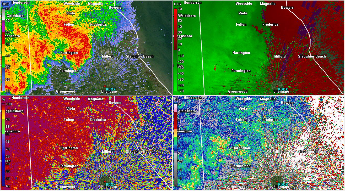 |
| Figure 1: Loop of KDOX radar reflectivity factor (top left), base velocity (top right), correlation coefficient (CC; bottom left), and differential reflectivity (ZDR; bottom right) valid from 2028 UTC to 2047 UTC on 30 May 2019. During this portion of the event in Delmarva, several instances of wind damage occurred in northern Caroline County (MD) between Ridgely and Goldsboro. The loop suggests velocities around 1500 feet above ground level (AGL) were well in excess of 50 kts. The storm was also exhibiting characteristics of bowing (bending downstream, as in the extension of a bow). This is strongly indicative of an intense rear-inflow jet (horizontal stream of air coming into the storms from behind) that is forced downward to the surface as the flow of air reaches the downdraft. The loop indicates these strong winds were fairly widespread across the area where wind damage occurred. Note the base velocities markedly change appearance in the last two frames; this is because of a change in the configuration of the radar that allowed for less velocity folding (increased the scale of the velocities). Base velocities were actually similar in magnitude throughout this loop. | Figure 2: Same as Fig. 1, valid from 2105 to 2117 UTC on 30 May 2019. Several reports of wind damage occurred between Ellendale and Frederica, and radar is strongly suggestive of a bowing segment within the broader line of storms (near and north of Milford, in particular). Note that velocities are not particularly impressive, but this is because the winds are mostly perpendicular to the radar beam at this time (which are not picked up by the radar). In the last frame of the loop, stronger velocities begin to appear near Slaughter Beach, since the beam becomes more parallel to the motion of the winds again (and imply magnitudes 70+ kts around 1500 ft AGL). |


 Coastal Flood
 Marine Forecasts
 Text Products
 Climate Information
 Skywarn
 Submit Storm Report
 Weather Event Archives
 Forecast Discussion
 Emergency Managers
 Briefing Page