
A heat wave over the Southwest will intensify this week, peaking and expanding into the Intermountain West and northern High Plains this weekend. Critical to extremely critical fire weather conditions are forecast from the Northwest and the northern Great Basin this weekend. Particularly Dangerous Situation Red Flag Warnings have been issued. Read More >
Overview
|
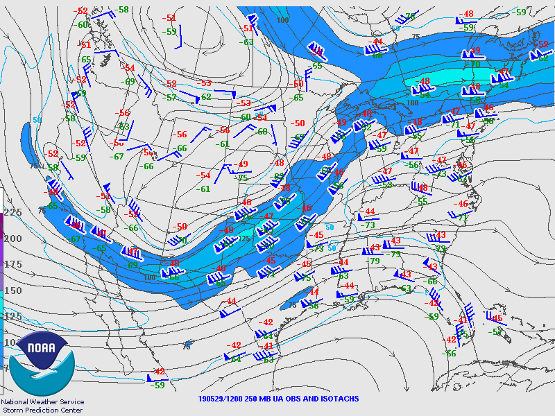
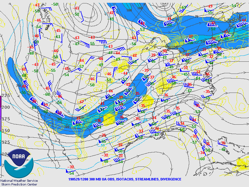
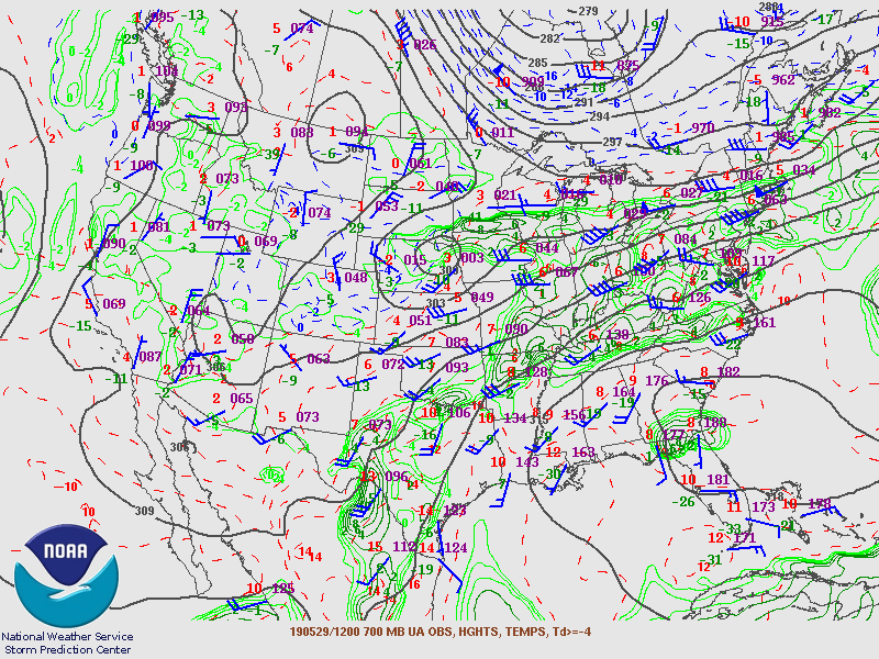
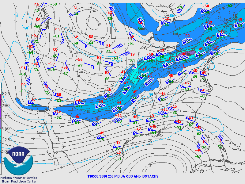
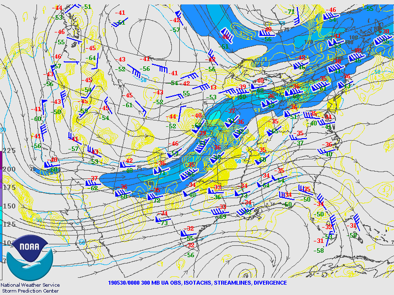
A midlevel vorticity maximum approached the Northeast and Mid-Atlantic on 29 May 2019, with a weak surface low progressing eastward along a quasi-zonally oriented baroclinic zone stretching from the Ohio Valley to the East Coast. Strong heating to the south of the associated warm front allowed for the development of numerous severe storms by early afternoon. The environment was quite favorable for significant severe weather, with mixed-layer CAPE (MLCAPE) exceeding 2000 J/kg and deep-layer bulk shear in excess of 45 kts. Storms remained relatively discrete through late afternoon, allowing for the development of intense and long-lived supercells that produced large (up to 2 inches in diameter) hail in eastern Pennsylvania and adjacent northern/central New Jersey as well as a brief tornado in Lehigh and Bucks Counties. Storms eventually congealed into a quasi-linear convective system, with the main hazards transitioning to wind damage and flash flooding. Training of storms occurred in portions of eastern Pennsylvania and central New Jersey, where several instances of flash flooding occurred. Sadly, there was one fatality in Bucks County associated with flash flooding on Neshaminy Creek. |
 Composite radar loop of the Lehigh Valley supercell on 29 May 2019. |
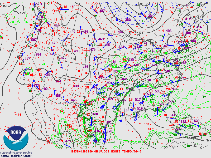
Synoptic Overview at 12z 29 May 2019 (courtesy of SPC)
 |
 |
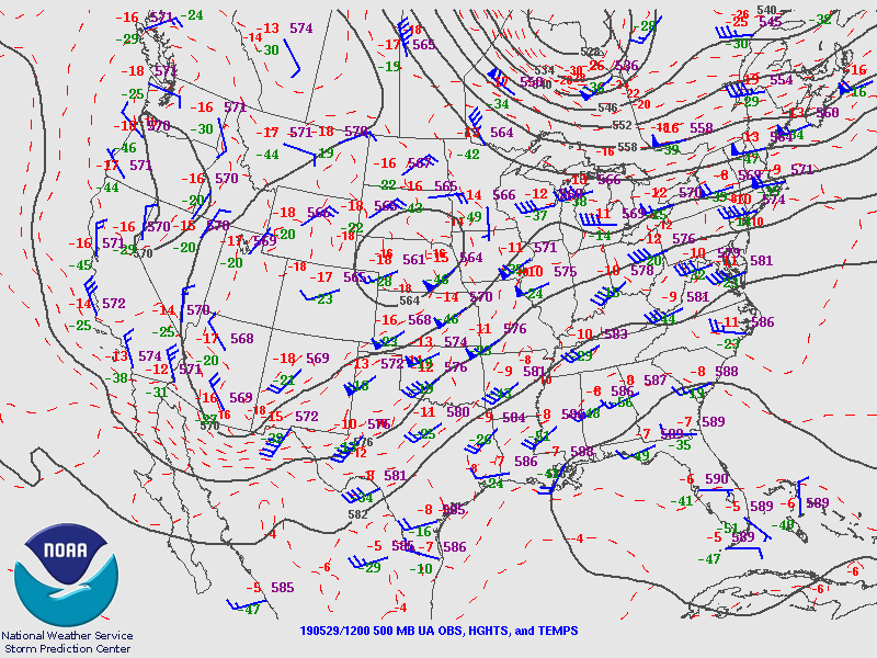 |
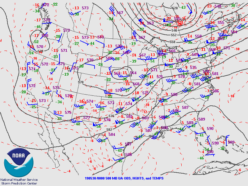
| Figure 1: 250-mb analysis | Figure 2: 300-mb analysis | Figure 3: 500-mb analysis |
 |
 |
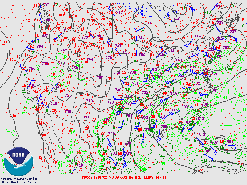 |
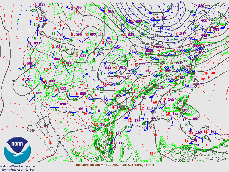
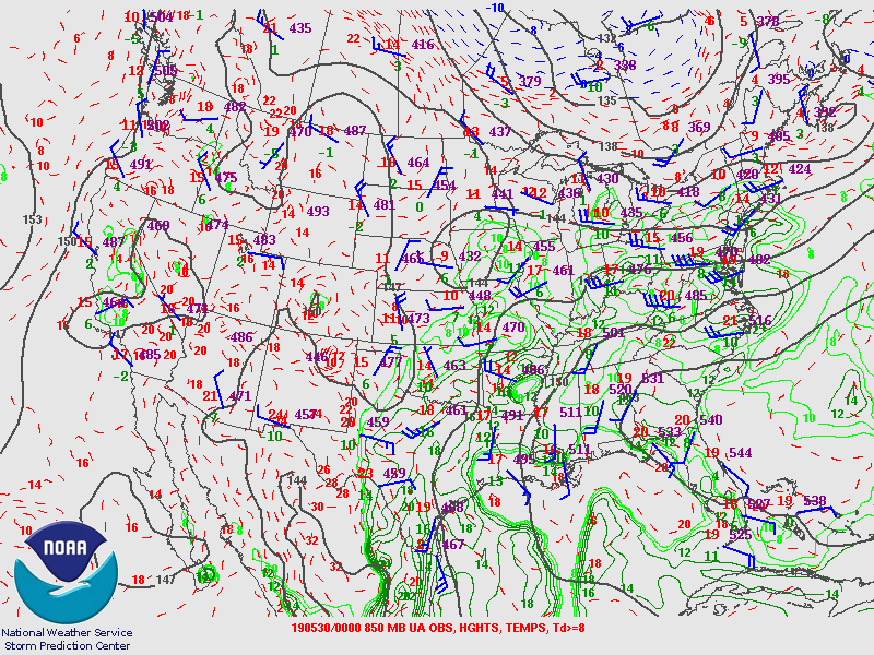
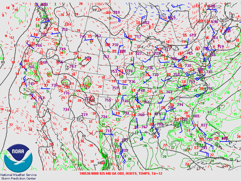
| Figure 4: 700-mb analysis | Figure 5: 850-mb analysis | Figure 6: 925-mb analysis |
Synoptic Overview at 00z 30 May 2019 (courtesy of SPC)
 |
 |
 |
| Figure 7: 250-mb analysis | Figure 8: 300-mb analysis | Figure 9: 500-mb analysis |
 |
 |
 |
| Figure 10: 700-mb analysis | Figure 11: 850-mb analysis | Figure 12: 925-mb analysis |
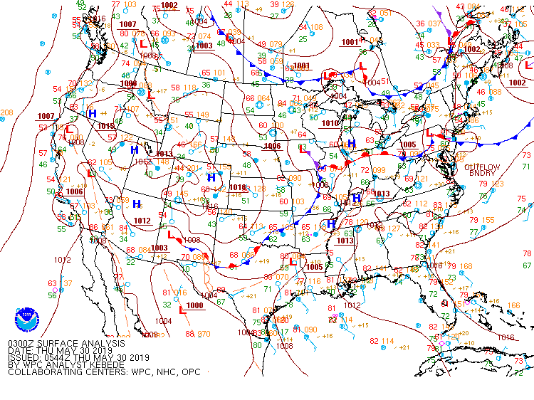
Surface Maps (courtesy of WPC)
 |
 |
 |
| Figure 13: 15z surface map | Figure 14: 18z surface map | Figure 15: 21z surface map |
 |
 |
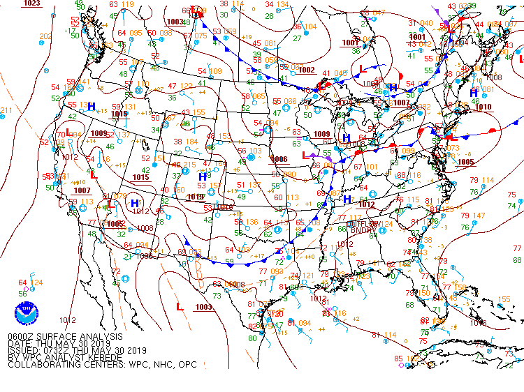 |
| Figure 16: 00z surface map | Figure 17: 03z surface map | Figure 18: 06z surface map |
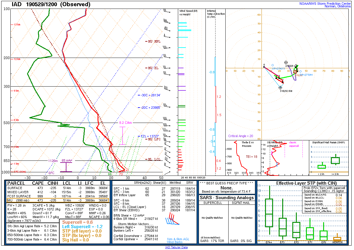
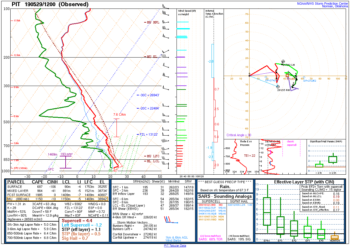 |
 |
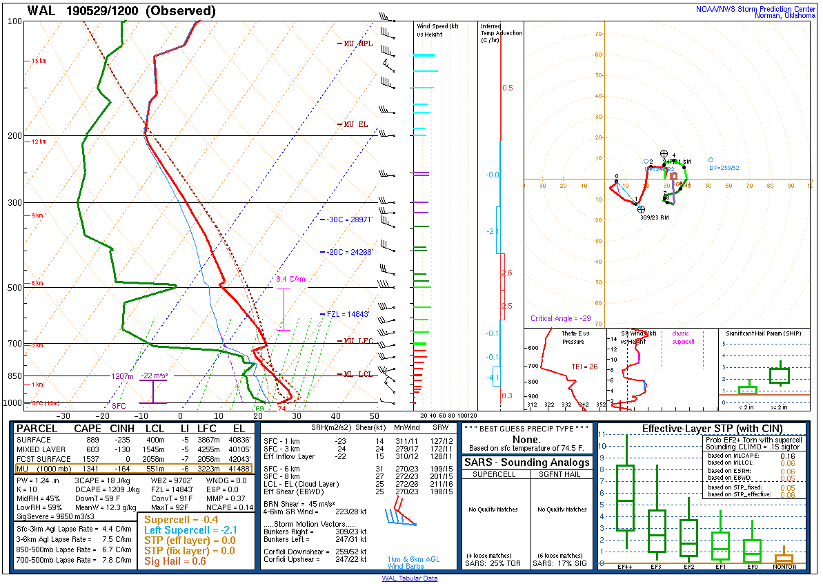 |
| Figure 19: 12z Pittsburgh, PA sounding | Figure 20: 12z Sterling, VA sounding | Figure 21: 12z Wallops Island, VA sounding |
 |
 |
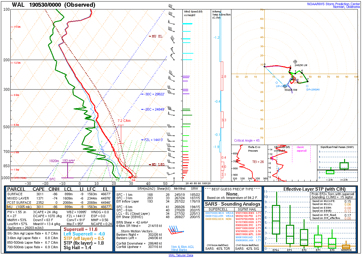 |
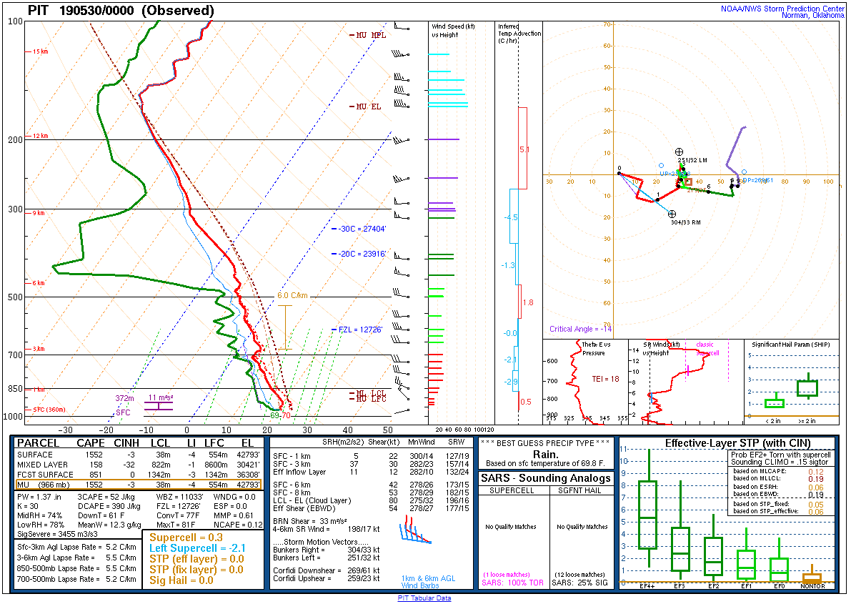
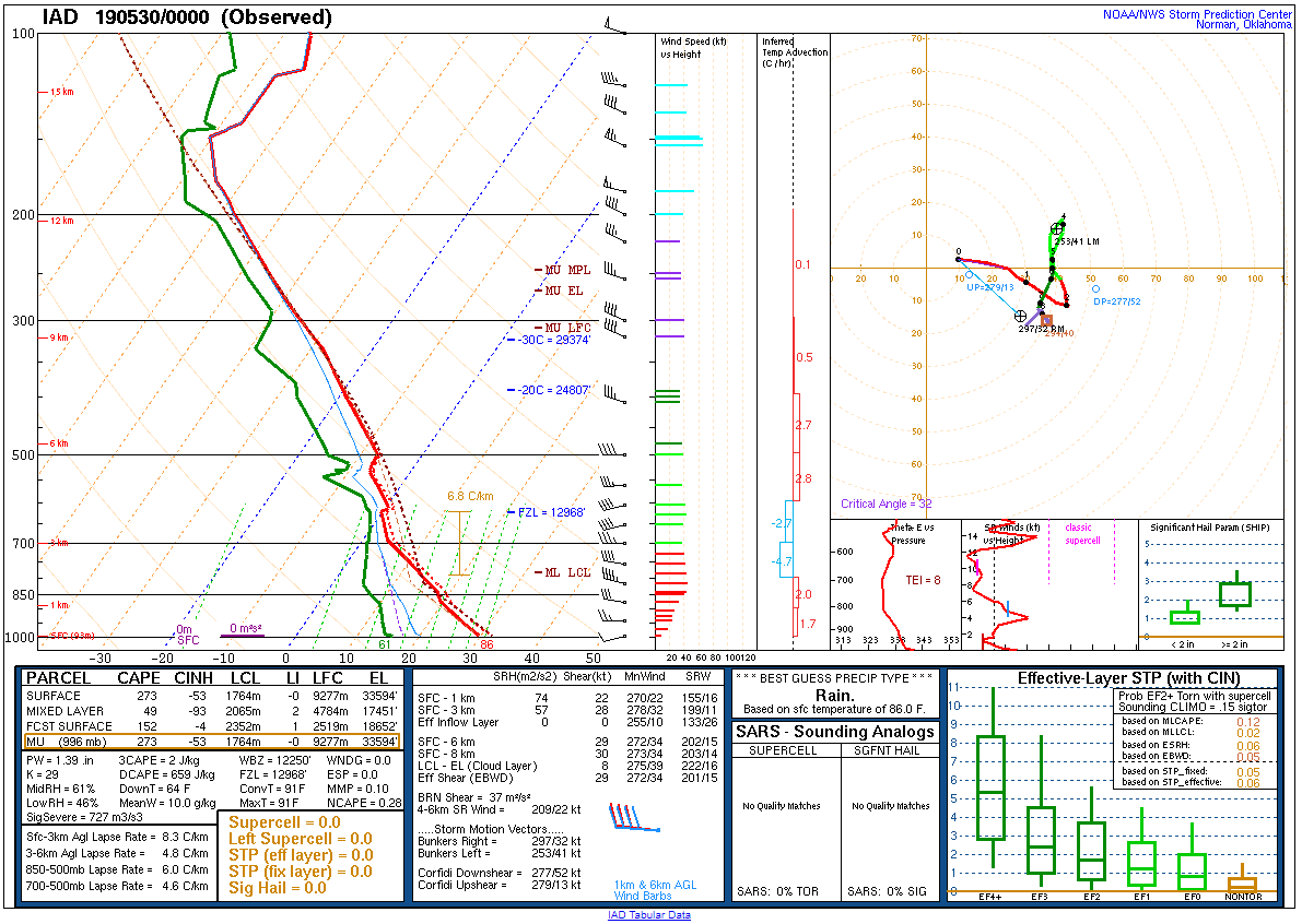
| Figure 22: 00z Pittsburgh, PA sounding | Figure 23: 00z Sterling, VA sounding | Figure 24: 00z Wallops Island, VA sounding |
 |
 |
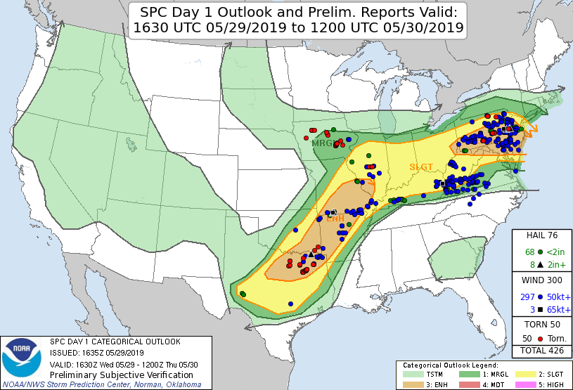 |
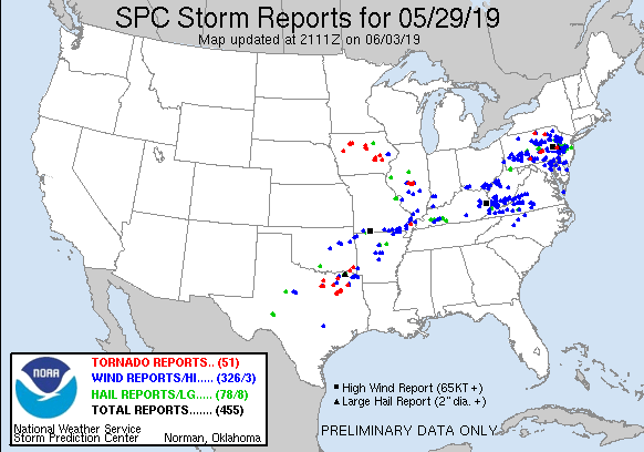
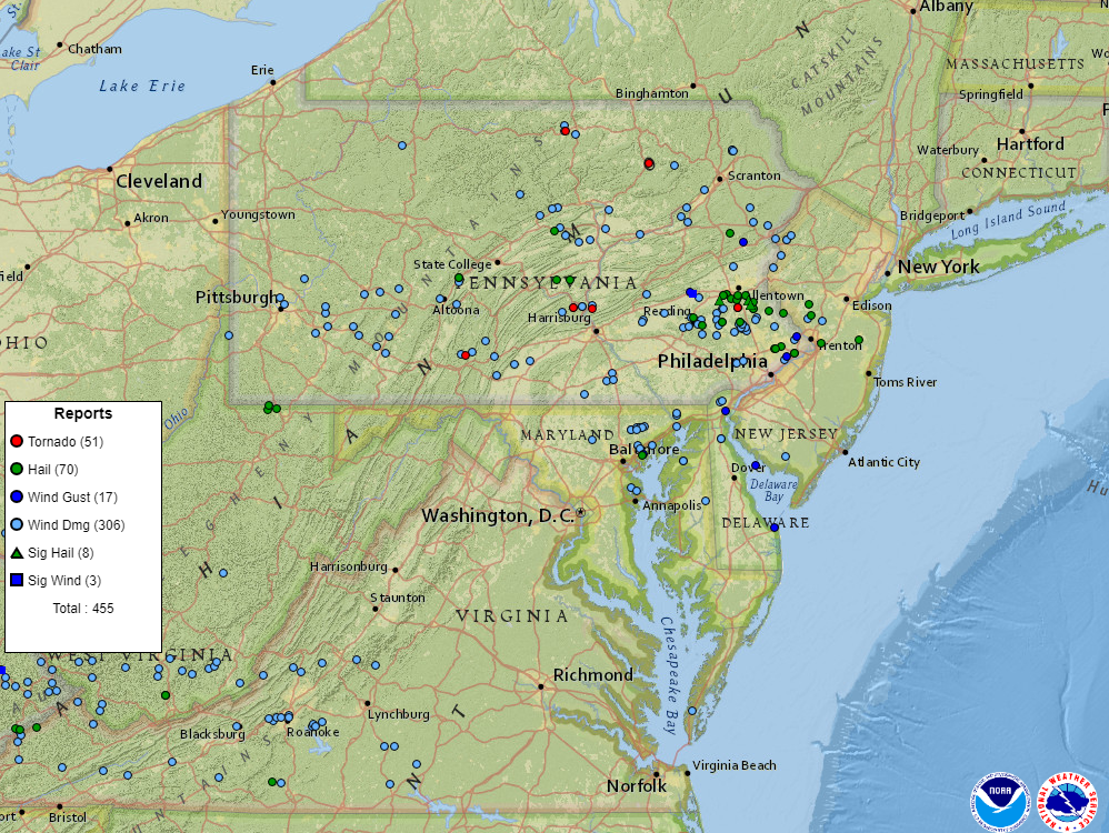
| Figure 1: National Preliminary Reports 12z 29 May 2019 to 12z 30 May 2019 | Figure 2: Zoomed Preliminary Reports for the same period. | Figure 3: Prelim Reports vs. 1630z SPC Convective Outlook |
Click here for a county warning area based plot of local storm reports and warnings/advisories issued for the 29 May 2019 event.
Flash Flood Watch 0004
Tornado Watch 0292
Severe Thunderstorm Warning 0078
Severe Thunderstorm Warning 0079
Severe Thunderstorm Warning 0080
Tornado Warning 0017
Severe Thunderstorm Warning 0081
Severe Thunderstorm Warning 0082
Tornado Warning 0018
Severe Thunderstorm Warning 0083
Severe Thunderstorm Warning 0084
Flash Flood Warning 0005
Severe Thunderstorm Warning 0085
Severe Thunderstorm Warning 0086
Severe Thunderstorm Warning 0087
Severe Thunderstorm Warning 0088
Severe Thunderstorm Warning 0089
Areal Flood Advisory 0061
Severe Thunderstorm Warning 0090
Severe Thunderstorm Warning 0091
Severe Thunderstorm Warning 0092
Severe Thunderstorm Warning 0093
Flash Flood Warning 0006
Special Marine Warning 0045
Tornado Warning 0019
Flash Flood Warning 0007
Severe Thunderstorm Warning 0094
Flash Flood Warning 0008
Tornado Warning 0020
Severe Thunderstorm Warning 0095
Severe Thunderstorm Warning 0096
Special Marine Warning 0046
Severe Thunderstorm Warning 0097
Flash Flood Warning 0009
Severe Thunderstorm Warning 0098
Severe Thunderstorm Warning 0099
Severe Thunderstorm Warning 0100
Flash Flood Warning 0010
Special Marine Warning 0047
Severe Thunderstorm Warning 0101
Areal Flood Advisory 0062
Special Marine Warning 0048
Special Marine Warning 0049
Severe Thunderstorm Warning 0102
Special Marine Warning 0050
Special Marine Warning 0051
Areal Flood Advisory 0063
River Flood Warning 0010
Special Marine Warning 0052
Areal Flood Warning 0015
NWUS51 KPHI 021609
LSRPHI
PRELIMINARY LOCAL STORM REPORT...SUMMARY
NATIONAL WEATHER SERVICE MOUNT HOLLY NJ
1209 PM EDT SUN JUN 2 2019
..TIME... ...EVENT... ...CITY LOCATION... ...LAT.LON...
..DATE... ....MAG.... ..COUNTY LOCATION..ST.. ...SOURCE....
..REMARKS..
0245 PM HAIL TREXLERTOWN 40.55N 75.60W
05/29/2019 M1.00 INCH LEHIGH PA PUBLIC
0250 PM HAIL MERTZTOWN 40.51N 75.67W
05/29/2019 M2.00 INCH BERKS PA TRAINED SPOTTER
HAIL UP TO 2 INCHES REPORTED IN MERTZTOWN.
0252 PM HAIL KUTZTOWN 40.52N 75.78W
05/29/2019 M0.75 INCH BERKS PA PUBLIC
0253 PM HAIL BREINIGSVILLE 40.54N 75.63W
05/29/2019 E1.75 INCH LEHIGH PA PUBLIC
TIME ESTIMATED FROM RADAR.
0300 PM HAIL BREINIGSVILLE 40.54N 75.63W
05/29/2019 M1.00 INCH LEHIGH PA TRAINED SPOTTER
0300 PM HAIL EMMAUS 40.53N 75.49W
05/29/2019 M1.25 INCH LEHIGH PA TRAINED SPOTTER
0305 PM HAIL TREXLERTOWN 40.55N 75.60W
05/29/2019 M0.25 INCH LEHIGH PA TRAINED SPOTTER
0306 PM HAIL TREXLERTOWN 40.55N 75.60W
05/29/2019 M0.75 INCH LEHIGH PA TRAINED SPOTTER
0308 PM HAIL MACUNGIE 40.52N 75.56W
05/29/2019 M1.75 INCH LEHIGH PA TRAINED SPOTTER
0314 PM HAIL VERA CRUZ 40.51N 75.50W
05/29/2019 E1.75 INCH LEHIGH PA PUBLIC
TIME ESTIMATED FROM RADAR.
0314 PM TORNADO 2 NNW GERYVILLE 40.45N 75.49W
05/29/2019 LEHIGH PA NWS STORM SURVEY
NWS STORM SURVEY CONFIRMED AN EF-0 TORNADO
DEVELOPED IN LOWER MILFORD TWP IN LEHIGH
COUNTY. TREES WERE SNAPPED AND UPROOTED
ALONG ITS 2.3 MILE PATH INTO NORTHERN
MILFORD TWP IN BUCKS COUNTY. MAXIMUM
ESTIMATED WINDS OF 80 MPH.
0315 PM HAIL EMMAUS 40.54N 75.49W
05/29/2019 E1.50 INCH LEHIGH PA TRAINED SPOTTER
0317 PM TSTM WND DMG 2 NW COOLBAUGH TWP 41.20N 75.37W
05/29/2019 MONROE PA PUBLIC
DELAYED REPORT. DOWNED TREES ON MOUNTAIN
DRIVE. TIME ESTIMATED FROM RADAR.
0319 PM HAIL UPPER SAUCON TWP 40.54N 75.41W
05/29/2019 E1.00 INCH LEHIGH PA PUBLIC
TIME ESTIMATED FROM RADAR.
0320 PM HAIL QUAKERTOWN 40.44N 75.34W
05/29/2019 M1.00 INCH BUCKS PA PUBLIC
0321 PM HAIL COOPERSBURG 40.51N 75.39W
05/29/2019 E2.00 INCH LEHIGH PA PUBLIC
PHOTOS OF HAIL LARGER THAN GOLF BALLS IN
COOPERSBURG. TIME ESTIMATED FROM RADAR.
0326 PM HAIL 5 SW PLEASANT VALLEY 40.47N 75.36W
05/29/2019 M2.00 INCH BUCKS PA TRAINED SPOTTER
HAIL FELL FOR APPROX 10 MINUTES. WIDESPREAD
QUARTER TO HALF DOLLAR SIZED HAIL WITH 2
INCH HAIL INCLUDED.
0335 PM TSTM WND DMG 2 NE ANALOMINK 41.07N 75.19W
05/29/2019 MONROE PA DEPT OF HIGHWAYS
DOWNED TREE IN WIRES ON SCHOOL HOUSE RD.
TIME ESTIMATED FROM RADAR.
0335 PM HAIL LANSFORD 40.83N 75.88W
05/29/2019 M0.50 INCH CARBON PA TRAINED SPOTTER
0343 PM TSTM WND DMG 1 W SWIFTWATER 41.09N 75.34W
05/29/2019 MONROE PA PUBLIC
CORRECTS PREVIOUS TSTM WND DMG REPORT FROM 1
W SWIFTWATER. DELAYED REPORT. DOWNED TREE ON
SUMMIT ROAD NEAR SWIFTWATER FORCING ITS
CLOSURE. TIME ESTIMATED FROM RADAR.
0343 PM HAIL BEDMINSTER 40.43N 75.18W
05/29/2019 E1.00 INCH BUCKS PA BROADCAST MEDIA
0345 PM HAIL ALBRIGHTSVILLE 41.01N 75.57W
05/29/2019 E1.25 INCH CARBON PA PUBLIC
TIME ESTIMATED FROM RADAR.
0355 PM HAIL QUAKERTOWN 40.44N 75.34W
05/29/2019 M1.50 INCH BUCKS PA PUBLIC
0356 PM TSTM WND DMG 1 NNW MARION TWP 40.41N 76.21W
05/29/2019 BERKS PA FIRE DEPT/RESCUE
DELAYED REPORT. DOWNED TREE AND WIRES ON
STONE ROAD NEAR ROUTE 419 IN TULPEHOCKEN
TWP. TIME ESTIMATED FROM RADAR.
0358 PM HAIL LUMBERVILLE 40.41N 75.04W
05/29/2019 E1.75 INCH BUCKS PA PUBLIC
0359 PM TSTM WND DMG 3 SSE LENHARTSVILLE 40.53N 75.87W
05/29/2019 BERKS PA FIRE DEPT/RESCUE
DELAYED REPORT OF TREE DOWN NEAR THE
INTERSECTION OF CRYSTAL CAVE ROAD AND
DUNKLES CHURCH ROAD IN RICHMOND TWP. TIME
ESTIMATED FROM RADAR.
0403 PM HAIL EFFORT 40.94N 75.44W
05/29/2019 E0.88 INCH MONROE PA TRAINED SPOTTER
0403 PM TSTM WND GST EFFORT 40.94N 75.44W
05/29/2019 E60 MPH MONROE PA TRAINED SPOTTER
0412 PM TSTM WND DMG PIKE TWP 40.41N 75.70W
05/29/2019 BERKS PA FIRE DEPT/RESCUE
DELAYED REPORT. SEVERAL REPORTS OF TREES AND
POWER LINES DOWN IN PIKE TWP, INCLUDING ON
HILL CHURCH ROAD, MERKLE ROAD, AND LUTZ
ROAD. TIME ESTIMATED FROM RADAR.
0415 PM TSTM WND DMG 2 SE DELAWARE WATER GAP 40.97N 75.12W
05/29/2019 MONROE PA FIRE DEPT/RESCUE
DELAYED REPORT. EXTENSIVE TREE DAMAGE ON
ROUTE 611 IN DELAWARE WATER GAP NATIONAL
RECREATION AREA. THE ROAD WAS CLOSED FOR
SEVERAL HOURS. TIME ESTIMATED FROM RADAR.
0418 PM TSTM WND DMG 1 SW HUFFS CHURCH 40.44N 75.63W
05/29/2019 BERKS PA FIRE DEPT/RESCUE
DELAYED REPORT OF TREES AND POWER LINES DOWN
ON LONG LANE IN HEREFORD TWP. TIME ESTIMATED
FROM RADAR.
0418 PM HAIL MUHLENBERG TWP 40.38N 75.93W
05/29/2019 E1.00 INCH BERKS PA NEWSPAPER
SEVERAL REPORTS OF HAIL UP TO QUARTER SIZE
IN LAURELDALE AND MUHLENBERG TWP. TIME
ESTIMATED FROM RADAR.
0420 PM HAIL EAST AMWELL 40.48N 74.79W
05/29/2019 M1.50 INCH HUNTERDON NJ TRAINED SPOTTER
0420 PM HAIL HOPEWELL 40.39N 74.76W
05/29/2019 E1.00 INCH MERCER NJ PUBLIC
0421 PM TSTM WND DMG 2 SSW BLAIRSTOWN 40.96N 75.01W
05/29/2019 WARREN NJ COUNTY OFFICIAL
CORRECTS PREVIOUS TSTM WND DMG REPORT FROM 2
SSW BLAIRSTOWN. DELAYED REPORT. SEVERAL
TREES DOWN ON CEDAR LAKE ROAD. TIME
ESTIMATED FROM RADAR.
0423 PM HAIL READING REGIONAL AIRPOR 40.37N 75.96W
05/29/2019 E0.25 INCH BERKS PA TRAINED SPOTTER
0423 PM TSTM WND DMG 3 NNW EXETER TWP 40.36N 75.85W
05/29/2019 BERKS PA FIRE DEPT/RESCUE
DELAYED REPORT OF TREE DOWN ON FRIEDENSBURG
ROAD IN LOWER ALSACE TWP. TIME ESTIMATED
FROM RADAR.
0423 PM TSTM WND DMG MOUNT PENN 40.33N 75.89W
05/29/2019 BERKS PA FIRE DEPT/RESCUE
DELAYED REPORT OF TREES AND WIRES DOWN NEAR
THE INTERSECTION OF 23RD STREET AND
CUMBERLAND AVENUE. TIME ESTIMATED FROM
RADAR.
0424 PM HAIL HOPEWELL 40.39N 74.76W
05/29/2019 E0.70 INCH MERCER NJ TRAINED SPOTTER
0426 PM HAIL EXETER TWP 40.32N 75.84W
05/29/2019 E1.00 INCH BERKS PA NEWSPAPER
TIME ESTIMATED FROM RADAR.
0430 PM TSTM WND DMG 2 SW SPRING TWP 40.30N 76.03W
05/29/2019 BERKS PA EMERGENCY MNGR
MULTIPLE LARGE TREES SNAPPED OR UPROOTED.
PUBLIC REPORT RELAYED BY EMERGENCY
MANAGEMENT. TIME ESTIMATED.
0432 PM TSTM WND DMG 2 NNW GERYVILLE 40.45N 75.49W
05/29/2019 LEHIGH PA DEPT OF HIGHWAYS
DOWNED TREE ON WIRES ON VERA CRUZ RD. TIME
ESTIMATED FROM RADAR.
0437 PM TSTM WND DMG 1 NE BELVIDERE 40.84N 75.06W
05/29/2019 WARREN NJ COUNTY OFFICIAL
DELAYED REPORT. DOWNED TREE ON MANUNKA CHUNK
ROAD NEAR U.S. HIGHWAY 46. TIME ESTIMATED
FROM RADAR.
0437 PM TSTM WND DMG HARMONY TWP 40.75N 75.14W
05/29/2019 WARREN NJ COUNTY OFFICIAL
DELAYED REPORT OF SEVERAL TREES DOWN IN
HARMONY TWP. TIME ESTIMATED FROM RADAR.
0437 PM TSTM WND DMG EARL TWP 40.36N 75.70W
05/29/2019 BERKS PA FIRE DEPT/RESCUE
DELAYED REPORT. SEVERAL REPORTS OF TREES
DOWN IN EARL TWP AND OLEY TWP, INCLUDING ON
SHEEP HILL ROAD, PINE ROAD, AND SAW MILL
ROAD IN EARL TWP AND MAIN STREET AND
KAUFFMAN ROAD IN OLEY TWP. TIME ESTIMATED
FROM RADAR.
0440 PM HAIL BOYERTOWN 40.34N 75.64W
05/29/2019 E1.00 INCH BERKS PA PUBLIC
DELAYED REPORT FROM WEDNESDAY. TIME
ESTIMATED FROM RADAR.
0440 PM TSTM WND DMG DOUGLASS TWP 40.32N 75.68W
05/29/2019 BERKS PA FIRE DEPT/RESCUE
DELAYED REPORT. SEVERAL REPORTS OF TREES AND
WIRES DOWN IN DOUGLASS TWP, INCLUDING ON
POPLAR ROAD, READING AVENUE, AND TROUT RUN
ROAD. TIME ESTIMATED FROM RADAR.
0442 PM HAIL YARDVILLE 40.18N 74.67W
05/29/2019 E1.25 INCH MERCER NJ PUBLIC
0446 PM HAIL 1 SE YARDVILLE 40.17N 74.65W
05/29/2019 E0.88 INCH MERCER NJ TRAINED SPOTTER
0448 PM TSTM WND DMG PERKASIE 40.38N 75.30W
05/29/2019 BUCKS PA PUBLIC
AT LEAST ONE LARGE TREE DOWN. TIME ESTIMATED
FROM RADAR.
0450 PM HAIL BOYERTOWN 40.33N 75.64W
05/29/2019 E0.25 INCH BERKS PA TRAINED SPOTTER
0451 PM TSTM WND GST 2 WSW LENHARTSVILLE 40.56N 75.93W
05/29/2019 M77 MPH BERKS PA MESONET
0455 PM TSTM WND DMG 3 W LOWER FREDERICK TWP 40.27N 75.52W
05/29/2019 MONTGOMERY PA PUBLIC
NEIFFER RD CLOSED FROM RTE 73 TO RIDGE PIKE
DUE TO DOWNED TREES. TIME ESTIMATED FROM
RADAR.
0455 PM TSTM WND DMG 1 SE GREEN LANE 40.33N 75.45W
05/29/2019 MONTGOMERY PA FIRE DEPT/RESCUE
NUMEROUS TREES DOWN. TIME ESTIMATED FROM
RADAR.
0455 PM TSTM WND DMG PERKIOMENVILLE 40.33N 75.48W
05/29/2019 MONTGOMERY PA TRAINED SPOTTER
SEVERAL TREES AND POWER LINES DOWN. TIME
ESTIMATED FROM RADAR.
0456 PM HAIL GREEN LANE 40.34N 75.47W
05/29/2019 E1.00 INCH MONTGOMERY PA PUBLIC
0456 PM TSTM WND GST 1 N GREEN LANE 40.35N 75.47W
05/29/2019 E55 MPH MONTGOMERY PA TRAINED SPOTTER
0500 PM TSTM WND DMG UPPER SALFORD TWP 40.29N 75.45W
05/29/2019 MONTGOMERY PA PUBLIC
TREES DOWN IN WOXALL/UPPER SALFORD TWP.
0505 PM TSTM WND DMG LEHIGH TWP 40.76N 75.53W
05/29/2019 NORTHAMPTON PA LAW ENFORCEMENT
WIRES DOWN, ALONG WITH LARGE BRANCHES. TIME
ESTIMATED FROM RADAR.
0512 PM TSTM WND GST 1 ENE HAMBURG 40.57N 75.96W
05/29/2019 M66 MPH BERKS PA PUBLIC
MEASURED BY A PERSONAL WEATHER STATION. TIME
ESTIMATED FROM RADAR.
0515 PM HAIL 2 S FREEHOLD TWP 40.21N 74.29W
05/29/2019 E1.00 INCH MONMOUTH NJ PUBLIC
0515 PM HAIL TELFORD 40.32N 75.33W
05/29/2019 M0.75 INCH MONTGOMERY PA TRAINED SPOTTER
0515 PM TSTM WND DMG DOYLESTOWN 40.31N 75.13W
05/29/2019 BUCKS PA PUBLIC
TREES AND POWER LINES REPORTED DOWN.
0519 PM TSTM WND DMG 2 WSW LAURELDALE 40.38N 75.95W
05/29/2019 BERKS PA PUBLIC
DELAYED REPORT OF TREE AND WIRES DOWN ON
RIVER ROAD IN MUHLENBERG TWP. TIME ESTIMATED
FROM RADAR.
0521 PM FLOOD HACKETTSTOWN 40.85N 74.83W
05/29/2019 WARREN NJ TRAINED SPOTTER
WATER COVERING A FEW ROADS IN HACKETTSTOWN.
0524 PM TSTM WND DMG 1 NNW SHILLINGTON 40.31N 75.97W
05/29/2019 BERKS PA FIRE DEPT/RESCUE
DELAYED REPORT OF TREES DOWN ON MUSEUM ROAD
BETWEEN LANCASTER AVENUE AND OLD MILL ROAD.
TIME ESTIMATED FROM RADAR.
0525 PM TSTM WND DMG 2 SSE ZIONSVILLE 40.45N 75.49W
05/29/2019 LEHIGH PA DEPT OF HIGHWAYS
TREE DOWN ONTO WIRES. TIME ESTIMATED FROM
RADAR.
0530 PM TSTM WND DMG 2 WSW HOPEWELL 40.37N 74.80W
05/29/2019 MERCER NJ DEPT OF HIGHWAYS
DOWNED TREE AND WIRES ON NJ-31 IN BOTH
DIRECTIONS NORTH OF CR-612. ALL LANES
CLOSED. TIME ESTIMATED FROM RADAR.
0533 PM TSTM WND DMG 1 NW BLAIRSTOWN TWP 40.99N 74.96W
05/29/2019 WARREN NJ LAW ENFORCEMENT
WIRES/TREE DOWN ON THE ROADS.
0534 PM TSTM WND DMG 2 ENE ROBESON TWP 40.25N 75.84W
05/29/2019 BERKS PA FIRE DEPT/RESCUE
DELAYED REPORT OF DOWNED TREE BLOCKING THE
ROADWAY ON CEDAR HILL ROAD NORTH OF COCALICO
ROAD. TIME ESTIMATED FROM RADAR.
0535 PM TSTM WND DMG 1 SSE NEWTOWN 40.21N 74.93W
05/29/2019 BUCKS PA STORM CHASER
MANY LARGE TREE BRANCHES (6 IN DIAMETER)
BROKEN. TIME ESTIMATED FROM RADAR.
0535 PM TSTM WND DMG BOYERTOWN 40.34N 75.64W
05/29/2019 BERKS PA PUBLIC
TREES REPORTED DOWN IN BOYERTOWN. TIME
ESTIMATED FROM RADAR.
0535 PM TSTM WND DMG 2 SSE MARLBOROUGH TWP 40.32N 75.44W
05/29/2019 MONTGOMERY PA TRAINED SPOTTER
PHOTO OF A LARGE TREE SNAPPED NEAR THE BASE.
0538 PM TSTM WND DMG HARLEYSVILLE 40.28N 75.40W
05/29/2019 MONTGOMERY PA PUBLIC
MULTIPLE TREES REPORTED DOWN AT THE LANDIS
PARKING LOT IN HARLEYSVILLE. TIME ESTIMATED
FROM RADAR.
0539 PM TSTM WND DMG 1 WSW STOWE 40.24N 75.70W
05/29/2019 BERKS PA FIRE DEPT/RESCUE
DELAYED REPORT. DOWNED TREE ON ROUTE 724
NEAR THE CHESTER COUNTY LINE. TIME ESTIMATED
FROM RADAR.
0540 PM HAIL 1 N COLEBROOKDALE TWP 40.35N 75.66W
05/29/2019 E0.25 INCH BERKS PA TRAINED SPOTTER
0542 PM TSTM WND DMG VERNFIELD 40.30N 75.41W
05/29/2019 MONTGOMERY PA PUBLIC
TREES SNAPPED AND SOME UPROOTED, SHINGLES
TORN OFF, BARN ABOUT 1/2 MILE AWAY WAS BLOWN
DOWN. ALSO REPORTED HAIL THE SIZE OF
NICKELS. TIME ESTIMATED FROM RADAR.
0544 PM TSTM WND DMG PRINCETON 40.35N 74.66W
05/29/2019 MERCER NJ DEPT OF HIGHWAYS
DOWNED UTILITY POLE AND WIRES ON NJ-27 IN
BOTH DIRECTIONS AT CR 571 AND WASHINGTON ST.
ALL LANES CLOSED.
0545 PM TSTM WND DMG SELLERSVILLE 40.36N 75.31W
05/29/2019 BUCKS PA TRAINED SPOTTER
MULTIPLE TREES DOWN WITH POWER OUTAGES. TIME
ESTIMATED FROM RADAR.
0547 PM FLASH FLOOD 1 NNW READING 40.34N 75.93W
05/29/2019 BERKS PA FIRE DEPT/RESCUE
DELAYED REPORT. VEHICLE STUCK IN WATER
REQUIRING RESCUE NEAR INTERSECTION OF CHURCH
STREET AND WOODWARD STREET.
0550 PM HAIL RICHLAND TWP 40.49N 75.34W
05/29/2019 E1.00 INCH BUCKS PA PUBLIC
0550 PM TSTM WND DMG LOWER FREDERICK TWP 40.30N 75.46W
05/29/2019 MONTGOMERY PA EMERGENCY MNGR
HOME REPORTED DAMAGED ON WALNUT LN WITH
RESIDENT NEEDING ASSISTANCE TO BE EXTRACTED.
TIME ESTIMATED FROM RADAR.
0600 PM HAIL HATBORO 40.17N 75.11W
05/29/2019 E0.88 INCH MONTGOMERY PA PUBLIC
0600 PM HAIL 2 S HORSHAM TWP 40.18N 75.18W
05/29/2019 M0.88 INCH MONTGOMERY PA PUBLIC
0600 PM FLASH FLOOD 2 NNW STEWARTSVILLE 40.72N 75.13W
05/29/2019 WARREN NJ COUNTY OFFICIAL
LOWS HOLLOW ROAD DAMAGED AND WASHED OUT BY
FLOOD WATERS. TIME ESTIMATED BY RADAR.
0602 PM HAIL 1 WSW HORSHAM 40.17N 75.15W
05/29/2019 E0.70 INCH MONTGOMERY PA PUBLIC
0605 PM HAIL WARMINSTER TWP 40.20N 75.09W
05/29/2019 M0.75 INCH BUCKS PA PUBLIC
0605 PM TSTM WND DMG 2 WNW WOODLAWN 39.64N 76.10W
05/29/2019 CECIL MD PUBLIC
STRONG WINDS UPROOTED AND SNAPPED SEVERAL
TREES ALONG A PATH THROUGH A WOODED AREA
BETWEEN TWO RESIDENCES. DELAYED REPORT FROM
WEDNESDAY.
0606 PM TSTM WND DMG 1 ENE BERWYN 40.05N 75.43W
05/29/2019 CHESTER PA DEPT OF HIGHWAYS
TREE DOWN ON WATERLOO RD. TIME ESTIMATED
FROM RADAR.
0610 PM HAIL 2 SSE WARMINSTER TWP 40.16N 75.06W
05/29/2019 M1.00 INCH MONTGOMERY PA NWS EMPLOYEE
0610 PM HAIL WILLOW GROVE 40.14N 75.12W
05/29/2019 M1.00 INCH MONTGOMERY PA PUBLIC
0610 PM TSTM WND GST 1 E NEWTOWN 40.23N 74.91W
05/29/2019 E70 MPH BUCKS PA STORM CHASER
TIME ESTIMATED FROM RADAR.
0612 PM HAIL 3 W LOWER SOUTHAMPTON T 40.17N 75.04W
05/29/2019 E0.70 INCH BUCKS PA PUBLIC
0615 PM TSTM WND GST NORTHEAST PHILADELPHIA 40.08N 75.01W
05/29/2019 M59 MPH PHILADELPHIA PA ASOS
0619 PM TSTM WND DMG 1 NNW HOLMESBURG 40.06N 75.03W
05/29/2019 PHILADELPHIA PA PUBLIC
DELAYED REPORT. DOWNED TREE BLOCKING HOLME
ROAD BETWEEN WINCHESTER AND NAZARETH. TIME
ESTIMATED FROM RADAR.
0620 PM FLASH FLOOD FEASTERVILLE-TREVOSE 40.13N 74.97W
05/29/2019 BUCKS PA TRAINED SPOTTER
VIDEO RECEIVED OF FAST MOVING WATER FLOWING
DOWN A ROADWAY.
0622 PM TSTM WND DMG 2 WSW KENNEDYVILLE 39.29N 76.03W
05/29/2019 KENT MD EMERGENCY MNGR
LARGE EQUESTRIAN ARENA BARN DAMAGED AND
NUMEROUS TREES DOWN ON STILL POND ROAD.
WINDS ESTIMATED BETWEEN 65 AND 75 MPH.
DELAYED REPORT FROM WEDNESDAY EVENING.
0622 PM FLASH FLOOD 3 W LOWER SOUTHAMPTON T 40.17N 75.04W
05/29/2019 BUCKS PA PUBLIC
AT THE INTERSECTION OF STREET ROAD AND
DAVISVILLE ROAD, THE ROAD IMPASSIBLE.
MOTORISTS STUCK IN WATER.
0624 PM TSTM WND DMG 1 ESE MALVERN 40.03N 75.50W
05/29/2019 CHESTER PA PUBLIC
DOWNED UTILITY ON PAOLI PIKE NEAR GRUBB
ROAD. TIME ESTIMATED FROM RADAR.
0630 PM MARINE TSTM WIND 1 ENE MANASQUAN 40.13N 74.03W
05/29/2019 M41 MPH ANZ450 NJ MESONET
DELAYED REPORT FROM WEDNESDAY.
0630 PM HAIL MOORESTOWN 39.97N 74.94W
05/29/2019 E0.70 INCH BURLINGTON NJ PUBLIC
0635 PM TSTM WND DMG 1 ENE BERWYN 40.05N 75.43W
05/29/2019 CHESTER PA DEPT OF HIGHWAYS
TREE DOWN.
0637 PM TSTM WND DMG 1 NNW WOODLAWN 39.65N 76.09W
05/29/2019 CECIL MD DEPT OF HIGHWAYS
DOWNED TREES AND WIRES AND WIND-BLOWN DEBRIS
CLOSED COLORA ROAD NEAR FIRETOWER ROAD. TIME
ESTIMATED FROM RADAR.
0645 PM TSTM WND DMG 1 WSW HYDE PARK 39.74N 75.67W
05/29/2019 NEW CASTLE DE TRAINED SPOTTER
SEVERAL LARGE TREES DOWN IN THE SHERWOOD II
DEVELOPMENT. TIME ESTIMATED FROM RADAR.
0655 PM TSTM WND DMG HYDE PARK 39.75N 75.64W
05/29/2019 NEW CASTLE DE PUBLIC
TREES REPORTED DOWN IN BRANDYWINE SPRINGS.
TIME ESTIMATED FROM RADAR.
0657 PM TSTM WND GST NEW CASTLE COUNTY AIRPO 39.67N 75.61W
05/29/2019 M58 MPH NEW CASTLE DE ASOS
0700 PM FLASH FLOOD 1 SSE MARLBOROUGH TWP 40.33N 75.45W
05/29/2019 MONTGOMERY PA FIRE DEPT/RESCUE
CORRECTS PREVIOUS TSTM WND DMG REPORT FROM 1
SSE MARLBOROUGH TWP. SEVERAL ROADS
IMPASSABLE IN SUMNEYTOWN.
0700 PM FLASH FLOOD 2 E OLEY 40.39N 75.75W
05/29/2019 BERKS PA NEWSPAPER
WATER RESCUE AT INTERSECTION OF BERTOLET
MILL ROAD AND SNYDER ROAD IN OLEY TWP.
0701 PM MARINE TSTM WIND 1 E BARNEGAT LIGHT 39.76N 74.09W
05/29/2019 M43 MPH ANZ451 NJ MESONET
WEATHERFLOW SENSOR.
0706 PM MARINE TSTM WIND 7 W FORTESCUE 39.25N 75.31W
05/29/2019 M66 MPH ANZ430 NJ MESONET
0706 PM MARINE TSTM WIND 1 NNE DELAWARE CITY 39.58N 75.59W
05/29/2019 M41 MPH NEW CASTLE DE MESONET
0707 PM MARINE TSTM WIND 1 SSW SHIP BOTTOM 39.63N 74.18W
05/29/2019 M42 MPH ANZ451 NJ MESONET
DELAYED REPORT FROM WEDNESDAY.
0708 PM TSTM WND DMG GREENSBORO 38.98N 75.81W
05/29/2019 CAROLINE MD EMERGENCY MNGR
MULTIPLE TREES AND POWER LINES DOWN. TIME
ESTIMATED FROM RADAR.
0711 PM MARINE TSTM WIND 1 ESE TUCKERTON 39.60N 74.31W
05/29/2019 M40 MPH OCEAN NJ MESONET
0715 PM MARINE TSTM WIND FORTESCUE 39.24N 75.18W
05/29/2019 M49 MPH CUMBERLAND NJ MESONET
NJWXNET GAUGE.
0715 PM MARINE TSTM WIND 4 SE MYSTIC ISLAND 39.52N 74.32W
05/29/2019 M45 MPH OCEAN NJ MESONET
WEATHERFLOW SENSOR.
0716 PM MARINE TSTM WIND 2 SW BEACH HAVEN 39.54N 74.26W
05/29/2019 M39 MPH OCEAN NJ MESONET
0720 PM FLASH FLOOD RIVERSIDE 40.04N 74.96W
05/29/2019 BURLINGTON NJ PUBLIC
PHOTO SENT OF STREET FLOODING.
0730 PM FLASH FLOOD DELRAN 40.02N 74.95W
05/29/2019 BURLINGTON NJ NWS EMPLOYEE
MULTIPLE ROADS IMPASSABLE.
0735 PM TSTM WND DMG 1 SE LAUREL LAKE 39.32N 75.02W
05/29/2019 CUMBERLAND NJ TRAINED SPOTTER
A FEW TEES DOWN, INCLUDING ONE DOWNED INTO
WIRES AT THE INTERSECTION OF EVERGREEN AND
SPRING GARDEN. TIME ESTIMATED FROM RADAR.
0800 PM FLASH FLOOD 1 WNW BRISTOL 40.10N 74.87W
05/29/2019 BUCKS PA TRAINED SPOTTER
SEVERAL REPORTS OF WATER RESCUES FROM THE
AREAS OF BRISTOL, BENSALEM, AND MIDDLETOWN
TOWNSHIP.
0802 PM MARINE TSTM WIND 1 SSW NORTH CAPE MAY 38.97N 74.96W
05/29/2019 M51 MPH CAPE MAY NJ MESONET
WEATHERFLOW SENSOR.
0806 PM MARINE TSTM WIND 2 WSW ATLANTIC CITY 39.35N 74.46W
05/29/2019 M39 MPH ANZ452 NJ MESONET
HADS SENSOR.
0812 PM MARINE TSTM WIND STONE HARBOR 39.06N 74.77W
05/29/2019 M40 MPH ANZ453 NJ MESONET
0830 PM FLASH FLOOD 2 S LANGHORNE 40.15N 74.92W
05/29/2019 BUCKS PA EMERGENCY MNGR
*** 1 FATAL ***
MALE TEENAGER FELL OUT OF KAYAK ON NESHAMINY
CREEK NEAR PENNDEL. HE LATER DIED AT AN AREA
HOSPITAL. LAW ENFORCEMENT INDICATED RIVER
WAS FLOODING AT THE TIME AND LIKELY
CONTRIBUTED TO HIS DEATH. TIME AND LOCATION
ESTIMATED.
0842 PM MARINE TSTM WIND CAPE HENLOPEN BEACH 38.81N 75.10W
05/29/2019 M43 MPH ANZ431 DE MESONET
DELAYED REPORT FROM WEDNESDAY.
0845 PM MARINE TSTM WIND LEWES 38.78N 75.13W
05/29/2019 M67 MPH ANZ431 DE MESONET
0915 PM HEAVY RAIN MEDFORD 39.89N 74.83W
05/29/2019 M3.40 INCH BURLINGTON NJ TRAINED SPOTTER
UPDATES PREVIOUS HEAVY RAIN REPORT FROM
MEDFORD WITH FINAL TOTAL.
&&
$$
CMS
NOUS41 KPHI 302336
PNSPHI
DEZ001>004-MDZ008-012-015-019-020-NJZ001-007>010-012>027-PAZ054-
055-060>062-070-071-101>106-311145-

Public Information Statement
National Weather Service Mount Holly NJ
736 PM EDT Thu May 30 2019

...NWS DAMAGE SURVEY FOR 05/29/2019 TORNADO EVENT...

.Lower Milford Township Tornado...

Start Location...Lower Milford Township in Lehigh County, PA
End Location...Milford Township in Bucks County, PA
Date...May 29, 2019
Estimated Time...3:14 PM EDT to 3:21 PM EDT
Maximum EF-Scale Rating...EF0
Estimated Maximum Wind Speed...80 MPH
Maximum Path Width...50 yards
Path Length...2.3 miles
Beginning Lat/Lon...40.4468/-75.4877
Ending Lat/Lon...40.4424/-75.4458
* Fatalities...0
* Injuries...0

...Summary...
A weak EF-0 tornado descended to the ground near the intersection of
Kings Highway and East Mill Hill Road in the far southern portions of
Lower Milford Township in Lehigh County around 3:14 PM on Wednesday,
May 29th. The tornado then lifted and descended several times as it
traveled in an east to southeast direction, crossing over the Bucks
County line into northern portions of Milford Township before lifting
the final time northwest of Spinnerstown. The primary damage from
this tornado was fallen and snapped trees along the 2.3 mile path,
with at least one home sustaining roof damage from a fallen tree.

EF Scale: The Enhanced Fujita Scale classifies tornadoes into the
following categories:

EF0...Weak......65 to 85 mph
EF1...Weak......86 to 110 mph
EF2...Strong....111 to 135 mph
EF3...Strong....136 to 165 mph
EF4...Violent...166 to 200 mph
EF5...Violent...>200 mph

The National Weather Service extends its thanks to the Lehigh County
Office of Emergency Management for there assistance in this survey.


* The information in this statement is preliminary and subject to
change pending final review of the event and publication in NWS
Storm Data.

$$
NOUS41 KPHI 312149
PNSPHI
DEZ001>004-MDZ008-012-015-019-020-NJZ001-007>010-012>027-PAZ054-
055-060>062-070-071-101>106-312300-

Public Information Statement
National Weather Service Mount Holly NJ
549 PM EDT Fri May 31 2019

...NWS DAMAGE SURVEY FOR 05/29/2019 THUNDERSTORM WIND EVENT...

.Montgomery County Downburst...

Location...Lower Frederick and Upper Salford Townships in Montgomery County, PA
Date...May 29, 2019
Estimated Time...4:55 to 5:00 PM EDT
Estimated Maximum Wind Speed...90-100 mph
* Fatalities...0
* Injuries...0

...Summary...
Severe thunderstorms moved through Lower Frederick and Upper
Salford Townships in Montgomery County between 4:55 and 5:00 PM
on Wednesday, May 29. The hardest hit areas were in the vicinity
of Walnut Lane Trail between Hendricks Road and Salford Station
Road in Lower Frederick Township, and along the Perkiomen trail
between Hendricks Road and Salford Station Road in Upper Salford
Township. Severe Winds from these thunderstorms felled thousands
of trees and damaged numerous homes, sheds, and automobiles in the
area. Thankfully, no deaths or serious injuries were reported as
a result of these storms.

Based on a survey by a team of meteorologists from the National
Weather Service in Mount Holly, NJ, both at ground level and from
aerial footage, as well as velocity and reflectivity signatures
from Doppler radar and eyewitness accounts, straight-line winds
with speeds between 90 and 100 mph were determined to be the cause
of all this damage. No evidence of tornadic activity was found in
the area; the path of damage is consistent with straight-line
winds.

The National Weather Service would like to thank the Montgomery
County Office of Emergency Management for their assistance with
this survey, and to the many residents who were kind enough to
share their experiences with NWS and emergency management
officials.

* The information in this statement is preliminary and subject to
change pending final review of the event and publication in NWS
Storm Data.

$$

------

NOUS41 KPHI 301726
PNSPHI
DEZ001>004-MDZ008-012-015-019-020-NJZ001-007>010-012>027-PAZ054-
055-060>062-070-071-101>106-301930-

Public Information Statement
National Weather Service Mount Holly NJ
126 PM EDT Thu May 30 2019

...BUCKS COUNTY STORM SURVEY UPDATE...

The Mount Holly National Weather Service survey team in Bucks
County in Pennsylvania has determined that the damage sustained
in and around Doylestown shortly after 5 PM on May 29 was caused
by straight line winds of 60 to 80 mph.

Please continue to monitor our Public Information Statements for
the latest regarding today's storm surveys. The team will be
surveying additional damage through the afternoon.

$$

SFJ
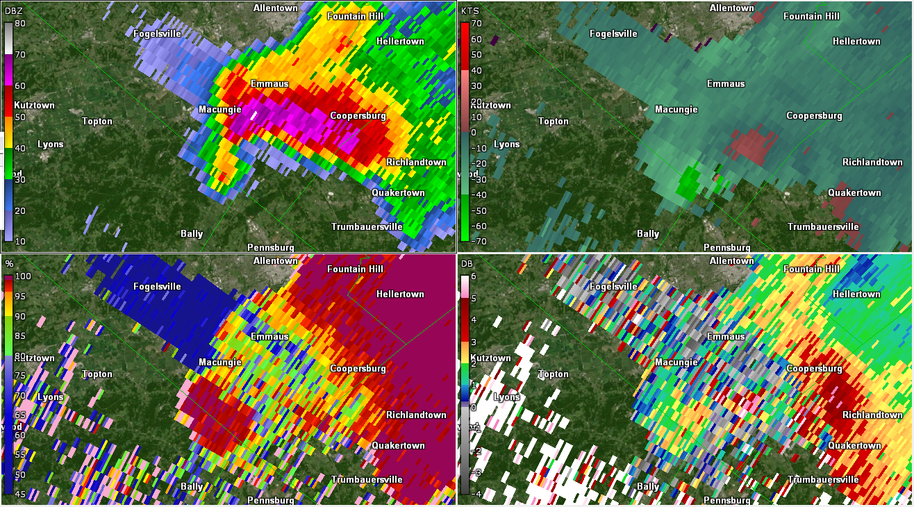
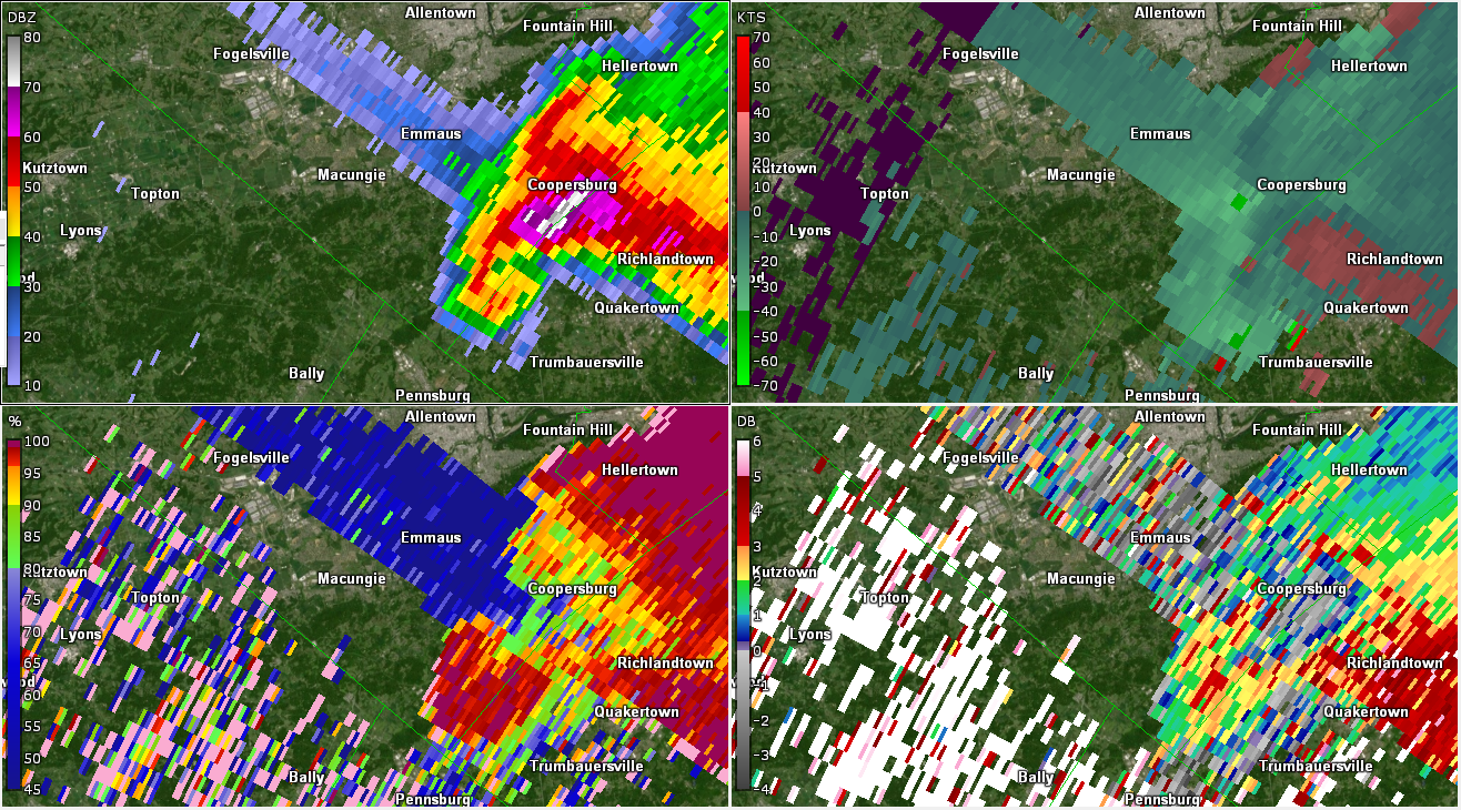
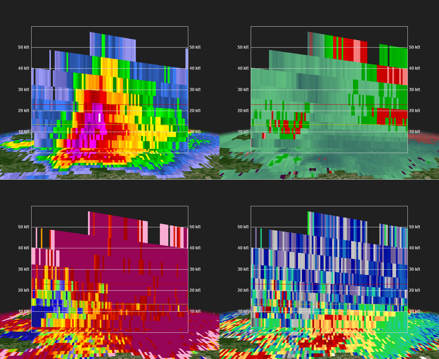
Lehigh/Bucks County Tornado and Very Large Hail (GR2Analyst)
 |
 |
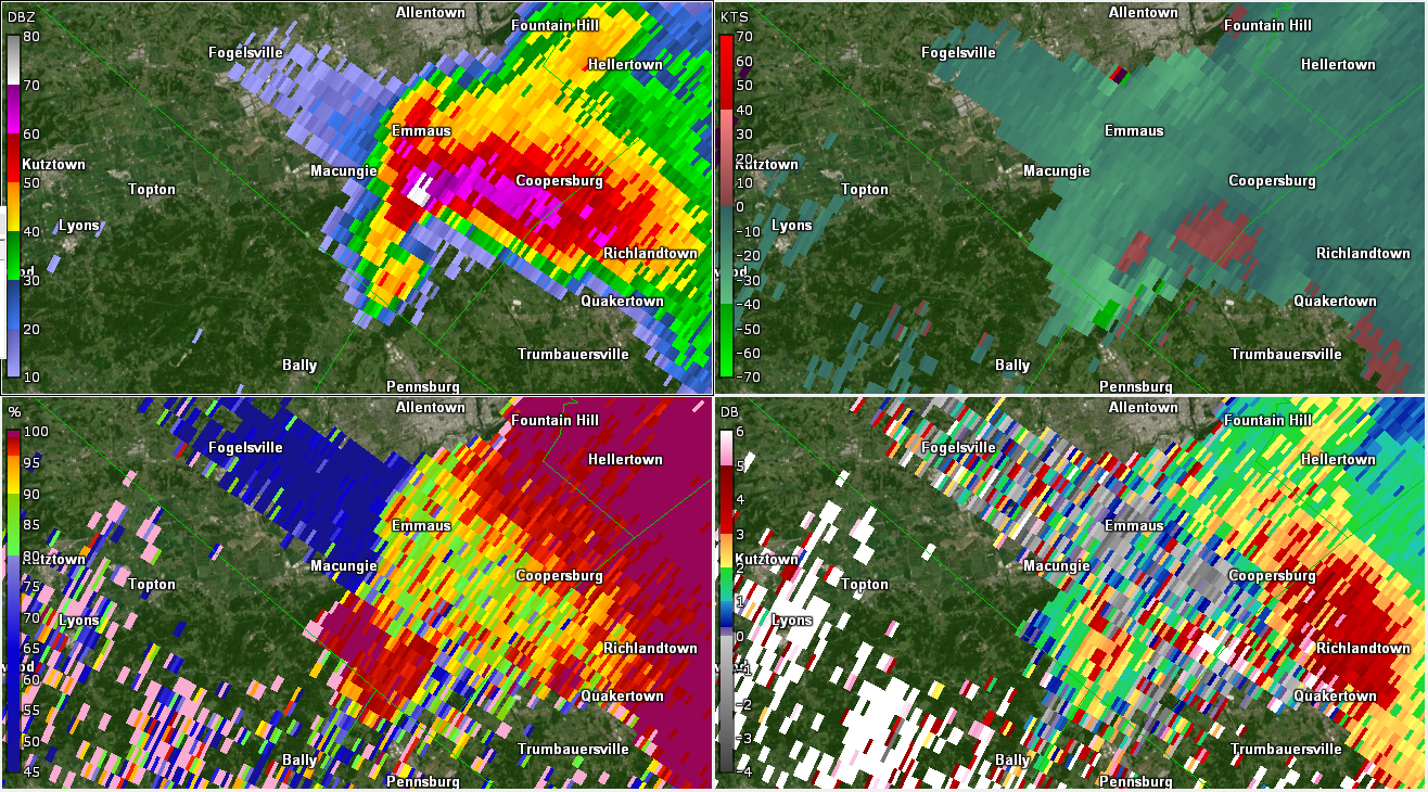 |
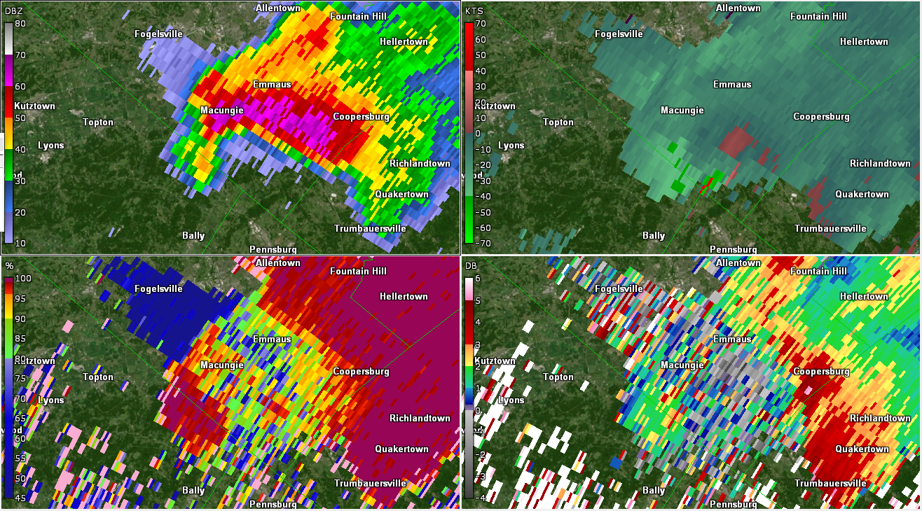
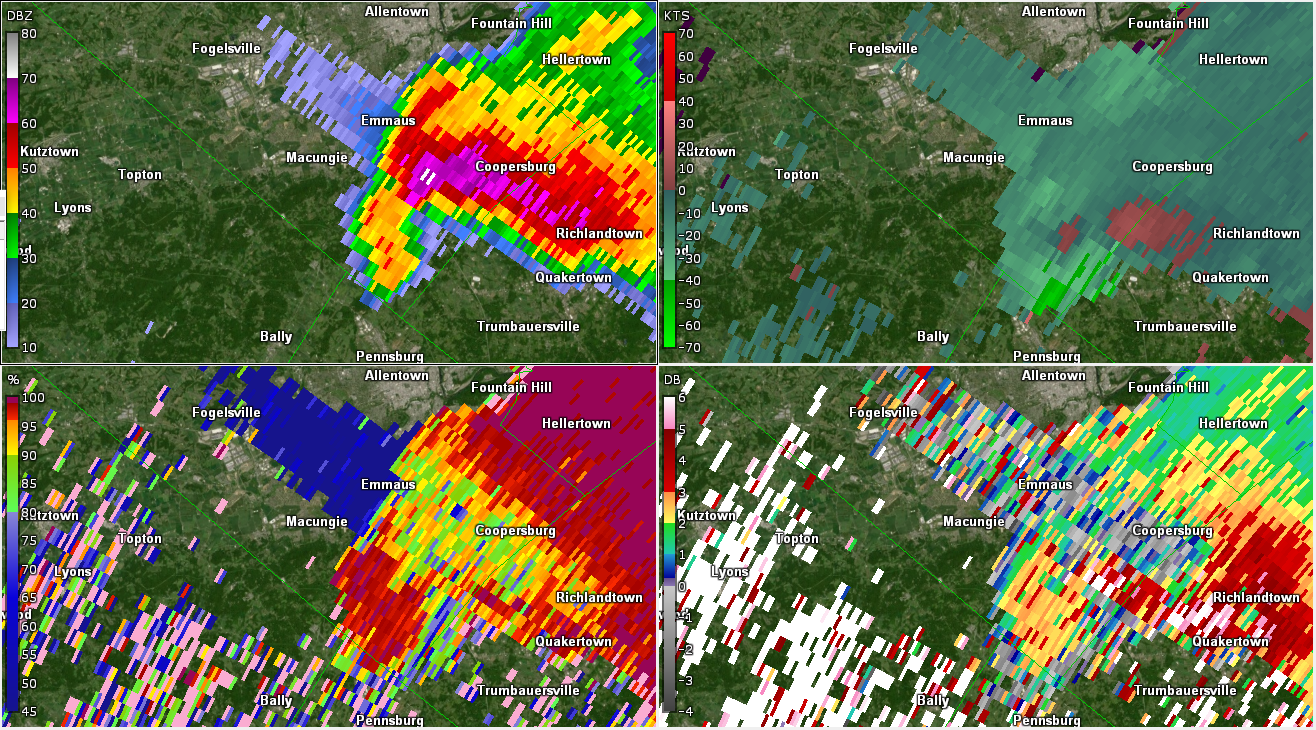
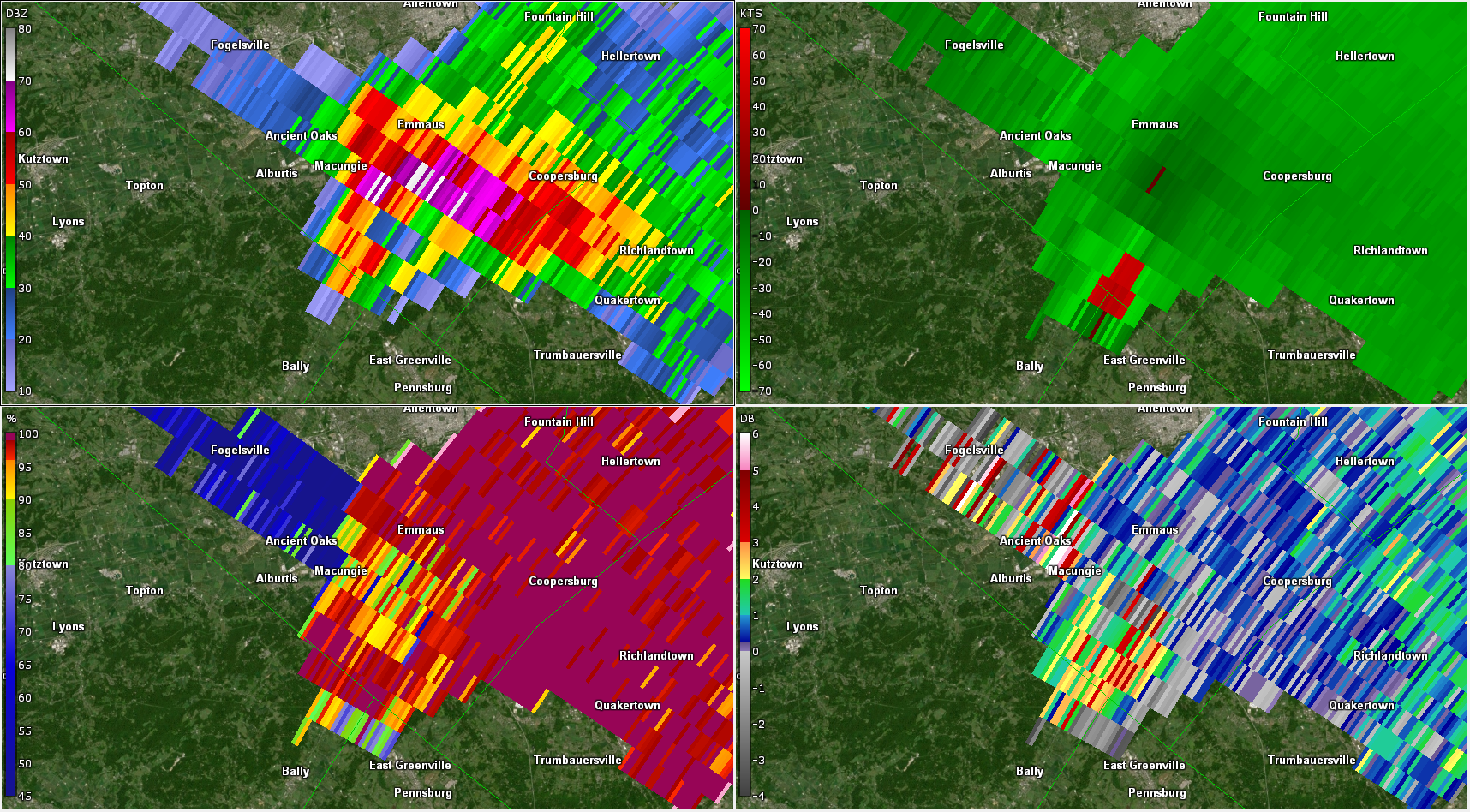
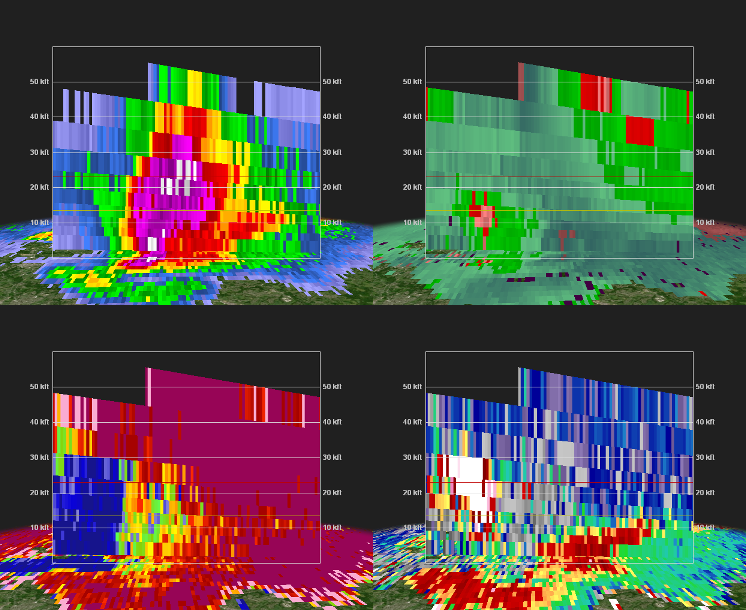
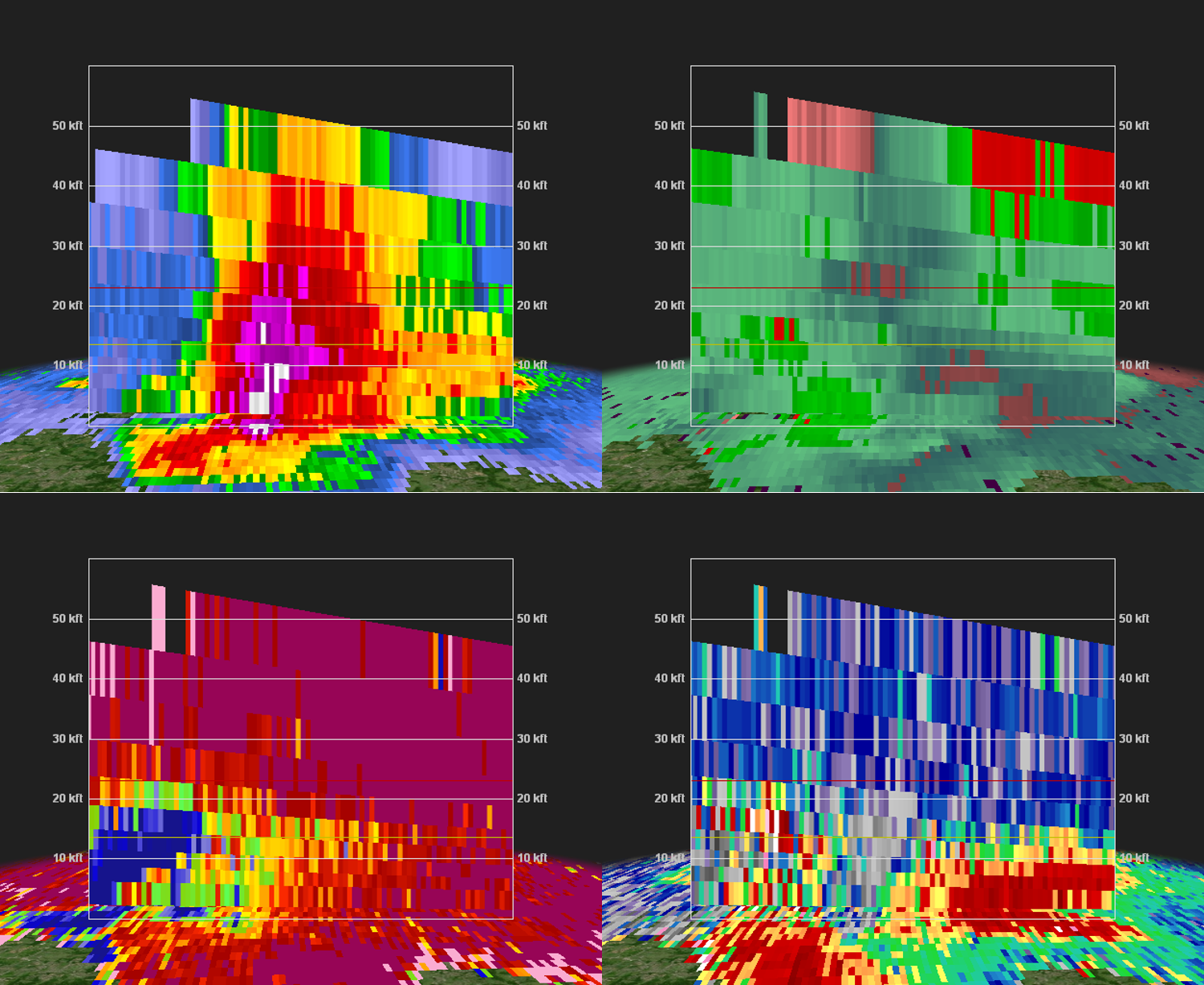
| Figure 1: KDIX radar reflectivity factor (top left), storm-relative motion (SRM; top right), correlation coefficient (CC; bottom left), and differential reflectivity (ZDR; bottom right) valid at 1909 UTC on 29 May 2019. This intense and very classic-looking supercell had already left a swath of 1-2+ inch hail from Kutztown to Macungie. At this point, radar is displaying easily identifiable signals of very large hail in a corridor from Macungie to Emmaus to Coopersburg: a three-body scatter spike (TBSS; seen in the spike of (low) radar reflectivity and very low CC to the northwest of the supercell) and near-zero ZDR collocated with 65+ dBZ radar reflectivity factor in the forward-flank downdraft region of the supercell. There is also a substantial lowering of CC within the forward-flank downdraft, an indication of non-uniform precipitation/hydrometeors (another hail signal). Note that radar also exhibits broad cyclonic rotation via SRM and an indication of tighter rotation near the hook echo of the storm. | Figure 2: Same as Fig. 1, valid at 1912 UTC on 29 May 2019. The radar reflectivity factor is slowly increasing within the forward-flank downdraft. There also remains a signal of strong/tight rotation near the hook echo of the storm. This was shortly before tornadogenesis in Lower Milford Township in Lehigh County. | Figure 3: Same as Fig. 1, valid at 1914 UTC on 29 May 2019. This was the approximate time of tornadogenesis in Lehigh County. The broader mesocyclonic rotation has increased, the radar reflectivity factor has continued to increase (now to 75 dBZ just east of Macungie), and gate-to-gate shear is slowly increasing near the location of the tornado. |
 |
 |
 |
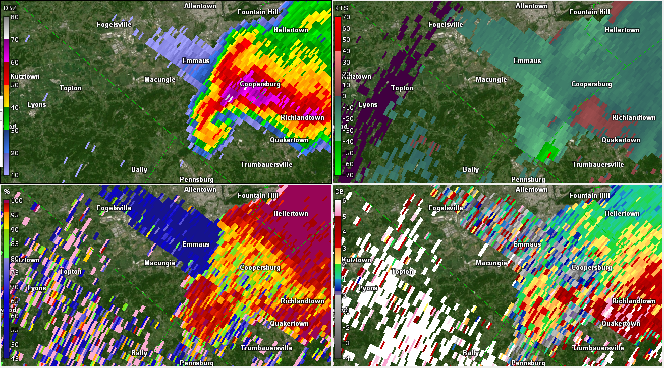
| Figure 4: Same as Fig. 1, valid at 1917 UTC on 29 May 2019. Gate-to-gate shear continues to increase slowly near the Lehigh/Bucks County line as the hail core continues its trek to the north of the tornado track. Two-inch hail was occurring near Coopersburg at this time. | Figure 5: Same as Fig. 1, valid at 1919 UTC on 29 May 2019. This image probably best exhibits the tornado, as low-level rotation is strongest at this point just into Bucks County to the west of Trumbauersville. | Figure 6: Same as Fig. 1, valid at 1921 UTC on 29 May 2019. The tornado dissipated around this time, and the low-level rotation clearly diminished with this radar scan. Note, however, the extremely high radar reflectivity factor observed near Coopersburg. Values approaching 80 dBZ are depicted here, an indication of very large hail. The TBSS has lengthened and is a strong indication of extremely large hail. Notably, this storm reportedly caused over a million dollars in hail damage in the Lehigh Valley. |
 |
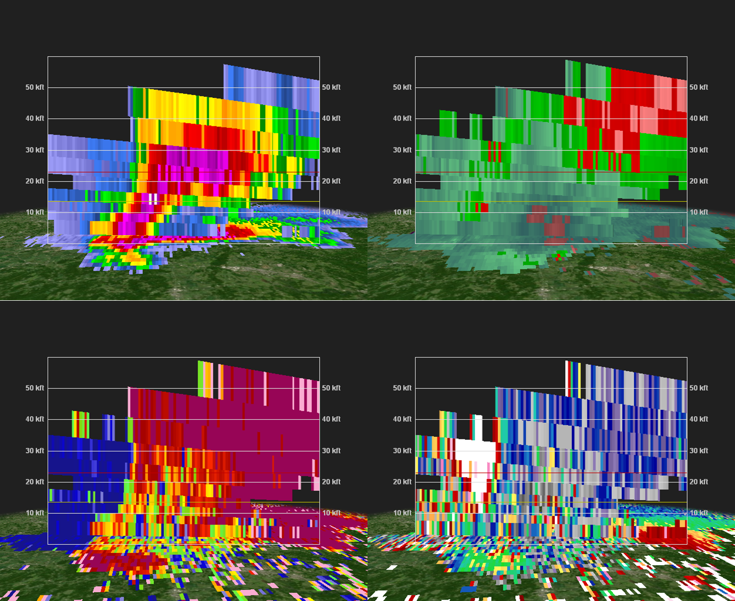 |
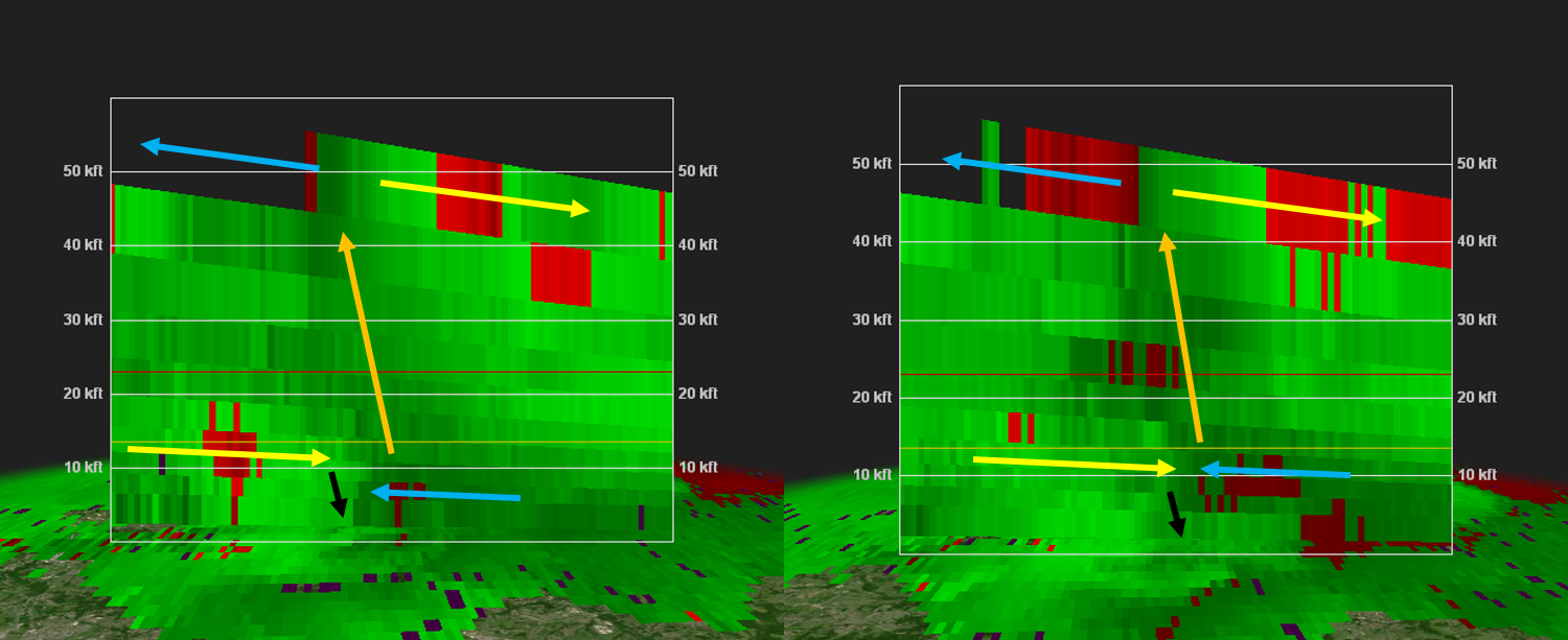
| Bonus Figure 1: KDIX radar reflectivity factor (top left), base velocity, correlation coefficient (CC; bottom left), and differential reflectivity (ZDR; bottom right) valid at 1911 UTC on 29 May 2019 for the 1.8 degree elevation angle (around 10,000 to 13,000 feet above ground level). One obvious signal of the storm's severe nature is the presence of a bounded weak echo region (note the lower radar reflectivity factor surrounded by higher values southeast of Macungie). This suggests an updraft that is shunting precipitation (including hail) upward and outward, which takes very high speeds to do. Additionally, base velocities indicate the updraft is rotating rapidly. A three-body scatter spike is present northwest of the hail on the north side of the updraft. Within the updraft is low CC and relatively low ZDR, an indication of a lack of precipitation (and possibly some non-meteorological echo). | Bonus Figure 2: A cross-section of the storm valid at 1909 UTC on 29 May 2019 (with panels as in Bonus Fig. 1). Note the lower reflectivity (up to 10 kft AGL) below the elevated high-reflectivity values (15-40 kft AGL) and the tilted nature of the reflectivity from the surface to the 20-30 kft levels. This is a strongly sheared storm with an intense updraft, lofting very large hail (as indicated by the 60-70+ dBZ radar reflectivity in the 15-30 kft AGL layer, with a three-body scatter spike on the left side of the cross-section). It is no surprise this storm produced a large swath of 1.5-2+ inch hail in the Lehigh Valley. |
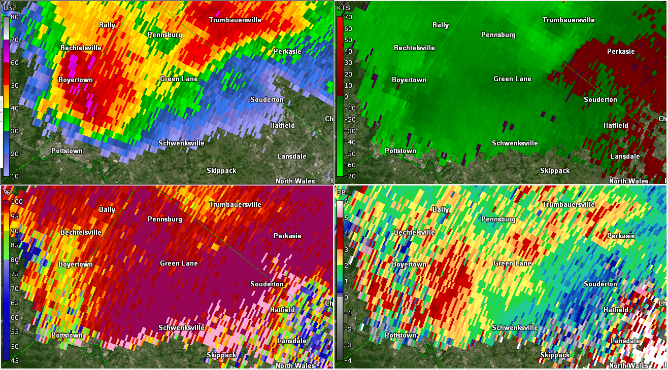
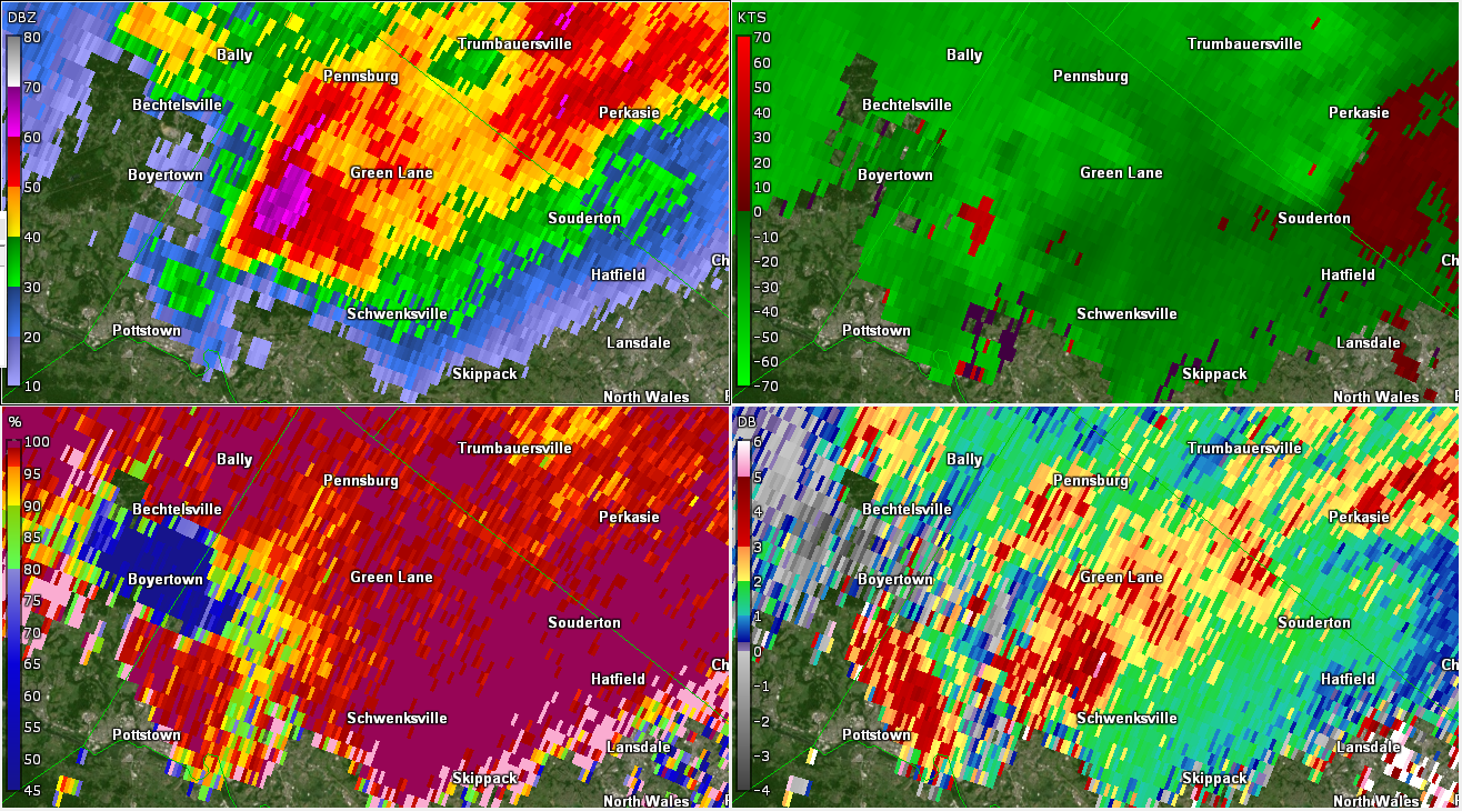
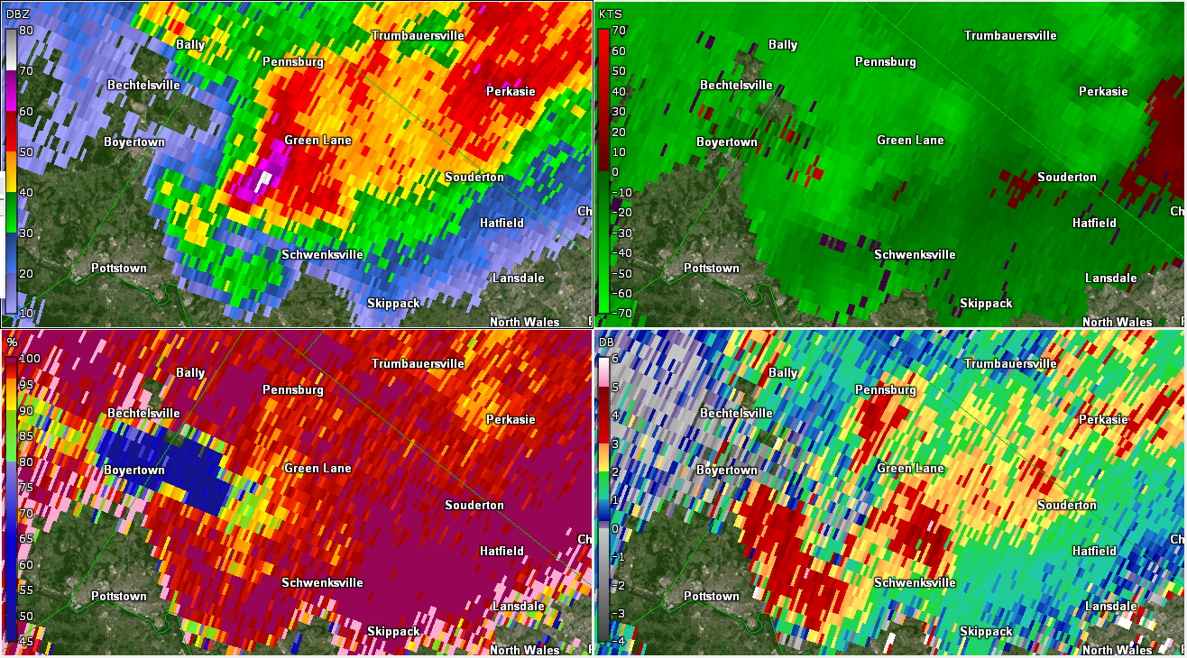
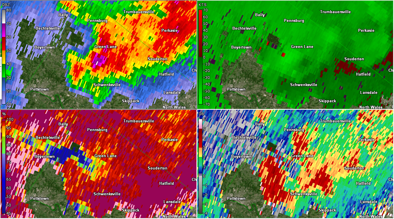
Montgomery County Microburst (GR2Analyst)
 |
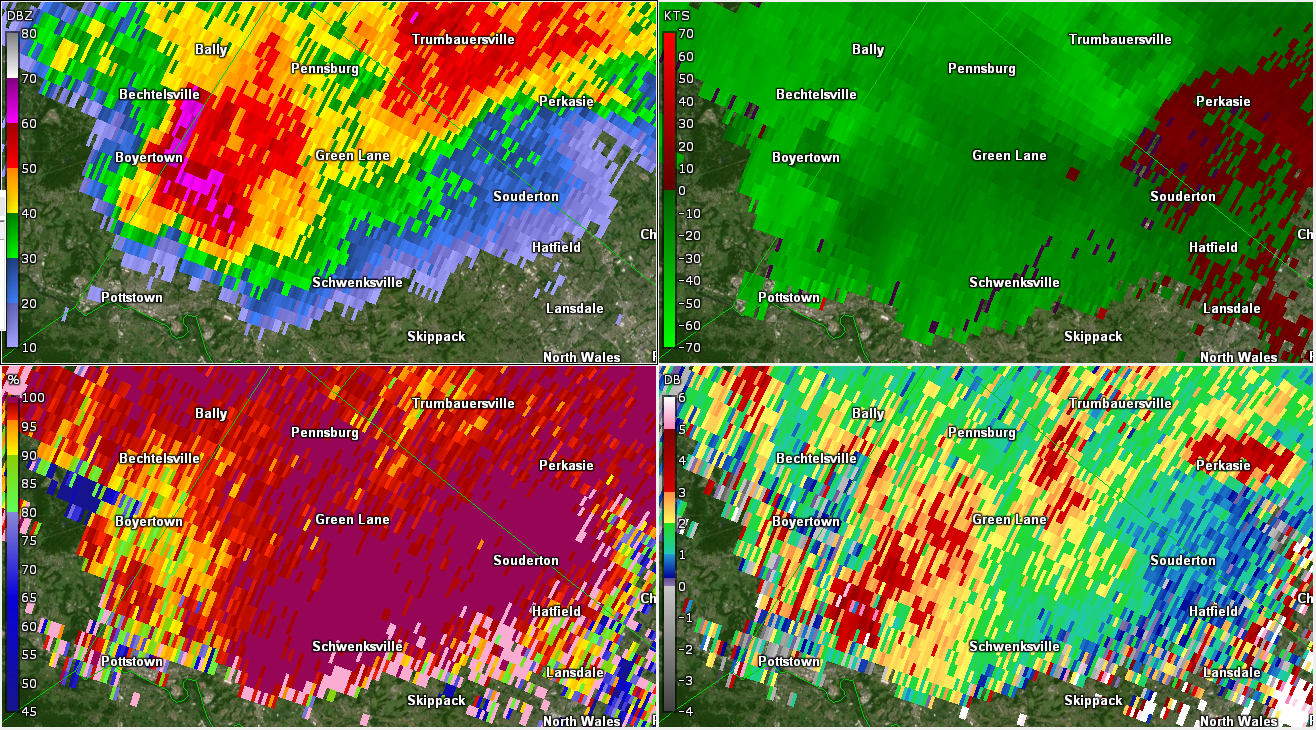 |
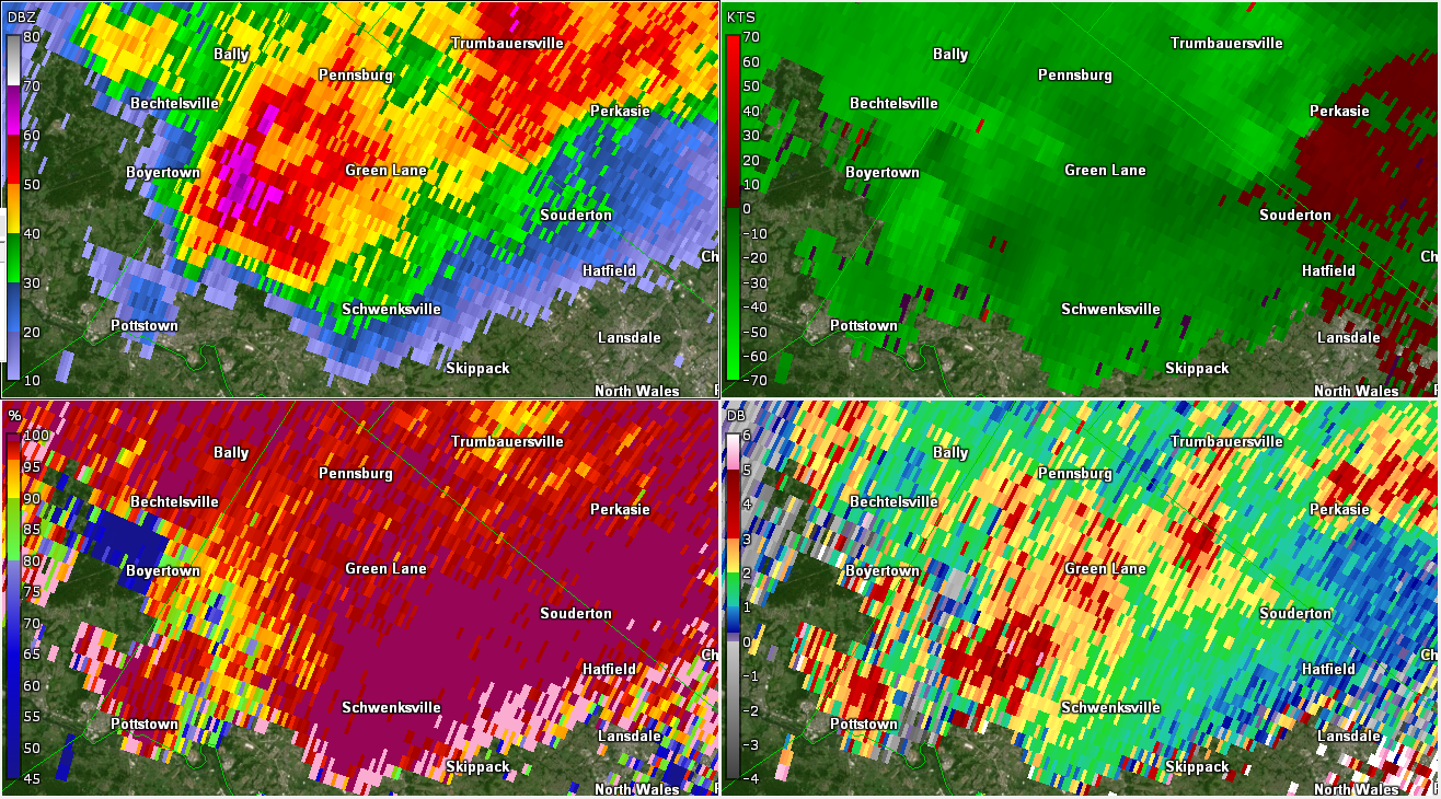 |
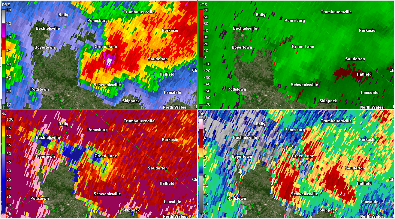
| Figure 7: Same as Fig. 1, valid at 2043 UTC on 29 May 2019 (and using base velocity versus storm-relative motion in the top right panel). A severe storm was over Boyertown at this time, with evidence of a TBSS via very low CC to the northwest of Boyertown (an indication of large hail). ZDR is also quite low in this area, another indication of large hail. Quarter size hail was reported at this time. | Figure 8: Same as Fig. 1, valid at 2045 UTC on 29 May 2019. The radar reflectivity factor was increasing with the storm, and both the near-zero ZDR and the TBSS (via the low CC) were becoming more obvious/distinct. Though not shown, radar imagery aloft suggested an intense core of higher reflectivity was descending rapidly to the surface at this time, a harbinger of a downburst. | Figure 9: Same as Fig. 1, valid at 2048 UTC on 29 May 2019. There are strong indications the most intense portion of the storm is nearing the surface at this point, with a very strong indication of large hail via zero to negative ZDR east of Boyertown collocated with 65+ dBZ radar reflectivity factor. Additionally, base velocities are increasing rapidly in this vicinity (now exceeding 45 kts). |
 |
 |
 |
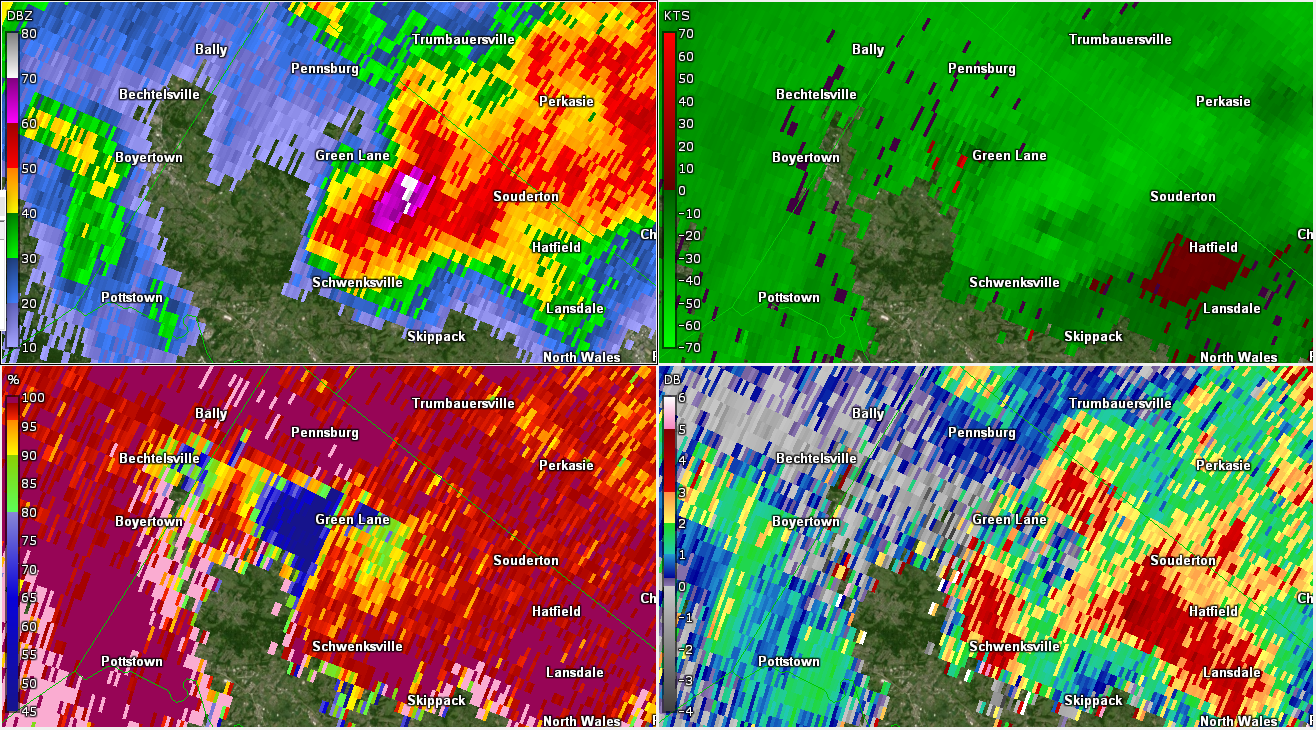
| Figure 10: Same as Fig. 1, valid at 2050 UTC on 29 May 2019. The microburst had reached the surface at this time, with velocity folding quite evident on base velocity. Speeds are 60+ kts on radar at this point (when accounting for the velocity folding), with a very obvious TBSS northwest of the hail core now. Substantial wind damage and numerous reports of large hail occurred between Boyertown and Green Lane around this time. | Figure 11: Same as Fig. 1, valid at 2053 UTC on 29 May 2019. The radar reflectivity factor continues to increase, with 50-60+ kt base velocities on radar continuing west of Green Lane. | Figure 12: Same as Fig. 1, valid at 2056 UTC on 29 May 2019. The hail core was shrinking, but the microburst was still clearly evident here with very high velocities near/southwest of Green Lane collocated with the most intense radar reflectivity and the TBSS and near-zero ZDR. |
 |
 |
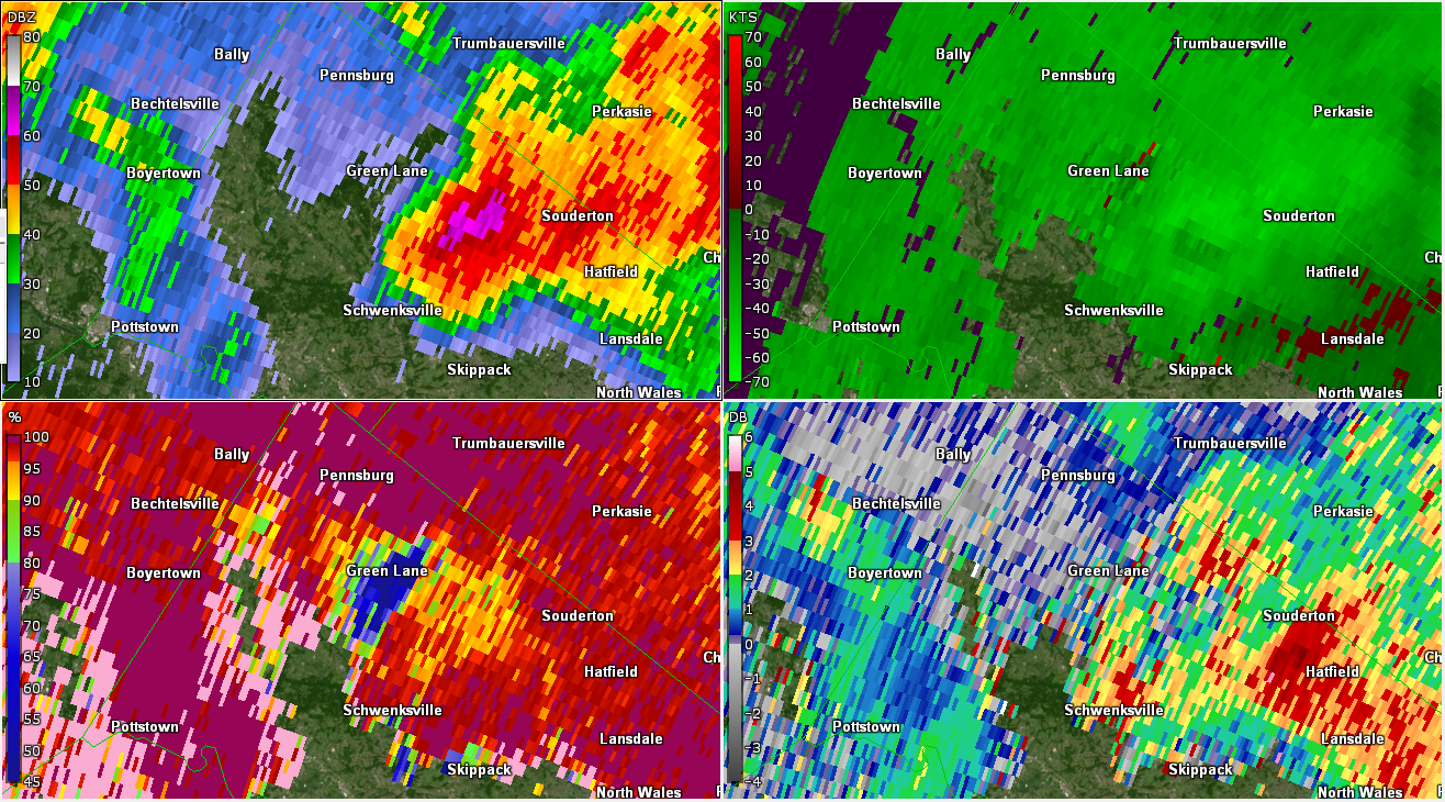 |
| Figure 13: Same as Fig. 1, valid at 2059 UTC on 29 May 2019. The core of the storm is now just south of Green Lane, with 70-75 dBZ radar reflectivity factor values an indication of large hail and intense rainfall. The swath of wind damage continues... | Figure 14: Same as Fig. 1, valid at 2101 UTC on 29 May 2019. The TBSS becomes wider as the core again increases in size. However, the base velocities are beginning to decrease as they also expand, which is fairly typical with microbursts. | Figure 15: Same as Fig. 1, valid at 2104 UTC on 29 May 2019. The trends seen in the previous radar scan continue here, with a broadening base velocity field. The radar reflectivity factor near the core of the storm has decreased markedly, an indication the strongest portion of the downdraft has descended by this point. |
 |
 |
 |
| Figure 16: Cross section of the Montgomery County microburst using KDIX valid at 2048 UTC on 29 May 2019. The top left panel is base reflectivity, the top right panel is storm-relative motion, the bottom left panel is correlation coefficient, and the bottom right panel is differential reflectivity. Radar imagery reveals strong divergence near the top of the storm (40-50 kft AGL; see Fig. 19 below) via outward motion on the west side and inward motion on the east side, convergence closer to the surface (5-20 kft AGL), a deep hail core (as indicated by near-zero ZDR and lowered CC from the surface to 25+ kft AGL and a very obvious three-body scatter spike to the west of the storm, as indicated by very low CC). The convergence around 10-20 kft is a harbinger of a descending precipitation core/downdraft, compounded by intense velocities from west to east on the rear side of the storm (i.e., a rear-inflow jet; see Fig. 19). | Figure 17: As in Figure 16, valid at 2053 UTC on 29 May 2019. Radar reflectivity factor has increased markedly aloft, as has the signal for convergence in the 5-20 kft level. The most intense portion of the downburst will reach the surface soon. Velocities in the rear-inflow jet (Fig. 19) are approaching 100 kts. | Figure 18: As in Figure 16, valid at 2059 UTC on 29 May 2019. The most intense radar reflectivity factors have now reached the surface. This is the time in which the most significant wind damage with the storm occurred, per numerous reports from the public, spotters, and media. Note that the convergence aloft is descending toward the surface as well. Additionally, the divergence signal near the top of the storm continues to increase, and is well in excess of 100 kts at this time. |
 |
||
| Figure 19: Cross section of base velocities for the Montgomery County microburst using KDIX valid at 2053 UTC (left) and 2059 UTC (right) on 29 May 2019. The arrows indicate the direction of flow as implied by the radar displays. The convergence (yellow arrow west-to-east and cyan arrow east-to-west) implies upward motion above and downward motion below, whereas the divergence aloft (arrows reversed) confirm upward motion from ~10 kft AGL to storm top. Base velocities at 2053 UTC to the rear of the storm (yellow arrow around 10-20 kft AGL) are approaching 100 kts; this is the rear-inflow jet. These intense winds are forced downward when the flow converges with the east-to-west flowing air downstream of the storm. By 2059 UTC, the rear-inflow jet has weakened and is an indication the winds have been forced downward to the surface (via the radar reflectivity factor being highest near the surface at this time; see Fig. 18). | ||
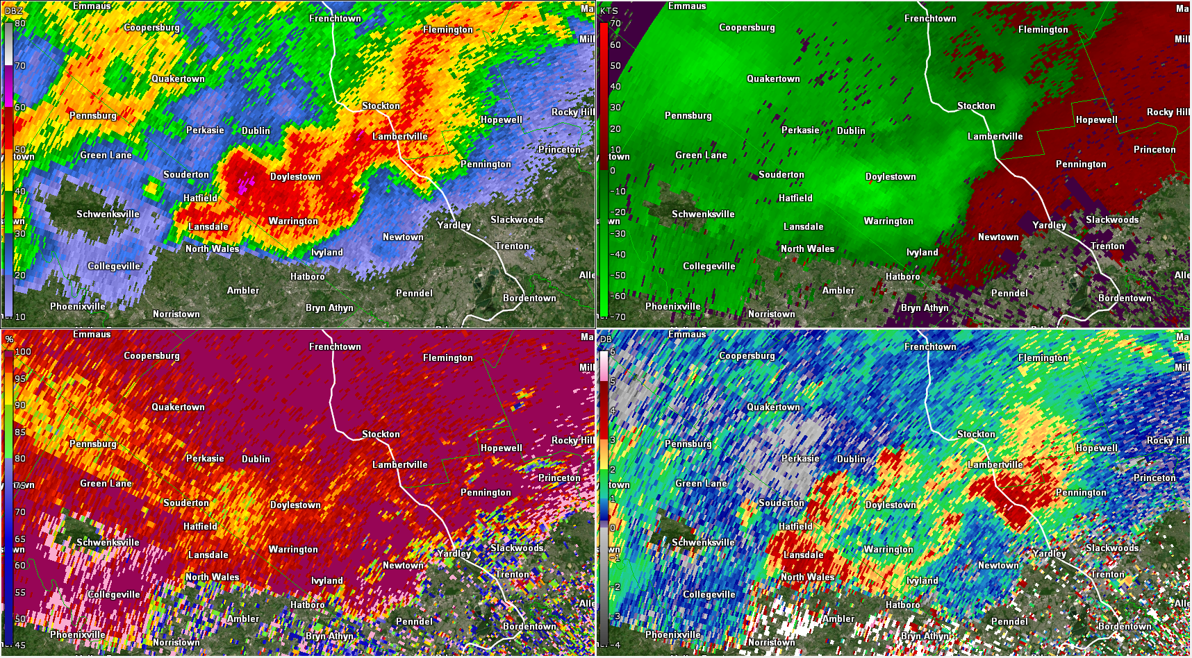
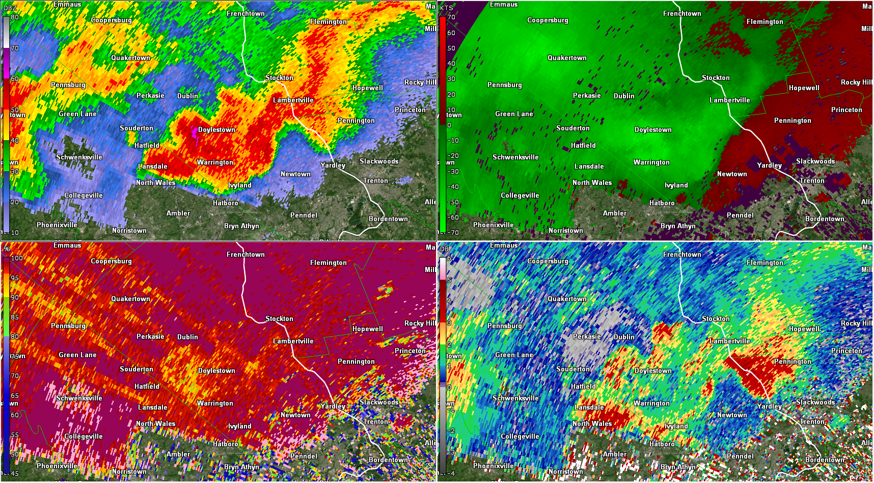
Doylestown Microburst (GR2Analyst)
 |
 |
 |
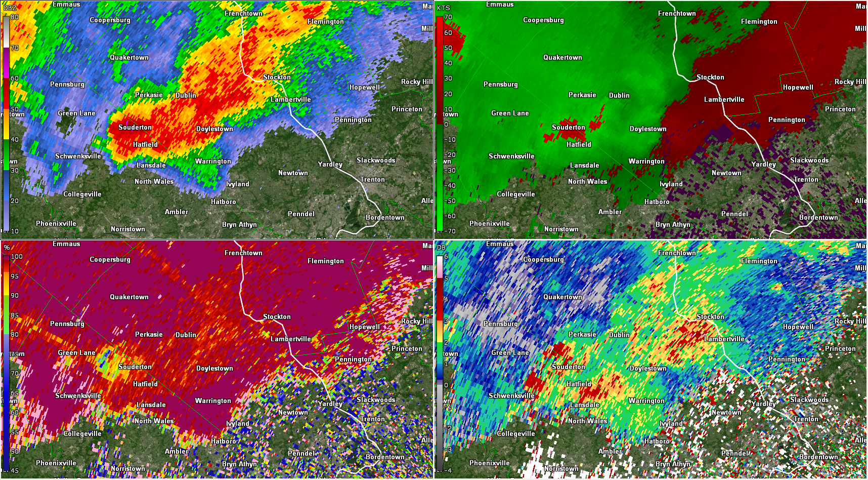
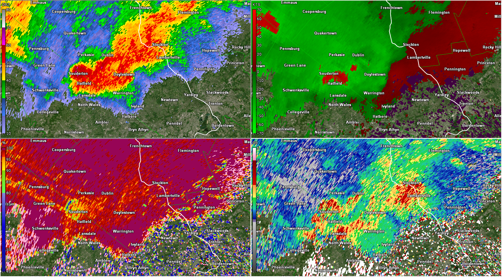
| Figure 20: Same as Fig. 1, valid at 2109 UTC on 29 May 2019 (and using base velocity versus storm-relative motion in the top right panel). Storms were beginning to congeal during this phase of the event, with the same storm that produced the intense microburst in Montgomery County (now near Souderton) congealing with a supercell near Doylestown. Base velocities were very high (60+ kts, when accounting for velocity folding) near Souderton, indicative of very strong winds that were likely reaching the surface. There are indications of a three-body scatter spike just northwest of Souderton, with ZDR suggesting hail is present as well. Up to quarter-size hail was reported with the storm, with radar indicating a mix of heavy rain and hail in the most intense portion of the storm. Note also the convergence (red/outbund velocities to the southeast; green/inbound velocities to the northwest near the reflectivity gradient of the supercell in Doylestown. As the storm's outflow continues to become stronger (via an intensifying cold pool associated with the downdraft), the supercell will continue to lose its (discrete) character. | Figure 21: Same as Fig. 1, valid at 2111 UTC on 29 May 2019. The strongest winds are between Souderton and Doylestown, with continued lower CC and ZDR in the Souderton vicinity. | Figure 22: Same as Fig. 1, valid at 2114 UTC on 29 May 2019. The strongest winds are just west of Doylestown, with the most intense portion of the precipitation now entering Bucks County. |
 |
 |
 |
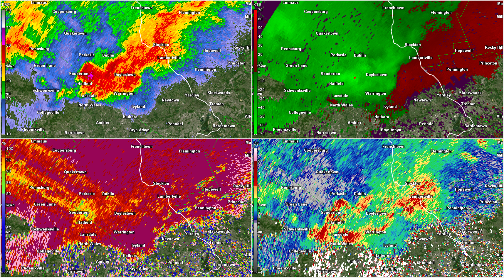
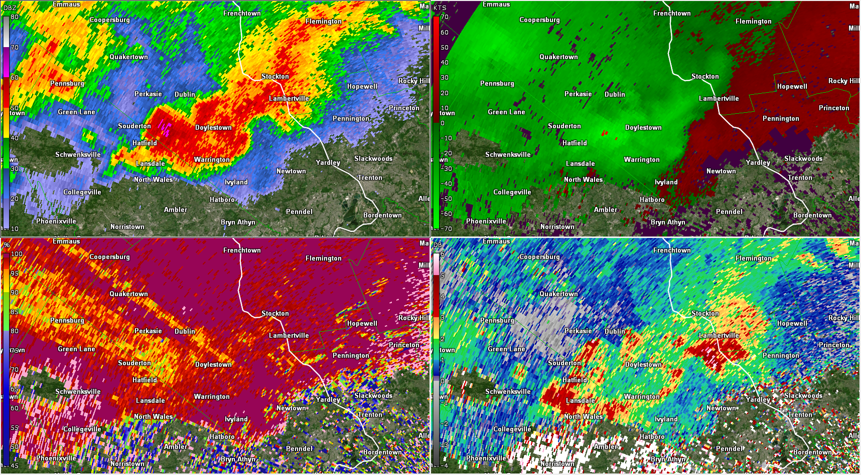
| Figure 23: Same as Fig. 1, valid at 2117 UTC on 29 May 2019. The microburst is progressing toward the southwest side of Doylestown at this point, with some indication of lower CC and ZDR approaching the west side of Doylestown as well (an indication of hail mixing with rain). Note also the high ZDR south of Lambertville, an indication of very large raindrops. | Figure 24: Same as Fig. 1, valid at 2119 UTC on 29 May 2019. The most intense precipitation is now just southwest of Doylestown, with the strongest winds just east of that precipitation core. | Figure 25: Same as Fig. 1, valid at 2122 UTC on 29 May 2019. The rain/hail core had reached Doylestown, and the strongest winds are likely occurring in the Doylestown area at this time. Widespread wind damage was reported here, as well as hail up to quarter size. |


 Coastal Flood
 Marine Forecasts
 Text Products
 Climate Information
 Skywarn
 Submit Storm Report
 Weather Event Archives
 Forecast Discussion
 Emergency Managers
 Briefing Page