
A heat wave over the Southwest will intensify this week, peaking and expanding into the Intermountain West and northern High Plains this weekend. Critical to extremely critical fire weather conditions are forecast from the Northwest and the northern Great Basin this weekend. Particularly Dangerous Situation Red Flag Warnings have been issued. Read More >
Overview
|
Scattered thunderstorms developed in a broad region of moist and unstable air in the Appalachians and Mid-Atlantic, aided by a midlevel shortwave trough ejecting northeastward from the Ohio Valley. Deep-layer shear was sufficient for storm organization in the form of clusters and even isolated supercells. Additionally, the atmosphere was quite unstable during the afternoon and evening, allowing for the development of strong updrafts capable of generating hail. Sporadic instances of wind damage and marginally severe hail occurred in the Poconos, northwest New Jersey, the Lehigh Valley, and adjacent areas to the south and east during the evening hours. A brief EF1 tornado developed in Bucks County late in the evening as well. This event posed a particular challenge to the office, as the KDIX Doppler radar had a severe hardware failure and was unavailable for this event.
|
 Composite radar loop during the afternoon/evening of 19 May 2019. |
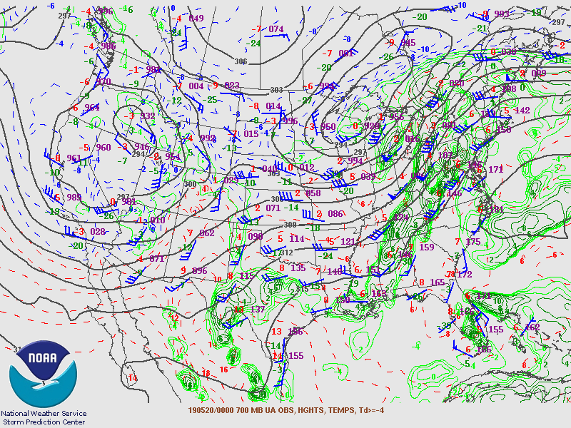
Synoptic Overview at 12z 19 May 2019 (courtesy of SPC)
 |
 |
 |
| Figure 1: 250-mb analysis | Figure 2: 300-mb analysis | Figure 3: 500-mb analysis |
 |
 |
 |
| Figure 4: 700-mb analysis | Figure 5: 850-mb analysis | Figure 6: 925-mb analysis |
Synoptic Overview at 00z 20 May 2019 (courtesy of SPC)
 |
 |
 |
| Figure 7: 250-mb analysis | Figure 8: 300-mb analysis | Figure 9: 500-mb analysis |
 |
 |
 |
| Figure 10: 700-mb analysis | Figure 11: 850-mb analysis | Figure 12: 925-mb analysis |
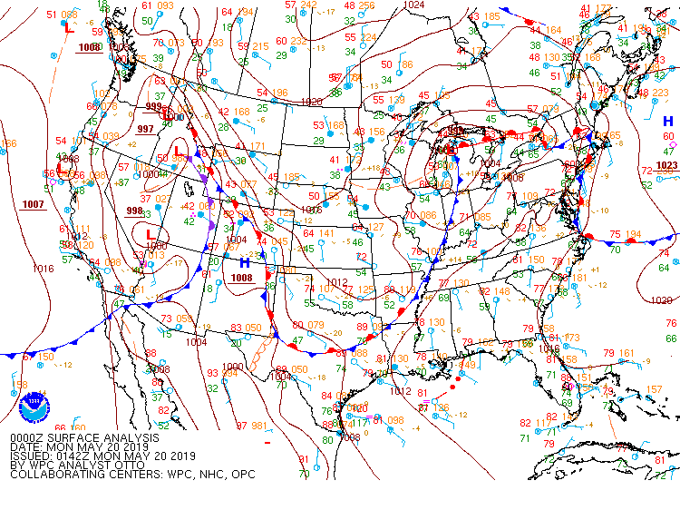
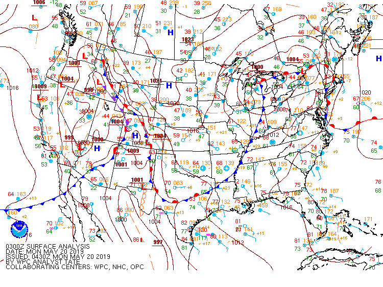
Surface Maps (courtesy of WPC)
 |
 |
 |
| Figure 13: 15z surface map | Figure 14: 18z surface map | Figure 15: 21z surface map |
 |
 |
 |
| Figure 16: 00z surface map | Figure 17: 03z surface map | Figure 18: 06z surface map |
 |
 |
 |
| Figure 19: 12z Upton, NY sounding | Figure 20: 12z Sterling, VA sounding | Figure 21: 12z Pittsburgh, PA sounding |
 |
 |
 |
| Figure 22: 00z Upton, NY sounding | Figure 23: 00z Sterling, VA sounding | Figure 24: 00z Pittsburgh, VA sounding |
 |
 |
 |
| Figure 1: National Preliminary Reports 12z 19 May 2019 to 12z 20 May 2019 | Figure 2: Zoomed Preliminary Reports for the same period. | Figure 3: Prelim Reports vs. 1630z SPC Convective Outlook |
Severe Thunderstorm Watch 0193
Severe Thunderstorm Warning 0030
Severe Thunderstorm Warning 0031
Severe Thunderstorm Warning 0032
Severe Thunderstorm Warning 0033
Severe Thunderstorm Warning 0034
Tornado Warning 0008
Severe Thunderstorm Warning 0035
Severe Thunderstorm Warning 0036
Severe Thunderstorm Warning 0037
Areal Flood Advisory 0050
Severe Thunderstorm Warning 0038
Severe Thunderstorm Warning 0039
Severe Thunderstorm Warning 0040
Areal Flood Advisory 0051
Areal Flood Advisory 0052
NWUS51 KPHI 201524
LSRPHI

PRELIMINARY LOCAL STORM REPORT...SUMMARY
NATIONAL WEATHER SERVICE MOUNT HOLLY NJ
1124 AM EDT MON MAY 20 2019

..TIME...   ...EVENT...      ...CITY LOCATION...     ...LAT.LON...
..DATE...   ....MAG....      ..COUNTY LOCATION..ST.. ...SOURCE....
            ..REMARKS..

1230 AM     TSTM WND DMG     1 NW DENVILLE           40.87N 74.50W
05/20/2019                   MORRIS             NJ   TRAINED SPOTTER

            MULTIPLE LARGE TREES UPROOTED AND SEVERAL
            SMALL PINE TREES SNAPPED.

1136 PM     HAIL             BRODHEADSVILLE          40.93N 75.39W
05/19/2019  E1.00 INCH       MONROE             PA   TRAINED SPOTTER

            NICKEL TO QUARTER SIZE HAIL.

0951 PM     TORNADO          2 NE OTTSVILLE          40.49N 75.14W
05/19/2019                   BUCKS              PA   NWS STORM SURVEY

            A STORM SURVEY TEAM DETERMINED A TORNADO
            BRIEFLY TOUCHED DOWN OVER THE BEAVER VALLEY
            CAMPGROUNDS IN TINICUM TOWNSHIP, BUCKS
            COUNTY, PA NEAR OTTSVILLE ON SUNDAY EVENING.
            THE TORNADO TRACKED FROM SOUTHWEST TO
            NORTHEAST ACROSS THE PROPERTY FOR
            APPROXIMATELY ONE QUARTER OF A MILE WITH A
            MAXIMUM PATH WIDTH OF ABOUT 100 YARDS. THE
            TORNADO WAS ON THE GROUND FOR APPROXIMATELY
            ONE MINUTE. DOZENS OF TREES WERE UPROOTED
            WITH SEVERAL TREES SNAPPED IN A MANNER
            CONSISTENT WITH TORNADIC WINDS. THE TORNADO
            REACHED ITS MAXIMUM WIDTH AND INTENSITY NEAR
            THE END OF ITS PATH WHERE THREE CAMPING
            TRAILERS WERE SIGNIFICANTLY DAMAGED BY
            FALLEN TREES.

0947 PM     FLOOD            1 SSW LAURELDALE        40.37N 75.93W
05/19/2019                   BERKS              PA   FIRE DEPT/RESCUE

            ROUTE 12 BETWEEN ROUTE 61 AND N 5TH STREET
            HIGHWAY CLOSED DUE TO FLOODING.

0946 PM     TSTM WND DMG     POHATCONG TWP           40.65N 75.14W
05/19/2019                   WARREN             NJ   911 CALL CENTER

            NUMEROUS TREES AND POWER LINES REPORTED DOWN
            ACROSS THE TOWNSHIP.

0940 PM     TSTM WND DMG     2 S GLENDON             40.64N 75.24W
05/19/2019                   NORTHAMPTON        PA   BROADCAST MEDIA

            *** 1 INJ ***
            LARGE TREE DOWN ONTO A HOUSE IN THE 2700
            BLOCK OF MORGAN HILL ROAD IN WILLIAMS
            TOWNSHIP. A SECTION OF THE HOME WAS
            ESSENTIALLY DESTROYED. A WOMAN IN THE HOME
            HAD MINOR INJURIES. TIME ESTIMATED FROM
            RADAR.

0917 PM     TSTM WND DMG     BOYERTOWN               40.33N 75.64W
05/19/2019                   BERKS              PA   FIRE DEPT/RESCUE

            TREE AND POWER LINES DOWN ON E PHILADELPHIA
            AVENUE. TIME ESTIMATED FROM RADAR.

0915 PM     FLOOD            WYOMISSING              40.34N 75.96W
05/19/2019                   BERKS              PA   FIRE DEPT/RESCUE

            WATER RESCUE UNDER THE RAILROAD BRIDGE AT
            STATE HILL ROAD.

0915 PM     TSTM WND DMG     1 WNW WASHINGTON TWP    40.40N 75.61W
05/19/2019                   BERKS              PA   FIRE DEPT/RESCUE

            TREE DOWN ON WIRES ON FORGE DALE ROAD. TIME
            ESTIMATED FROM RADAR.

0914 PM     TSTM WND DMG     1 SSE BECHTELSVILLE     40.36N 75.62W
05/19/2019                   BERKS              PA   FIRE DEPT/RESCUE

            TREE DOWN ON TOWNSHIP LINE ROAD 1 MILE FROM
            ROUTE 100. TIME ESTIMATED FROM RADAR.

0910 PM     LIGHTNING        1 ENE WERNERSVILLE      40.33N 76.07W
05/19/2019                   BERKS              PA   FIRE DEPT/RESCUE

            LIGHTNING STRIKE TO A RESIDENCE ON N PENN
            DRIVE.

0901 PM     TSTM WND DMG     1 WNW TEMPLE            40.41N 75.94W
05/19/2019                   BERKS              PA   FIRE DEPT/RESCUE

            TREE DOWN IN BERN TWP NEAR ROUTE 61 AND
            CROSS KEYS ROAD. TIME ESTIMATED FROM RADAR.

0857 PM     HAIL             SINKING SPRING          40.33N 76.02W
05/19/2019  E1.00 INCH       BERKS              PA   PUBLIC

            QUARTER SIZE HAIL AND ESTIMATED 30-40 MPH
            WIND GUSTS REPORTED IN SINKING SPRING. TIME
            ESTIMATED FROM RADAR.

0851 PM     TSTM WND GST     LAURELDALE              40.39N 75.92W
05/19/2019  E60 MPH          BERKS              PA   TRAINED SPOTTER

            TRAINED SPOTTER ESTIMATED 60 TO 65 MPH WIND
            GUSTS WITH VERY HEAVY RAINFALL AND NO HAIL.

0844 PM     FLOOD            LAURELDALE              40.39N 75.92W
05/19/2019                   BERKS              PA   FIRE DEPT/RESCUE

            NORTH 5TH STREET HIGHWAY CLOSED AT THE ARBYS
            DUE TO FLOOD WATERS.

0831 PM     TSTM WND DMG     1 N EXETER TWP          40.33N 75.84W
05/19/2019                   BERKS              PA   FIRE DEPT/RESCUE

            LARGE TREE DOWN ACROSS OLEY TURNPIKE ROAD
            BETWEEN WOODS LANE AND RITTERS LANE. ROAD IS
            COMPLETELY BLOCKED AND LOVE POWER LINES ARE
            DOWN.

0826 PM     HAIL             WYOMISSING              40.33N 75.96W
05/19/2019  E1.00 INCH       BERKS              PA   PUBLIC

            DIME TO QUARTER SIZE HAIL IN THE WYOMISSING
            AREA.

0820 PM     TSTM WND DMG     BERN TWP                40.39N 76.00W
05/19/2019                   BERKS              PA   FIRE DEPT/RESCUE

            TREE AND OTHER DEBRIS DOWN ON ROUTE 222 AT
            TULPEHOCKEN BRIDGE. TIME ESTIMATED FROM
            RADAR.

0813 PM     TSTM WND DMG     2 ENE SOUTH HEIDELBERG  40.30N 76.04W
05/19/2019                   BERKS              PA   FIRE DEPT/RESCUE

            TREE DOWN ON A RESIDENCE ON MILLER ROAD.

0810 PM     TSTM WND DMG     1 N HEIDELBERG TWP      40.38N 76.17W
05/19/2019                   BERKS              PA   FIRE DEPT/RESCUE

            MULTIPLE TREES AND POWER POLES DOWN. TIME ESTIMATED
            FROM RADAR.

0805 PM     TSTM WND DMG     3 W BRANCHVILLE         41.15N 74.81W
05/19/2019                   SUSSEX             NJ   911 CALL CENTER

            TREE DOWN ON E SHORE ROAD NEAR LAKE OWASSA.
            TIME ESTIMATED FROM RADAR.

0800 PM     TSTM WND DMG     1 NNE SANDYSTON TWP     41.23N 74.82W
05/19/2019                   SUSSEX             NJ   911 CALL CENTER

            TREE DOWN ON LAYTON-HAINESVILLE ROAD IN
            SANDYSTON TWP. TIME ESTIMATED FROM RADAR.

0715 PM     TSTM WND DMG     POCONO TWP              41.04N 75.30W
05/19/2019                   MONROE             PA   911 CALL CENTER

            TREE DOWN ON TRAILER WITH OCCUPANTS IN
            POCONO TWP. NO KNOWN INJURIES AT THIS TIME.
            STADDEN RD ALSO CLOSED WITH TREE DOWN.

0655 PM     TSTM WND DMG     KIDDER TWP              41.07N 75.72W
05/19/2019                   CARBON             PA   911 CALL CENTER

            TREE DOWN IN KIDDER TWP.

0650 PM     LIGHTNING        1 NNW MAHONING TWP      40.82N 75.76W
05/19/2019                   CARBON             PA   BROADCAST MEDIA

            LIGHTNING STRIKE TO A GARAGE ON HEMLOCK
            DRIVE IN MAHONING TOWNSHIP RESULTING IN A
            FIRE. AT LEAST 5 STRUCTURES WERE HIT BY
            LIGHTNING IN CARBON COUNTY.

0648 PM     TSTM WND DMG     TOWAMENSING TWP         40.88N 75.58W
05/19/2019                   CARBON             PA   PUBLIC

            TREE DOWN IN TOWAMENSING TWP.

0640 PM     TSTM WND DMG     JIM THORPE              40.88N 75.73W
05/19/2019                   CARBON             PA   911 CALL CENTER

            TREE DOWN IN JIM THORPE TWP.


&&

$$

GORSE/STAARMANN/TCD
NOUS41 KPHI 231441
PNSPHI
NJZ007-009-010-015-017>019-027-PAZ054-055-060>062-070-071-101>106-
240245-

Public Information Statement
National Weather Service Mount Holly NJ
1041 AM EDT Thu May 23 2019

...NWS DAMAGE SURVEY FOR 05/19/19 BUCKS COUNTY PA TORNADO...

Start Location...Tinicum Township in Bucks County PA
End Location...Tinicum Township in Bucks County PA
Date...May 19, 2019
Estimated Time...9:51 PM EDT
Maximum EF-Scale Rating...EF1
Estimated Maximum Wind Speed...95 mph
Maximum Path Width...100 yards
Path Length...0.25 miles
Beginning Lat/Lon...40.4929/-75.1404
Ending Lat/Lon...40.4951/-75.1363
* Fatalities...0
* Injuries...0

...Summary...
A storm survey team determined a tornado briefly touched down over
the Beaver Valley Campgrounds in Tinicum Township, Bucks County, PA
near Ottsville on Sunday evening. The tornado tracked from southwest
to northeast across the property for approximately one quarter of a
mile with a maximum path width of about 100 yards. The tornado was
on the ground for approximately one minute. Dozens of trees were
uprooted with several trees snapped in a manner consistent with
tornadic winds. The tornado reached its maximum width and intensity
near the end of its path where three camping trailers were
significantly damaged by fallen trees. Fortunately, no injuries were
reported as a result of this tornado.

EF Scale: The Enhanced Fujita Scale classifies tornadoes into the
following categories:

EF0...Weak......65 to 85 mph
EF1...Weak......86 to 110 mph
EF2...Strong....111 to 135 mph
EF3...Strong....136 to 165 mph
EF4...Violent...166 to 200 mph
EF5...Violent...>200 mph

* The information in this statement is preliminary and subject to
change pending final review of the event and publication in NWS
Storm Data.

$$

Kruzdlo/O'Brien/Staarmann
Berks County Hail (GR2Analyst)
 |
 |
| Figure 1: KCCX radar reflectivity factor (top left), base velocity (top right), correlation coefficient (bottom left), and differential reflectivity (bottom right) valid at 0024 UTC on 20 May 2019. Note the position of a red marker on the four-panel plot. This is approximately the location on radar where large hail is indicated. A lowering of correlation coefficient beyond (east-southeast) of the marker is potentially indicative of a three-body scatter spike and non-uniform beam filling, both of which (can) indicate the presence of hail. Indeed, quarter-sized hail was reported at around this time. | Figure 2: Same as Fig. 1, valid at 0055 UTC on 20 May 2019. The combination of high radar reflectivity factor, low differential reflectivity, a lowering of correlation coefficient (particularly near and southeast of the indicated marker), and divergence (as indicated by red base velocities to the west-northwest of green velocities) suggest the presence of a descending hail core. Quarter-sized hail was reported at Sinking Spring in Berks County at this time. |
Bucks County Tornado (GR2Analyst)
 |
| Figure 3: Same as Fig. 1, valid at 0151 UTC on 20 May 2019 (storm-relative velocities are shown instead of base velocities). A brief tornado occurred in Bucks County at this time, though there is little evidence of this from radar (owing to its long distance from KCCX). The KDIX radar outage prevented inspection of the storm at a much lower elevation. |


 Coastal Flood
 Marine Forecasts
 Text Products
 Climate Information
 Skywarn
 Submit Storm Report
 Weather Event Archives
 Forecast Discussion
 Emergency Managers
 Briefing Page