Overview
|
A quasi-linear convective system (QLCS) developed in the lee of the Appalachians in the late evening and early overnight hours of 14-15 April 2019 as a strong shortwave trough approached the Northeast. In advance of the QLCS, low-level instability remained unusually high as moist and strong southerly flow was well-established in the Mid-Atlantic. Within an environment of strong vertical wind shear, the QLCS developed several embedded bow echoes and mesovortices, with swaths of wind damage and a few tornadoes from southern New York to Virginia between 10 pm and 6 am. In our county warning area, the most significant severe weather occurred near the urban corridor, where several reports of straight-line wind damage were received, and in portions of Delmarva, where two tornadoes occurred.
|
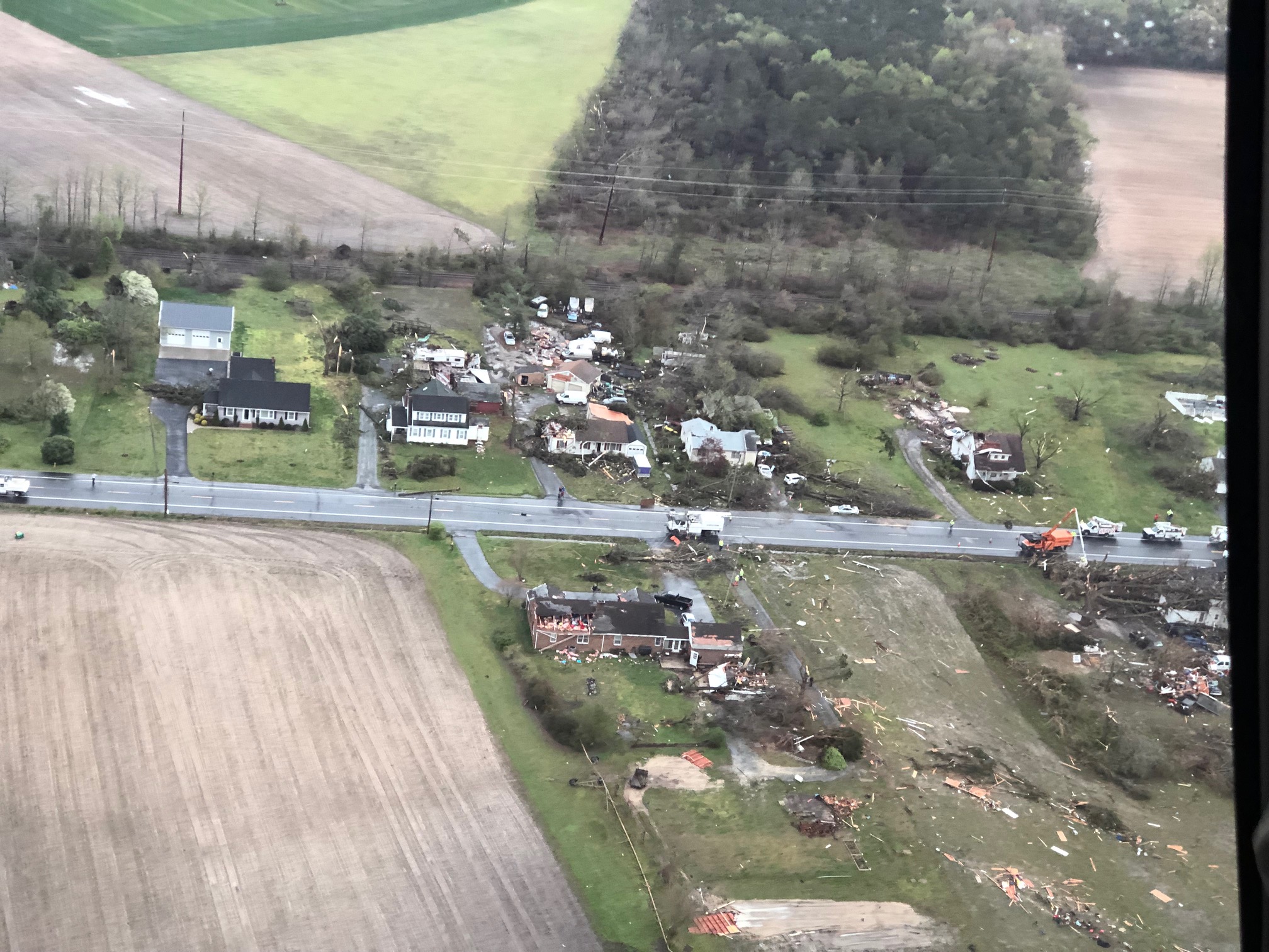 Tornado Damage in Laurel, DE (Image Courtesy Joseph Thomas) |
Synoptic Overview at 12z 14 April 2019 (courtesy of SPC)
 |
 |
 |
| Figure 1: 250-mb analysis | Figure 2: 300-mb analysis | Figure 3: 500-mb analysis |
 |
 |
 |
| Figure 4: 700-mb analysis | Figure 5: 850-mb analysis | Figure 6: 925-mb analysis |
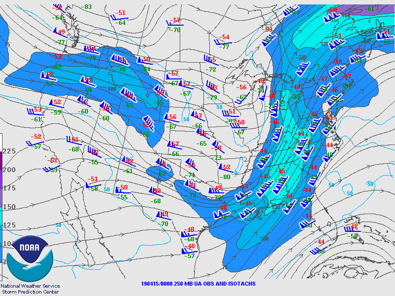
Synoptic Overview at 00z 15 April 2019 (courtesy of SPC)
 |
 |
 |
| Figure 7: 250-mb analysis | Figure 8: 300-mb analysis | Figure 9: 500-mb analysis |
 |
 |
 |
| Figure 10: 700-mb analysis | Figure 11: 850-mb analysis | Figure 12: 925-mb analysis |
Surface Maps (courtesy of WPC)
 |
 |
 |
| Figure 13: 18z surface map | Figure 14: 21z surface map | Figure 15: 00z surface map |
 |
 |
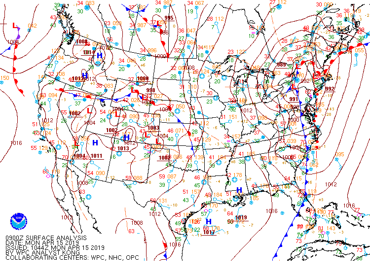 |
| Figure 16: 03z surface map | Figure 17: 06z surface map | Figure 18: 09z surface map |
 |
 |
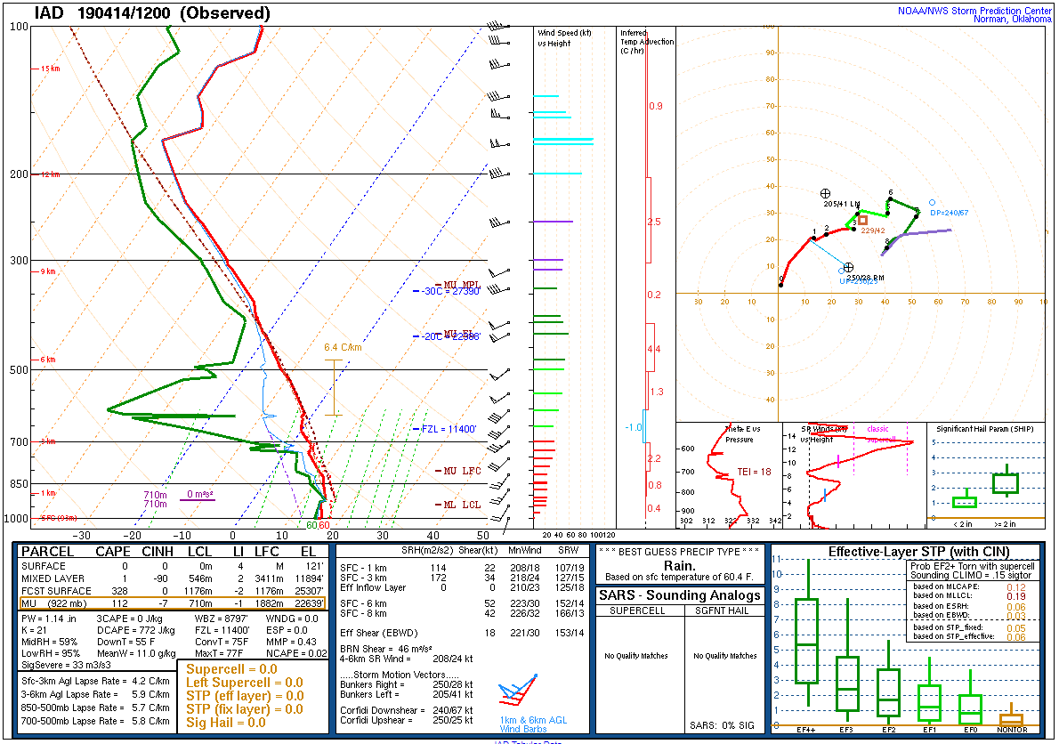 |
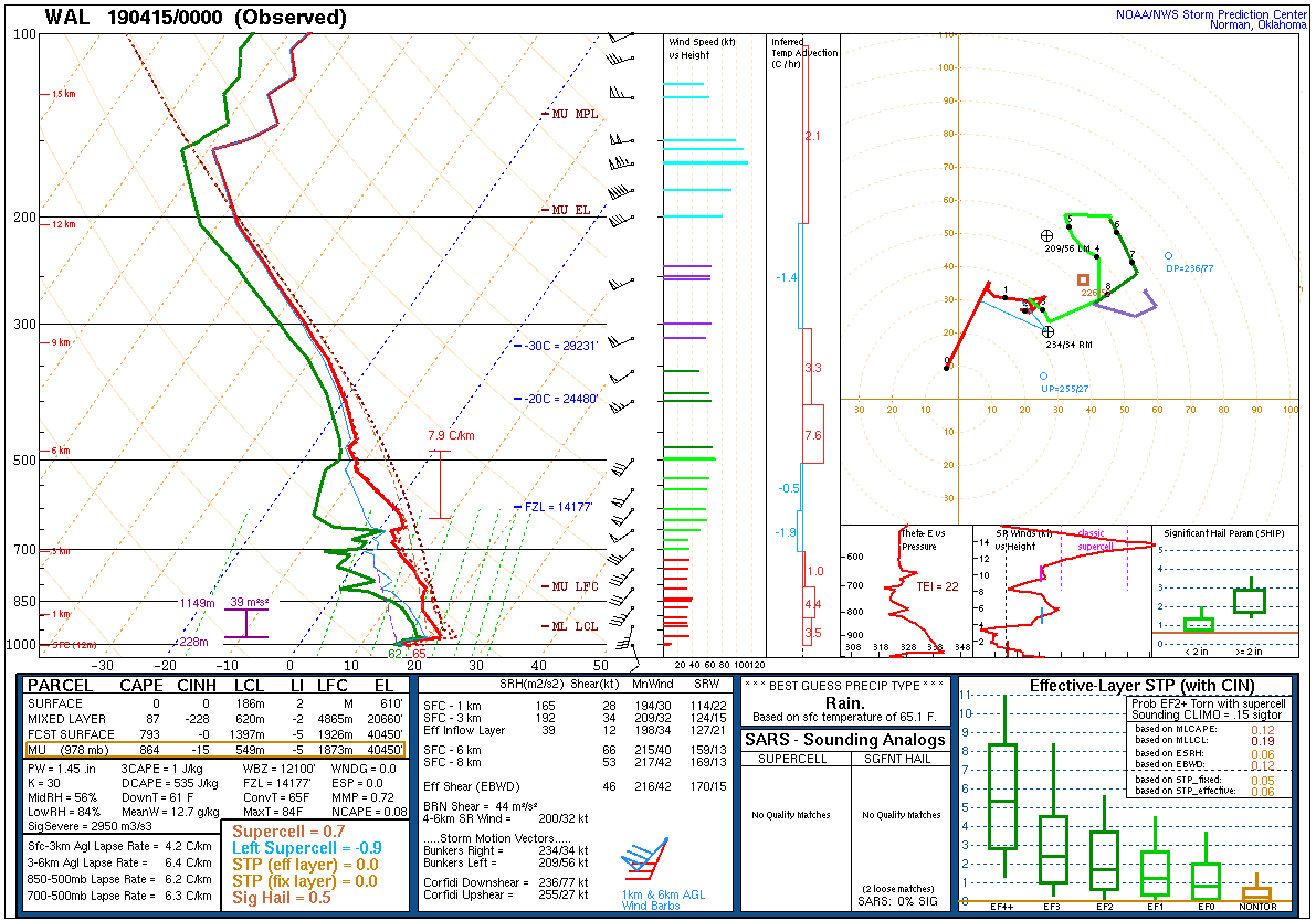
| Figure 19: 12z Wallops Island, VA sounding | Figure 20: 12z Pittsburgh, PA sounding | Figure 21: 12z Sterling, VA sounding |
 |
 |
 |
| Figure 22: 00z Wallops Island, VA sounding | Figure 23: 00z Pittsburgh, PA sounding | Figure 24: 00z Sterling, VA sounding |
 |
 |
 |
| Figure 1: National Preliminary Reports 12z 14 April 2019 to 12z 15 April 2019 | Figure 2: Zoomed Preliminary Reports -- Note the second Sussex County tornado is not in the preliminary reports. | Figure 3: Prelim Reports vs. 1630z SPC Convective Outlook |
Flash Flood Watch 0001
Areal Flood Advisory 0020
Tornado Watch 0074
Areal Flood Advisory 0021
Severe Thunderstorm Warning 0006
Areal Flood Advisory 0022
Severe Thunderstorm Warning 0007
Areal Flood Advisory 0023
Severe Thunderstorm Warning 0008
Tornado Warning 0001
Severe Thunderstorm Warning 0009
Special Marine Warning 0004
Areal Flood Advisory 0024
Severe Thunderstorm Warning 0010
Special Marine Warning 0005
Tornado Warning 0002
Wind Advisory 0007
Tornado Warning 0003
Severe Thunderstorm Warning 0011
Severe Thunderstorm Warning 0012
Tornado Warning 0004
Tornado Warning 0005
Severe Thunderstorm Warning 0013
Severe Thunderstorm Warning 0014
Special Marine Warning 0006
Severe Thunderstorm Warning 0015
Severe Thunderstorm Warning 0016
Areal Flood Advisory 0025
Special Marine Warning 0007
Special Marine Warning 0008
Special Marine Warning 0009
Areal Flood Warning 0004
NWUS51 KPHI 160838
LSRPHI

PRELIMINARY LOCAL STORM REPORT...SUMMARY
NATIONAL WEATHER SERVICE MOUNT HOLLY NJ
438 AM EDT TUE APR 16 2019

..TIME...   ...EVENT...      ...CITY LOCATION...     ...LAT.LON...
..DATE...   ....MAG....      ..COUNTY LOCATION..ST.. ...SOURCE....
            ..REMARKS..

0355 AM     TSTM WND GST     EASTAMPTON TWP          40.00N 74.75W
04/15/2019  E60 MPH          BURLINGTON         NJ   NWS EMPLOYEE


0348 AM     TSTM WND GST     BURLINGTON              40.07N 74.86W
04/15/2019  M59 MPH          BURLINGTON         NJ   MESONET


0340 AM     TSTM WND DMG     1 SSW HADDONFIELD       39.89N 75.03W
04/15/2019                   CAMDEN             NJ   PUBLIC

            HALF OF A TREE ROUGHLY 1-2 FEET IN DIAMETER
            FELL ON A CAR AND FENCE IN A RESIDENTIAL
            AREA. TIME ESTIMATED FROM RADAR.

0333 AM     TSTM WND DMG     1 SSE WHITMAN PARK      39.92N 75.11W
04/15/2019                   CAMDEN             NJ   BROADCAST MEDIA

            ROOF BLOWN OFF AN APARTMENT BUILDING AT S
            8TH STREET AND FERRY AVENUE. TIME ESTIMATED
            FROM RADAR.

0300 AM     TSTM WND DMG     1 SSW BOHEMIAS MILLS    39.45N 75.79W
04/15/2019                   CECIL              MD   911 CALL CENTER

            TREES REPORTED DOWN NEAR WARWICK. TIME
            ESTIMATED FROM RADAR.

0311 AM     TSTM WND GST     BROOKHAVEN              39.88N 75.39W
04/15/2019  M60 MPH          DELAWARE           PA   TRAINED SPOTTER


0356 AM     TSTM WND DMG     WILLIAMSTOWN            39.69N 75.00W
04/15/2019                   GLOUCESTER         NJ   TRAINED SPOTTER

            NUMEROUS TREES DOWN ACROSS THE TWP. TIME
            ESTIMATED FROM RADAR.

0325 AM     TSTM WND GST     LOGAN TWP.              39.80N 75.35W
04/15/2019  M64 MPH          GLOUCESTER         NJ   MESONET


0335 AM     TSTM WND DMG     1 WSW MCPHERSON         40.60N 74.88W
04/15/2019                   HUNTERDON          NJ   911 CALL CENTER

            TREES BLOWN DOWN IN CLINTON TOWNSHIP. TIME
            ESTIMATED FROM RADAR.

0312 AM     TSTM WND DMG     MARYDEL                 39.11N 75.74W
04/15/2019                   KENT               DE   911 CALL CENTER

            TREES BLOWN DOWN IN MARYDEL. TIME ESTIMATED
            FROM RADAR.

0305 AM     TSTM WND DMG     MILLINGTON              39.26N 75.84W
04/15/2019                   KENT               MD   911 CALL CENTER

            TREES AND WIRES DOWN IN MILLINGTON. TIME
            ESTIMATED FROM RADAR.

0536 AM     FLOOD            1 W BELMAR              40.18N 74.04W
04/15/2019                   ANZ450             NJ   PUBLIC

            FLOODING ON NJ 35 BOTH DIRECTIONS BETWEEN
            SOUTH OF NJ 71/H STREET (BELMAR) AND NORTH
            OF SHARK RIVER DRAWBRIDGE (NEPTUNE TWP) 1 TO
            2 LANES CLOSED.

0610 AM     FLOOD            2 SSE LAMBERTVILLE      40.34N 74.93W
04/15/2019                   MERCER             NJ   DEPT OF HIGHWAYS

            FLOODING ON NJ 29 BOTH DIRECTIONS AT VALLEY
            RD (HOPEWELL TWP) 1 LANE MAY BE CLOSED.

0407 AM     TSTM WND DMG     2 NNE WINDSOR           40.27N 74.57W
04/15/2019                   MERCER             NJ   NWS EMPLOYEE

            TREE FELL ONTO A HOUSE. TIME ESTIMATED FROM
            RADAR.

0403 AM     TSTM WND DMG     ROBBINSVILLE TWP.       40.23N 74.64W
04/15/2019                   MERCER             NJ   PUBLIC

            ROOF BLOWN OFF OF A SHED. SEVERAL TREES
            DOWN, INCLUDING ONE ONTO A VEHICLE. TIME
            ESTIMATED FROM RADAR.

0400 AM     TSTM WND DMG     2 W ROBBINSVILLE TWP.   40.23N 74.67W
04/15/2019                   MERCER             NJ   PUBLIC

            TREE DOWN. TIME ESTIMATED FROM RADAR.

0400 AM     TSTM WND DMG     2 SSE HAMILTON TWP      40.20N 74.71W
04/15/2019                   MERCER             NJ   DEPT OF HIGHWAYS

            DOWNED TREE ON I-295 SOUTHBOUND RAMP TO
            EXIT 61 - ARENA DR (HAMILTON TWP) RAMP CLOSED.
            TIME ESTIMATED FROM RADAR.

0400 AM     TSTM WND DMG     HAMILTON TWP            40.23N 74.72W
04/15/2019                   MERCER             NJ   PUBLIC

            MULTIPLE LARGE TREES DOWN.

0422 AM     TSTM WND DMG     1 E CHEESEQUAKE         40.42N 74.27W
04/15/2019                   MIDDLESEX          NJ   PUBLIC

            A ROW OF POWER POLES WERE SNAPPED ALONG
            ROUTE 34 IN OLD BRIDGE. TIME ESTIMATED FROM
            RADAR.

0404 AM     TSTM WND DMG     MIDDLESEX               40.58N 74.50W
04/15/2019                   MIDDLESEX          NJ   BROADCAST MEDIA

            TWO TREES UPROOTED IN MIDDLESEX.

0410 AM     TSTM WND DMG     3 NNE EAST WINDSOR TWP  40.31N 74.52W
04/15/2019                   MIDDLESEX          NJ   PUBLIC

            NUMEROUS TREES UPROOTED AND DOWNED IN CRANBURY TWP.
            TIME ESTIMATED FROM RADAR.

0601 AM     FLOOD            MANASQUAN               40.12N 74.05W
04/15/2019                   MONMOUTH           NJ   DEPT OF HIGHWAYS

            FLOODING ON NJ 71 BOTH DIRECTIONS SOUTH OF
            MAIN ST (MANASQUAN) 1 LANE MAY BE CLOSED.

0550 AM     TSTM WND DMG     1 ESE KEANSBURG         40.44N 74.12W
04/15/2019                   MONMOUTH           NJ   DEPT OF HIGHWAYS

            DOWNED TREE ON NJ 36 SOUTHBOUND THOMPSON AV
            (MIDDLETOWN TWP) RIGHT LANE CLOSED.

0536 AM     TSTM WND DMG     1 S STRATHMORE          40.39N 74.21W
04/15/2019                   MONMOUTH           NJ   DEPT OF HIGHWAYS

            DOWNED TREE ON NJ 34 SOUTHBOUND NORTH OF
            SCHANK RD (MARLBORO TWP) ALL LANES CLOSED.

0450 AM     TSTM WND GST     1 ENE MANASQUAN         40.13N 74.03W
04/15/2019  M62 MPH          MONMOUTH           NJ   MESONET

            SEA GIRT.

0442 AM     MARINE TSTM WIND SANDY HOOK              40.47N 74.01W
04/15/2019  M58 MPH          MONMOUTH           NJ   BUOY

            PEAK WIND GUST OF 70 MPH.

0439 AM     TSTM WND DMG     MIDDLETOWN TWP          40.40N 74.10W
04/15/2019                   MONMOUTH           NJ   BROADCAST MEDIA

            MEDIA REPORTS OF DOWNED TREES IN MIDDLETOWN.

0320 AM     TSTM WND DMG     PORT PENN               39.52N 75.58W
04/15/2019                   NEW CASTLE         DE   DEPT OF HIGHWAYS

            THE INTERSECTION OF W MARKET ST. AND DELAWARE CITY PORT
            PENN RD IS CLOSED DUE TO A UTILITY POLE AND TREE IN THE
            ROADWAY. TIME ESTIMATED FROM RADAR.

0320 AM     TSTM WND GST     PORT PENN               39.52N 75.58W
04/15/2019  M56 MPH          NEW CASTLE         DE   MESONET


0246 AM     TSTM WND DMG     3 NW GLASGOW            39.63N 75.78W
04/15/2019                   NEW CASTLE         DE   COCORAHS

            REPORT OF A TREE CAUSING A POWER OUTAGE AT A
            HOME ALONG THE MD-DE BORDER.

0542 AM     TSTM WND DMG     1 NNE LAKEHURST         40.03N 74.29W
04/15/2019                   OCEAN              NJ   DEPT OF HIGHWAYS

            DOWNED WIRES ON NJ 70 BOTH DIRECTIONS EAST
            OF NJ 37 (MANCHESTER TWP) ALL LANES CLOSED
            AND DETOURED 10-15 MINUTE DELAY USE CAUTION.

0440 AM     TSTM WND GST     BERKELEY TWP            39.93N 74.30W
04/15/2019  M62 MPH          OCEAN              NJ   MESONET


0439 AM     TSTM WND GST     4 ESE ROOSEVELT CITY    39.93N 74.29W
04/15/2019  M56 MPH          OCEAN              NJ   ASOS

            MILLER AIR PARK.

0341 AM     TSTM WND GST     NORTHEAST PHILADELPHIA  40.09N 75.02W
04/15/2019  M58 MPH          PHILADELPHIA       PA   ASOS


0330 AM     TSTM WND DMG     1 S CENTER CITY         39.97N 75.14W
04/15/2019                   PHILADELPHIA       PA   BROADCAST MEDIA

            A TREE WAS UPROOTED IN NORTHERN LIBERTIES.

0327 AM     TSTM WND GST     PHILADELPHIA INTERNATIO 39.88N 75.22W
04/15/2019  M64 MPH          PHILADELPHIA       PA   ASOS


0326 AM     TSTM WND DMG     1 SE POINT BREEZE       39.93N 75.17W
04/15/2019                   PHILADELPHIA       PA   BROADCAST MEDIA

            TREES UPROOTED, INCLUDING ONE ONTO A
            VEHICLE, AND A POWER POLE DOWN IN SOUTH
            PHILLY. TIME ESTIMATED FROM RADAR.

0320 AM     TSTM WND GST     1 SSW MANTUA            39.95N 75.20W
04/15/2019  E60 MPH          PHILADELPHIA       PA   PUBLIC


0520 AM     FLOOD            1 ESE BRIDGEWATER       40.59N 74.62W
04/15/2019                   SOMERSET           NJ   DEPT OF HIGHWAYS

            FLOODING ON US 22 WESTBOUND AREA OF CR
            643/MOUNTAIN AVE (BRIDGEWATER TWP) LEFT LANE
            CLOSED.

0435 AM     TSTM WND GST     5 E LONG NECK           38.62N 75.07W
04/15/2019  M58 MPH          SUSSEX             DE   MESONET

            INDIAN RIVER INLET.

0429 AM     TSTM WND GST     DEWEY BEACH             38.69N 75.07W
04/15/2019  M54 MPH          SUSSEX             DE   MESONET


0406 AM     TSTM WND GST     5 NW LEWES              38.82N 75.20W
04/15/2019  M69 MPH          SUSSEX             DE   PUBLIC

            WIND GUST MEASURED WITH ANEMOMETER. ROOF
            DAMAGE TO A BUILDING IN BROADKILL BEACH.
            TIME ESTIMATED FROM RADAR.

0359 AM     TSTM WND DMG     2 N HARBESON            38.74N 75.28W
04/15/2019                   SUSSEX             DE   BROADCAST MEDIA

            ROOF DAMAGE TO A MOBILE HOME AND SHED. TIME
            ESTIMATED FROM RADAR.

0345 AM     TSTM WND DMG     3 NNE SEAFORD           38.69N 75.59W
04/15/2019                   SUSSEX             DE   DEPT OF HIGHWAYS

            US 13 NB & SB BETWEEN CAMP RD AND BOYCE RD IS CLOSED
            DUE TO WIRES DOWN. TIME ESTIMATED FROM RADAR.

0340 AM     TSTM WND GST     SEAFORD                 38.64N 75.61W
04/15/2019  M50 MPH          SUSSEX             DE   MESONET


0340 AM     TSTM WND GST     LAUREL                  38.56N 75.57W
04/15/2019  M55 MPH          SUSSEX             DE   MESONET


0338 AM     TORNADO          1 E BETHEL              38.57N 75.59W
04/15/2019                   SUSSEX             DE   NWS STORM SURVEY

            *** 1 INJ ***
            EF2 TORNADO CONFIRMED WITH ESTIMATED MAXIMUM
            WINDS OF 120 MPH. A TORNADO CAUSED DAMAGE
            ALONG A PATH FROM LAUREL TO SEAFORD
            DELAWARE. A TREE FELL ON A HOUSE, CAUSING
            ONE INJURY. ONE BARN WAS DESTROYED. THERE
            WAS ROOF DAMAGE TO SEVERAL OTHER HOMES AND
            BARNS. MANY TREES WERE UPROOTED ALONG THE
            PATH AND A FEW WERE SNAPPED.

0313 AM     TSTM WND DMG     STILLWATER TWP          41.06N 74.86W
04/15/2019                   SUSSEX             NJ   PUBLIC

            TREES AND POWER LINES DOWN IN STILLWATER
            TWP. TIME ESTIMATED FROM RADAR.


&&

$$
NOUS41 KPHI 182300
PNSPHI
DEZ001>004-191100-

Public Information Statement
National Weather Service Mount Holly NJ
700 PM EDT Thu Apr 18 2019

...NWS DAMAGE SURVEYS FOR 04/15/19 TORNADO EVENT...

.Milton Delaware Tornado...

Start Location...Harbeson in Sussex County Delaware
End Location...Broadkill Beach in Sussex County Delaware
Date...April 15, 2019
Estimated Time...4:00 AM EDT to 4:07 AM EDT
Maximum EF-Scale Rating...EF1
Estimated Maximum Wind Speed...100 mph
Maximum Path Width...50 yards
Path Length...6.2 miles
Beginning Lat/Lon...38.7400/-75.2788
Ending Lat/Lon...38.8147/-75.1978
* Fatalities...0
* Injuries...0

...Summary...
A tornado touched down near Carpenter Road in Harbeson. This tornado
was associated with the same parent circulation that produced an EF2
tornado in Laurel, DE. Sporadic damage occurred over the remainder
of the path, and the tornado may not have been on the ground
continuously. Damage was observed on Shay Lane, where a few trees
were snapped and a section of a barn roof was removed. Near the
coast on South Bay Shore Drive, a couple of additional trees were
snapped along with some roof damage. A distinct swirling pattern was
also seen in a marsh grassy area at this location. Beyond this
point the circulation moved offshore. Dual polarization radar data
was also useful in confirming a tornado debris signature.

.Updated information on Laurel Delaware Tornado...

Start Location...Laurel in Sussex County Delaware
End Location...Georgetown in Sussex County Delaware
Date...April 15, 2019
Estimated Time...3:38 AM EDT to 3:49 AM EDT
Maximum EF-Scale Rating...EF2
Estimated Maximum Wind Speed...120 mph
Maximum Path Width...50 to 400 yards
Path Length...9.3 miles
Beginning Lat/Lon...38.5729/-75.5929
Ending Lat/Lon...38.6502/-75.4554
* Fatalities...0
* Injuries...1

...Summary...
A tornado traveled from Woodland Ferry Road northeast to Asbury
Road. Numerous homes along the path sustained considerable damage
to exterior walls and roofs. One home's roof was nearly completely
blown off. One barn was destroyed. The tornado reached its maximum
width of about 400 yard as it crossed Seaford Road in Laurel,
where a few wooden power poles were snapped. One large wooden
power pole was broken at the base. A tree fell on a house,
resulting in one injury. Additionally, there was considerable roof
and structural damage to several other barns and farm out-
buildings. Many trees were uprooted along the tornado path, and a
few were snapped. The damage became sporadic and somewhat
discontinuous for the approximately the last 3 miles of the track.
The tornado lifted as it crossed Asbury Road, where it rolled a
mobile home onto its side. The National Weather Service would like
to extend our thanks to Sussex County Emergency Management for
their assistance in this damage survey.

EF Scale: The Enhanced Fujita Scale classifies tornadoes into the
following categories:

EF0...Weak......65 to 85 mph
EF1...Weak......86 to 110 mph
EF2...Strong....111 to 135 mph
EF3...Strong....136 to 165 mph
EF4...Violent...166 to 200 mph
EF5...Violent...>200 mph

* The information in this statement is preliminary and subject to
change pending final review of the event and publication in NWS
Storm Data.

$$

Milton Tornado...O'Brien/Staarmann
Laurel Tornado...Davis/SFJ/Staarmann
Sussex (DE) County Tornadoes (GR2Analyst)
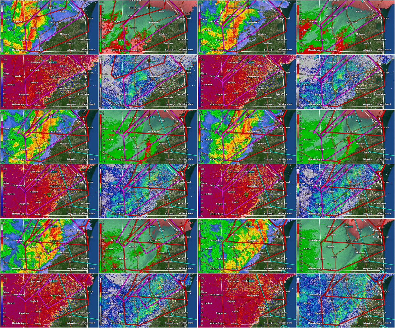 |
 |
| Figure 1: Animated KDOX radar imagery of the Seaford, DE, tornado on 15 April 2019. Base reflectivity (top left), storm-relative motion (top right), correlation coefficient (bottom left) and differential reflectivity (bottom right) from 0734 to 0758 UTC. Note the very low correlation coefficient values collocated with strong rotation and an embedded hook signature in radar reflectivity -- a clear indication of a tornadic debris signature | Figure 2: Same as Fig. 1, valid at 0756 to 0809 UTC 15 April 2019. This signature is more subtle, but there is rapidly converging rotation and a subtle lowering of correlation coefficient where the tornado was confirmed from a storm survey. |