
A heat wave over the Southwest will intensify this week, peaking and expanding into the Intermountain West and northern High Plains this weekend. Critical to extremely critical fire weather conditions are forecast from the Northwest and the northern Great Basin this weekend. Particularly Dangerous Situation Red Flag Warnings have been issued. Read More >
Overview
|
A relatively localized snow event occurred on 5 December 2018, primarily in southern New Jersey. A surface trough extending northwestward from a surface low in the western Atlantic generated sufficient lift to produce snow during the day, aided by a midlevel shortwave trough approaching the region. The snow became heavy as favorable low-level frontogenetical lift developed during the late morning and afternoon hours. Mesoscale banding developed and remained fairly stationary for a few hours near Atlantic City and Ocean City, diminishing in intensity as the band penetrated inland to southern portions of the Philadelphia metro area. The heaviest snow fell in Brigantine, where 6-8 inches fell in a few hours. As the low progressed farther offshore late in the afternoon, the trough shifted offshore as well, with snow dissipating by early evening.
|
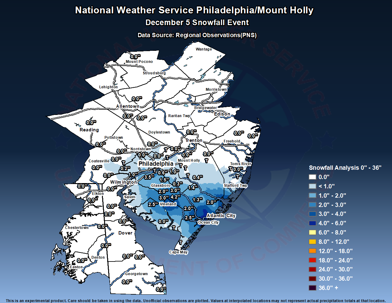 Storm Total Snowfall for the Event |
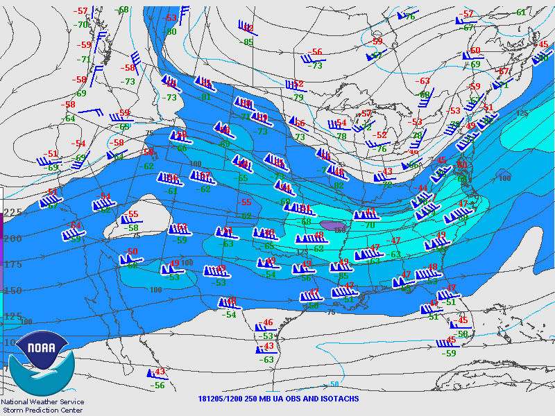
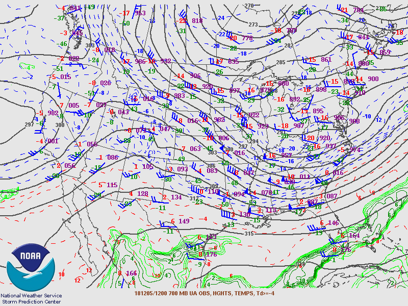
Synoptic Overview at 00z 5 Dec 2018 (courtesy of SPC)
 |
 |
 |
| Figure 1: 250-mb analysis | Figure 2: 300-mb analysis | Figure 3: 500-mb analysis |
 |
 |
 |
| Figure 4: 700-mb analysis | Figure 5: 850-mb analysis | Figure 6: 925-mb analysis |
Synoptic Overview at 12z 5 Dec 2018 (courtesy of SPC)
 |
 |
 |
| Figure 7: 250-mb analysis | Figure 8: 300-mb analysis | Figure 9: 500-mb analysis |
 |
 |
 |
| Figure 10: 700-mb analysis | Figure 11: 850-mb analysis | Figure 12: 925-mb analysis |
Surface Maps (courtesy of SPC)
 |
 |
 |
| Figure 13: 00z 5 Dec 2018 surface map | Figure 14: 12z 5 Dec 2018 surface map | Figure 15: 00z 6 Dec 2018 surface map |
Winter Weather Advisory 0021
Winter Storm Warning 0009
NOUS41 KPHI 061748
PNSPHI
DEZ001>004-MDZ008-012-015-019-020-NJZ001-007>010-012>027-PAZ054-055-060>062-
070-071-101>106-070548-

Public Information Statement
National Weather Service Mount Holly NJ
1248 PM EST Thu Dec 6 2018

...SNOWFALL REPORTS...

Location                     Amount    Time/Date       Lat/Lon

...New Jersey...

...Atlantic County...
Brigantine                   7.5 in    0340 PM 12/05   39.40N/74.37W
1 N Brigantine               7.3 in    0732 PM 12/05   39.42N/74.37W
2 NE Atlantic City           6.4 in    0432 AM 12/06   39.39N/74.40W
3 SE Egg Harbor Twp          6.0 in    0832 AM 12/06   39.36N/74.58W
1 NE Egg Harbor Twp          5.5 in    0427 PM 12/05   39.40N/74.62W
Somers Point                 4.5 in    0439 PM 12/05   39.31N/74.60W
Pleasantville                4.4 in    0656 PM 12/05   39.39N/74.52W
Estell Manor 5.2 NE          4.1 in    0700 AM 12/06   39.41N/74.71W
3 WSW Pleasantville          3.8 in    0515 PM 12/05   39.38N/74.57W
1 W Egg Harbor Twp           3.0 in    0113 PM 12/05   39.39N/74.64W
Egg Harbor Twp               3.0 in    0126 PM 12/05   39.39N/74.64W
Pleasantville                3.0 in    0259 PM 12/05   39.39N/74.52W
Smithville                   3.0 in    0803 PM 12/05   39.49N/74.46W
Atlantic City                2.8 in    0115 PM 12/05   39.37N/74.42W
Corbin City                  2.8 in    0330 PM 12/05   39.30N/74.75W
Absecon                      2.2 in    0100 PM 12/05   39.43N/74.51W
Galloway Twp                 2.0 in    1230 PM 12/05   39.47N/74.51W
Mays Landing                 2.0 in    1242 PM 12/05   39.45N/74.73W
Pleasantville                1.5 in    0123 PM 12/05   39.39N/74.52W
Galloway Twp                 1.5 in    0150 PM 12/05   39.47N/74.51W
Hammonton                    1.4 in    0100 PM 12/05   39.63N/74.80W
Egg Harbor City              1.3 in    1245 PM 12/05   39.53N/74.65W

...Burlington County...
Tabernacle                   0.5 in    0130 PM 12/05   39.84N/74.71W
Tabernacle Twp. 5 WNW        0.4 in    0745 AM 12/06   39.84N/74.75W
Cinnaminson Twp.             0.2 in    0700 AM 12/06   40.00N/74.98W
1 ENE Westampton Twp          T in     0100 PM 12/05   40.01N/74.82W
Medford Lakes                 T in     0700 AM 12/06   39.86N/74.82W
Mount Laurel                  T in     0700 AM 12/06   39.97N/74.86W

...Camden County...
Lindenwold                   1.0 in    0244 PM 12/05   39.82N/74.97W
1 SSW Magnolia               0.6 in    0400 PM 12/05   39.84N/75.04W
2 NNE West Berlin             T in     0120 PM 12/05   39.84N/74.92W

...Cape May County...
1 WNW Marmora                5.0 in    0423 PM 12/05   39.27N/74.67W
Beesleys Point               5.0 in    0424 PM 12/05   39.28N/74.64W
Ocean City                   4.5 in    0418 PM 12/05   39.28N/74.57W
Seaville                     3.0 in    0435 PM 12/05   39.22N/74.70W
Ocean City                   2.5 in    0420 PM 12/05   39.28N/74.57W
Petersburg                   2.5 in    0420 PM 12/05   39.25N/74.73W
Tuckahoe                     2.5 in    0433 PM 12/05   39.29N/74.76W
Ocean View                   2.0 in    0219 PM 12/05   39.21N/74.70W
Belleplain                   2.0 in    0438 PM 12/05   39.27N/74.86W
Woodbine 0.8 NNW             1.4 in    0700 AM 12/06   39.24N/74.82W
2 E Delmont                  0.5 in    0226 PM 12/05   39.21N/74.92W
Wildwood Crest                T in     0731 AM 12/06   38.97N/74.84W

...Cumberland County...
Vineland                     4.8 in    0235 PM 12/05   39.49N/75.03W
Vineland                     2.0 in    0155 PM 12/05   39.49N/75.03W

...Gloucester County...
Newfield                     4.2 in    0440 PM 12/05   39.55N/75.02W
West Deptford Twp            3.5 in    0502 PM 12/05   39.84N/75.20W
Newfield                     3.0 in    0114 PM 12/05   39.55N/75.02W
Williamstown                 3.0 in    0507 PM 12/05   39.69N/75.00W
Mantua                       2.0 in    0230 PM 12/05   39.79N/75.17W
Mullica Hill                 2.0 in    0324 PM 12/05   39.74N/75.22W
Franklin Twp                 2.0 in    0547 PM 12/05   39.59N/75.06W
1 WNW Turnersville           1.5 in    0700 AM 12/06   39.77N/75.09W
4 WSW Turnersville           1.2 in    0700 AM 12/06   39.73N/75.13W
Williamstown                 0.3 in    1222 PM 12/05   39.69N/74.99W

...Ocean County...
1 ESE Barnegat Twp            T in     0121 PM 12/05   39.76N/74.25W
Lacey Twp. 6 E                T in     0530 AM 12/06   39.86N/74.14W
Point Pleasant Beach          T in     0700 AM 12/06   40.09N/74.05W
Stafford Twp. 2.8 NNW         T in     0700 AM 12/06   39.74N/74.29W
Stafford Twp. 2.1 NW          T in     0800 AM 12/06   39.73N/74.29W

...Salem County...
2 N Rosenhayn                2.5 in    0500 AM 12/06   39.51N/75.14W

...Pennsylvania...

...Chester County...
West Chester 2.4 SSE         0.2 in    0700 AM 12/06   39.93N/75.60W
West Chester 2 SE             T in     0700 AM 12/06   39.94N/75.58W
West Chester                 0.0 in    0708 AM 12/06   39.96N/75.60W

...Delaware County...
Aston Twp.                   1.0 in    0558 PM 12/05   39.87N/75.43W
Chadds Ford Twp              0.3 in    0512 PM 12/05   39.87N/75.59W

...Philadelphia County...
Philadelphia International A 0.3 in    0700 PM 12/05   39.88N/75.22W
Rockledge SE                  T in     0700 AM 12/05   40.07N/75.07W
Philadelphia International A  T in     0100 PM 12/05   39.88N/75.22W
Philadelphia 4.7 NE           T in     0630 AM 12/06   40.06N/75.08W
Rockledge SE                  T in     0700 AM 12/06   40.07N/75.07W
&&

**METADATA**
:12/05/2018,1245 PM,NJ,Atlantic,Egg Harbor City,,,39.528959530231,-74.647390543519,SNOW,1.25,INCH,Trained Spotter,
:12/05/2018,1300 PM,NJ,Atlantic,Hammonton,,,39.634611833466,-74.803838430937,SNOW_24,1.4,INCH,Trained Spotter,
:12/05/2018,1323 PM,NJ,Atlantic,Pleasantville,,,39.3908,-74.5213,SNOW_24,1.5,INCH,Broadcast Media,
:12/05/2018,1350 PM,NJ,Atlantic,Galloway Twp,,,39.468,-74.507,SNOW_24,1.5,INCH,Trained Spotter,
:12/05/2018,1230 PM,NJ,Atlantic,Galloway Twp,,,39.4702,-74.5103,SNOW_24,2.0,INCH,Broadcast Media,
:12/05/2018,1242 PM,NJ,Atlantic,Mays Landing,,,39.452106801135,-74.727534948876,SNOW,2.0,INCH,Broadcast Media,
:12/05/2018,1300 PM,NJ,Atlantic,Absecon,,,39.432204984436,-74.506349264678,SNOW_24,2.2,INCH,Trained Spotter,
:12/05/2018,1315 PM,NJ,Atlantic,Atlantic City,,,39.37156219956,-74.421376883085,SNOW_24,2.8,INCH,ASOS,
:12/05/2018,1530 PM,NJ,Atlantic,Corbin City,,,39.300579236953,-74.753144680557,SNOW,2.8,INCH,Trained Spotter,
:12/05/2018,1313 PM,NJ,Atlantic,1 W Egg Harbor Twp,,,39.3898,-74.6423,SNOW_24,3.0,INCH,Public,
:12/05/2018,1326 PM,NJ,Atlantic,Egg Harbor Twp,,,39.3902,-74.6386,SNOW_24,3.0,INCH,Public,
:12/05/2018,1459 PM,NJ,Atlantic,Pleasantville,,,39.3906,-74.5239,SNOW_24,3.0,INCH,Broadcast Media,
:12/05/2018,2003 PM,NJ,Atlantic,Smithville,,,39.4934,-74.4581,SNOW_24,3.0,INCH,Broadcast Media,
:12/05/2018,1715 PM,NJ,Atlantic,3 WSW Pleasantville,,,39.37611111,-74.57027778,SNOW_24,3.8,INCH,Trained Spotter,
:12/06/2018,0700 AM,NJ,Atlantic,Estell Manor 5.2 NE,,,39.414031,-74.708725,SNOW_24,4.1,INCH,COCORAHS,
:12/05/2018,1856 PM,NJ,Atlantic,Pleasantville,,,39.394009395062,-74.519567190703,SNOW,4.4,INCH,Broadcast Media,
:12/05/2018,1639 PM,NJ,Atlantic,Somers Point,,,39.3128,-74.5965,SNOW_24,4.5,INCH,Trained Spotter,
:12/05/2018,1627 PM,NJ,Atlantic,1 NE Egg Harbor Twp,,,39.3981,-74.6207,SNOW_24,5.5,INCH,Public,
:12/06/2018,0832 AM,NJ,Atlantic,3 SE Egg Harbor Twp,,,39.3626,-74.5811,SNOW_24,6.0,INCH,Public,
:12/06/2018,0432 AM,NJ,Atlantic,2 NE Atlantic City,,,39.3901,-74.4019,SNOW_24,6.4,INCH,Public,
:12/05/2018,1932 PM,NJ,Atlantic,1 N Brigantine,,,39.4167,-74.3701,SNOW_24,7.3,INCH,Public,
:12/05/2018,1540 PM,NJ,Atlantic,Brigantine,,,39.401927083557,-74.372313915788,SNOW,7.5,INCH,Public,
:12/05/2018,1300 PM,NJ,Burlington,1 ENE Westampton Twp,,,40.013453504304,-74.817305802403,SNOW_24,0.001,INCH,Official NWS Obs,
:12/06/2018,0700 AM,NJ,Burlington,Medford Lakes,,,39.8572,-74.8169999,SNOW_24,0.001,INCH,COCORAHS,
:12/06/2018,0700 AM,NJ,Burlington,Mount Laurel,,,39.968377,-74.864779,SNOW_24,0.001,INCH,COCORAHS,
:12/06/2018,0700 AM,NJ,Burlington,Cinnaminson Twp.,,,39.998581,-74.980484,SNOW_24,0.2,INCH,COCORAHS,
:12/06/2018,0745 AM,NJ,Burlington,Tabernacle Twp. 5 WNW,,,39.8378,-74.7467,SNOW_24,0.4,INCH,COCORAHS,
:12/05/2018,1330 PM,NJ,Burlington,Tabernacle,,,39.843,-74.71,SNOW,0.5,INCH,Trained Spotter,
:12/05/2018,1320 PM,NJ,Camden,2 NNE West Berlin,,,39.8441,-74.9247,SNOW_24,0.001,INCH,Public,
:12/05/2018,1600 PM,NJ,Camden,1 SSW Magnolia,,,39.8372,-75.0442,SNOW_24,0.6,INCH,CO-OP Observer,
:12/05/2018,1444 PM,NJ,Camden,Lindenwold,,,39.816915192545,-74.970264135888,SNOW,1.0,INCH,Trained Spotter,
:12/06/2018,0731 AM,NJ,Cape May,Wildwood Crest,,,38.9716809,-74.83976,SNOW_24,0.001,INCH,COCORAHS,
:12/05/2018,1426 PM,NJ,Cape May,2 E Delmont,,,39.2149,-74.9219,SNOW_24,0.5,INCH,Trained Spotter,
:12/06/2018,0700 AM,NJ,Cape May,Woodbine 0.8 NNW,,,39.237795,-74.817278,SNOW_24,1.4,INCH,COCORAHS,
:12/05/2018,1419 PM,NJ,Cape May,Ocean View,,,39.2091,-74.7034,SNOW_24,2.0,INCH,Trained Spotter,
:12/05/2018,1638 PM,NJ,Cape May,Belleplain,,,39.2714,-74.8634,SNOW_24,2.0,INCH,Trained Spotter,
:12/05/2018,1620 PM,NJ,Cape May,Ocean City,,,39.27879051735,-74.573501049576,SNOW,2.5,INCH,Trained Spotter,
:12/05/2018,1620 PM,NJ,Cape May,Petersburg,,,39.254577493784,-74.726676641999,SNOW_24,2.5,INCH,Trained Spotter,
:12/05/2018,1633 PM,NJ,Cape May,Tuckahoe,,,39.2907,-74.7576,SNOW_24,2.5,INCH,Trained Spotter,
:12/05/2018,1635 PM,NJ,Cape May,Seaville,,,39.2164,-74.6953,SNOW_24,3.0,INCH,Trained Spotter,
:12/05/2018,1618 PM,NJ,Cape May,Ocean City,,,39.27879051735,-74.573501049576,SNOW_24,4.5,INCH,Trained Spotter,
:12/05/2018,1623 PM,NJ,Cape May,1 WNW Marmora,,,39.2735,-74.6665,SNOW_24,5.0,INCH,Trained Spotter,
:12/05/2018,1624 PM,NJ,Cape May,Beesleys Point,,,39.2772,-74.6356,SNOW_24,5.0,INCH,Trained Spotter,
:12/05/2018,1355 PM,NJ,Cumberland,Vineland,,,39.486834352852,-75.02565711647,SNOW,2.0,INCH,Public,
:12/05/2018,1435 PM,NJ,Cumberland,Vineland,,,39.486834352852,-75.02565711647,SNOW,4.8,INCH,Public,
:12/05/2018,1222 PM,NJ,Gloucester,Williamstown,,,39.6916,-74.9927,SNOW_24,0.25,INCH,Public,
:12/06/2018,0700 AM,NJ,Gloucester,4 WSW Turnersville,,,39.733175,-75.133069,SNOW_24,1.2,INCH,COCORAHS,
:12/06/2018,0700 AM,NJ,Gloucester,1 WNW Turnersville,,,39.773862,-75.092523,SNOW_24,1.5,INCH,COCORAHS,
:12/05/2018,1430 PM,NJ,Gloucester,Mantua,,,39.792,-75.169,SNOW_24,2.0,INCH,Public,
:12/05/2018,1524 PM,NJ,Gloucester,Mullica Hill,,,39.740200399883,-75.221383272707,SNOW,2.0,INCH,Trained Spotter,
:12/05/2018,1747 PM,NJ,Gloucester,Franklin Twp,,,39.592492115842,-75.060826241072,SNOW_24,2.0,INCH,Trained Spotter,
:12/05/2018,1314 PM,NJ,Gloucester,Newfield,,,39.5498,-75.0203,SNOW_24,3.0,INCH,Trained Spotter,
:12/05/2018,1707 PM,NJ,Gloucester,Williamstown,,,39.6875,-75.0029,SNOW_24,3.0,INCH,Public,
:12/05/2018,1702 PM,NJ,Gloucester,West Deptford Twp,,,39.8414,-75.1984,SNOW_24,3.5,INCH,Trained Spotter,
:12/05/2018,1640 PM,NJ,Gloucester,Newfield,,,39.5485,-75.0202,SNOW_24,4.2,INCH,Trained Spotter,
:12/05/2018,1321 PM,NJ,Ocean,1 ESE Barnegat Twp,,,39.7597,-74.2485,SNOW_24,0.001,INCH,Public,
:12/06/2018,0530 AM,NJ,Ocean,Lacey Twp. 6 E,,,39.8626,-74.141,SNOW_24,0.001,INCH,COCORAHS,
:12/06/2018,0700 AM,NJ,Ocean,Point Pleasant Beach,,,40.087813,-74.05201,SNOW_24,0.001,INCH,COCORAHS,
:12/06/2018,0700 AM,NJ,Ocean,Stafford Twp. 2.8 NNW,,,39.7412112,-74.2906811,SNOW_24,0.001,INCH,COCORAHS,
:12/06/2018,0800 AM,NJ,Ocean,Stafford Twp. 2.1 NW,,,39.728719,-74.289391,SNOW_24,0.001,INCH,COCORAHS,
:12/06/2018,0500 AM,NJ,Salem,2 N Rosenhayn,,,39.513747,-75.136298,SNOW_24,2.5,INCH,COCORAHS,
:12/06/2018,0708 AM,PA,Chester,West Chester,,,39.963674385733,-75.597498714023,SNOW,0.0,INCH,Public,
:12/06/2018,0700 AM,PA,Chester,West Chester 2 SE,,,39.941070556641,-75.581871032715,SNOW_24,0.001,INCH,COCORAHS,
:12/06/2018,0700 AM,PA,Chester,West Chester 2.4 SSE,,,39.925851,-75.595228,SNOW_24,0.2,INCH,COCORAHS,
:12/05/2018,1712 PM,PA,Delaware,Chadds Ford Twp,,,39.8722,-75.5918,SNOW_24,0.3,INCH,Trained Spotter,
:12/05/2018,1758 PM,PA,Delaware,Aston Twp.,,,39.867725402935,-75.426132380067,SNOW,1.0,INCH,Public,
:12/05/2018,0700 AM,PA,Philadelphia,Rockledge SE,,,40.06771,-75.074773,SNOW_24,0.001,INCH,COCORAHS,
:12/05/2018,1300 PM,PA,Philadelphia,Philadelphia International Airport,,,39.8768,-75.225,SNOW_24,0.001,INCH,ASOS,
:12/06/2018,0630 AM,PA,Philadelphia,Philadelphia 4.7 NE,,,40.058599,-75.07703,SNOW_24,0.001,INCH,COCORAHS,
:12/06/2018,0700 AM,PA,Philadelphia,Rockledge SE,,,40.06771,-75.074773,SNOW_24,0.001,INCH,COCORAHS,
:12/05/2018,1900 PM,PA,Philadelphia,Philadelphia International Airport,,,39.8768,-75.225,SNOW,0.3,INCH,ASOS,

Observations are collected from a variety of sources with varying
equipment and exposures. We thank all volunteer weather observers
for their dedication. Not all data listed are considered official.

$$
Mesoscale Snow Band
 |
| Figure 1: Loop of radar reflectivity factor from DIX valid 1200-2359 UTC 5 December 2018. Snow rapidly develops inland and intensifies during the morning hours before peaking in intensity and westward extent during the early afternoon. The precipitation then pivots and slowly dissipates as it progresses offshore by early evening. Note the steady moderate to heavy snow that develops near the coast with little movement of this higher-intensity precipitation for several hours. Localized snow totals over half a foot occurred in this area. |


 Coastal Flood
 Marine Forecasts
 Text Products
 Climate Information
 Skywarn
 Submit Storm Report
 Weather Event Archives
 Forecast Discussion
 Emergency Managers
 Briefing Page