
A significant heat wave continues for the Rockies, Northern Plains, and Great Lakes into the Mid-Atlantic, peaking in intensity through midweek and lingering across parts of the Northern Plains and Midwest until this weekend. Excessive rainfall my bring life-threatening and locally catastrophic flash and urban flooding across portions of southwestern Texas through early Friday. Read More >
Overview
|
Scattered thunderstorms developed along and south of a warm front in northern Pennsylvania and southern New York during the afternoon, including a few supercells. Some of the storms produced tornadoes and damaging straight-line winds before moving into portions of the Poconos and far northwest New Jersey during the late afternoon and early evening hours. One of these supercells produced two tornadoes (one each in Carbon and Monroe Counties) before moving into northern New Jersey. Meanwhile, storms to the west of this supercell congealed into a line and began to train over portions of eastern Pennsylvania and northern New Jersey during the mid-evening hours. Several reports of flooding were received from Monroe, Sussex, Warren, and Morris Counties during this phase of the event. As the storms matured into a mesoscale convective system (MCS), a strong cold pool developed and allowed the line of storms to propagate into southeast Pennsylvania and central New Jersey, where a couple of wind-damage reports occurred, before moving offshore after midnight.
|
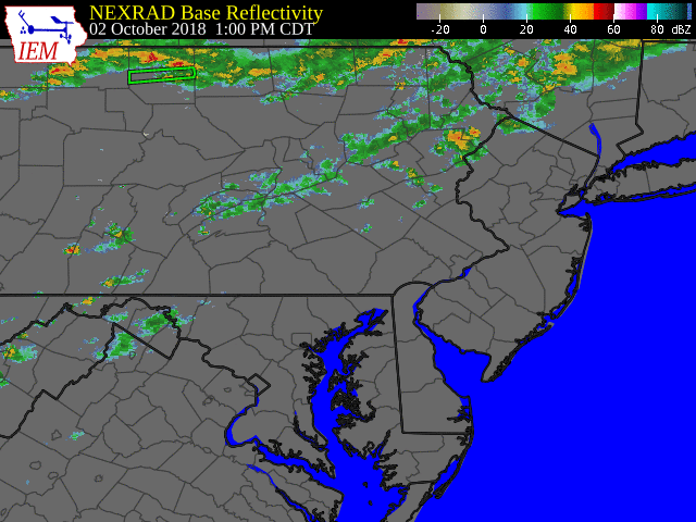 Radar Reflectivity Animation for the Event |
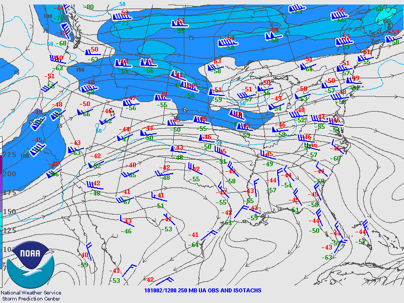
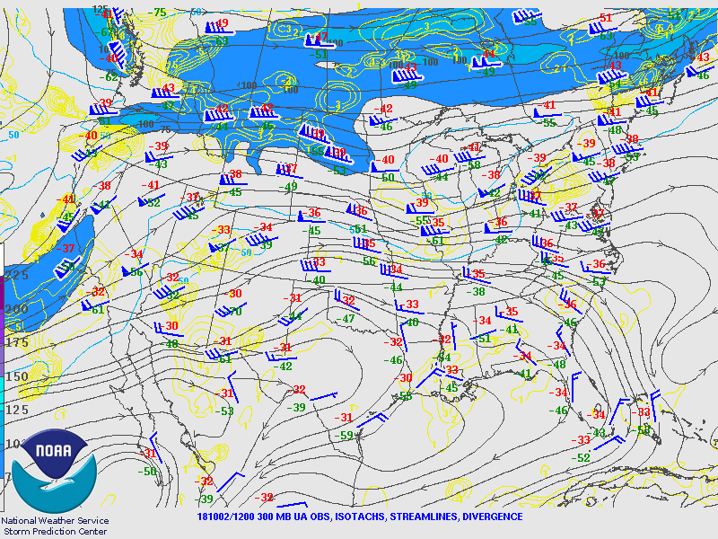
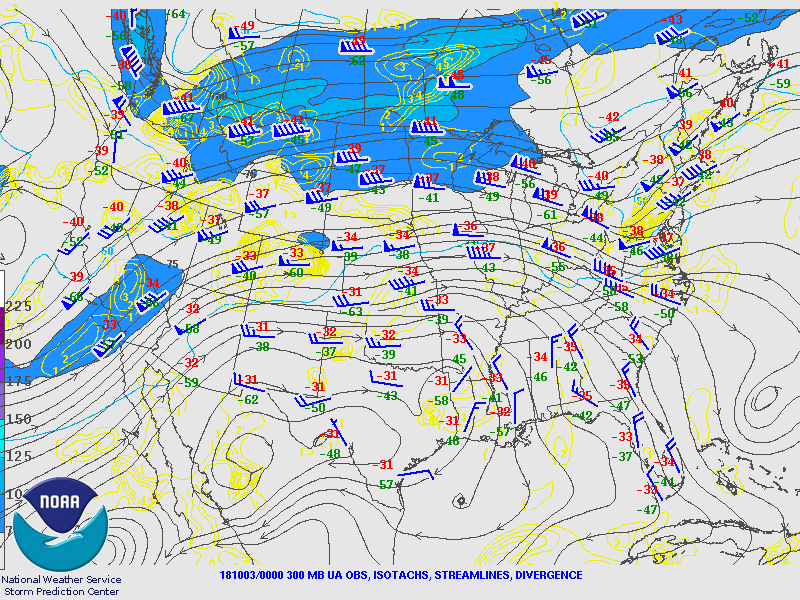
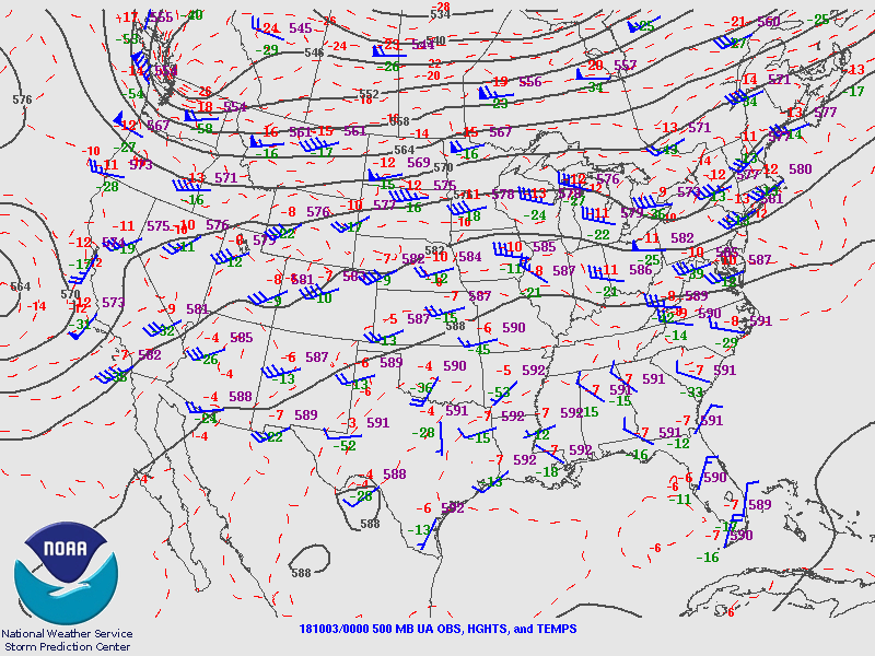
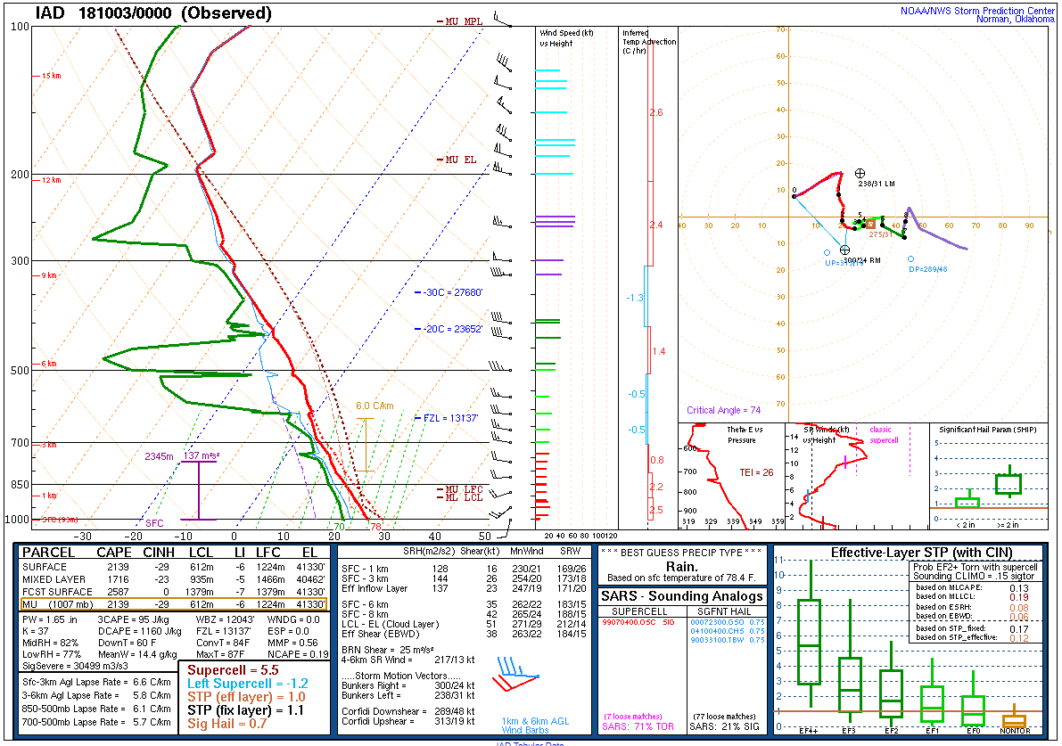
Synoptic Overview at 12z 2 Oct 2018 (courtesy of SPC)
 |
 |
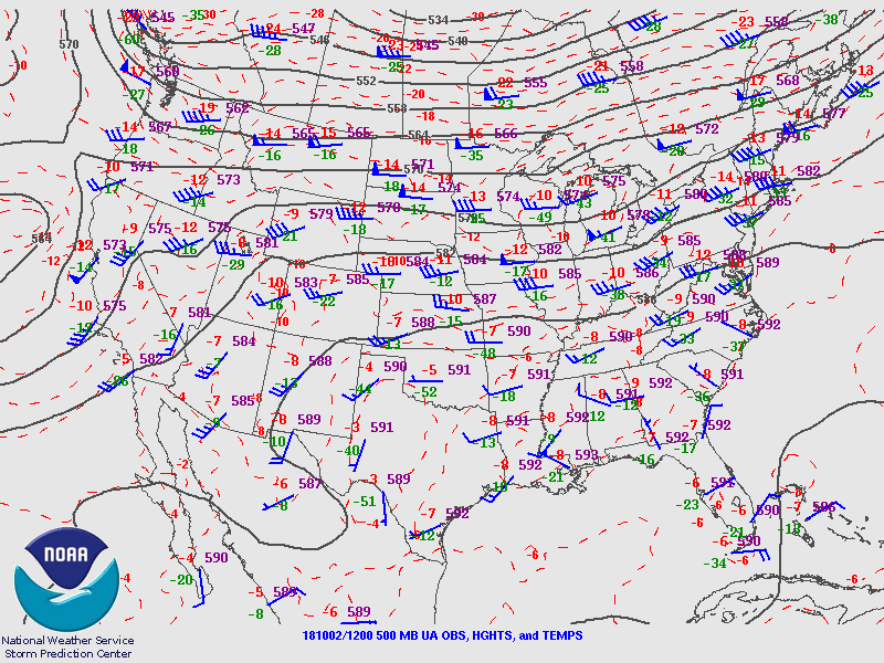 |
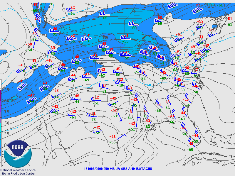
| Figure 1: 250-mb analysis | Figure 2: 300-mb analysis | Figure 3: 500-mb analysis |
 |
 |
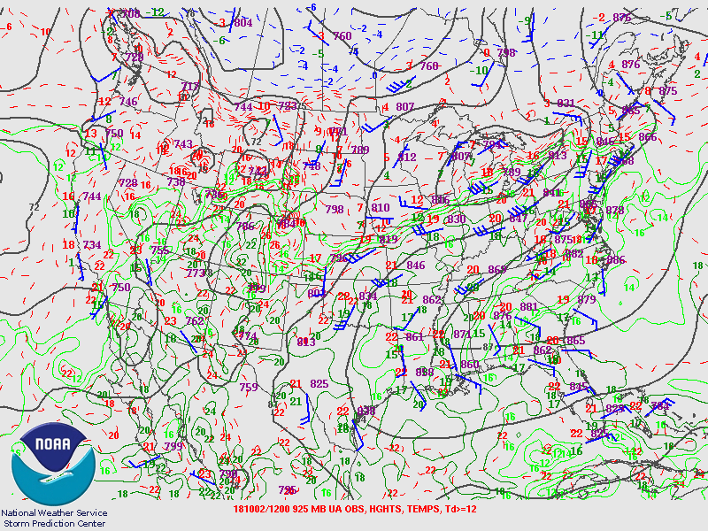 |
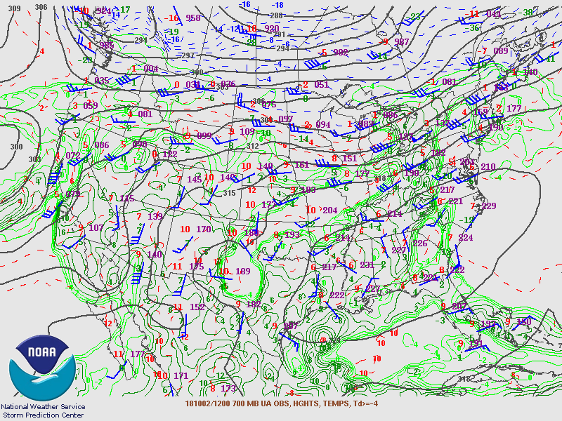
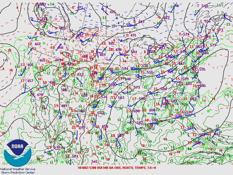
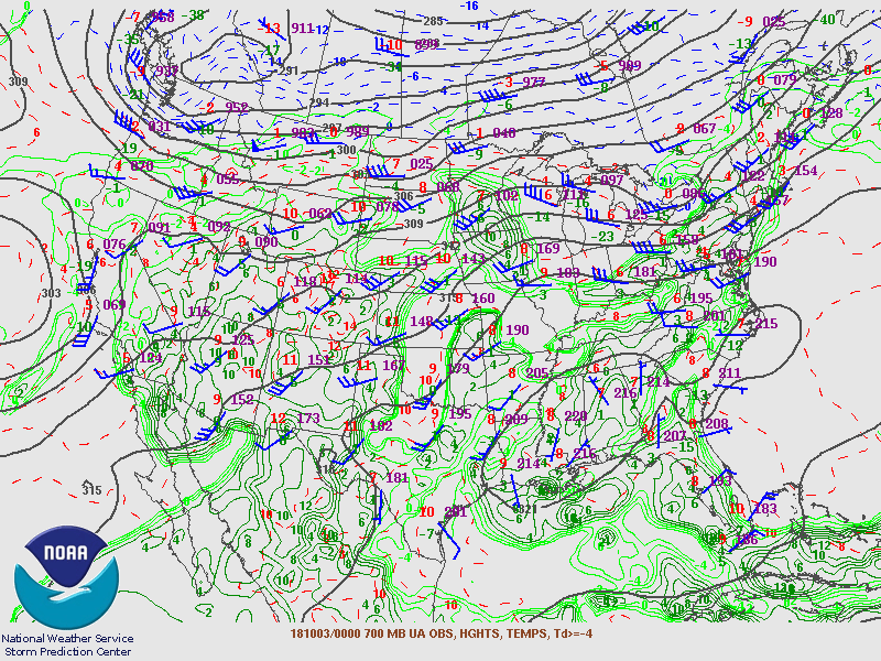
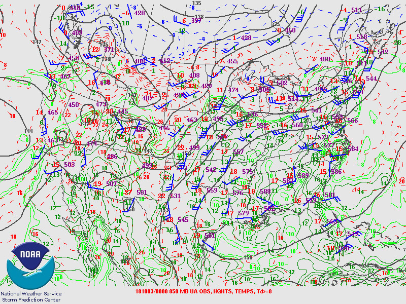
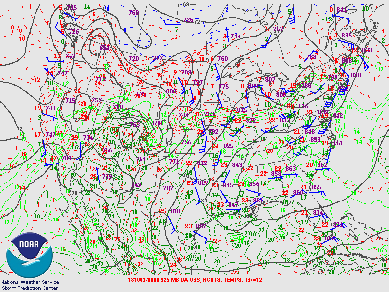
| Figure 4: 700-mb analysis | Figure 5: 850-mb analysis | Figure 6: 925-mb analysis |
Synoptic Overview at 00z 3 Oct 2018 (courtesy of SPC)
 |
 |
 |
| Figure 7: 250-mb analysis | Figure 8: 300-mb analysis | Figure 9: 500-mb analysis |
 |
 |
 |
| Figure 10: 700-mb analysis | Figure 11: 850-mb analysis | Figure 12: 925-mb analysis |
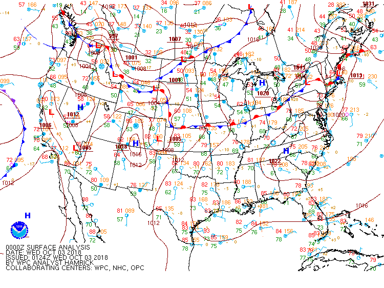
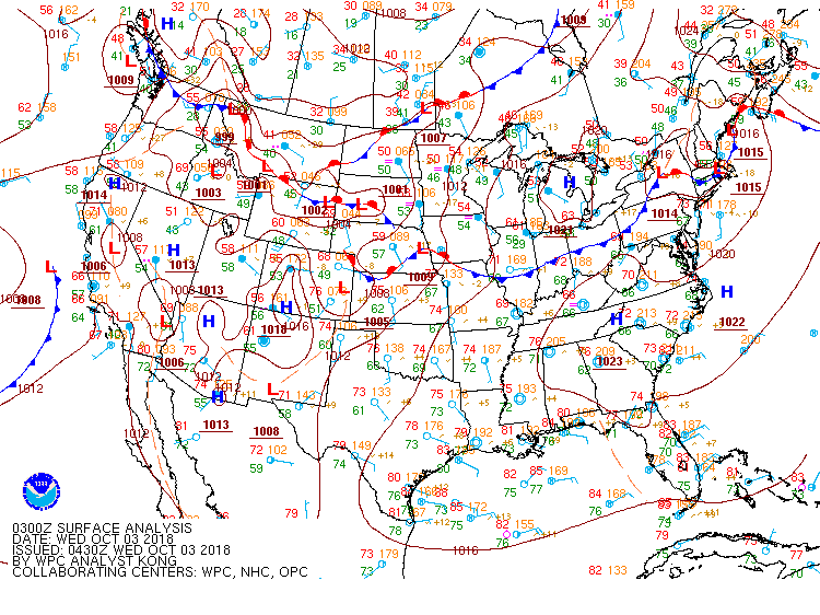
Surface Maps (courtesy of WPC)
 |
 |
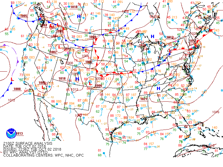 |
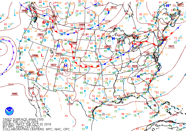
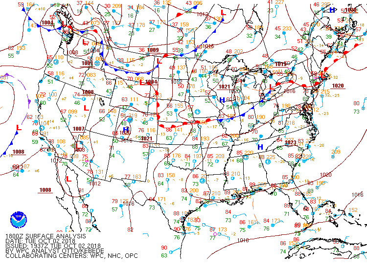
| Figure 13: 15z surface map | Figure 14: 18z surface map | Figure 15: 21z surface map |
 |
 |
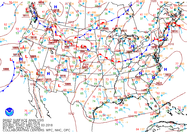 |
| Figure 16: 00z surface map | Figure 17: 03z surface map | Figure 18: 06z surface map |
 |
 |
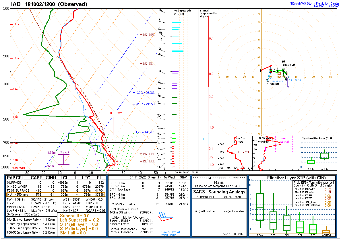 |
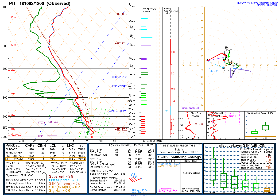
| Figure 19: 12z Upton, NY sounding | Figure 20: 12z Pittsburgh, PA sounding | Figure 21: 12z Sterling, VA sounding |
 |
 |
 |
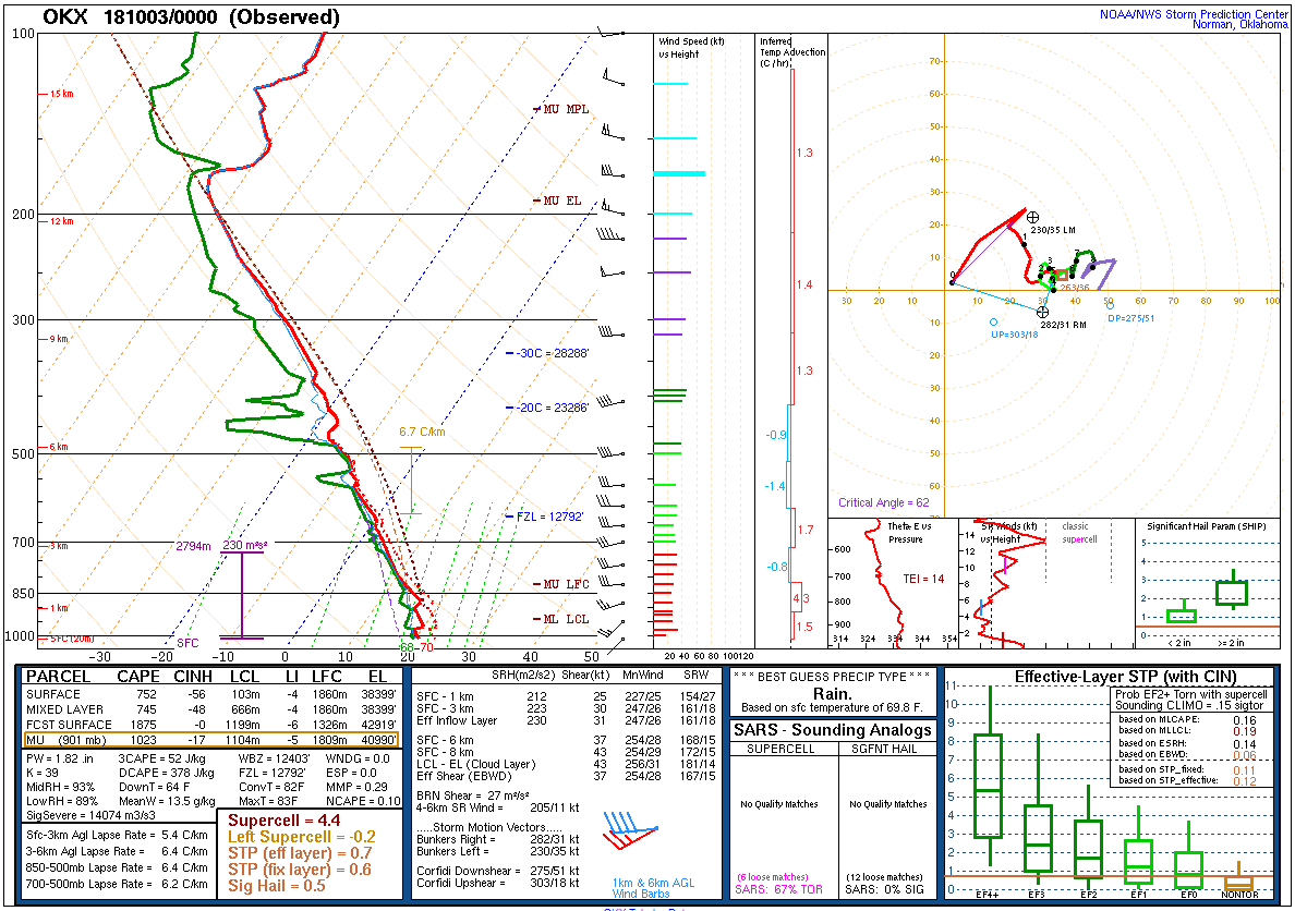
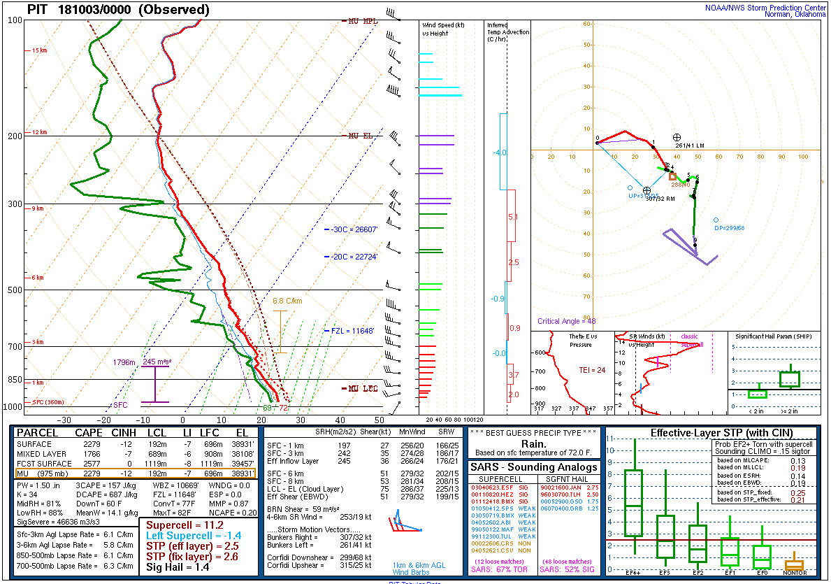
| Figure 22: 00z Upton, NY sounding | Figure 23: 00z Pittsburgh, PA sounding | Figure 24: 00z Sterling, VA sounding |
 |
 |
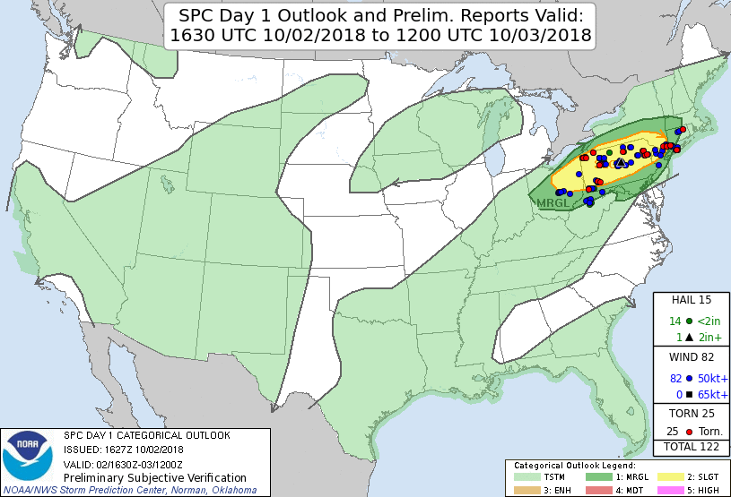 |
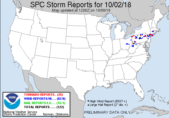
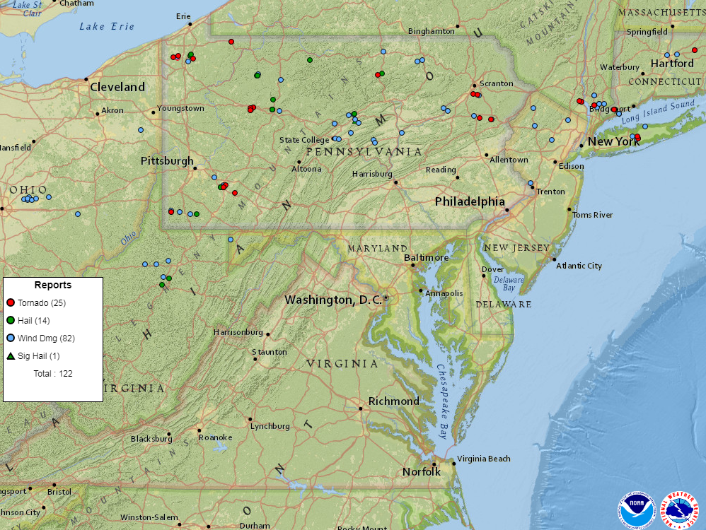
| Figure 1: National Preliminary Reports 12z 2 Oct 2018 to 12z 3 Oct 2018 | Figure 2: Zoomed Preliminary Reports | Figure 3: Prelim Reports vs. 1630z SPC Convective Outlook |
 |
 |
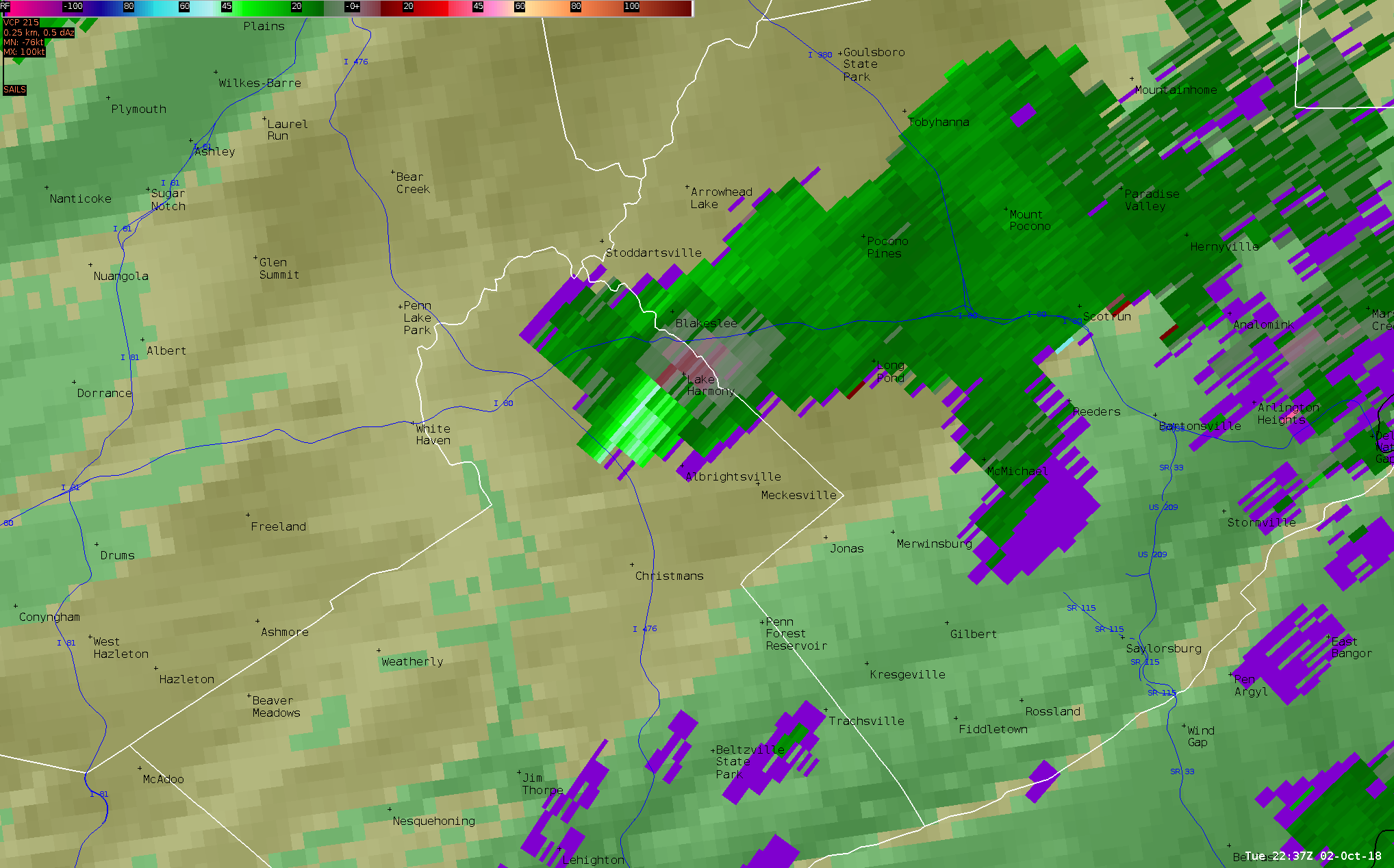 |
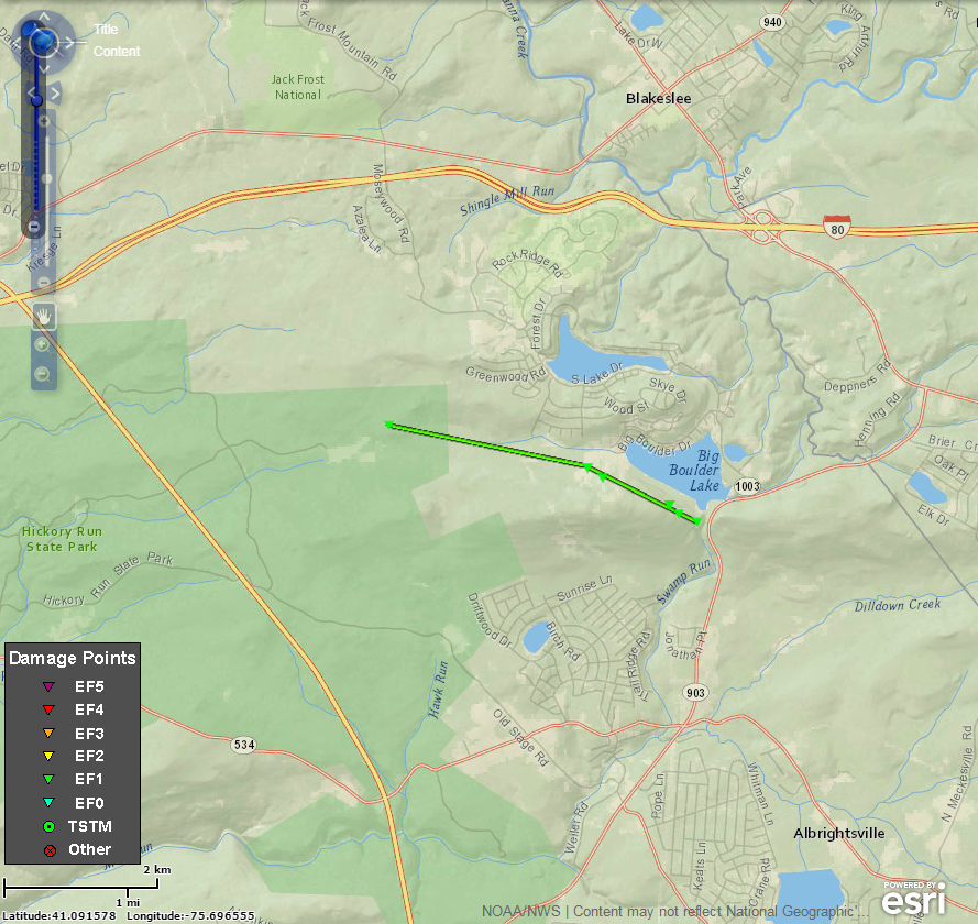
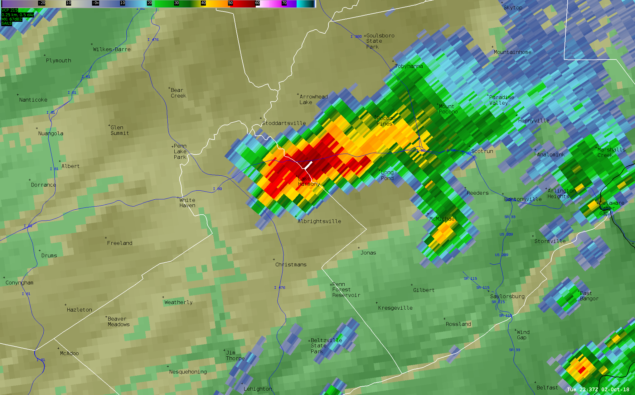
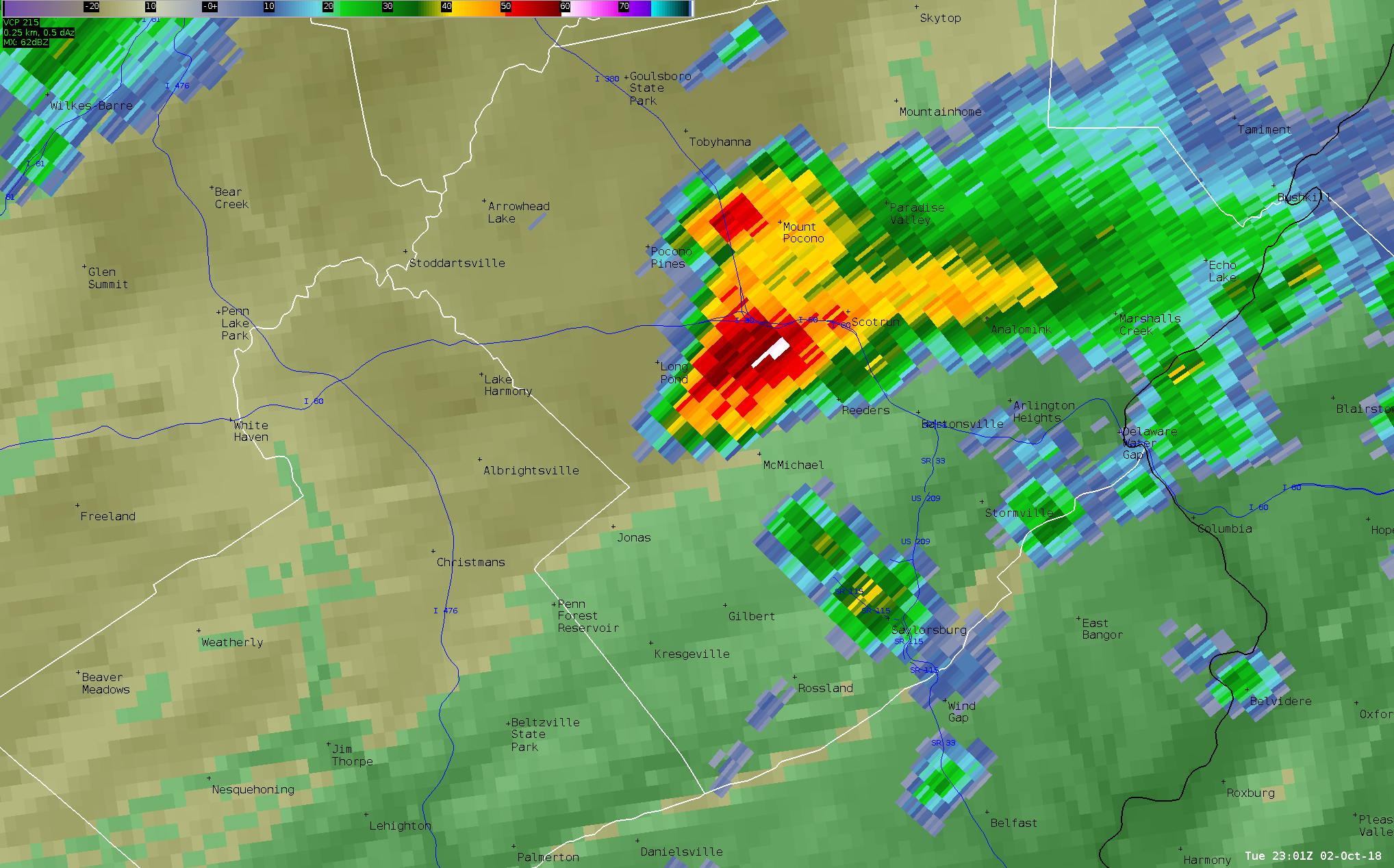
| Figure 1: Carbon County Tornado Track | Figure 2: Radar Reflectivity Factor Valid 6:37 pm EDT 2 Oct 2018 | Figure 3: Base Velocity Valid 6:37 pm EDT 2 Oct 2018 |
 |
 |
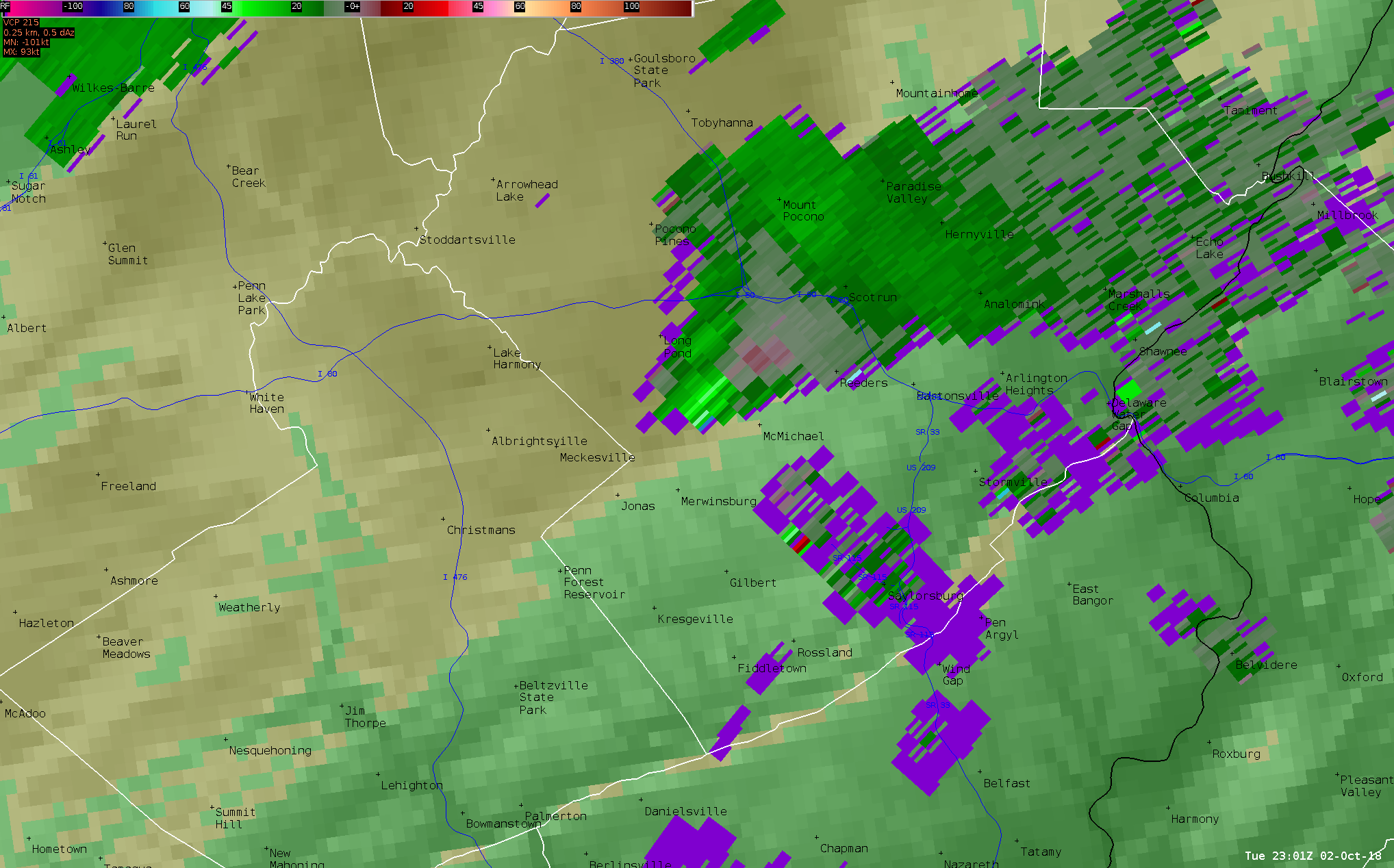 |
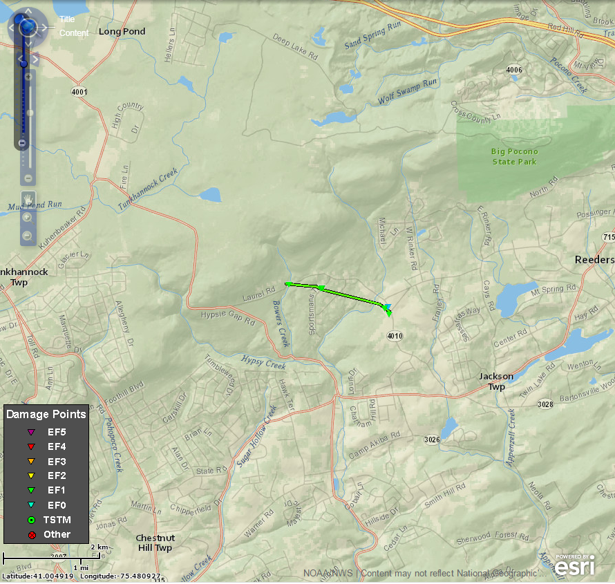
| Figure 1: Monroe County Tornado Track | Figure 2: Radar Reflectivity Factor Valid 7:01 pm EDT 2 Oct 2018 | Figure 3: Base Velocity Valid 7:01 pm EDT 2 Oct 2018 |
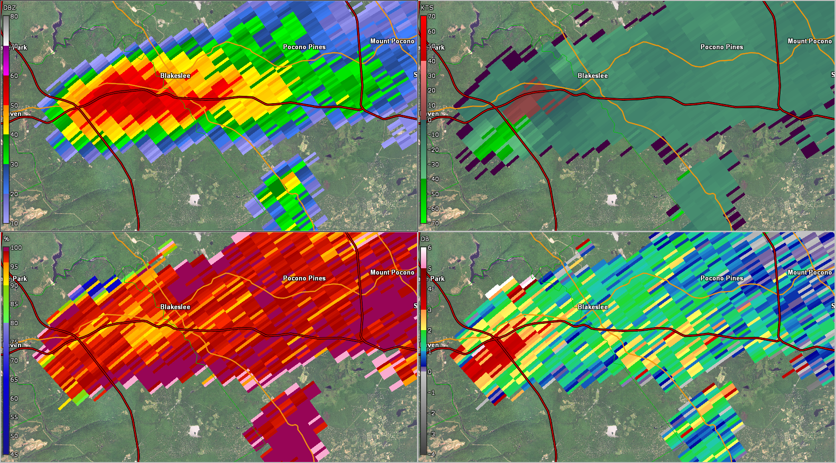
Carbon County Tornado (GR2Analyst)
 |
 |
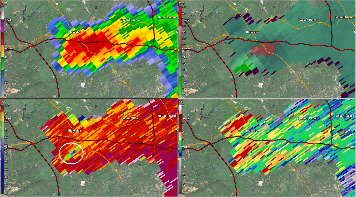 |
| Figure 1: Base radar reflectivity factor (top left), storm-relative velocity (top right), correlation coefficient (CC; bottom left), and differential radar reflectivity (ZDR; bottom right) valid at 2230 UTC 2 Oct 2018. | Figure 2: Same as Fig. 1, valid at 2235 UTC 2 Oct 2018. | Figure 3: Same as Fig. 1, valid at 2240 UTC 2 Oct 2018. Note the considerably lower values of CC (circled in white). The position of this signature is collocated with the center of the observed rotation (see the red marker in each of the panels). This is a strong indication of a tornadic debris signature (TDS). Making this particularly impressive is that the radar is identifying this signature well off the ground (around 9000 feet), since the radar is so far from the storm (approximately 86 nautical miles). |
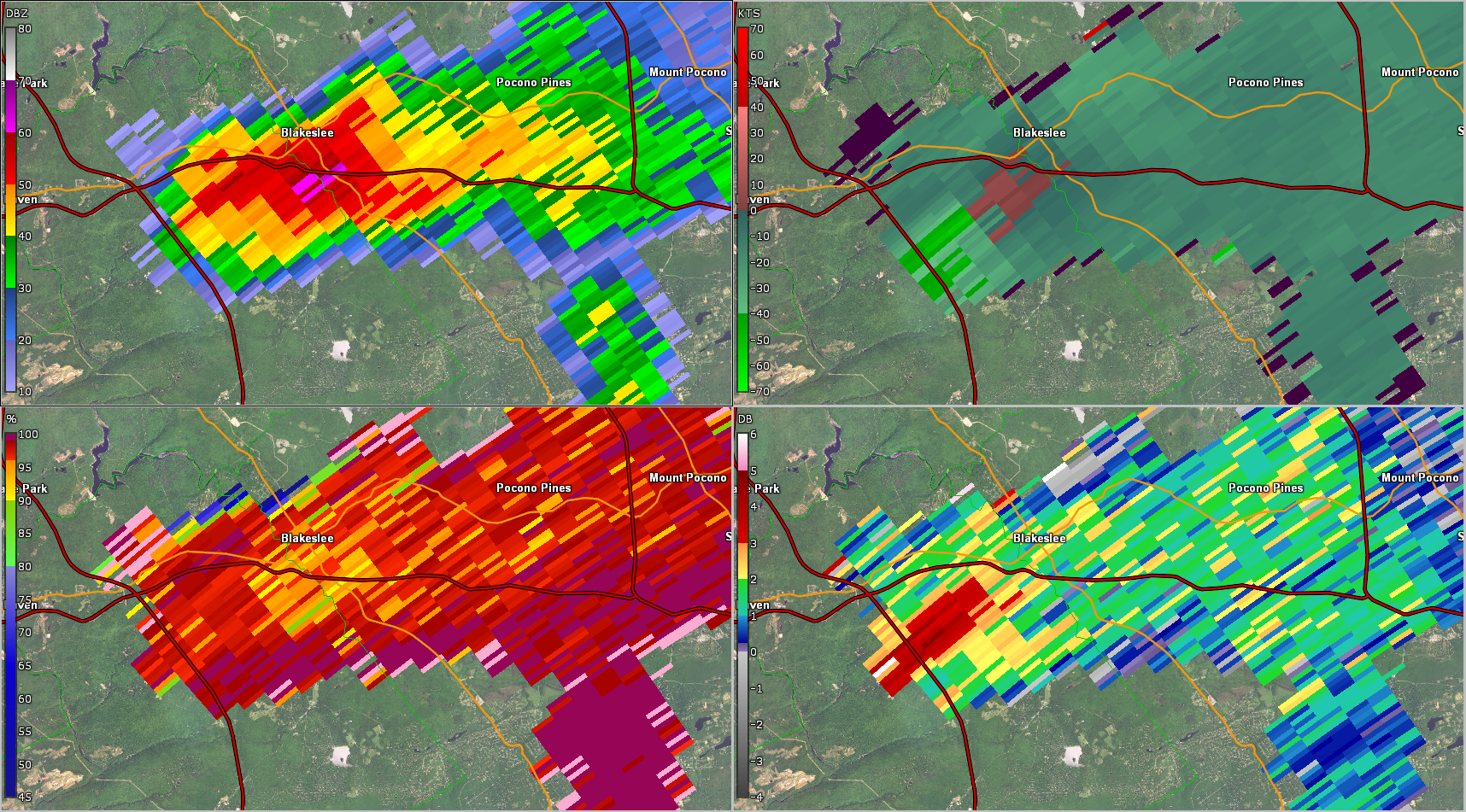
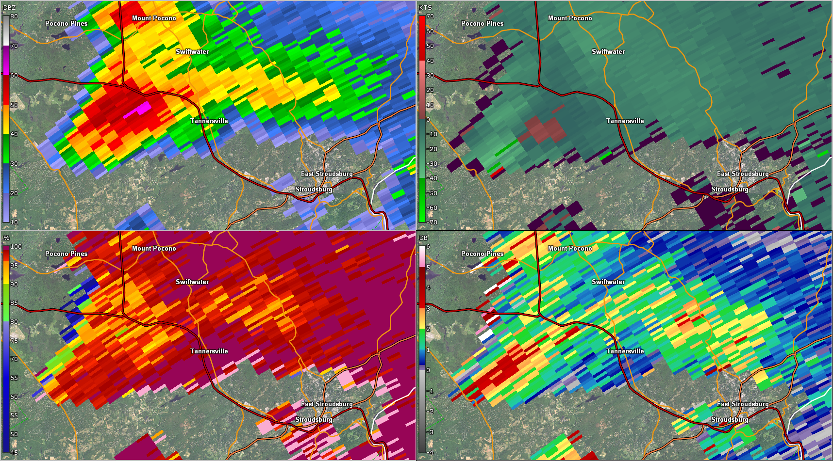
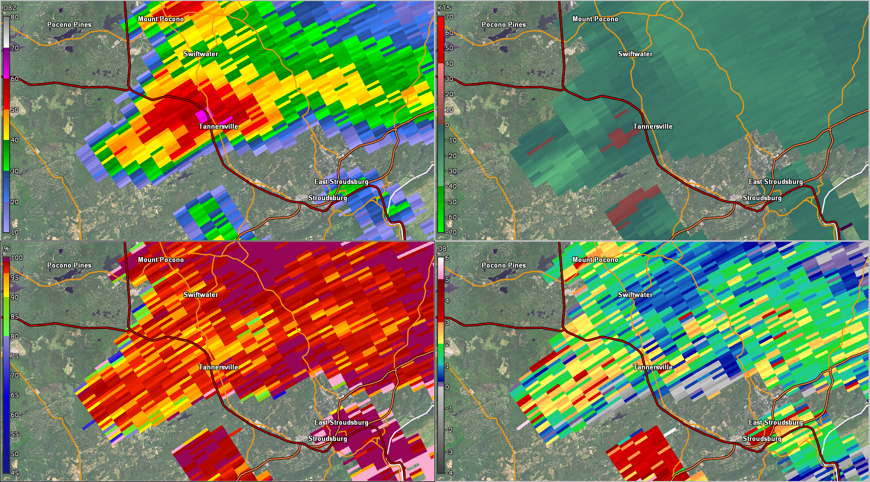
Monroe County Tornado (GR2Analyst)
 |
 |
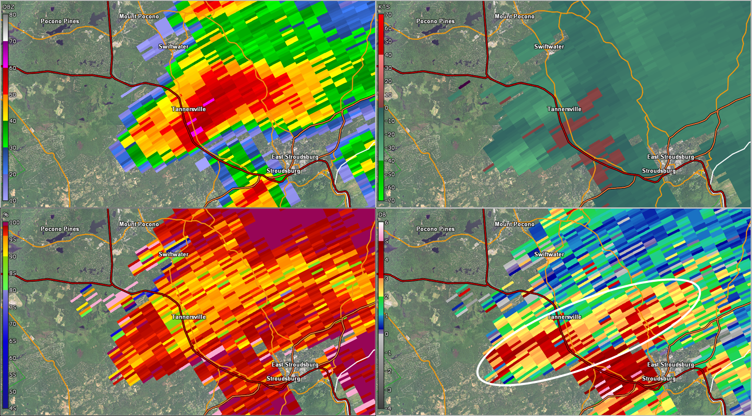 |
| Figure 4: Same as Fig. 1, valid at 2301 UTC 2 Oct 2018. | Figure 5: Same as Fig. 1, valid at 2306 UTC 2 Oct 2018. | Figure 6: Same as Fig. 1, valid at 2312 UTC 2 Oct 2018. Note the much higher values of ZDR (circled in white), indicative of the so-called ZDR arc -- a common signature with supercell storms. ZDR arcs depict size sorting of precipitation as a result of vertical wind shear -- i.e., a strong indication of (increasing) low- and midlevel rotation. |
Severe Thunderstorm Warning 0103
Tornado Warning 0004
Tornado Warning 0005
Severe Thunderstorm Warning 0104
Severe Thunderstorm Warning 0105
Tornado Warning 0006
Areal Flood Advisory 0316
Severe Thunderstorm Warning 0106
Areal Flood Advisory 0317
Severe Thunderstorm Warning 0107
Special Marine Warning 0112
Special Marine Warning 0113
NWUS51 KPHI 040006
LSRPHI

PRELIMINARY LOCAL STORM REPORT...SUMMARY
NATIONAL WEATHER SERVICE MOUNT HOLLY NJ
805 PM EDT WED OCT 03 2018

..TIME...   ...EVENT...      ...CITY LOCATION...     ...LAT.LON...
..DATE...   ....MAG....      ..COUNTY LOCATION..ST.. ...SOURCE....
            ..REMARKS..

0630 PM     TSTM WND DMG     1 E KIDDER TWP          41.06N  75.67W
10/02/2018                   CARBON             PA   911 CALL CENTER

            A COUPLE OF TREES REPORTED DOWN IN KIDDER TOWNSHIP.
            TIME ESTIMATED FROM RADAR.

0637 PM     TORNADO          1 S LAKE HARMONY        41.04N  75.59W
10/02/2018                   CARBON             PA   NWS STORM SURVEY

            TORNADO CAUSED TREE DAMAGE ALONG AN UNBROKEN PATH FROM
            THE BIG BOULDER SKI AREA ALONG A COMMUNICATIONS TOWER
            ACCESS ROAD NEAR BIG BOULDER LAKE. NUMEROUS TREES WERE
            UPROOTED AND SNAPPED. ESTIMATED MAXIMUM WIND SPEED WAS
            100 TO 110 MPH. TIME ESTIMATED FROM RADAR.

0701 PM     TORNADO          2 NNW MCMICHAEL         41.02N  75.41W
10/02/2018                   MONROE             PA   NWS STORM SURVEY

            THE PATH OF THIS TORNADO STARTED WITH TREE DAMAGE ALONG
            JACKSON ROAD. MANY TREES WERE UPROOTED AND SOME WERE
            SNAPPED. ADDITIONAL TREE DAMAGE WAS OBSERVED ALONG
            SPORTSMANS TRAIL AND SKYHAWK TRAIL. THE DAMAGE PATH
            CONTINUED THROUGH A CORN FIELD NEAR THE INTERSECTION OF
            MOUNTAIN ROAD AND JACKSON ROAD. A LARGE LIMB OF
            APPROXIMATELY 18 INCHES IN DIAMETER WAS SNAPPED OFF A
            TREE AND CAUSED ROOF DAMAGE AND DOWNED POWER LINES TO A
            RESIDENCE. ESTIMATED MAXIMUM WIND SPEED WAS 90 TO 100
            MPH. TIME ESTIMATED

0833 PM     TSTM WND DMG     BYRAM TWP               40.95N  74.73W
10/02/2018                   SUSSEX             NJ   EMERGENCY MNGR

            LOCALIZED POWER OUTAGES AND TREES DOWN. TIME ESTIMATED
            FROM RADAR.

0850 PM     TSTM WND DMG     BRANCHVILLE             41.15N  74.75W
10/02/2018                   SUSSEX             NJ   EMERGENCY MNGR

            LOCALIZED TREE DAMAGE AND POWER OUTAGES. TIME ESTIMATED
            FROM RADAR.

0947 PM     TSTM WND DMG     1 ESE MORRISTOWN        40.78N  74.46W
10/02/2018                   MORRIS             NJ   911 CALL CENTER

            TREE DOWN ON BRADWAHL DRIVE.

1000 PM     HAIL             1 N FRENCHTOWN          40.53N  75.06W
10/02/2018  M0.25 INCH       HUNTERDON          NJ   COCORAHS

            NO DAMAGE REPORTED.

1015 PM     HAIL             HATFIELD                40.28N  75.30W
10/02/2018  E0.80 INCH       MONTGOMERY         PA   SOCIAL MEDIA

            2 CM HAIL REPORTED IN HATFIELD. TIME ESTIMATED FROM
            RADAR.

1055 PM     TSTM WND DMG     EWING                   40.27N  74.80W
10/02/2018                   MERCER             NJ   TRAINED SPOTTER

            TREE UPROOTED ONTO A HOUSE ON KING AVE. MINOR
            STRUCTURAL DAMAGE. DOWNED POWER LINES IN AREA.


&&

EVENT NUMBER PHI1801637 PHI1801645 PHI1801646 PHI1801643 PHI1801644
PHI1801641 PHI1801640 PHI1801639 PHI1801638


$$

SFJ
NOUS41 KPHI 092349
PNSPHI
DEZ001>004-MDZ008-012-015-019-020-NJZ001-007>010-012>027-PAZ054-
055-060>062-070-071-101>106-101200-

Public Information Statement
National Weather Service Mount Holly NJ
749 PM EDT Tue Oct 9 2018

...NWS DAMAGE SURVEY FOR 10/02/18 TORNADO EVENT...

.Carbon County Tornado...

Start Location...Lake Harmony in Carbon County Pennsylvania
End Location...Lake Harmony in Carbon County Pennsylvania
Date...October 2 2018
Estimated Time...6:36 EDT
Maximum EF-Scale Rating...EF1
Estimated Maximum Wind Speed...100-110 mph
Maximum Path Width...40 yards
Path Length...2.67 miles
Beginning Lat/Lon...41.0533/-75.6358
Ending Lat/Lon...41.042/-75.5876
* Fatalities...0
* Injuries...0

...Summary...
A funnel cloud was witnessed by a local citizen. Several trees
were uprooted and snapped along the path of the tornado, though
the tornado may have lifted a few times. Tree damage and damage to
a ski lift occurred at the Big Boulder Ski area. Tree damage
continued along an unbroken path from the ski area along a
communications tower access road near Big Boulder Lake.

.Monroe County Tornado...

Start Location...Jackson Township in Monroe County Pennsylvania
End Location...Jackson Township in Monroe County Pennsylvania
Date...October 2 2018
Estimated Time...7:01 PM
Maximum EF-Scale Rating...EF1
Estimated Maximum Wind Speed...90-100 mph
Maximum Path Width...50 yards
Path Length...1.42 miles
Beginning Lat/Lon...41.0158/-75.4114
Ending Lat/Lon...41.0108/-75.3855
* Fatalities...0
* Injuries...0

...Summary...
The path of this tornado started with tree damage along Jackson
road. Many trees were uprooted and some were snapped. The damage
path veered slightly toward the southeast where additional tree
damage was observed along Sportsmans Trail and Skyhawk Trail.
The damage path continued through a corn field near the
intersection of Mountain Road and Jackson Road. A large limb of
approximately 18 inches in diameter was snapped off a tree and
caused roof damage and downed power lines to a residence.

EF Scale: The Enhanced Fujita Scale classifies tornadoes into the
following categories:

EF0...Weak......65 to 85 mph
EF1...Weak......86 to 110 mph
EF2...Strong....111 to 135 mph
EF3...Strong....136 to 165 mph
EF4...Violent...166 to 200 mph
EF5...Violent...>200 mph

* The information in this statement is preliminary and subject to
change pending final review of the events and publication in NWS
Storm Data.

$$


 Coastal Flood
 Marine Forecasts
 Text Products
 Climate Information
 Skywarn
 Submit Storm Report
 Weather Event Archives
 Forecast Discussion
 Emergency Managers
 Briefing Page