Overview
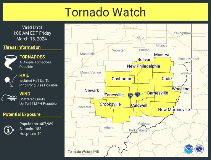
During the afternoon and evening hours of March 14th 2024, a strong low pressure system developed over the lower Midwest States. This, along with favorable upper level dynamics setup as strong to severe thunderstorms began to develop over the Indiana and into western Ohio. The setup resulted in numerous strong tornadoes over Indiana and into western Ohio. The system weakened a bit as it moved east. As the convection began to move into eastern Ohio, the environment was supportive of severe storms but not strong enough for tornadic development. The storms that began to move through eastern Ohio and into the West Virginia Panhandle and southwestern Pennsylvania resulted in some large hail being produced. Hail was the main threat posed by the storms. Rainfall was a concern in some spots.
 |
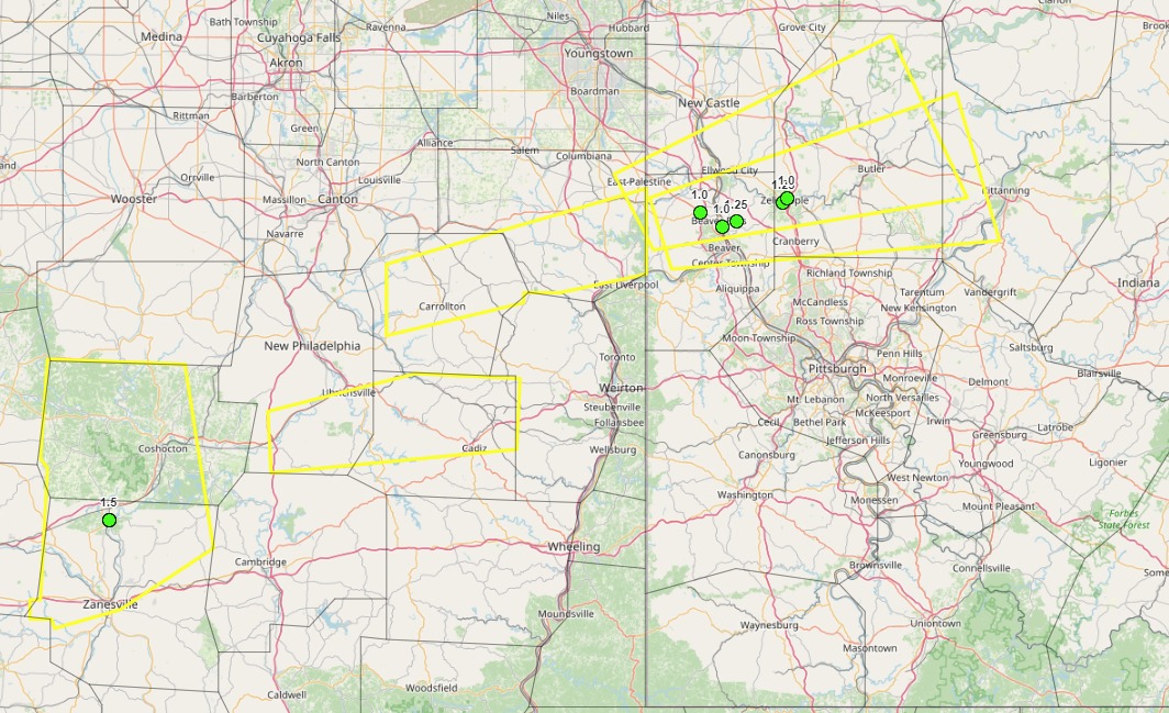 |
| Tornado Watch | Severe Thunderstorm Warning Map |
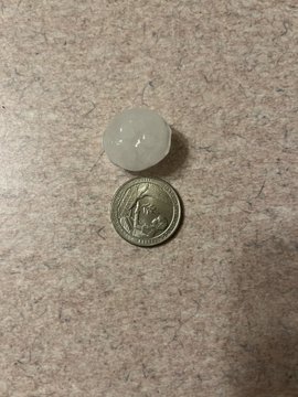
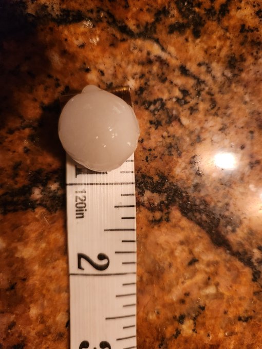
Photos
Header
 |
 |
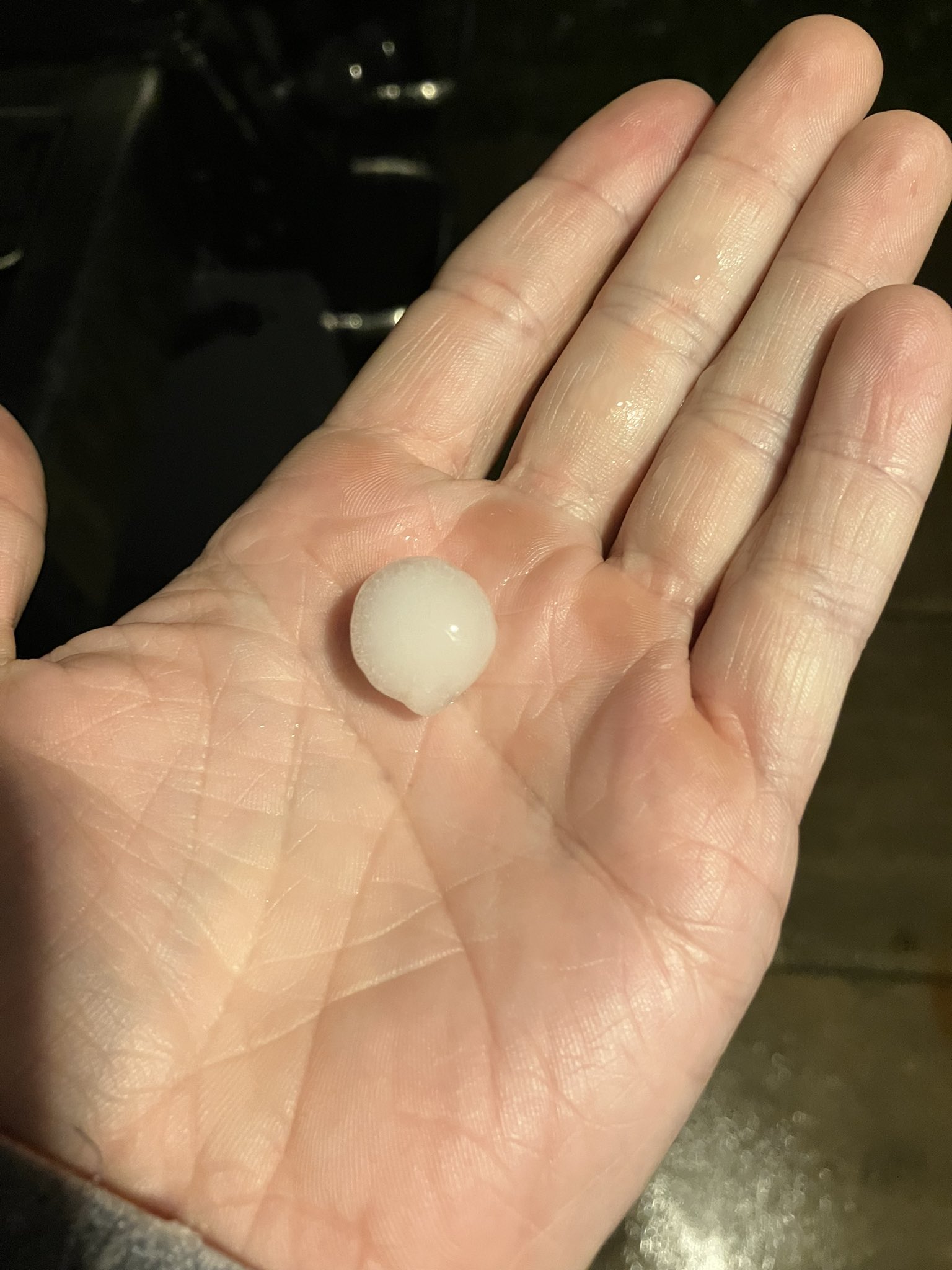 |
| Chippewa, PA Credit: Molly Watterson |
Daugherty Township, PA Credit: New Brighton |
Evans City, PA Credit: London Sasse |
Radar
Header
 |
 |
| Radar Loop 1 | Radar Loop 2 |
Storm Reports
Preliminary Local Storm Report...Summary
National Weather Service Pittsburgh PA
245 PM EDT Sat Mar 16 2024
..TIME... ...EVENT... ...CITY LOCATION... ...LAT.LON...
..DATE... ....MAG.... ..COUNTY LOCATION..ST.. ...SOURCE....
| 0810 PM | Hail | Lisbon | 40.78N | 80.77W | ||
| 3/14/2024 | M0.75 | inch | Columbiana | OH | Public | |
| 0854 PM | Hail | 1 W Blackhawk | 40.71N | 80.48W | ||
| 3/14/2024 | M0.75 | inch | Beaver | PA | Public | |
| 0855 PM | Hail | 1 E Kenwood | 40.75N | 80.27W | ||
| 3/14/2024 | E1.25 | inch | Beaver | PA | Public | |
| 0900 PM | Hail | 2 WSW West Mayfie | ld | 40.77N | 80.37W | |
| 3/14/2024 | M1.00 | inch | Beaver | PA | Public | |
| 0903 PM | Hail | New Brighton | 40.74N | 80.31W | ||
| 3/14/2024 | M1.00 | inch | Beaver | PA | Public | |
| 0907 PM | Hail | Zelienople | 40.79N | 80.14W | ||
| 3/14/2024 | E1.25 | inch | Butler | PA | Public | |
| 0909 PM | Hail | Harmony | 40.80N | 80.13W | ||
| 3/14/2024 | M1.00 | inch | Butler | PA | Public | |
| 0910 PM | Hail | 2 NNE Petersville | 40.84N | 79.99W | ||
| 3/14/2024 | E0.88 | inch | Butler | PA | Emergen | cy Mngr |
| 0910 PM | Hail | Beaver | 40.69N | 80.31W | ||
| 3/14/2024 | M0.88 | inch | Beaver | PA | Public | |
| 0914 PM | Hail | 1 E Meridian | 40.85N | 79.94W | ||
| 3/14/2024 | M0.88 | inch | Butler | PA | Public | |
| 0917 PM | Hail | Butler | 40.86N | 79.90W | ||
| 3/14/2024 | E0.88 | inch | Butler | PA | Public | |
| 0921 PM | Hail | Dresden | 40.12N | 82.01W | ||
| 3/14/2024 | M1.00 | inch | Muskingum | OH | Public | |
| 0923 PM | Hail | Dresden | 40.12N | 82.01W | ||
| 3/14/2024 | E1.50 | inch | Muskingum | OH | Public | |
| 0930 PM | Hail | Port Washington | 40.33N | 81.52W | ||
| 3/14/2024 | E1.00 | inch | Tuscarawas | OH | Public | |
| 0932 PM | Hail | 2 N Newcomerstown | 40.30N | 81.60W | ||
| 3/14/2024 | M0.75 | inch | Tuscarawas | OH | Trained | Spotter |
| 0948 PM | Hail | 1 ENE Hartwood | 40.28N | 81.47W | ||
| 3/14/2024 | E1.25 | inch | Tuscarawas | OH | Public | |
| 0950 PM | Hail | New Harrisburg | 40.62N | 81.15W | ||
| 3/14/2024 | E0.88 | inch | Carroll | OH | Public | |
| 1000 PM | Hail | Blackhawk | 40.71N | 80.46W | ||
| 3/14/2024 | M0.75 | inch | Beaver | PA | Public | |
| 1015 PM | Hail | Beaver | 40.69N | 80.31W | ||
| 3/14/2024 | M0.75 | inch | Beaver | PA | Public |
Rain Reports
Public Information Statement
Spotter Reports
National Weather Service Pittsburgh PA
244 PM EDT Sat Mar 16 2024
The following are unofficial observations taken during the past 72
hours for the storm that has been affecting our region. Appreciation
is extended to highway departments, cooperative observers, Skywarn
spotters and media for these reports. This summary also is available
on our home page at weather.gov/pittsburgh
***********24 HOUR RAINFALL (AT LEAST 0.50 INCH)************
LOCATION 24 HOUR TIME/DATE COMMENTS
RAINFALL
MEASURED
(inches)
| MARYLAND | |||||
| ...Garrett County... | |||||
| 2 ESE Grantsville | 0.66 | 650 | AM | 15-Mar | CoCoRaHS |
| OHIO | |||||
| ...Belmont County... | |||||
| 6 SE Belmont | 0.52 | 400 | AM | 15-Mar | Mesonet |
| ...Columbiana County... | |||||
| 1 W Washingtonville | 0.79 | 745 | AM | 15-Mar | Mesonet |
| 2 SSW Leetonia | 0.77 | 600 | AM | 15-Mar | CoCoRaHS |
| Columbiana | 0.75 | 816 | AM | 15-Mar | Mesonet |
| NNE Columbiana | 0.67 | 620 | AM | 15-Mar | CoCoRaHS |
| ...Coshocton County... | |||||
| 3 N Coshocton | 0.8 | 800 | AM | 15-Mar | Mesonet |
| Nellie | 0.67 | 815 | AM | 15-Mar | Mesonet |
| 3 SE Conesville | 0.57 | 745 | AM | 15-Mar | Mesonet |
| 2 NNE Fresno | 0.55 | 800 | AM | 15-Mar | CoCoRaHS |
| ...Guernsey County... | |||||
| Pleasant City | 1.32 | 600 | AM | 15-Mar | Mesonet |
| 1 NE Pleasant City | 1.19 | 800 | AM | 15-Mar | Mesonet |
| Cambridge | 1.18 | 900 | AM | 15-Mar | CoCoRaHS |
| 3 NE Cambridge | 1 | 800 | AM | 15-Mar | CoCoRaHS |
| 1 E Cambridge | 0.97 | 700 | AM | 15-Mar | CoCoRaHS |
| 3 SE Kimbolton | 0.52 | 745 | AM | 15-Mar | Mesonet |
| ...Harrison County... | |||||
| 1 W Jewett | 0.52 | 800 | AM | 15-Mar | Mesonet |
| ...Monroe County... | |||||
| 1 W New Martinsville | 1.03 | 800 | AM | 15-Mar | Mesonet |
| Antioch | 1 | 500 | AM | 15-Mar | Mesonet |
| 3 E Woodsfield | 0.88 | 800 | AM | 15-Mar | Mesonet |
| 9 ENE Lower Salem | 0.77 | 700 | AM | 15-Mar | CoCoRaHS |
| Merrell Ridge | 0.72 | 732 | AM | 15-Mar | Mesonet |
| ...Muskingum County... | |||||
| Zanesville Airport | 1.37 | 813 | AM | 15-Mar | ASOS |
| 1 SE Norwich | 1.29 | 700 | AM | 15-Mar | CoCoRaHS |
| 3 ENE Zanesville | 1.15 | 730 | AM | 15-Mar | CoCoRaHS |
| 4 NW Zanesville | 0.76 | 815 | AM | 15-Mar | Mesonet |
| Adamsville | 0.6 | 1200 | AM | 15-Mar | Mesonet |
| ...Noble County... | |||||
| 4 SE Senecaville | 1.18 | 700 | AM | 15-Mar | CoCoRaHS |
| Summerfield | 0.92 | 810 | AM | 15-Mar | Mesonet |
| PENNSYLVANIA | |||||
| ...Armstrong County... | |||||
| 1 NNE New Kensington | 0.75 | 812 | AM | 15-Mar | Mesonet |
| 1 SSW Kittanning | 0.67 | 700 | AM | 15-Mar | CoCoRaHS |
| West Kittanning | 0.66 | 800 | AM | 15-Mar | Mesonet |
| 4 SE East Brady | 0.62 | 800 | AM | 15-Mar | Mesonet |
| 6 SW Kittanning | 0.61 | 830 | AM | 15-Mar | CoCoRaHS |
| ...Beaver County... | |||||
| 2 WSW Zelienople | 0.6 | 820 | AM | 15-Mar | Mesonet |
| Fombell | 0.53 | 818 | AM | 15-Mar | Mesonet |
| ...Butler County... | |||||
| 2 W Butler | 0.93 | 700 | AM | 15-Mar | CoCoRaHS |
| West Sunbury | 0.82 | 815 | AM | 15-Mar | Mesonet |
| 1 SW Meridian | 0.74 | 800 | AM | 15-Mar | CoCoRaHS |
| 3 NNE Shanor-Northvu | 0.7 | 700 | AM | 15-Mar | CoCoRaHS |
| N Cabot | 0.67 | 700 | AM | 15-Mar | CoCoRaHS |
| 2 NE Sarver | 0.67 | 500 | AM | 15-Mar | CoCoRaHS |
| Karns City | 0.65 | 818 | AM | 15-Mar | Mesonet |
| 7 SW Butler | 0.64 | 800 | AM | 15-Mar | CoCoRaHS |
| 2 SSW Evans City | 0.64 | 800 | AM | 15-Mar | CoCoRaHS |
| 2 WNW Cabot | 0.63 | 700 | AM | 15-Mar | CoCoRaHS |
| Moraine State Park | 0.6 | 750 | AM | 15-Mar | Mesonet |
| 1 N Harmony | 0.55 | 820 | AM | 15-Mar | Mesonet |
| ...Clarion County... | |||||
| Leeper | 0.83 | 815 | AM | 15-Mar | Mesonet |
| 3 SW Clarion | 0.51 | 700 | AM | 15-Mar | Co-Op Observer |
| ...Fayette County... | |||||
| 1 ENE Farmington | 0.78 | 700 | AM | 15-Mar | CoCoRaHS |
| 6 SW Ohiopyle | 0.61 | 800 | AM | 15-Mar | Mesonet |
| ...Forest County... | |||||
| 7 SSE Tionesta | 1.01 | 700 | AM | 15-Mar | CoCoRaHS |
| 5 W Marienville | 0.53 | 620 | AM | 15-Mar | CoCoRaHS |
| 1 S Tionesta | 0.52 | 745 | AM | 15-Mar | Mesonet |
| ...Greene County... | |||||
| 1 E Waynesburg | 0.61 | 700 | AM | 15-Mar | Co-Op Observer |
| 1 ESE Graysville | 0.61 | 800 | AM | 15-Mar | Mesonet |
| 1 SW Point Marion | 0.6 | 600 | AM | 15-Mar | Co-Op Observer |
| Waynesburg | 0.55 | 816 | AM | 15-Mar | Mesonet |
| 2 SSW Wind Ridge | 0.5 | 830 | AM | 15-Mar | CoCoRaHS |
| WNW Carmichaels | 0.5 | 800 | AM | 15-Mar | CoCoRaHS |
| ...Jefferson County... | |||||
| Brookville | 0.7 | 800 | AM | 15-Mar | Mesonet |
| ...Lawrence County... | |||||
| 5 NNW Portersville | 0.91 | 700 | AM | 15-Mar | CoCoRaHS |
| New Castle Airport | 0.84 | 756 | AM | 15-Mar | AWOS |
| WNW New Wilmington | 0.54 | 739 | AM | 15-Mar | CoCoRaHS |
| ...Mercer County... | |||||
| 3 N Slippery Rock | 0.5 | 815 | AM | 15-Mar | Mesonet |
| ...Venango County... | |||||
| Franklin Airport | 1.29 | 756 | AM | 15-Mar | AWOS |
| 1 NW Rouseville | 0.94 | 745 | AM | 15-Mar | Mesonet |
| 1 E Cooperstown | 0.83 | 800 | AM | 15-Mar | CoCoRaHS |
| NW Reno | 0.64 | 600 | AM | 15-Mar | CoCoRaHS |
| ...Westmoreland County... | |||||
| 2 NW Donegal | 0.6 | 700 | AM | 15-Mar | Co-Op Observer |
| WEST VIRGINIA | |||||
| ...Marion County... | |||||
| 2 N Rivesville | 0.98 | 600 | AM | 15-Mar | CoCoRaHS |
| 3 ENE Fairmont | 0.71 | 700 | AM | 15-Mar | CoCoRaHS |
| ...Marshall County... | |||||
| 4 NW Littleton | 0.76 | 300 | AM | 15-Mar | Mesonet |
| 4 SSW Moundsville | 0.71 | 700 | AM | 15-Mar | CoCoRaHS |
| ...Monongalia County... | |||||
| MORGANTOWN | 1.12 | 819 | AM | 15-Mar | Mesonet |
| 6 SW Morgantown | 0.99 | 700 | AM | 15-Mar | CoCoRaHS |
| 4 NE Rivesville | 0.96 | 800 | AM | 15-Mar | Mesonet |
| 6 WSW Morgantown | 0.78 | 700 | AM | 15-Mar | CoCoRaHS |
| Morgantown Airport | 0.76 | 818 | AM | 15-Mar | ASOS |
| Morgantown Dam | 0.7 | 600 | AM | 15-Mar | Co-Op Observer |
| Morgantown | 0.66 | 818 | AM | 15-Mar | Mesonet |
| ...Ohio County... | |||||
| Bethlehem | 1.08 | 800 | AM | 15-Mar | Mesonet |
| 2 S Valley Grove | 0.95 | 800 | AM | 15-Mar | Mesonet |
| 3 N Wheeling | 0.5 | 600 | AM | 15-Mar | Co-Op Observer |
| ...Preston County... | |||||
| 5 NNE Terra Alta | 0.91 | 800 | AM | 15-Mar | CoCoRaHS |
| 5 S Newburg | 0.84 | 600 | AM | 15-Mar | Mesonet |
| 3 S Bruceton Mills | 0.77 | 700 | AM | 15-Mar | CoCoRaHS |
| 9 SE Bruceton Mills | 0.75 | 900 | AM | 15-Mar | CoCoRaHS |
| E Terra Alta | 0.7 | 700 | AM | 15-Mar | CoCoRaHS |
| Cheat River | 0.69 | 745 | AM | 15-Mar | Mesonet |
| Bruceton Mills | 0.61 | 815 | AM | 15-Mar | Mesonet |
| ...Wetzel County... | |||||
| 7 E New Martinsville | 1.03 | 800 | AM | 15-Mar | CoCoRaHS |
| 2 N Glover Gap | 0.78 | 230 | AM | 15-Mar | Co-Op Observer |
Environment
Upper Air Maps from SPC.
March 15th 2024 00Z.
 |
 |
 |
| 250MB | 300MB | 500MB |
 |
 |
 |
| 700MB | 850MB | 925MB |
Surface Analyzed Maps from WPC.
 |
 |
 |
| March 14th 2024 18Z | March 14th 2024 21Z | March 15th 2024 00Z |
 |
 |
 |
| March 15th 2024 03Z | March 15th 2024 06Z | March 15th 2024 09Z |
Upper Air Sounding from PIT.
 |
| March 15th 2024 00Z |
 |
Media use of NWS Web News Stories is encouraged! Please acknowledge the NWS as the source of any news information accessed from this site. |
|

