Overview
|
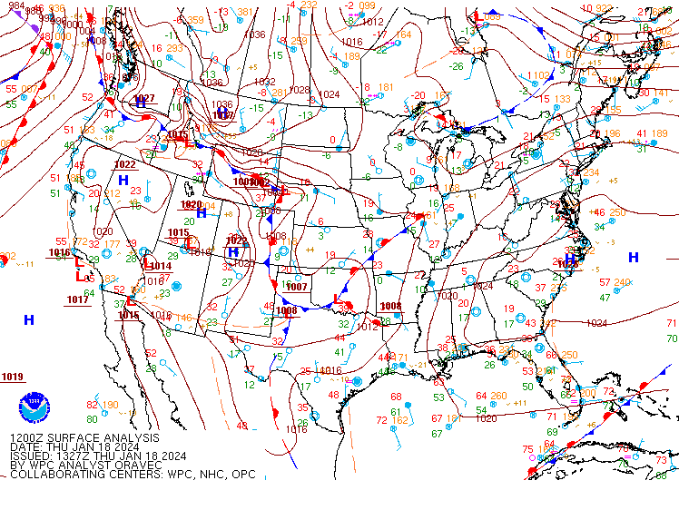
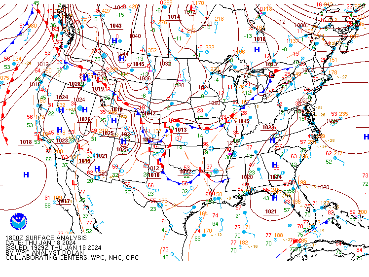
During the early morning hours on January 18th 2024, a surface low pressure system began to develop over the southeast CONUS. The surface low further developed as it tracked northeast along the Appalachian range. The deformation snowfall begin to develop just to the south along the northern WV areas and just south of the forecast area. The area of development did eventually move north as it overcame a low level dry area in the profile. However, the frontogenic banding was weaker than forecasted and came in with lower snowfall amounts than forecasted through the day on Thursday. By Thursday evening and Thursday night, the surface low pushed off to the east and off the East Coast. Behind the front, during the early morning hours of January 19th, the lake enhanced upslope began as a post frontal trough assisted in snow shower development. The snow showers produced heavy snowfall at times and quickly made up for the lack of snow during the synoptic snowfall period. This also resulted in a banded snowfall event that will be further discussed during the radar portion. |
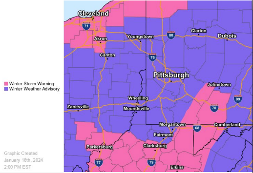 Headlines Issued for this Event |
Snow Reports
Public Information Statement
Spotter Reports
National Weather Service Pittsburgh PA
515 PM EST Sat Jan 20 2024
The following are unofficial observations taken during the past 47
hours for the storm that has been affecting our region. Appreciation
is extended to highway departments, cooperative observers, Skywarn
spotters and media for these reports. This summary also is available
on our home page at weather.gov/pittsburgh
**********STORM TOTAL SNOWFALL (AT LEAST 2.0 INCH)**********
LOCATION TOTAL TIME DATE COMMENTS
SNOWFALL
MEASURED
(inches)
| OHIO | ||||||
| ...Belmont County... | ||||||
| Blaine | 5 | 1018 | AM | 20-Jan | Public | |
| 1 N Morristown | 4.6 | 800 | AM | 20-Jan | Public | |
| ...Carroll County... | ||||||
| Leesville | 2 | 1150 | AM | 19-Jan | Public | |
| ...Columbiana County... | ||||||
| East Liverpool | 9 | 1059 | AM | 20-Jan | Public | |
| Salem | 8.8 | 834 | AM | 20-Jan | Public | |
| Lisbon | 8.5 | 717 | PM | 19-Jan | Public | |
| Calcutta | 8 | 700 | PM | 19-Jan | Public | |
| 2 SSW Leetonia | 8 | 600 | AM | 20-Jan | CoCoRaHS | |
| 2 SW Salem | 7.7 | 830 | PM | 19-Jan | Public | |
| 1 S Salem | 7.3 | 909 | PM | 19-Jan | Public | |
| N East Liverpool | 7 | 700 | AM | 20-Jan | Public | |
| 1 SSW La Croft | 7 | 749 | AM | 20-Jan | Public | |
| 1 N Salem | 6 | 600 | PM | 19-Jan | Public | |
| ENE Hanoverton | 5.8 | 400 | AM | 20-Jan | CoCoRaHS | |
| 4 N Wellsville | 4.8 | 800 | AM | 20-Jan | CoCoRaHS | |
| 1 N East Liverpool | 4.5 | 331 | PM | 19-Jan | Public | |
| Hillcrest | 4.2 | 500 | PM | 19-Jan | Public | |
| 2 N Wellsville | 4.2 | 500 | PM | 19-Jan | Public | |
| ...Guernsey County... | ||||||
| Claysville | 4 | 853 | PM | 19-Jan | Public | |
| 1 E Cambridge | 3.8 | 800 | AM | 20-Jan | CoCoRaHS | |
| Cambridge | 3 | 445 | PM | 19-Jan | Public | |
| 10 NE Cambridge | 2.5 | 612 | AM | 20-Jan | Estimated storm total. | |
| 3 SE Cambridge | 2.5 | 1051 | AM | 19-Jan | Trained Spotter | |
| E Quaker City | 2.5 | 115 | PM | 19-Jan | Trained Spotter | |
| 1 N Cambridge | 2.4 | 1201 | PM | 19-Jan | Public | |
| Byesville | 2 | 915 | AM | 19-Jan | Trained Spotter | |
| ...Harrison County... | ||||||
| 3 W Scio | 3.5 | 400 | AM | 20-Jan | Public | |
| ...Jefferson County... | ||||||
| Richmond | 6 | 830 | AM | 20-Jan | Public | |
| 1 NW Wintersville | 3.4 | 1030 | PM | 19-Jan | Trained Spotter | |
| Rayland | 2.8 | 717 | AM | 20-Jan | Public | |
| ...Noble County... | ||||||
| 3 W Mount Ephraim | 4 | 1000 | AM | 20-Jan | Public | |
| ...Tuscarawas County... | ||||||
| 1 S Dover | 4 | 900 | PM | 19-Jan | Public | |
| Dover | 4 | 900 | PM | 19-Jan | Public | |
| 2 SW Bolivar | 3.2 | 1115 | AM | 20-Jan | Public | |
| Roswell | 3 | 900 | AM | 20-Jan | Public | |
| Uhrichsville | 3 | 915 | AM | 20-Jan | Public | |
| NW Uhrichsville | 2.3 | 820 | AM | 20-Jan | Public | |
| PENNSYLVANIA | ||||||
| ...Allegheny County... | ||||||
| 1 S Fayetteville | 10 | 751 | AM | 20-Jan | Public | |
| 3 S Bethel Park | 8.2 | 700 | AM | 20-Jan | Public | |
| Jefferson Hills | 8.1 | 100 | PM | 19-Jan | Public | |
| 1 SW Bridgeville | 8 | 700 | AM | 20-Jan | CoCoRaHS | |
| Bethel Park | 8 | 834 | AM | 20-Jan | Public | |
| 1 NW Library Junctio | 8 | 914 | AM | 20-Jan | Public | |
| Bridgeville | 6.5 | 845 | PM | 19-Jan | Public | |
| Upper Saint Clair | 5.5 | 752 | AM | 20-Jan | Public | |
| Oakdale | 5 | 650 | PM | 19-Jan | Trained Spotter | |
| 2 WNW Imperial | 4.5 | 800 | AM | 20-Jan | CoCoRaHS | |
| 1 SE Avalon | 4.5 | 452 | PM | 19-Jan | Public | |
| 11 ESE Pittsburgh | 4.5 | 757 | PM | 19-Jan | Public | |
| 2 SE South Fayette | 4.3 | 700 | AM | 20-Jan | CoCoRaHS | |
| 1 N Imperial | 4.2 | 1159 | PM | 19-Jan | Public | |
| Dormont | 3.8 | 815 | PM | 19-Jan | Public | |
| 1 W McCandless | 3.5 | 1200 | PM | 20-Jan | Public | |
| 2 S Greenock | 3.5 | 1140 | AM | 20-Jan | Public | |
| 2 SW Penn Hills | 3.5 | 620 | PM | 19-Jan | Public | |
| 1 W West View | 3.3 | 530 | PM | 19-Jan | Trained Spotter | |
| NE Sharpsburg | 3 | 600 | PM | 19-Jan | Public | |
| Lawrenceville | 3 | 626 | PM | 19-Jan | NWS Employee | |
| Penn Hills | 3 | 821 | AM | 19-Jan | Public | |
| Castle Shannon | 3 | 334 | PM | 19-Jan | Trained Spotter | |
| 3 NW Jefferson Hills | 3 | 430 | PM | 19-Jan | Trained Spotter | |
| 1 N Carnot-Moon | 2.9 | 1200 | AM | 20-Jan | Official NWS Obs | |
| 4 NW Moon | 2.7 | 200 | PM | 19-Jan | Public | |
| Upper St. Clair | 2.7 | 130 | PM | 19-Jan | Trained Spotter | |
| 8 ENE Pittsburgh | 2.6 | 800 | AM | 20-Jan | CoCoRaHS | |
| South Side Flats | 2.5 | 430 | PM | 19-Jan | Public | |
| N Allegheny Center | 2.5 | 1115 | PM | 19-Jan | Public | |
| Brackenridge | 2.5 | 147 | PM | 19-Jan | Public | |
| 1 NNW Carnot-Moon | 2.3 | 400 | PM | 19-Jan | NWS Employee | |
| Springdale | 2.3 | 1147 | AM | 19-Jan | Trained Spotter | |
| ENE Harrison Townshi | 2.2 | 550 | AM | 20-Jan | CoCoRaHS | |
| 2 SW Pittsburgh | 2.2 | 200 | PM | 19-Jan | Public | |
| Crafton | 2.1 | 130 | PM | 19-Jan | Public | |
| Verona | 2 | 811 | AM | 19-Jan | Public | |
| Clinton | 2 | 1139 | AM | 19-Jan | Public | |
| Stanton Heights | 2 | 1115 | AM | 19-Jan | Public | |
| Baldwin | 2 | 138 | PM | 19-Jan | Public | |
| Mount Lebanon | 2 | 1140 | AM | 19-Jan | Public | |
| ...Armstrong County... | ||||||
| 3 NNW Shelocta | 2.3 | 700 | AM | 20-Jan | CoCoRaHS | |
| ...Beaver County... | ||||||
| Ohioville | 4 | 900 | AM | 20-Jan | Public | |
| Monaca | 3.5 | 501 | PM | 19-Jan | Public | |
| 6 W Beaver | 3 | 700 | AM | 20-Jan | CoCoRaHS | |
| 1 W Blackhawk | 3 | 400 | PM | 19-Jan | Public | |
| 2 N Aliquippa | 2.5 | 200 | PM | 19-Jan | Public | |
| Aliquippa | 2 | 423 | PM | 19-Jan | Public | |
| Economy | 2 | 700 | AM | 20-Jan | CoCoRaHS | |
| ...Butler County... | ||||||
| Cranberry | 4.5 | 930 | PM | 19-Jan | Public | |
| Clinton | 4 | 549 | PM | 19-Jan | NWS Employee | |
| Butler | 3.5 | 400 | PM | 19-Jan | Public | |
| Fernway | 3.5 | 1237 | PM | 19-Jan | Public | |
| West Sunbury | 3.1 | 1221 | PM | 19-Jan | Public | |
| 1 SW Meridian | 3 | 800 | AM | 20-Jan | CoCoRaHS | |
| Nixon | 2.2 | 159 | PM | 19-Jan | Public | |
| 2 NE Sarver | 2.2 | 1012 | AM | 20-Jan | CoCoRaHS | |
| 2 SW Saxonburg | 2 | 110 | PM | 19-Jan | Public | |
| Zelienople | 2 | 450 | PM | 19-Jan | Trained Spotter | |
| 1 S Mars | 2 | 1025 | AM | 19-Jan | Public | |
| ...Clarion County... | ||||||
| N Marble | 2.8 | 1000 | AM | 20-Jan | Trained Spotter | |
| ...Fayette County... | ||||||
| Farmington | 16 | 655 | AM | 20-Jan | Public | |
| 5 SE Champion | 14 | 527 | AM | 20-Jan | Public | |
| 2 NNW Point Breeze | 12 | 136 | PM | 20-Jan | Amateur Radio | |
| Chalkhill | 12 | 900 | AM | 20-Jan | Public | |
| 4 NW Ohiopyle | 11.3 | 800 | AM | 20-Jan | Trained Spotter | |
| 1 SSE Pleasant Hill | 10.5 | 200 | PM | 20-Jan | Public | |
| Connellsville | 8 | 800 | AM | 20-Jan | Public | |
| NW Rogerstown | 7.6 | 1020 | PM | 19-Jan | Public | |
| Indian Head | 7.5 | 1010 | PM | 19-Jan | Public | |
| Dawson | 7.5 | 853 | AM | 20-Jan | Public | |
| Uniontown | 7.2 | 833 | AM | 20-Jan | Public | |
| Dunbar | 7 | 900 | PM | 19-Jan | Public | |
| NE Connellsville | 6.8 | 1100 | PM | 19-Jan | Public | |
| 1 NW Hopwood | 3.1 | 100 | AM | 19-Jan | Trained Spotter | |
| Point Marion | 2.5 | 1053 | AM | 19-Jan | Co-Op Observer | |
| 2 NNE Uniontown | 2.5 | 448 | PM | 19-Jan | CoCoRaHS | |
| Allison | 2 | 845 | AM | 19-Jan | Public | |
| 1 E Belle Vernon | 2 | 1213 | PM | 19-Jan | Trained Spotter | |
| ...Forest County... | ||||||
| 9 NE Marienville | 7.5 | 1100 | AM | 20-Jan | Public | |
| ...Greene County... | ||||||
| Waynesburg | 7 | 900 | AM | 20-Jan | Public | |
| Oak Forest | 5 | 930 | AM | 20-Jan | Public | |
| Greensboro | 3 | 1020 | AM | 19-Jan | Public | |
| 1 SW Point Marion | 2.8 | 600 | AM | 20-Jan | Co-Op Observer | |
| 1 E Waynesburg | 2.4 | 700 | AM | 20-Jan | Co-Op Observer | |
| ...Indiana County... | ||||||
| Indiana | 4 | 1234 | PM | 19-Jan | Public | |
| Shelocta | 4 | 700 | AM | 20-Jan | Public | |
| ...Jefferson County... | ||||||
| Reynoldsville | 4 | 1111 | AM | 19-Jan | Public | |
| NNE Corsica | 2 | 600 | PM | 19-Jan | CoCoRaHS | |
| ...Lawrence County... | ||||||
| 1 E New Castle North | 3.4 | 1030 | AM | 19-Jan | Public | |
| Enon Valley | 2.4 | 600 | PM | 19-Jan | Public | |
| 4 S Volant | 2 | 945 | PM | 19-Jan | Public | |
| Chewton | 2 | 920 | AM | 19-Jan | Public | |
| ...Mercer County... | ||||||
| Greenville | 3.8 | 415 | PM | 20-Jan | Trained Spotter | |
| ...Venango County... | ||||||
| 1 E Cooperstown | 4.5 | 830 | AM | 20-Jan | CoCoRaHS | |
| 1 NNE Seneca | 4 | 700 | AM | 20-Jan | CoCoRaHS | |
| NW Reno | 3.9 | 600 | AM | 20-Jan | CoCoRaHS | |
| 1 SSW Franklin | 2.7 | 600 | AM | 20-Jan | CoCoRaHS | |
| 1 E Franklin | 2 | 800 | AM | 20-Jan | Co-Op Observer | |
| ...Washington County... | ||||||
| 1 E Cecil | 10.5 | 630 | AM | 20-Jan | Public | |
| McDonald | 10 | 200 | AM | 20-Jan | Public | |
| McMurray | 8.5 | 940 | PM | 19-Jan | Public | |
| Finleyville | 8 | 940 | PM | 19-Jan | Public | |
| New Eagle | 7.5 | 115 | PM | 20-Jan | Public | |
| Donora | 7 | 700 | AM | 19-Jan | Public | |
| Washington | 6.5 | 830 | AM | 20-Jan | Public | |
| Canonsburg | 6.5 | 730 | AM | 20-Jan | Public | |
| Venetia | 6.2 | 930 | PM | 19-Jan | Trained Spotter | |
| SE Canonsburg | 6 | 700 | AM | 20-Jan | Public | |
| Gastonville | 6 | 235 | PM | 20-Jan | Public | |
| California | 5.5 | 1128 | PM | 19-Jan | Trained Spotter | |
| Charleroi | 5.5 | 1000 | PM | 19-Jan | Trained Spotter | |
| 3 N Hickory | 5.4 | 930 | PM | 19-Jan | Trained Spotter | |
| Cecil | 5 | 512 | PM | 19-Jan | Public | |
| Bower Hill | 4.7 | 500 | PM | 19-Jan | Trained Spotter | |
| 1 WNW Venetia | 4.5 | 830 | AM | 20-Jan | CoCoRaHS | |
| Bulger | 4.5 | 659 | PM | 19-Jan | Public | |
| Granville | 4 | 113 | PM | 20-Jan | Public | |
| Wylandville | 4 | 500 | AM | 20-Jan | Public | |
| SSE Dunlevy | 3.8 | 800 | AM | 20-Jan | CoCoRaHS | |
| 5 E Avella | 3.2 | 735 | AM | 20-Jan | CoCoRaHS | |
| 4 NW Canonsburg | 3.1 | 700 | AM | 20-Jan | CoCoRaHS | |
| Stockdale | 2.5 | 116 | PM | 19-Jan | Public | |
| ...Westmoreland County.. | . | |||||
| North Belle Vernon | 8 | 500 | PM | 20-Jan | Public | |
| Monessen | 6 | 830 | PM | 19-Jan | Public | |
| West Newton | 6 | 835 | AM | 20-Jan | Public | |
| Pricedale | 6 | 900 | PM | 19-Jan | Public | |
| 3 WSW Smithton | 5.3 | 633 | AM | 20-Jan | CoCoRaHS | |
| 3 ESE Smithton | 4 | 800 | AM | 20-Jan | CoCoRaHS | |
| Youngwood | 3.5 | 1110 | AM | 20-Jan | Public | |
| Trafford | 3.5 | 754 | PM | 19-Jan | Public | |
| 3 S Latrobe | 3 | 1215 | PM | 19-Jan | Public | |
| New Stanton | 3 | 337 | PM | 19-Jan | Public | |
| 5 NW New Stanton | 3 | 100 | AM | 19-Jan | Public | |
| Murrysville | 2.5 | 238 | PM | 19-Jan | Public | |
| Irwin | 2.4 | 541 | PM | 19-Jan | Public | |
| Lower Burrell | 2.4 | 245 | PM | 19-Jan | Trained Spotter | |
| 1 SW New Alexandria | 2.3 | 700 | PM | 19-Jan | Public | |
| Manor | 2.2 | 412 | PM | 19-Jan | Public | |
| 1 WSW Monessen | 2 | 853 | AM | 19-Jan | Snowfall since 1 AM | |
| 1 SW New Stanton | 2 | 745 | AM | 20-Jan | Co-Op Observer | |
| 1 S Irwin | 2 | 700 | AM | 20-Jan | CoCoRaHS | |
| Ligonier | 2 | 943 | AM | 19-Jan | Utility Company | |
| WEST VIRGINIA | ||||||
| ...Brooke County... | ||||||
| 5 E Wellsburg | 5.2 | 830 | AM | 20-Jan | Public | |
| Colliers | 4.5 | 400 | PM | 19-Jan | Public | |
| ...Hancock County... | ||||||
| 3 SW Chester | 5.1 | 530 | PM | 19-Jan | Public | |
| New Manchester | 3.5 | 1030 | PM | 19-Jan | Public | |
| NW Marland Heights | 2.8 | 1112 | AM | 19-Jan | Public | |
| Weirton | 2.5 | 1000 | AM | 19-Jan | Public | |
| ...Marion County... | ||||||
| 2 NNE Grant Town | 6 | 900 | AM | 20-Jan | Public | |
| 3 E Colfax | 5.3 | 900 | AM | 20-Jan | Public | |
| Farmington | 5 | 947 | AM | 19-Jan | Public | |
| Fairmont | 4.5 | 912 | AM | 20-Jan | Public | |
| 1 SE Katy | 4 | 350 | PM | 19-Jan | Trained Spotter | |
| 2 N Rivesville | 4 | 600 | AM | 20-Jan | CoCoRaHS | |
| 3 ENE Fairmont | 3.5 | 700 | AM | 20-Jan | CoCoRaHS | |
| Meadowdale | 3 | 800 | PM | 19-Jan | Public | |
| 1 SSE Fairmont | 2.5 | 1200 | AM | 20-Jan | Co-Op Observer | |
| ...Marshall County... | ||||||
| Dallas | 7 | 930 | AM | 20-Jan | Public | |
| Glendale | 3 | 745 | PM | 19-Jan | Amateur Radio | |
| 4 SSW Moundsville | 3 | 700 | AM | 20-Jan | CoCoRaHS | |
| ...Monongalia County... | ||||||
| Woodburn | 6 | 330 | PM | 20-Jan | Amateur Radio | |
| 2 NNE New Hill | 5.5 | 234 | PM | 20-Jan | Public | |
| Suncrest | 5 | 843 | AM | 20-Jan | Amateur Radio | |
| 8 SE Morgantown | 4.5 | 745 | PM | 19-Jan | Amateur Radio | |
| Morgantown | 4.5 | 842 | AM | 20-Jan | Storm total snow. | |
| Granville | 4 | 745 | PM | 19-Jan | Amateur Radio | |
| 5 E Morgantown | 3.8 | 745 | PM | 19-Jan | Amateur Radio | |
| 6 S Morgantown | 3.5 | 745 | PM | 19-Jan | Amateur Radio | |
| 6 SW Morgantown | 3.5 | 809 | AM | 20-Jan | Trained Spotter | |
| 2 SE Morgantown | 3 | 745 | PM | 19-Jan | Amateur Radio | |
| Star City | 2.8 | 959 | AM | 19-Jan | Trained Spotter | |
| 5 S Morgantown | 2.8 | 1043 | AM | 19-Jan | Amateur Radio | |
| 2 E Morgantown | 2 | 826 | AM | 19-Jan | Trained Spotter | |
| ...Ohio County... | ||||||
| Triadelphia | 3.2 | 207 | PM | 19-Jan | Broadcast Media | |
| 4 NNE Valley Grove | 3 | 700 | AM | 20-Jan | CoCoRaHS | |
| Wheeling | 2.5 | 423 | PM | 19-Jan | Trained Spotter | |
| ...Preston County... | ||||||
| 1 NW Pisgah | 17 | 848 | AM | 20-Jan | Public | |
| Laurel Run | 16.5 | 900 | AM | 20-Jan | Public | |
| Amblersburg | 16 | 152 | PM | 20-Jan | Still snowing | |
| Tunnelton | 16 | 1030 | AM | 20-Jan | Public | |
| Masontown | 14 | 505 | PM | 20-Jan | Still snowing | |
| Rodemer | 14 | 509 | AM | 20-Jan | Dept of Highways | |
| Cuzzart | 12 | 842 | AM | 20-Jan | Amateur Radio | |
| Reedsville | 12 | 841 | AM | 20-Jan | Amateur Radio | |
| 5 NNE Terra Alta | 11.5 | 800 | AM | 20-Jan | CoCoRaHS | |
| E Terra Alta | 11.2 | 700 | AM | 20-Jan | CoCoRaHS | |
| 3 S Bruceton Mills | 11.2 | 700 | AM | 20-Jan | Public | |
| Mount Vernon | 10 | 205 | PM | 19-Jan | Public | |
| Albright | 9 | 1100 | AM | 20-Jan | Public | |
| 1 SSE Albright | 8 | 459 | AM | 20-Jan | Dept of Highways | |
| Bruceton Mills | 8 | 759 | PM | 19-Jan | Public | |
| 7 N Thomas | 7 | 700 | AM | 20-Jan | CoCoRaHS | |
| Independence | 6.5 | 436 | PM | 19-Jan | Public | |
| Terra Alta | 4 | 1140 | AM | 19-Jan | Trained Spotter | |
| ...Tucker County... | ||||||
| 1 SSW Cortland | 23.5 | 1051 | AM | 20-Jan | Public | |
| 7 SSE Canaan Hgts | 19 | 850 | AM | 20-Jan | Storm Total. | |
| Parsons | 14 | 810 | AM | 20-Jan | Emergency Mngr | |
| Hambleton | 14 | 745 | PM | 19-Jan | Public | |
| 3 S Canaan Hgts | 13.6 | 900 | AM | 20-Jan | Co-Op Observer | |
| 7 S Davis | 12 | 730 | AM | 20-Jan | Storm Total. | |
| Davis | 9.5 | 700 | AM | 20-Jan | Co-Op Observer | |
| ...Wetzel County... | ||||||
| Folsom | 9 | 913 | AM | 20-Jan | Public | |
| 7 E New Martinsville | 5.8 | 800 | AM | 20-Jan | CoCoRaHS | |
| 2 N Glover Gap | 5 | 650 | AM | 20-Jan | Co-Op Observer | |
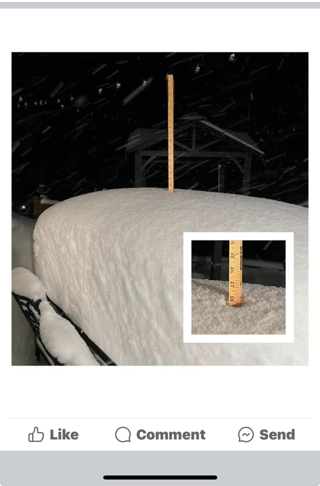
Snowfall Total Map
Snowfall Totals in this map include the synoptic snowfall on Thursday and also the upslope snow shower portion on Friday and Saturday.
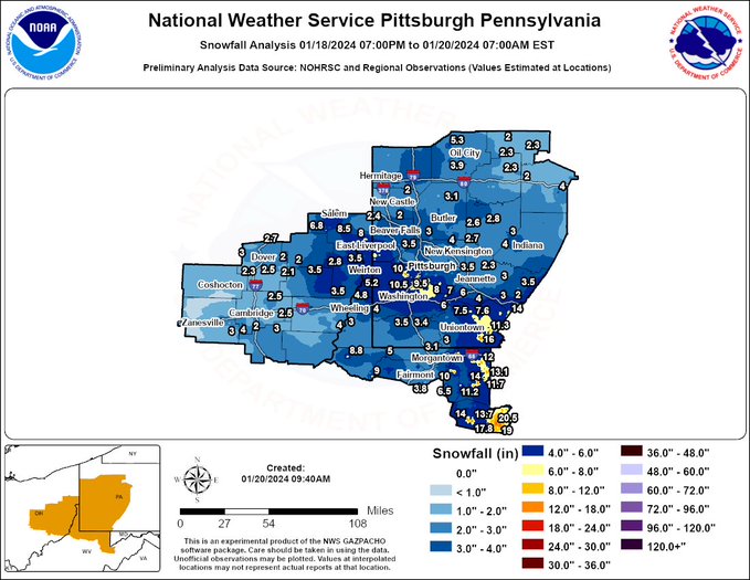
Snowfall Total Map
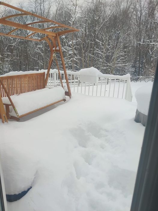
Photos
 |
 |
 |
 |
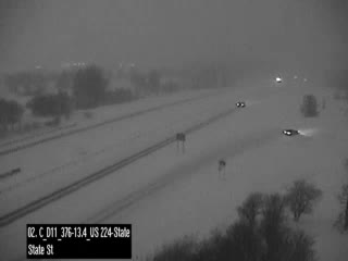
| Snow Covered Roads on 376 Credit: PA 511 |
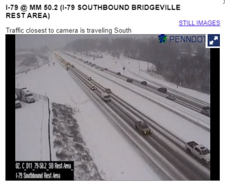
Snow Covered Roads on I-79 Credit: PA 511 |
Cooper's Rock WV Credit: Susan Boyer Teeple |
Canaan Valley WV Credit: SBeth Schwartz |
Radar
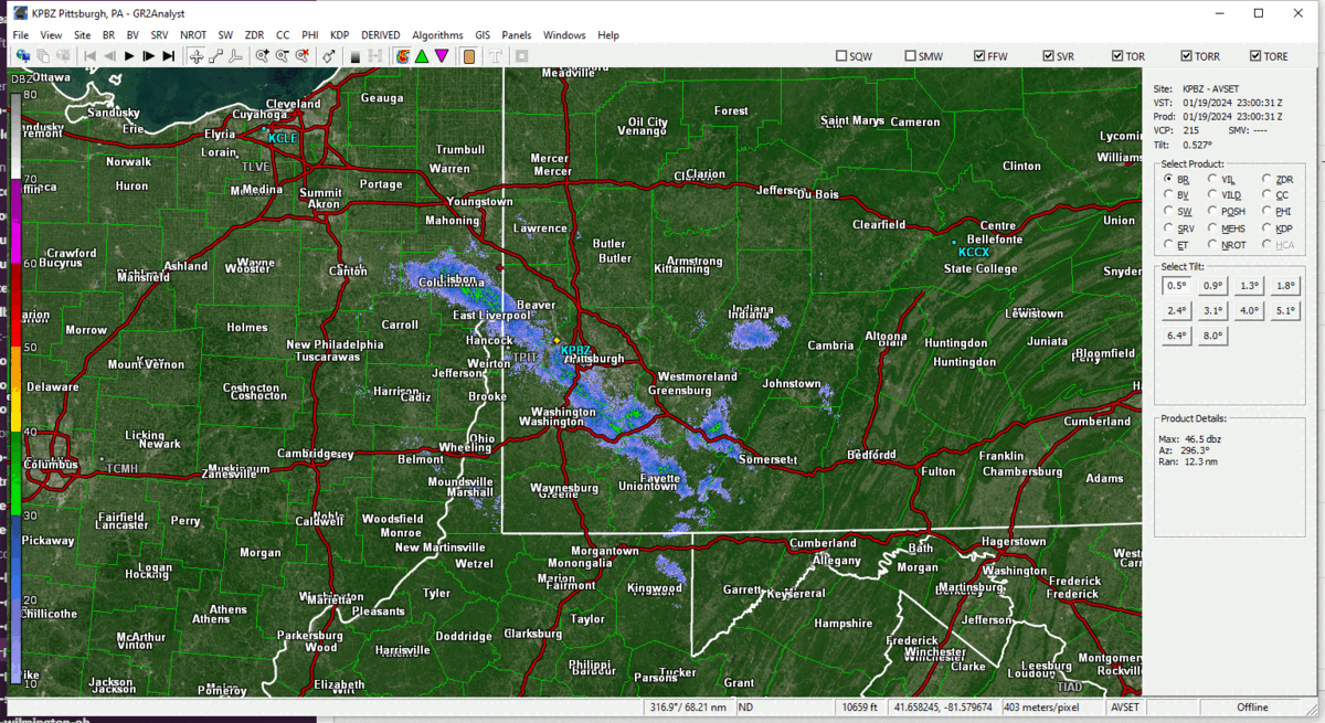
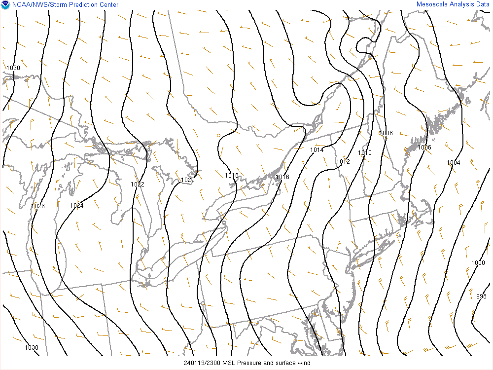
During the upslope portion of the event, a strong narrow band of heavy snow showers formed right along the southwest border of Allegheny and Washington Counties and persisted there from 20Z on the 19th through 03Z on the 20th. This band, at it's max strength, was producing up to 2 inches per hour snowfall rates at times. It resulted in some snowfall amounts in PA counties such as Allegheny, Washington, Fayette, and Westmoreland well above expected totals. Columbiana County in Ohio also received heavy snowfall from this band. The surface mesoscale analysis at 22Z and 23Z indicate that the surface winds show that indeed there was a double fetch in place off both Lake Huron and Lake Erie. Just like a situation that you would see in Buffalo, NY, this resulted in heavy snowfall in one area under the band, but 10 miles to the northeast or southwest, little to no snowfall.
 |
 |
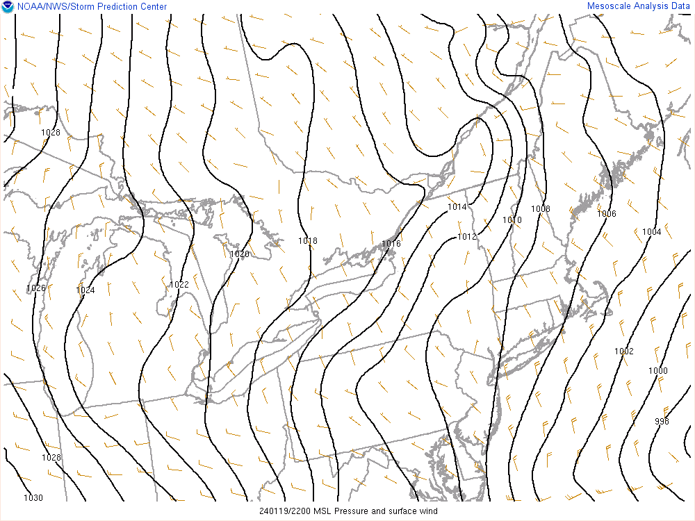 |
| Caption | SPC SFC Wind and MSLP 1/19/24 23Z | SPC SFC Wind and MSLP 1/19/24 22Z |
Environment/Surface Maps/Upper Air Maps
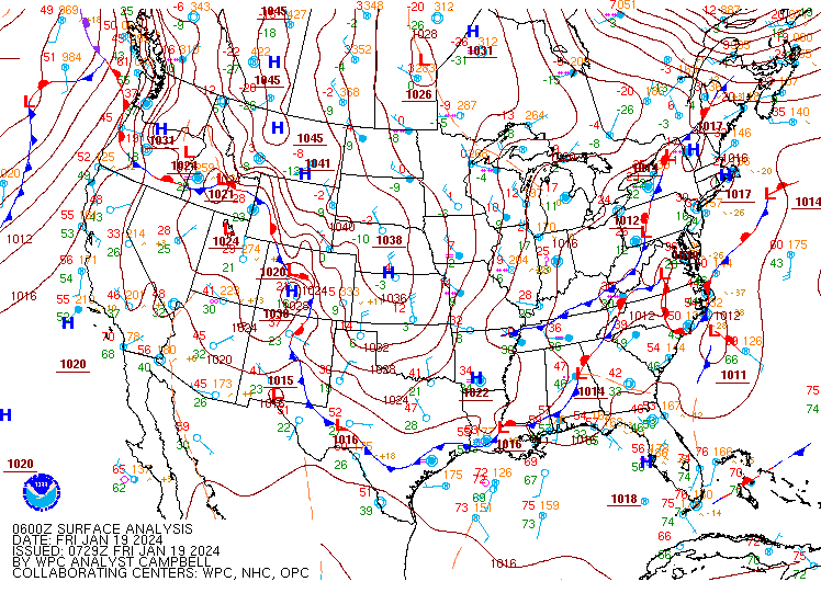
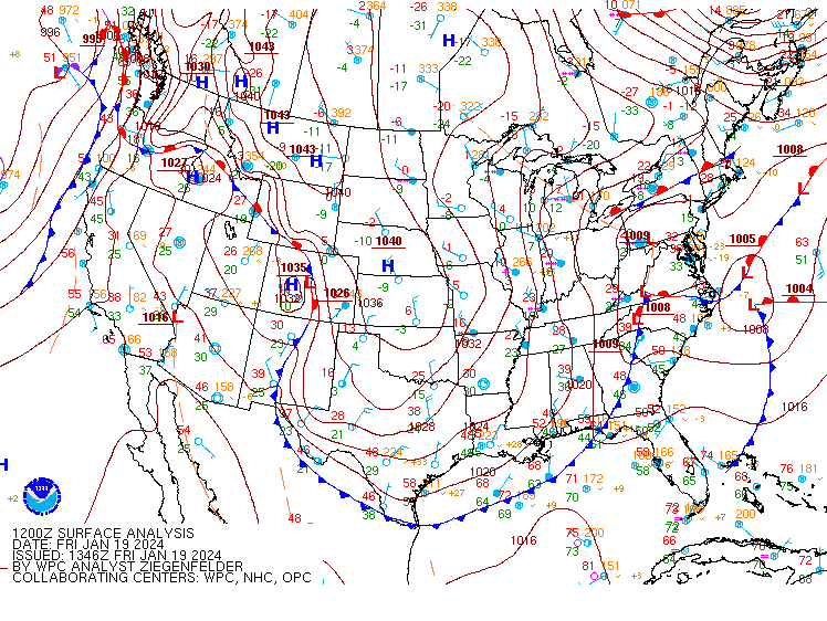
Surface Maps from WPC.
 |
 |
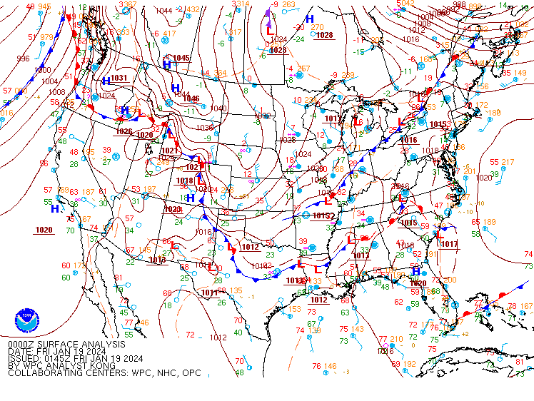 |
| 1/18/24 12Z SFC | 1/18/24 18Z SFC | 1/19/24 00Z SFC |
 |
 |
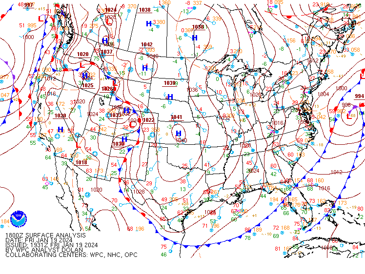 |
| 1/19/24 06Z SFC | 1/19/24 12Z SFC | 1/19/24 18Z SFC |
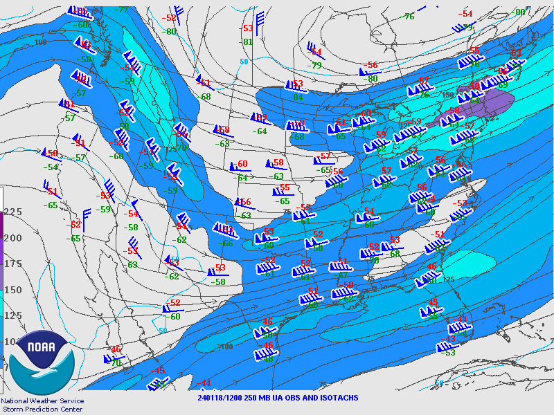
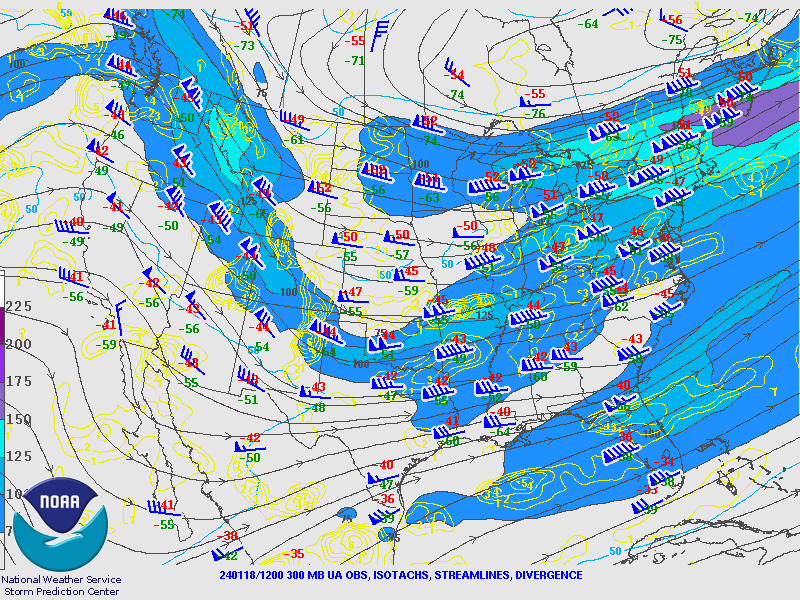
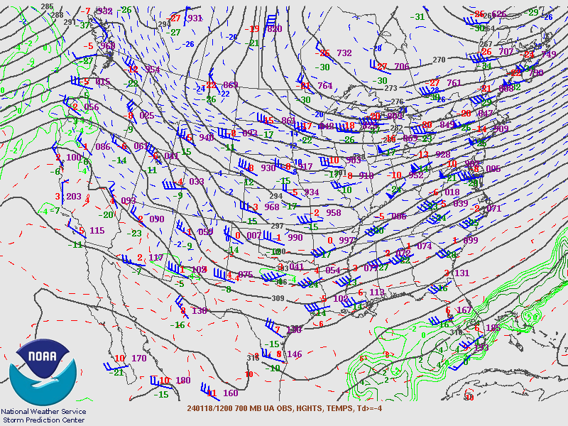
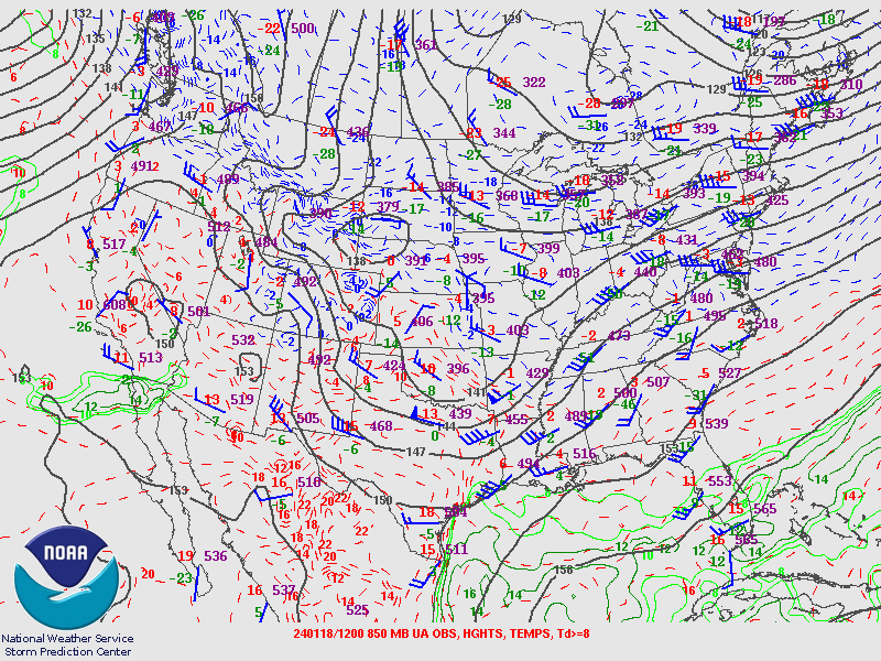
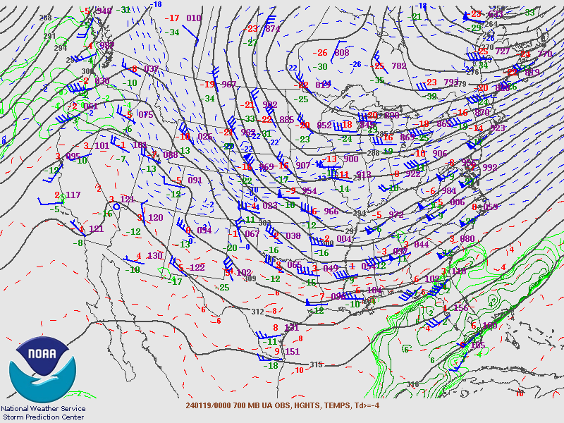
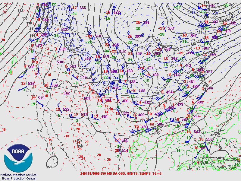
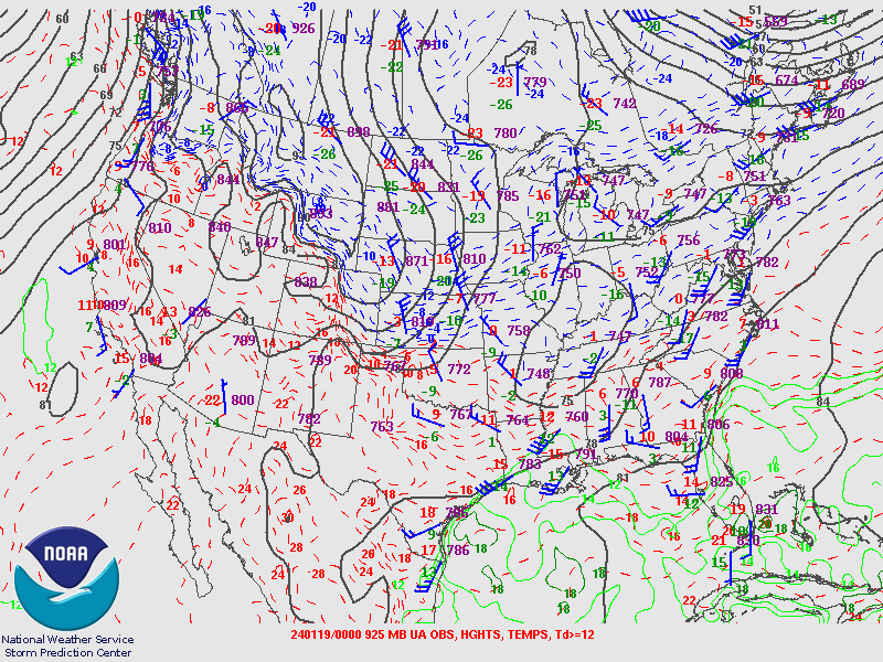
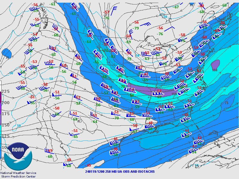
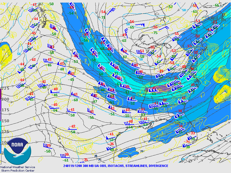
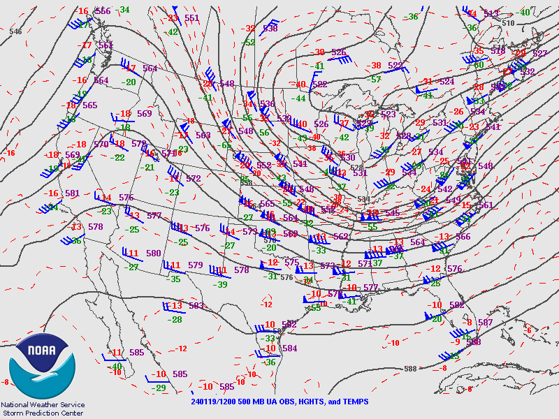
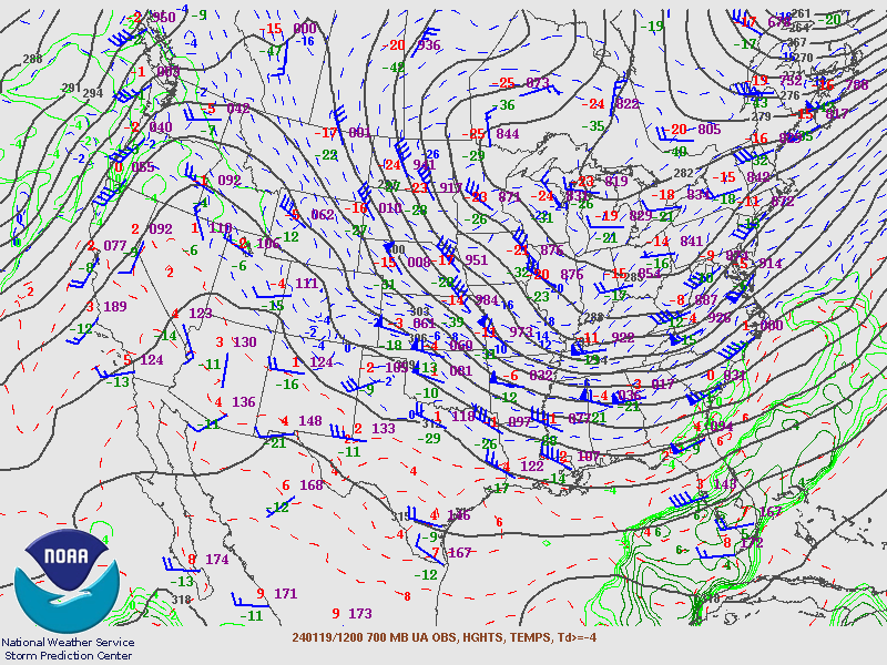
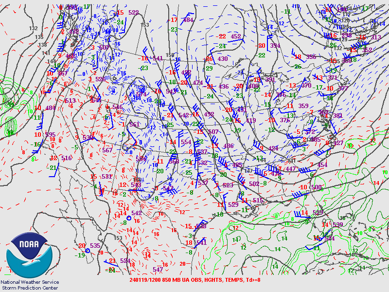
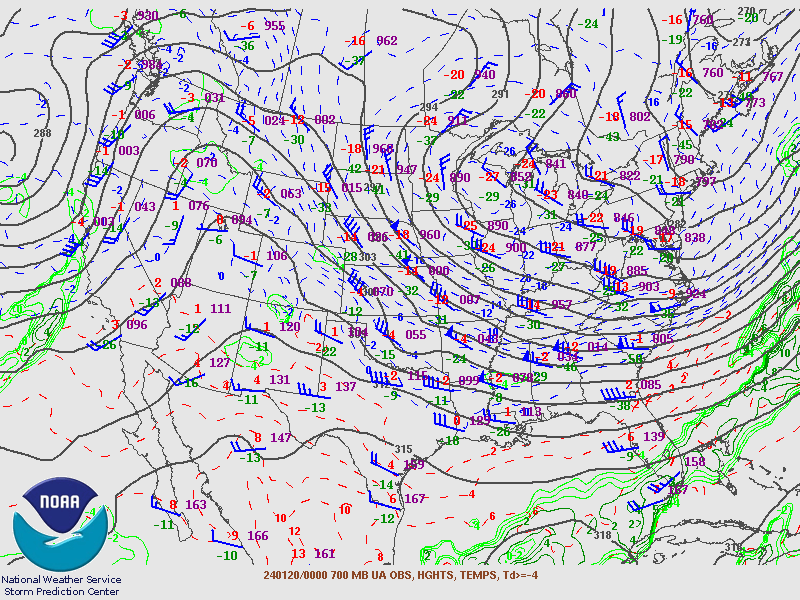
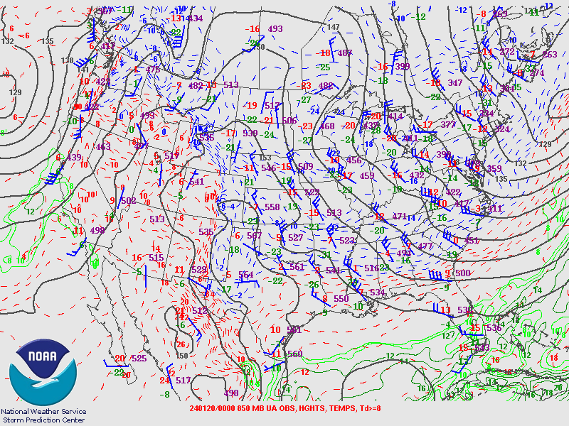
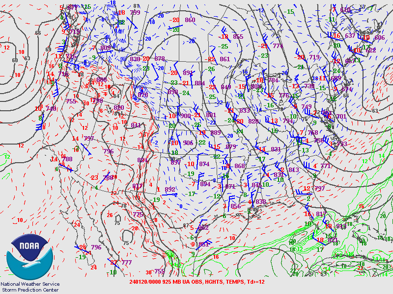
Upper Air Maps from SPC.
1/18/24 12Z Upper Air Maps
 |
 |
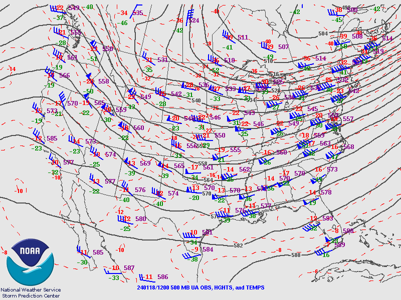 |
| 250MB | 300MB | 500MB |
 |
 |
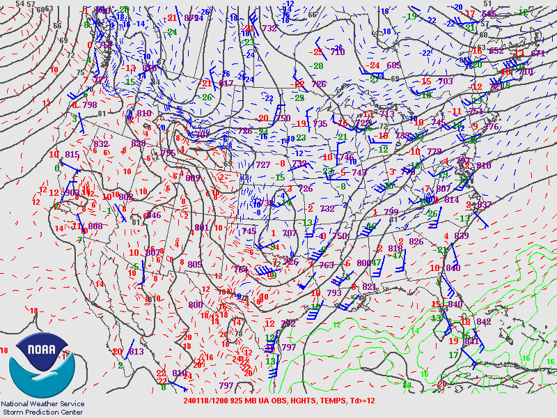 |
| 700MB | 850MB | 925MB |
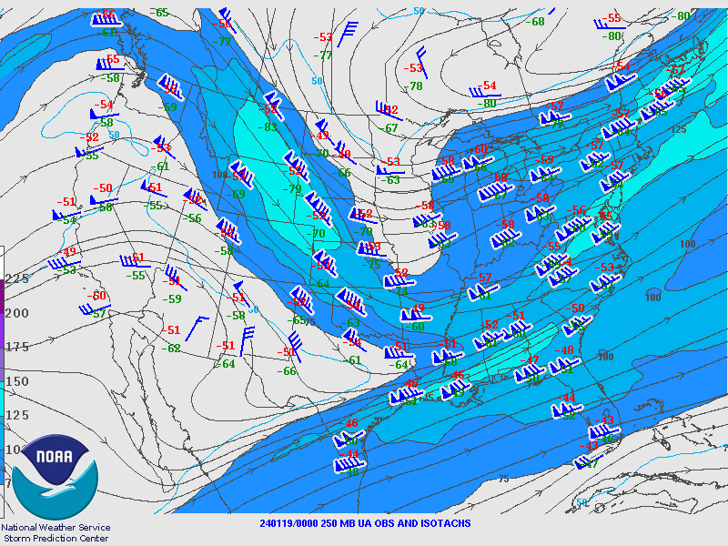
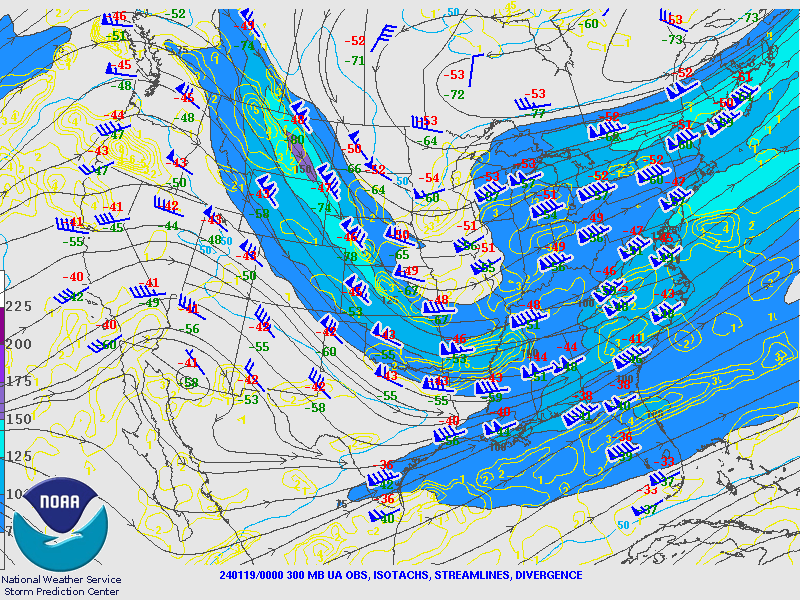
1/19/24 00Z Upper Air Maps
 |
 |
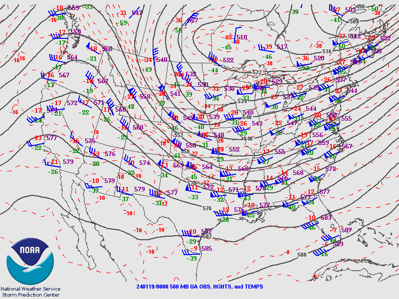 |
| 250MB | 300MB | 500MB |
 |
 |
 |
| 700MB | 850MB | 925MB |
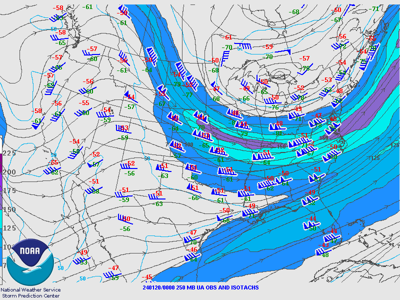
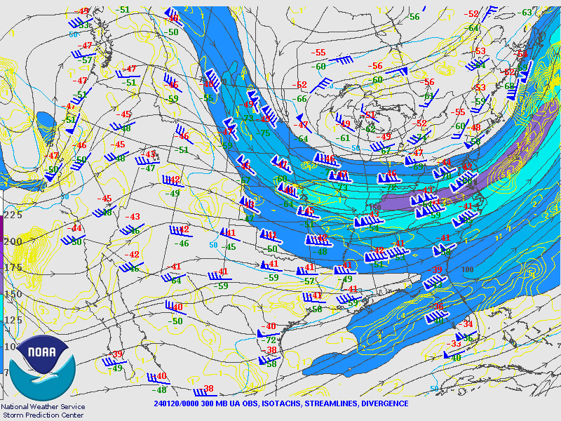
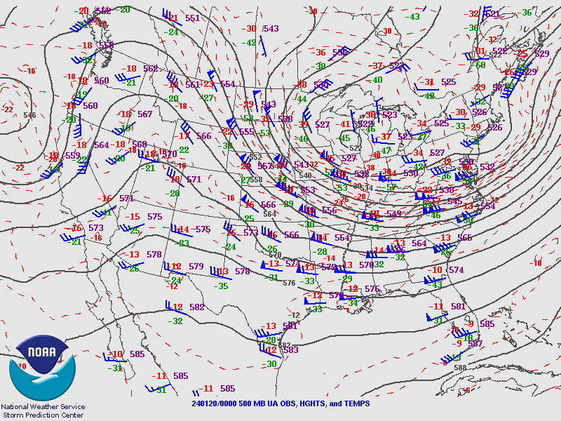
1/19/24 12Z Upper Air Maps
 |
 |
 |
| 250MB | 300MB | 500MB |
 |
 |
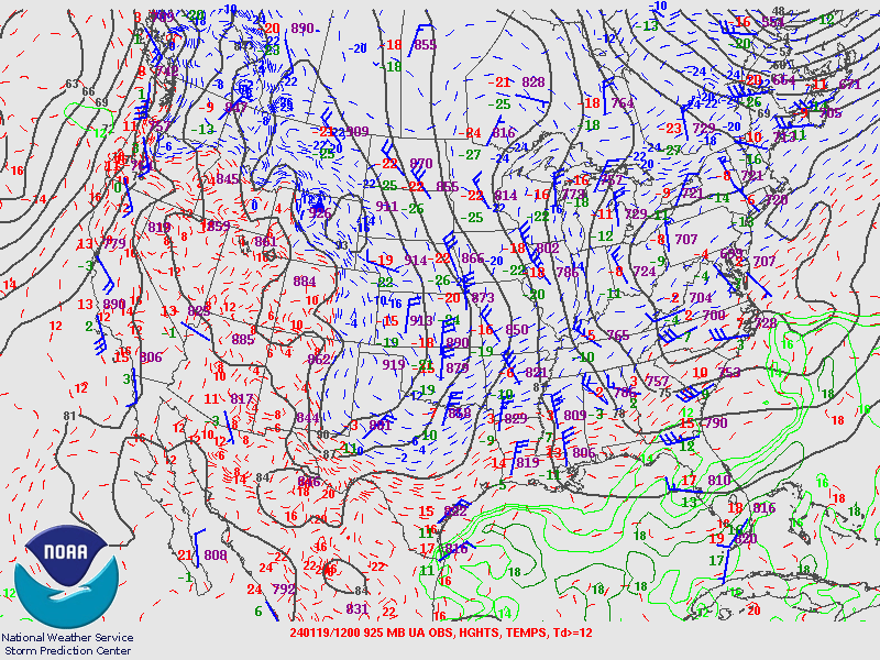 |
| 700MB | 850MB | 925MB |
1/20/24 00Z Upper Air Maps
 |
 |
 |
| 250MB | 300MB | 500MB |
 |
 |
 |
| 700MB | 850MB | 925MB |
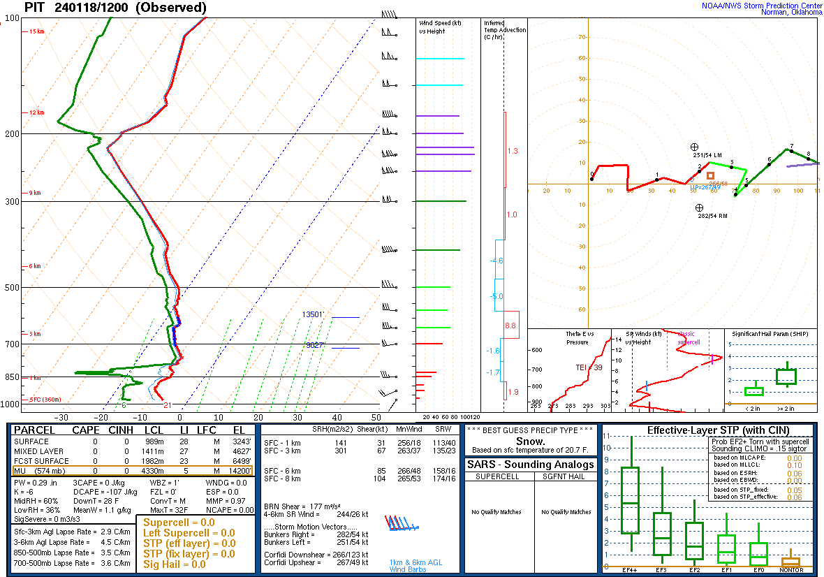
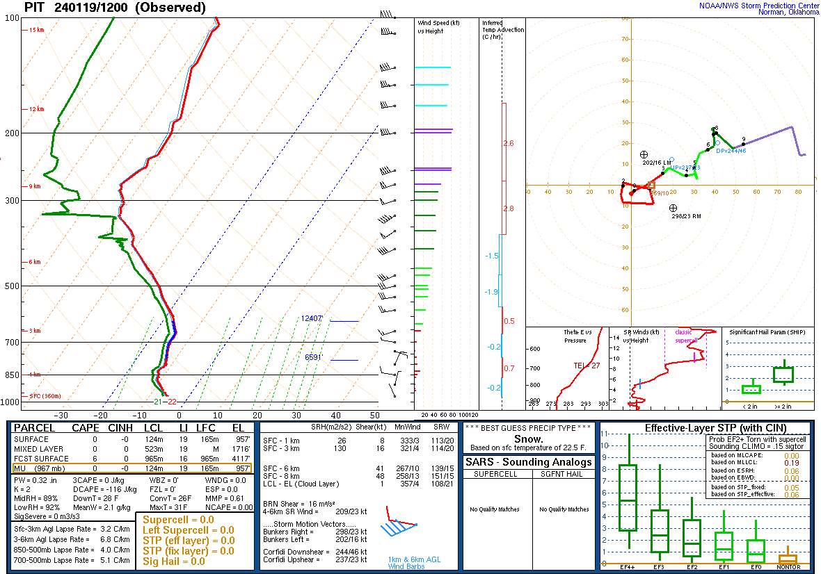
Skew-T's from PIT.
 |
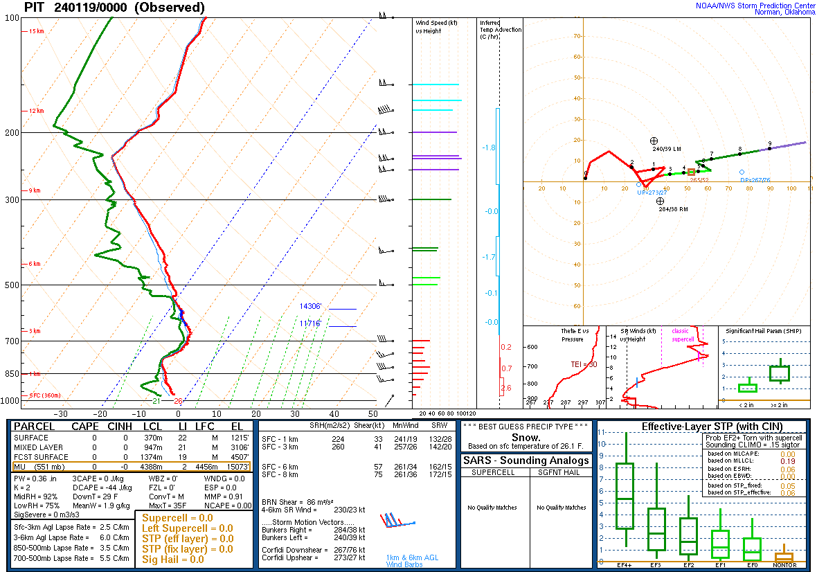 |
| Pittsburgh 1/18/24 12Z Sounding | Pittsburgh 1/19/24 00Z Sounding |
 |
 |
| Pittsburgh 1/19/24 12Z Sounding | Pittsburgh 1/20/24 00Z Sounding |
 |
Media use of NWS Web News Stories is encouraged! Please acknowledge the NWS as the source of any news information accessed from this site. |
|

