Overview
|
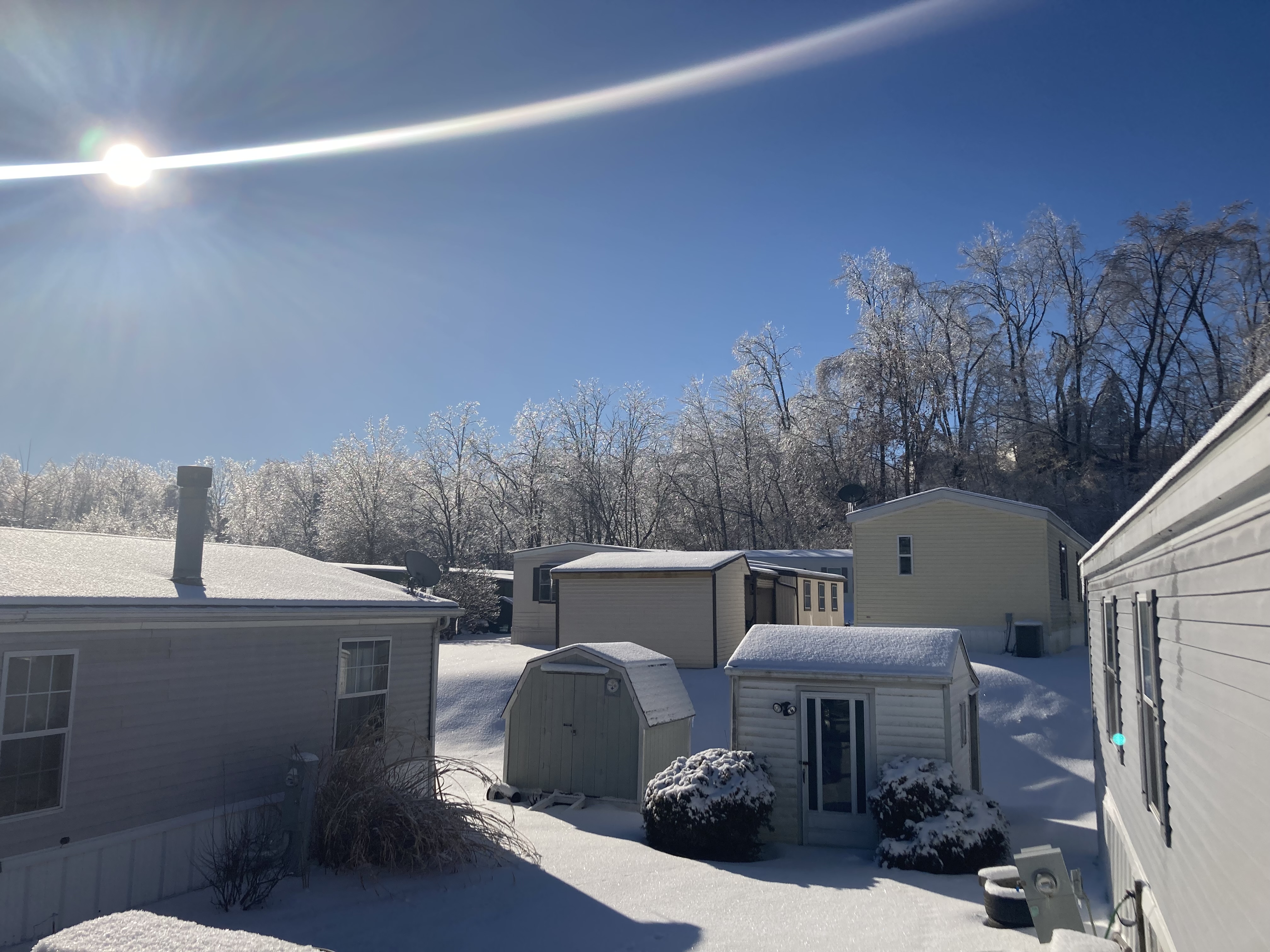
On the morning of Wednesday, a stout high pressure was firmly in place over the Canadian Maritimes with a strong ridge axis extending down the East Coast. Over the central United States a strong upper level trough developed as the Polar Front Jet dove south into the Lower MS Valley. A strong surface cold front developed and strengthened as it slowly made an eastward progression over the next 48-72 hours. Strong southerly flow ahead of the front allowed for heavy rainfall, a wintry mix, and heavy snowfall to be reported all the way from Texas northeast to Maine. This setup brought ample moisture northward into the Upper Ohio Valley Region. A moderate to heavy rainfall developed over the region by Wednesday night. With the area already under 3 to 6 inch snowpack (more in the mountains), and ice well formed along the rivers and creeks in the north from arctic air entrenched over the region for an extended period, a flood threat was evident in addition to the dangerous amounts of freezing rain and snow expected. Moderate to heavy rain continued through the day on Thursday as the front slowly progressed east as rain changed over to freezing rain. The mentioned ridge over the East Coast impeded the eastward progression as the front did stall at times keeping freezing rain over the same locations for a dangerous extended period of time in some instances. This also meant that heavy rainfall over the same locations for a period of time as well. This indeed led to the flooding of low lying areas and along creeks and streams. The ice build up along rivers led to ice jams in some locations causing flooding in these locations as well. One of these instances was at Fish's Creek in Marshall County WV. Another event occurred along the Muskingum River and also along the Conquessening River. The prolonged period of freezing rain led to heavy ice accretion on trees causing them to fall over powerlines. Power outages to homes and businesses climbed into the tens of thousands in Pennsylvania, West Virginia, and especially into Ohio where the heaviest amount of freezing rain occurred. The northern Pennsylvania counties along I-80 changed over to snow first where some locations received 6 to 10 inches. By Friday afternoon, a strong push of arctic air from the northwest allowed the front to finally push through the area with snow showers lingering across the Upper OH Valley on Friday evening before finally coming to an end. In addition, the mentioned push of arctic air brought temperatures into the single digits for the weekend keeping the snow and ice around for a longer period of time. The multifaceted threats of this winter event led to a wide range of impacts and some broken daily rainfall records at several locations. |
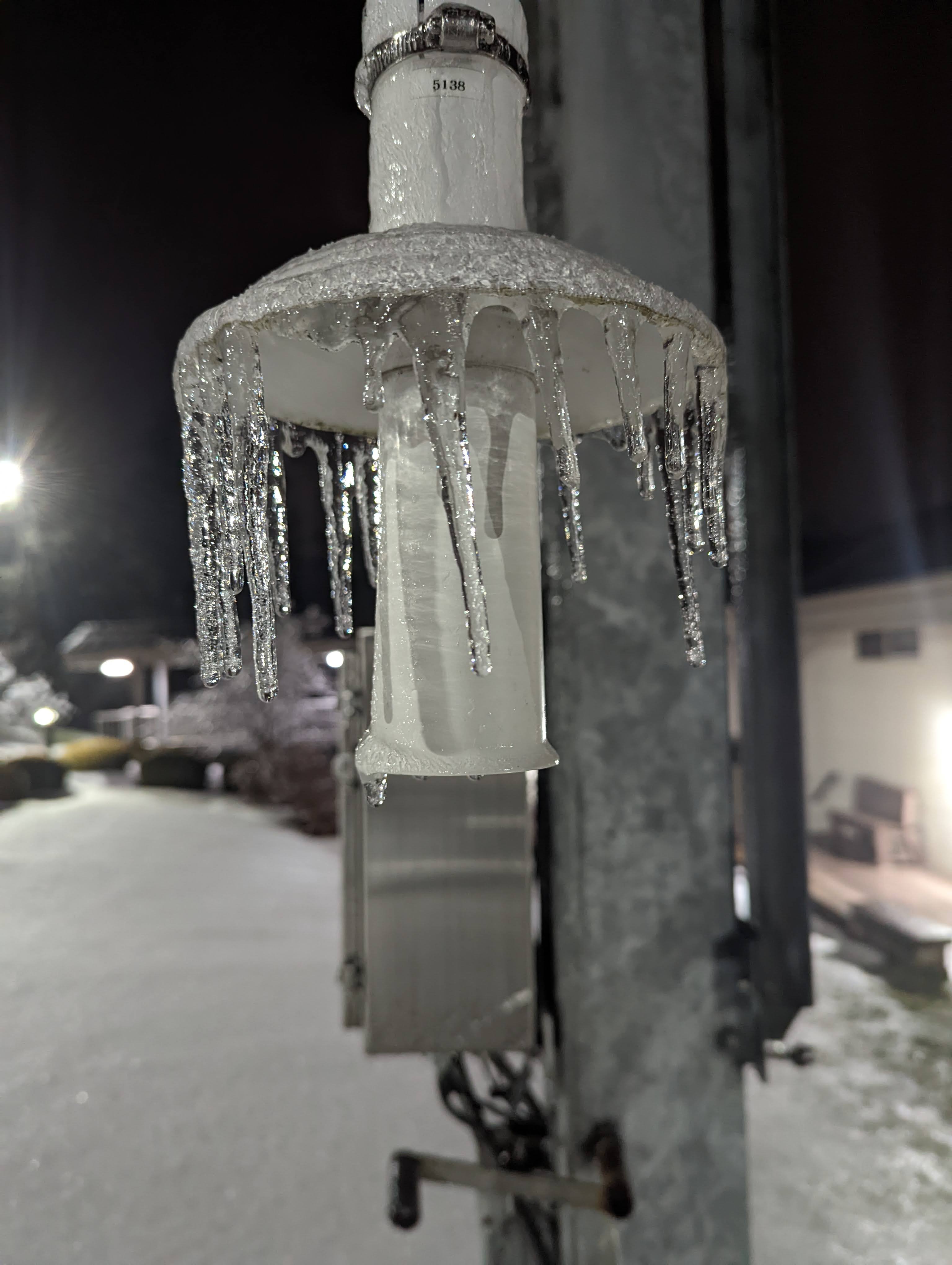
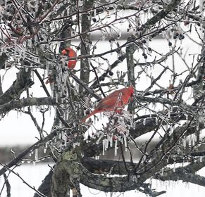
Credit: Jared Rackley |
Snow/Ice Storm Totals
********************STORM TOTAL SNOWFALL********************

LOCATION                TOTAL      TIME/DATE  COMMENTS
                     SNOWFALL       MEASURED
                     (inches)

OHIO

...Belmont County...
  2 N Morristown          1.5  1030 AM  2/04  Public
  Blaine                  1.0   433 AM  2/04  Trained Spotter

...Carroll County...
  1 SE Carrollton         5.0   645 PM  2/04  Facebook
  Mechanicstown           2.5   618 PM  2/04  Facebook
  Leesville               1.5   923 AM  2/04  Trained Spotter

...Columbiana County...
  ENE Hanoverton          6.4   400 AM  2/04  CoCoRaHS
  East Liverpool          3.5   650 PM  2/04  Facebook
  4 N Wellsville          2.5   930 AM  2/04  Broadcast Media
  Leetonia                2.5   400 AM  2/04  Facebook

...Coshocton County...
  Coshocton               2.0  1035 PM  2/03  Trained Spotter
  2 NNE Fresno            1.3   800 AM  2/04  CoCoRaHS

...Guernsey County...
  3 NE Cambridge          1.0   700 AM  2/04  CoCoRaHS
  Cambridge               0.5   600 PM  2/03  Public

...Jefferson County...
  2 WNW Steubenville      2.0   800 AM  2/04  CoCoRaHS
  1 WSW Mount Pleasant    1.5   800 AM  2/04  CoCoRaHS
  Steubenville            0.7   103 AM  2/04  Broadcast Media

...Muskingum County...
  1 N Zanesville          3.0  1129 PM  2/03  Public

...Tuscarawas County...
  New Philadelphia        6.0  1112 AM  2/04  Facebook
  2 S Stone Creek         6.0  1000 AM  2/04  Public
  Dover                   6.0   740 AM  2/04  Facebook
  WNW Carmichaels         5.0   700 AM  2/04  CoCoRaHS
  5 WNW Dover             4.3   700 AM  2/04  CoCoRaHS
  1 NW Dennison           2.6   700 AM  2/04  Co-Op Observer
  1 N Uhrichsville        1.0   700 AM  2/04  CoCoRaHS

PENNSYLVANIA

...Allegheny County...
  2 SSE Plum              2.8   256 PM  2/04  CoCoRaHS
  White Oak               2.5   502 PM  2/04  Facebook
  Ross Township           2.0   445 PM  2/04  Facebook
  Plum                    1.5   404 PM  2/04  Twitter
  2 S McCandless Towns    1.2   700 AM  2/04  CoCoRaHS
  6 E Pittsburgh          1.1   800 AM  2/04  CoCoRaHS
  2 NE Moon               1.1   700 AM  2/04  Co-Op Observer
  1 NE Gibsonia           1.0   530 AM  2/04  CoCoRaHS
  1 W Edgeworth           1.0   600 AM  2/04  Co-Op Observer
  2 WNW Coraopolis        1.0   800 AM  2/04  CoCoRaHS
  2 WNW Imperial          0.9   800 AM  2/04  CoCoRaHS
  4 NE Pittsburgh         0.7   816 AM  2/04  CoCoRaHS
  1 SW Bridgeville        0.6   700 AM  2/04  CoCoRaHS
  8 ENE Pittsburgh        0.5   800 AM  2/04  CoCoRaHS
  2 SE South Fayette      0.5   700 AM  2/04  CoCoRaHS
  NW Aspinwall            0.3   700 AM  2/04  CoCoRaHS
  Braddock Lock And Da    0.1   600 AM  2/04  Co-Op Observer
  Upper St. Clair           T   700 AM  2/04  Public

...Armstrong County...
  2 NW Cadogan            1.0   745 AM  2/04  Public
  1 SSW Kittanning        0.7   700 AM  2/04  CoCoRaHS
  6 N Vandergrift         0.5   700 AM  2/04  CoCoRaHS
  4 NW Dayton             0.5   600 AM  2/04  Co-Op Observer
  4 S Lenape Heights      0.5   700 AM  2/04  Co-Op Observer
  Schenley                0.2   700 AM  2/04  Co-Op Observer
  3 NNW Shelocta          0.1   700 AM  2/04  CoCoRaHS

...Beaver County...
  Beaver Falls            3.5   900 AM  2/04  Public
  6 W Beaver              3.0   700 AM  2/04  CoCoRaHS
  Rochester               3.0   727 AM  2/04  Facebook
  1 S Monaca              1.5   216 PM  2/04  Public
  3 NNW New Sheffield     1.0   908 AM  2/04  NWS Employee

...Butler County...
  West Sunbury            7.8   534 PM  2/04  Facebook
  3 NNE Shanor-Northvu    4.0   700 AM  2/04  CoCoRaHS
  1 S Slippery Rock       3.8   823 AM  2/04  Co-Op Observer
  Butler                  3.0   847 AM  2/04  Public
  N Cranberry             2.5   410 PM  2/04  Public
  5 SE Slippery Rock      2.2   800 AM  2/04  CoCoRaHS
  1 SW Meridian           2.0   800 AM  2/04  CoCoRaHS
  2 W Butler              1.8   700 AM  2/04  CoCoRaHS
  2 NNE Fox Run           1.5   600 AM  2/04  CoCoRaHS
  Zelienople              1.5   725 AM  2/04  Trained Spotter
  7 SW Butler             1.4   600 AM  2/04  CoCoRaHS
  1 E Valencia            1.1   830 AM  2/04  CoCoRaHS
  1 NW Cranberry          1.0  1000 AM  2/04  Public
  N Cabot                 1.0  1130 AM  2/04  CoCoRaHS
  1 S Butler              1.0   945 AM  2/04  Public
  4 NW Cabot              1.0  1050 AM  2/04  Trained Spotter
  2 WNW Cabot             0.5   700 AM  2/04  CoCoRaHS

...Clarion County...
  N Marble                4.7  1000 AM  2/04  Public
  7 NE Strattanville      4.0   100 PM  2/04  Public
  Cooksburg               3.0   710 AM  2/04  Co-Op Observer
  3 SW Clarion            3.0   700 AM  2/04  Co-Op Observer
  4 WNW Summerville       1.0   800 AM  2/04  CoCoRaHS
  SW Marble               0.5   845 PM  2/03  Public

...Fayette County...
  2 NNE Uniontown         1.1   502 PM  2/04  CoCoRaHS
  4 NW Ohiopyle           0.2  1100 AM  2/04  Public

...Forest County...
  5 W Marienville         4.1   620 AM  2/04  CoCoRaHS
  7 SSE Tionesta          4.0   700 AM  2/04  CoCoRaHS

...Indiana County...
  1 NW Diamondville       0.8   420 PM  2/04  Public
  2 ESE Chevy Chase He    0.2   700 AM  2/04  CoCoRaHS
  2 W Pikes Peak            T   645 AM  2/04  Public

...Jefferson County...
  Brookville              2.5   455 PM  2/04  Facebook
  S Timblin               0.5   715 AM  2/04  CoCoRaHS

...Lawrence County...
  4 S Volant              8.0   115 PM  2/04  Public
  3 NW New Castle         4.0   600 AM  2/04  Twitter
  New Castle              3.5   518 AM  2/04  Trained Spotter
  Enon Valley             3.0   615 AM  2/04  Public

...Mercer County...
  2 SW Hermitage          8.9   915 AM  2/04  CoCoRaHS
  1 N Sharon              7.6  1100 AM  2/04  Public
  West Middlesex          7.0   730 PM  2/04  Facebook
  Transfer                7.0  1001 AM  2/04  Twitter
  Sharpsville             7.0   630 AM  2/04  Trained Spotter
  Milledgeville           7.0  1113 AM  2/04  Facebook
  2 S Hermitage           5.5  1030 AM  2/04  Public

...Venango County...
  Polk                    6.5   910 AM  2/04  Facebook
  1 E Cooperstown         6.0   700 AM  2/04  CoCoRaHS
  1 E Franklin            6.0   920 AM  2/04  Co-Op Observer
  6 SW Titusville         5.7   700 AM  2/04  CoCoRaHS
  NW Reno                 5.4   630 AM  2/04  CoCoRaHS
  1 SSW Franklin          5.0   600 AM  2/04  CoCoRaHS
  Oil City                4.0  1113 AM  2/04  Facebook
  1 NNE Seneca            4.0   700 AM  2/04  CoCoRaHS

...Washington County...
  Washington              3.0   342 PM  2/04  Trained Spotter
  1 S Washington          2.6   400 PM  2/04  Public
  1 NW Finleyville        2.0   350 PM  2/04  Public
  3 S Cross Creek         1.9  1110 AM  2/04  Public
  4 NW Canonsburg         1.0   700 AM  2/04  CoCoRaHS
  McMurray                1.0   700 AM  2/04  CoCoRaHS
  1 WNW Venetia           1.0   700 AM  2/04  CoCoRaHS
  1 W Canonsburg          0.5   700 AM  2/04  CoCoRaHS
  1 NNW Finleyville       0.5   700 AM  2/04  CoCoRaHS

...Westmoreland County...
  Arnold                  3.5   405 PM  2/04  Twitter
  NNE Adamsburg           1.2   410 PM  2/04  CoCoRaHS
  Adamsburg               1.2   410 PM  2/04  Public
  Youngwood               1.0   400 AM  2/04  Public
  Greensburg              1.0   544 PM  2/04  Facebook
  W Irwin                 0.5   850 AM  2/04  CoCoRaHS
  1 SW Leechburg          0.5   700 AM  2/04  CoCoRaHS
  1 SW Laughlintown       0.2   800 AM  2/04  Co-Op Observer
  ESE New Florence        0.2   945 AM  2/04  CoCoRaHS
  3 WSW Smithton          0.1   925 AM  2/04  CoCoRaHS
  2 NW Donegal            0.1   700 AM  2/04  Co-Op Observer
  Harrison City             T   800 AM  2/04  Public
  2 W Brenizer              T   820 AM  2/04  Public

WEST VIRGINIA

...Marion County...
  3 SE Colfax               T   900 AM  2/04  Public

...Ohio County...
  4 NNE Valley Grove      0.5   700 AM  2/04  CoCoRaHS
  Wheeling                0.5   406 AM  2/04  Trained Spotter

...Wetzel County...
  7 E New Martinsville    0.5   800 AM  2/04  CoCoRaHS


**********************STORM TOTAL ICE***********************

LOCATION                TOTAL      TIME/DATE  COMMENTS
                          ICE       MEASURED
                     (inches)

OHIO

...Belmont County...
  2 N Morristown         0.19   837 PM  2/03  Public

...Columbiana County...
  4 N Wellsville         0.40   930 AM  2/04  Broadcast Media
  New Waterford          0.10   725 AM  2/04  Facebook

...Guernsey County...
  Cambridge              0.20   800 PM  2/03  Facebook
  1 WSW College Hill     0.13   800 AM  2/04  Facebook

...Jefferson County...
  Steubenville           0.25   820 AM  2/04  Facebook

...Muskingum County...
  1 W Rix Mills          0.37   730 AM  2/04  Public
  Blue Rock              0.35   600 AM  2/04  Facebook
  1 ENE Putnam           0.25   700 AM  2/04  Twitter
  1 N Zanesville         0.25  1129 PM  2/03  Public
  4 E Pleasant Grove     0.16   515 PM  2/03  ASOS

...Noble County...
  NW Belle Valley        0.25   653 PM  2/03  Public

...Tuscarawas County...
  4 S New Philadelphia   0.30   740 PM  2/03  Public
  2 S Stone Creek           T  1000 AM  2/04  Public

PENNSYLVANIA

...Allegheny County...
  2 ESE Pittsburgh Int   0.34  1137 PM  2/03  ASOS
  1 N Carnot-Moon        0.28  1142 PM  2/03  Recorded at NWS office
  Wexford                0.25   800 AM  2/04  Public
  Upper St. Clair        0.20   700 AM  2/04  Public
  Imperial               0.09  1256 AM  2/04  Public
  1 N Imperial           0.09  1159 PM  2/03  Public
  1 W West Mifflin       0.05   429 AM  2/04  ASOS

...Beaver County...
  3 NNW New Sheffield    0.30   908 AM  2/04  NWS Employee
  1 S Monaca             0.25   216 PM  2/04  Public
  Beaver Falls           0.25   900 AM  2/04  Public
  Ohioville              0.20   906 AM  2/04  Twitter

...Butler County...
  West Sunbury           0.20  1200 AM  2/04  Twitter
  Zelienople             0.20   725 AM  2/04  Trained Spotter
  4 NW Cabot             0.20  1050 AM  2/04  Trained Spotter
  1 NW Cranberry         0.13  1000 AM  2/04  Public
  Butler                 0.10   847 AM  2/04  Public
  N Cabot                   T   720 PM  2/03  Public

...Clarion County...
  7 NE Strattanville        T   100 PM  2/04  Public

...Fayette County...
  4 NW Ohiopyle          0.16  1100 AM  2/04  Public
  Perryopolis            0.04   658 AM  2/04  Trained Spotter

...Indiana County...
  1 NW Diamondville      0.05   420 PM  2/04  Public
  2 W Pikes Peak            T   645 AM  2/04  Public

...Jefferson County...
  Brookville             0.25   455 PM  2/04  radial ice
  5 WNW Falls Creek      0.12  1241 AM  2/04  ASOS

...Lawrence County...
  Enon Valley            0.19   545 PM  2/03  Public

...Mercer County...
  1 N Sharon                T  1100 AM  2/04  Public

...Washington County...
  3 S Cross Creek        0.60  1110 AM  2/04  Public
  1 S Washington         0.30   400 PM  2/04  Public
  McDonald               0.30   615 AM  2/04  Trained Spotter
  6 N Claysville         0.12   440 PM  2/03  Trained Spotter

...Westmoreland County...
  Harrison City          0.13   800 AM  2/04  Public
  Youngwood              0.10   400 AM  2/04  Public
  New Kensington         0.10   639 AM  2/04  Trained Spotter
  Ligonier               0.06   821 AM  2/04  Facebook
  2 W Brenizer              T   820 AM  2/04  Public

WEST VIRGINIA

...Marion County...
  3 SE Colfax            0.10   900 AM  2/04  Public

...Monongalia County...
  2 ENE Morgantown       0.02   632 AM  2/04  ASOS

...Ohio County...
  3 W West Liberty       0.26  1236 AM  2/04  ASOS
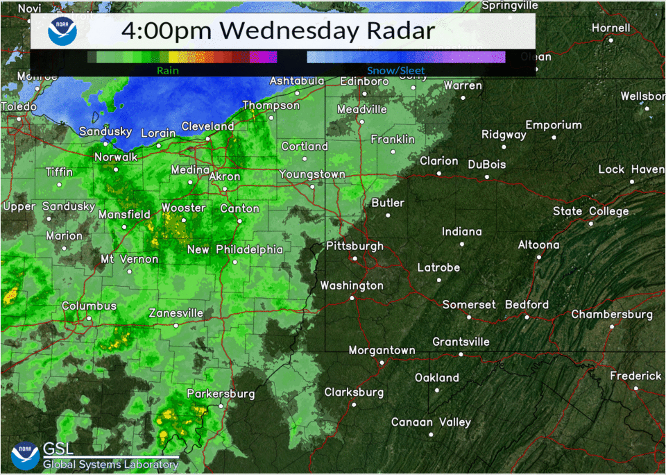
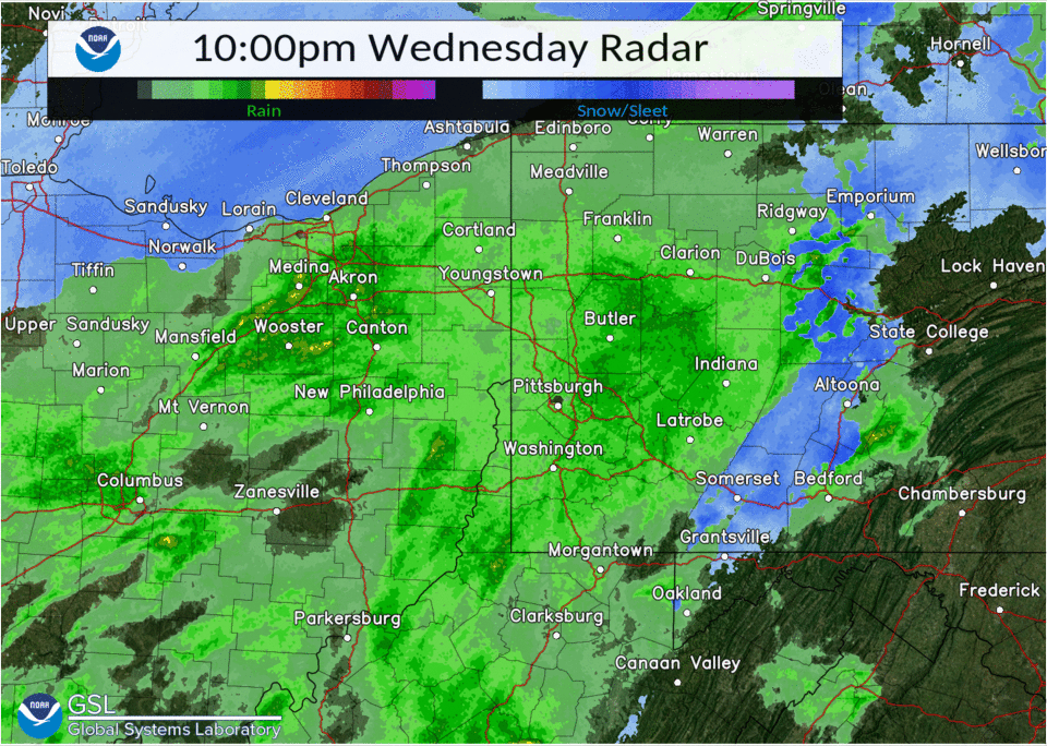
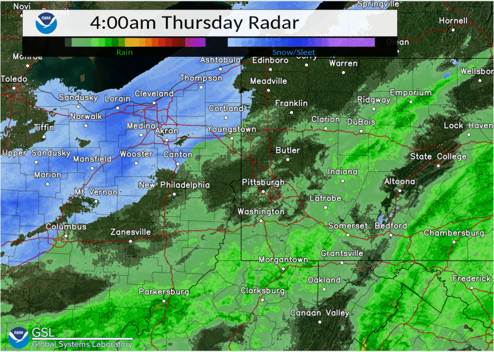
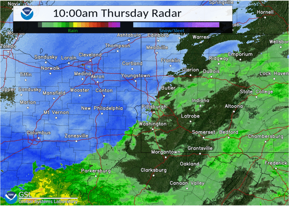
Radar
Note: Watch how the change over to sleet/snow line slowly creeps southeast and then stops over Allegheny County!
 |
 |
 |
 |
|
Precipitation Type Feb 2nd 21Z - Feb 3rd 03Z |
Precipitation Type Feb 3rd 03Z - Feb 3rd 09Z |
Precipitation Type Feb 3rd 09Z - Feb 3rd 15Z |
Precipitation Type Feb 3rd 15Z - Feb 3rd 21Z |
Rain Reports Storm Total
********************STORM TOTAL RAINFALL********************
LOCATION TOTAL TIME/DATE COMMENTS
RAINFALL MEASURED
(inches)
OHIO
...Belmont County...
St. Clairsville 2.15 1132 PM 2/03 CWOP
6 SE Belmont 1.80 1000 PM 2/03 IFLOWS
Blaine 1.75 434 AM 2/04 Trained Spotter
3 SW Mount Pleasant 1.44 700 AM 2/04 IFLOWS
3 WSW Dublin 1.29 707 AM 2/04 CWOP
...Carroll County...
Amsterdam 1.88 700 AM 2/04 HADS
Carrollton 0.54 715 AM 2/03 CWOP
...Columbiana County...
ENE Hanoverton 1.60 400 AM 2/04 CoCoRaHS
3 SE Salem 0.76 1000 PM 2/03 IFLOWS
Leetonia 0.62 716 AM 2/03 CWOP
Columbiana 0.53 718 AM 2/03 CWOP
4 N Wellsville 0.52 900 AM 2/03 CoCoRaHS
Alliance 0.42 715 AM 2/03 CWOP
1 E Lisbon 0.39 700 AM 2/03 HADS
...Coshocton County...
2 NNE Fresno 2.60 800 AM 2/04 CoCoRaHS
Woodbury Wildlife Ar 1.16 1100 PM 2/03 IFLOWS
Coshocton 1.07 1246 PM 2/04 CWOP
3 SE Conesville 0.86 645 AM 2/03 HADS
3 N Coshocton 0.68 700 AM 2/03 IFLOWS
Nellie 0.30 715 AM 2/03 HADS
...Guernsey County...
Quaker City 2.00 800 PM 2/03 IFLOWS
3 SE Kimbolton 1.70 645 AM 2/04 HADS
Kimbolton 1.64 1100 PM 2/03 IFLOWS
5 SE Kimbolton 1.44 900 PM 2/03 IFLOWS
2 E Senecaville 1.32 615 AM 2/04 HADS
1 NE Pleasant City 1.31 700 AM 2/04 HADS
Freeport 0.36 912 PM 2/03 CWOP
3 NE Cambridge 0.05 700 AM 2/03 CoCoRaHS
...Harrison County...
1 N New Athens 2.04 800 PM 2/03 IFLOWS
2 S Bowerston 1.76 800 AM 2/03 IFLOWS
Sewage Plant 1.64 715 AM 2/04 HADS
4 E Deersville 1.60 900 PM 2/03 IFLOWS
1 W Jewett 1.00 700 AM 2/04 IFLOWS
3 E Freeport 0.20 715 AM 2/04 HADS
...Jefferson County...
1 WSW Mount Pleasant 2.08 800 AM 2/04 CoCoRaHS
2 W Brentwood 1.92 600 PM 2/03 IFLOWS
Wintersville 1.23 1250 PM 2/04 CWOP
1 NE Steubenville 1.01 700 AM 2/04 HADS
1 WNW Wintersville 0.49 800 AM 2/03 CoCoRaHS
2 WNW Steubenville 0.06 845 AM 2/03 CoCoRaHS
...Monroe County...
1 W New Martinsville 2.13 700 AM 2/04 HADS
Merrell Ridge 2.06 632 AM 2/04 RAWS
Jerusalem 2.02 922 PM 2/03 CWOP
1 W Beallsville 1.92 800 PM 2/03 IFLOWS
3 E Woodsfield 1.68 700 AM 2/04 HADS
...Muskingum County...
Zanesville Airport 1.75 720 AM 2/04 ASOS
Adamsville 1.60 800 PM 2/03 IFLOWS
Blue Rock 0.88 650 AM 2/03 RAWS
Zanesville 0.75 716 AM 2/03 CWOP
5 SSW Concord 0.70 730 AM 2/03 CoCoRaHS
4 NW Zanesville 0.52 715 AM 2/04 HADS
...Noble County...
3 W Caldwell 2.04 700 PM 2/03 IFLOWS
2 E Sarahsville 1.74 300 PM 2/03 IFLOWS
Jackson Township 1.52 900 PM 2/03 IFLOWS
Summerfield 1.24 900 PM 2/03 IFLOWS
...Tuscarawas County...
1 N Uhrichsville 2.00 700 AM 2/04 CoCoRaHS
1 NW Dennison 1.98 700 AM 2/04 Co-Op Observer
New Philadelphia Air 1.81 700 AM 2/04 ASOS
WNW Carmichaels 0.94 700 AM 2/03 CoCoRaHS
Sugarcreek 0.87 710 AM 2/03 CWOP
New Philadelphia 0.84 720 AM 2/03 CWOP
1 SW New Philadelphi 0.84 700 AM 2/03 HADS
5 WNW Dover 0.81 730 AM 2/03 CoCoRaHS
7 SE Mineral City 0.74 800 AM 2/03 CoCoRaHS
2 SE Beach City 0.58 715 AM 2/03 HADS
Uhrichsville 0.44 1000 PM 2/03 IFLOWS
3 N New Philadelphia 0.34 715 AM 2/03 HADS
4 SE Port Washington 0.28 700 PM 2/03 IFLOWS
PENNSYLVANIA
...Allegheny County...
Pittsburgh 2.42 700 PM 2/03 CWOP
NW Aspinwall 2.34 700 AM 2/04 CoCoRaHS
1 NE Green Tree 2.25 700 AM 2/04 IFLOWS
Shaler Township 2.21 700 AM 2/04 IFLOWS
1 SE Pleasant Hills 2.16 700 AM 2/04 IFLOWS
Plum 2.11 700 AM 2/04 IFLOWS
Baldwin 2.11 700 AM 2/04 IFLOWS
1 NW Bridgeville 2.10 700 AM 2/04 IFLOWS
1 NW Churchill 1.97 600 AM 2/04 IFLOWS
4 SW Pittsburgh 1.94 700 AM 2/04 CoCoRaHS
2 SE South Fayette 1.94 700 AM 2/04 CoCoRaHS
2 NW Sturgeon-Nobles 1.93 700 AM 2/04 IFLOWS
1 SW Bridgeville 1.92 700 AM 2/04 CoCoRaHS
1 SE Blawnox 1.87 700 AM 2/04 IFLOWS
1 SE Millvale 1.87 500 AM 2/04 IFLOWS
Braddock Lock And Da 1.86 600 AM 2/04 Co-Op Observer
Allegheny County Air 1.85 1253 PM 2/04 ASOS
2 S McCandless Towns 1.85 700 AM 2/04 CoCoRaHS
2 SE Lincoln 1.84 705 AM 2/04 IFLOWS
Forest Hills 1.78 1246 AM 2/04 CWOP
1 NE Gibsonia 1.77 530 AM 2/04 CoCoRaHS
2 WNW Imperial 1.75 800 AM 2/04 CoCoRaHS
Glassport 1.67 728 AM 2/04 CWOP
1 WSW West Mifflin 1.62 725 AM 2/04 AWS
2 NE Moon 1.59 700 AM 2/04 Co-Op Observer
Dawson 1.56 705 AM 2/04 CWOP
1 S Acmetonia 1.52 600 AM 2/04 Co-Op Observer
2 WNW Coraopolis 1.50 800 AM 2/04 CoCoRaHS
Sewickley 1.44 930 PM 2/03 CWOP
2 NW Jefferson 1.43 1000 PM 2/03 CoCoRaHS
Castle Shannon 1.41 1246 AM 2/04 CWOP
Churchill 1.41 708 AM 2/04 CWOP
Fox Chapel 1.40 400 AM 2/04 AWS
1 WNW Pittsburgh 1.36 725 AM 2/04 AWS
1 WSW Plum 1.34 725 AM 2/04 AWS
Monroeville 1.32 725 AM 2/04 AWS
Cuddy 1.31 701 AM 2/04 CWOP
Pennsbury Village 1.26 725 AM 2/04 AWS
1 W Edgeworth 1.25 600 AM 2/04 Co-Op Observer
Bakerstown 1.25 730 AM 2/04 CWOP
Mt Lebanon 1.24 1244 AM 2/04 CWOP
Pittsburgh Intl Airp 1.23 1251 PM 2/04 ASOS
O`Hara Township 1.22 725 AM 2/04 AWS
1 SW Heidelberg 1.19 725 AM 2/04 AWS
Robinson Township 1.18 725 AM 2/04 AWS
Upper Saint Clair 1.17 725 AM 2/04 AWS
White Oak 1.17 1245 AM 2/04 CWOP
Bethel Park 1.16 1240 AM 2/04 CWOP
1 N Bethel Park 1.16 725 AM 2/04 AWS
1 W Heidelberg 1.16 725 AM 2/04 AWS
Hampton Township 1.09 1250 AM 2/04 AWS
I-79 N/B @ Exit 60 C 0.81 650 AM 2/04 PADOT
Ben Avon 0.78 700 AM 2/04 HADS
Imperial 0.76 1255 AM 2/04 Public
1 N Imperial 0.76 1159 PM 2/03 Public
4 NW Imperial-Enlow 0.62 500 AM 2/04 IFLOWS
I-376 W/B @ Exit 10A 0.55 720 AM 2/04 PADOT
2 N Carnot-Moon 0.42 700 PM 2/03 IFLOWS
5 S Pittsburgh 0.38 700 AM 2/03 CoCoRaHS
Wexford 0.28 725 AM 2/04 AWS
...Armstrong County...
4 S Lenape Heights 2.05 700 AM 2/04 Co-Op Observer
6 N Vandergrift 2.03 700 AM 2/04 CoCoRaHS
3 NNW Shelocta 2.01 700 AM 2/04 CoCoRaHS
4 NW Dayton 1.92 600 AM 2/04 Co-Op Observer
1 SSW Kittanning 1.84 700 AM 2/04 CoCoRaHS
3 NW Dayton 1.63 645 AM 2/04 HADS
Distant 1.41 632 AM 2/04 RAWS
West Kittanning 1.29 700 AM 2/04 HADS
Worthington 1.23 702 AM 2/04 CWOP
Kittanning 0.99 656 PM 2/03 CWOP
1 N Parker 0.92 700 AM 2/04 HADS
...Beaver County...
Ambridge 1.16 700 AM 2/04 CWOP
Rochester 1.05 903 AM 2/03 CWOP
Aliquippa 0.87 645 PM 2/03 CWOP
6 W Beaver 0.65 700 AM 2/04 CoCoRaHS
2 SSE Beaver 0.58 725 AM 2/04 AWS
Hookstown 0.25 725 AM 2/04 AWS
...Butler County...
N Cabot 1.78 1130 AM 2/04 CoCoRaHS
2 NNE Fox Run 1.74 600 AM 2/04 CoCoRaHS
2 WNW Cabot 1.72 700 AM 2/04 CoCoRaHS
5 SE Slippery Rock 1.72 800 AM 2/04 CoCoRaHS
1 S Slippery Rock 1.69 823 AM 2/04 Co-Op Observer
3 NNE Shanor-Northvu 1.60 700 AM 2/04 CoCoRaHS
2 NE Sarver 1.60 456 AM 2/04 CoCoRaHS
Cranberry Township 1.47 700 AM 2/04 CWOP
I-79 S/B MM 86 @ Eva 1.38 720 AM 2/04 PADOT
Butler County Airpor 1.25 656 AM 2/04 AWOS
4 NW Cabot 1.15 1050 AM 2/04 Trained Spotter
Renfrew 1.12 658 PM 2/03 CWOP
Harmony 1.03 700 PM 2/03 CWOP
1 NW Cranberry 1.01 1000 AM 2/04 Public
I-79 S/B @ MM 100 Co 1.00 720 AM 2/04 PADOT
Moraine State Park 0.94 650 AM 2/04 RAWS
Saxonburg 0.80 725 AM 2/04 AWS
Butler 0.71 658 PM 2/03 CWOP
1 SW Meridian 0.70 800 AM 2/04 CoCoRaHS
2 W Butler 0.51 700 AM 2/03 CoCoRaHS
...Clarion County...
3 SW Clarion 2.05 700 AM 2/04 Co-Op Observer
4 WNW Summerville 1.80 800 AM 2/04 CoCoRaHS
Cooksburg 1.55 710 AM 2/04 Co-Op Observer
New Bethlehem 1.23 724 AM 2/04 AWS
5 N Hawthorn 0.76 145 PM 2/03 CoCoRaHS
Clarion 0.74 724 AM 2/04 AWS
SW Marble 0.68 845 PM 2/03 Public
I-80 MM 67 @ CL Scho 0.60 720 AM 2/04 PADOT
I-80 E/B MM 55 @ Kno 0.47 720 AM 2/04 PADOT
...Fayette County...
1 SW South Connellsv 2.21 520 AM 2/04 Co-Op Observer
N Perryopolis 2.07 700 AM 2/04 CoCoRaHS
1 SE Point Marion 1.99 700 AM 2/04 CoCoRaHS
6 SW Ohiopyle 1.91 600 AM 2/04 HADS
1 ENE Connellsville 1.72 725 AM 2/04 AWS
Seven Springs 1.42 720 AM 2/04 AWS
SW Brownsville 1.32 735 PM 2/03 CoCoRaHS
3 E Point Marion 1.02 715 AM 2/04 HADS
2 NNE Uniontown 1.00 552 PM 2/03 CoCoRaHS
Champion 0.72 658 AM 2/04 CWOP
...Forest County...
5 W Marienville 2.02 620 AM 2/04 CoCoRaHS
7 SSE Tionesta 1.61 700 AM 2/04 CoCoRaHS
1 S Tionesta 1.31 1245 PM 2/04 HADS
Allegheny 0.50 707 AM 2/04 RAWS
6 NE Tionesta 0.41 700 AM 2/03 HADS
...Greene County...
1 E Waynesburg 2.26 700 AM 2/04 Co-Op Observer
1 SW Point Marion 2.23 600 AM 2/04 Co-Op Observer
1 ESE Graysville 1.87 600 AM 2/04 HADS
5 WNW Spraggs 1.63 705 AM 2/04 AWS
Waynesburg 1.35 1249 PM 2/04 CWOP
I-79 N/B @ MM 6 Welc 1.24 655 AM 2/04 PADOT
1 WNW Greensboro 1.18 725 AM 2/04 AWS
...Indiana County...
2 ESE Chevy Chase He 2.28 700 AM 2/04 CoCoRaHS
1 SE Brush Valley 2.22 730 AM 2/04 CoCoRaHS
2 W Pikes Peak 2.21 645 AM 2/04 Public
Yellow Creek State P 2.12 643 AM 2/04 RAWS
SR 22 W/B @ Penn Vie 1.44 720 AM 2/04 PADOT
6 NE Clymer 1.43 656 PM 2/03 CWOP
Marion Center 1.41 700 AM 2/04 CWOP
SR 422 E/B @ Penn Ru 1.40 720 AM 2/04 PADOT
Rochester Mills 1.27 652 PM 2/03 CWOP
Indiana 0.47 725 AM 2/04 AWS
...Jefferson County...
Punxsutawney 1.78 710 AM 2/04 CWOP
Brookville 1.58 700 AM 2/04 HADS
DuBois Airport 1.41 1255 PM 2/04 ASOS
S Timblin 1.22 715 AM 2/04 CoCoRaHS
I-80 E/B @ Exit 90 D 0.99 655 AM 2/04 PADOT
...Lawrence County...
New Castle Airport 0.65 656 AM 2/04 AWOS
...Mercer County...
1 E Sharpsville 1.34 1245 PM 2/04 HADS
Sandy Lake 0.98 715 AM 2/04 HADS
2 SW Hermitage 0.64 915 AM 2/03 CoCoRaHS
Mercer 0.51 715 AM 2/03 CWOP
I-79 N/B MM 136.4 @ 0.40 720 AM 2/04 PADOT
Greenville 0.39 725 AM 2/03 AWS
I-80/I-79 JCT Mercer 0.38 720 AM 2/04 PADOT
I-80 E/B @ MM 11 /Ex 0.29 720 AM 2/04 PADOT
3 N Slippery Rock 0.15 1215 AM 2/04 HADS
...Venango County...
8 ENE Kennerdell 1.61 800 AM 2/04 CoCoRaHS
1 E Cooperstown 1.55 700 AM 2/04 CoCoRaHS
NW Reno 1.55 630 AM 2/04 CoCoRaHS
1 SSW Franklin 1.55 600 AM 2/04 CoCoRaHS
1 E Franklin 1.33 920 AM 2/04 Co-Op Observer
6 SW Titusville 1.07 700 AM 2/04 CoCoRaHS
SR 322 W/B @ Venango 1.03 719 AM 2/04 PADOT
Franklin Airport 0.97 1256 PM 2/04 AWOS
1 NW Rouseville 0.61 645 AM 2/04 HADS
Oil City 0.50 720 AM 2/03 CWOP
Pleasantville 0.48 716 AM 2/03 CWOP
1 NNE Seneca 0.38 700 AM 2/03 CoCoRaHS
SR 8 N/B @ SR 308 Ve 0.36 720 AM 2/04 PADOT
Seneca 0.33 725 AM 2/04 AWS
Hasson Heights 0.30 725 AM 2/03 AWS
5 N Sugarcreek 0.28 700 AM 2/03 IFLOWS
...Washington County...
Avella Rain 2.54 1045 PM 2/03 HADS
McMurray 2.03 700 AM 2/04 CoCoRaHS
1 NNW Finleyville 1.98 800 AM 2/04 CoCoRaHS
Donora 1.87 658 AM 2/04 CWOP
1 W Canonsburg 1.82 700 AM 2/04 CoCoRaHS
2 NE Marianna 1.78 700 AM 2/04 HADS
Washington County Ai 1.67 1256 PM 2/04 AWOS
1 SW California 1.41 725 AM 2/04 AWS
I-79 N/B @ Exit 40 M 1.41 720 AM 2/04 PADOT
4 NW Canonsburg 1.40 700 AM 2/04 CoCoRaHS
North Charleroi 1.39 725 AM 2/04 AWS
Bentleyville 1.26 1245 AM 2/04 CWOP
Cecil 1.16 758 PM 2/03 CWOP
I-70 E/B MM 5 @ Welc 1.06 720 AM 2/04 PADOT
1 SSW Washington 0.97 725 AM 2/04 AWS
Blainsburg 0.63 1241 AM 2/04 CWOP
WNW Bulger 0.45 710 AM 2/03 CoCoRaHS
1 WNW Venetia 0.41 700 AM 2/03 CoCoRaHS
...Westmoreland County...
2 NW Donegal 2.30 700 AM 2/04 Co-Op Observer
1 SW Laughlintown 2.14 800 AM 2/04 Co-Op Observer
1 E Ligonier 2.11 700 AM 2/04 CoCoRaHS
1 SW New Stanton 2.10 726 AM 2/04 Co-Op Observer
1 SW Leechburg 2.09 700 AM 2/04 CoCoRaHS
Trafford 2.02 600 AM 2/04 IFLOWS
Quarry Trail 1.95 709 AM 2/04 RAWS
Youngstown 1.92 725 AM 2/04 AWS
1 NE Mount Pleasant 1.80 725 AM 2/04 AWS
1 S Donegal 1.80 724 AM 2/04 AWS
1 NW Seward 1.79 645 AM 2/04 HADS
Belle Vernon 1.79 708 AM 2/04 CWOP
3 E North Washington 1.70 700 AM 2/04 Co-Op Observer
Latrobe 1.66 700 AM 2/04 CWOP
3 WSW Smithton 1.65 925 AM 2/04 CoCoRaHS
New Alexandria 1.55 1248 AM 2/04 CWOP
1 N Greensburg 1.52 725 AM 2/04 AWS
Jeannette 1.46 724 AM 2/04 AWS
1 ESE Adamsburg 1.43 725 AM 2/04 AWS
1 NNE New Kensington 1.34 1244 AM 2/04 CWOP
1 W Vandergrift 1.28 655 AM 2/04 AWS
Stahlstown 1.26 707 AM 2/04 CWOP
Arnold 1.24 655 AM 2/04 AWS
Luxor 1.13 646 AM 2/04 CWOP
I-70 E/B @ MM 48 You 1.11 720 AM 2/04 PADOT
1 ENE Manor 1.00 236 PM 2/03 AWS
ESE New Florence 0.90 945 AM 2/04 CoCoRaHS
NNE Adamsburg 0.68 115 PM 2/03 CoCoRaHS
SE Ligonier 0.55 700 AM 2/03 CoCoRaHS
1 W Monessen 0.50 1000 PM 2/03 CoCoRaHS
4 E New Kensington 0.47 1000 AM 2/03 CoCoRaHS
1 S Irwin 0.46 700 AM 2/03 CoCoRaHS
3 NNW New Stanton 0.44 655 AM 2/03 CoCoRaHS
2 S Saltsburg 0.43 630 AM 2/03 Co-Op Observer
1 NNE North Irwin 0.02 720 AM 2/03 AWS
WEST VIRGINIA
...Brooke County...
Archer Heights 1.80 100 AM 2/04 IFLOWS
Weirton 1.15 645 PM 2/03 CWOP
...Hancock County...
New Cumberland 2.23 726 PM 2/03 CWOP
2 E New Cumberland 1.80 600 PM 2/03 IFLOWS
Kings Creek 1.16 1000 PM 2/03 IFLOWS
Tomlinson Run 1.07 116 PM 2/03 RAWS
1 E Chester 0.96 400 PM 2/03 IFLOWS
...Marion County...
2 W Mannington 2.84 1245 PM 2/04 HADS
4 W Mannington 2.84 500 AM 2/04 IFLOWS
5 N Grafton 2.64 700 AM 2/04 IFLOWS
2 N Rivesville 2.52 600 AM 2/04 CoCoRaHS
2 SW Fairview 2.48 600 AM 2/04 IFLOWS
Fairmont 1.80 648 AM 2/04 CWOP
1 SSE Fairmont 1.76 1200 AM 2/04 Co-Op Observer
3 SE Colfax 1.48 900 AM 2/04 Public
...Marshall County...
3 N Lynn Camp 2.80 100 AM 2/04 IFLOWS
2 NE Moundsville 2.48 1000 PM 2/03 IFLOWS
4 NE Cameron 2.36 300 AM 2/04 IFLOWS
Cameron 2.18 1215 PM 2/04 HADS
4 NW Littleton 2.00 200 AM 2/04 IFLOWS
5 S Valley Grove 1.12 600 AM 2/04 IFLOWS
...Monongalia County...
2 SW Cassville 3.08 700 AM 2/04 IFLOWS
4 NE Fairview 2.96 700 AM 2/04 IFLOWS
3 S Wadestown 2.60 500 AM 2/04 IFLOWS
Morgantown Dam 2.55 700 AM 2/04 Co-Op Observer
6 WSW Morgantown 2.45 700 AM 2/04 CoCoRaHS
4 NE Rivesville 2.32 700 AM 2/04 IFLOWS
6 SW Morgantown 2.28 700 AM 2/04 CoCoRaHS
Morgantown 2.23 725 AM 2/04 CWOP
1 SE Westover 1.87 1215 PM 2/04 HADS
1 NNW Morgantown 1.74 725 AM 2/04 AWS
Morgantown Airport 1.37 1253 PM 2/04 ASOS
I-68 at MM 11 0.47 705 AM 2/04 WVDOT
I-79 at I-68 0.28 1250 PM 2/04 WVDOT
...Ohio County...
2 S Valley Grove 2.16 1200 AM 2/04 IFLOWS
4 NNE Valley Grove 2.06 700 AM 2/04 CoCoRaHS
3 N Wheeling 1.87 600 AM 2/04 Co-Op Observer
2 E Bethlehem 1.47 1215 AM 2/04 HADS
Bethlehem 1.40 600 AM 2/04 IFLOWS
Wheeling Airport 1.29 1253 PM 2/04 ASOS
...Preston County...
4 N Bruceton Mills 2.28 700 AM 2/04 IFLOWS
3 N Tunnelton 2.20 500 AM 2/04 IFLOWS
5 NE Brandonville 2.08 600 AM 2/04 IFLOWS
WVU Research Forest 2.00 612 AM 2/04 RAWS
Kingwood 1.90 1217 PM 2/04 RAWS
7 SE Brandonville 1.84 400 AM 2/04 IFLOWS
3 S Bruceton Mills 1.80 700 AM 2/04 CoCoRaHS
Cheat River 1.80 1245 PM 2/04 HADS
1 WNW Kingwood 1.58 1255 PM 2/04 AWS
E Terra Alta 1.52 700 AM 2/04 CoCoRaHS
5 S Newburg 1.28 1200 AM 2/04 IFLOWS
7 N Thomas 1.16 700 AM 2/04 CoCoRaHS
2 S Tunnelton 1.08 600 AM 2/04 IFLOWS
Reedsville 0.70 646 PM 2/03 CWOP
...Tucker County...
CANAAN VALLEY SP ELK 2.33 600 AM 2/04 HADS
3 NE Hendricks 2.08 700 AM 2/04 IFLOWS
7 S Rowlesburg 1.28 715 AM 2/04 IFLOWS
Canaan Heights 1.21 1200 PM 2/04 RAWS
Davis 1.21 700 AM 2/04 Co-Op Observer
9 N Parsons 1.18 1245 AM 2/04 HADS
3 S Canaan Hgts 1.12 900 AM 2/04 Co-Op Observer
6 SSE Davis 0.96 700 AM 2/04 CoCoRaHS
...Wetzel County...
2 N Glover Gap 2.89 730 AM 2/04 Co-Op Observer
7 E New Martinsville 2.74 800 AM 2/04 CoCoRaHS
5 E New Martinsville 2.44 400 AM 2/04 IFLOWS
3 S Smithfield 2.36 700 AM 2/04 IFLOWS
1 SE Hundred 2.21 1215 PM 2/04 HADS
New Martinsville 1.36 700 AM 2/04 CWOP
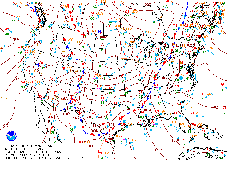
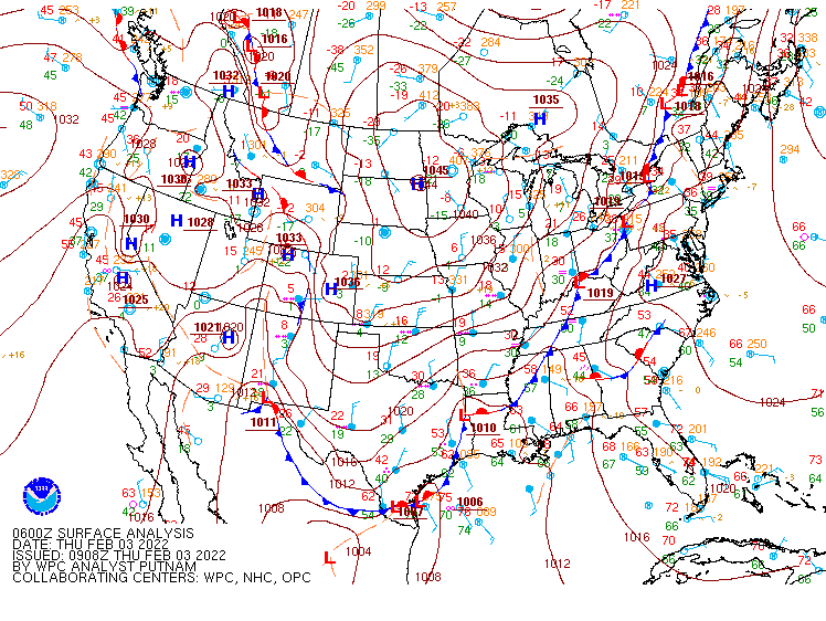
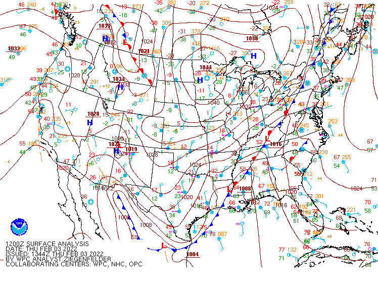
Environment
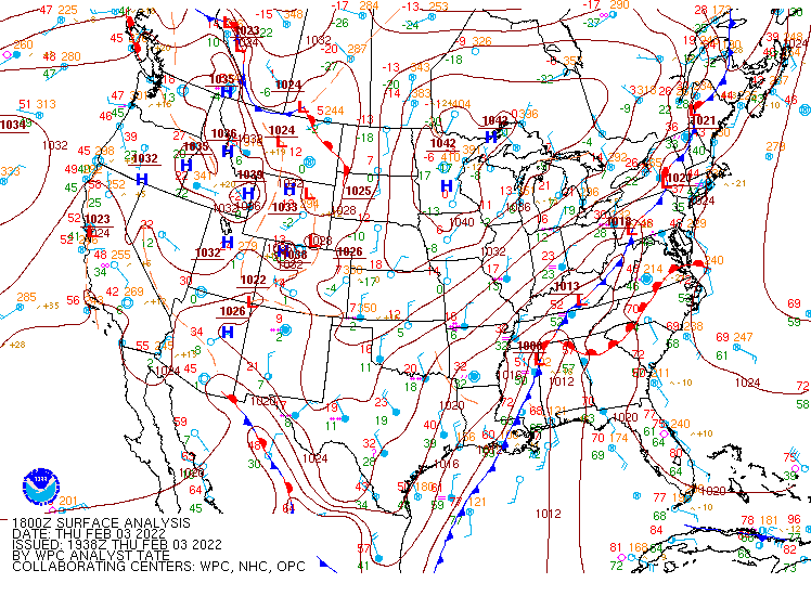
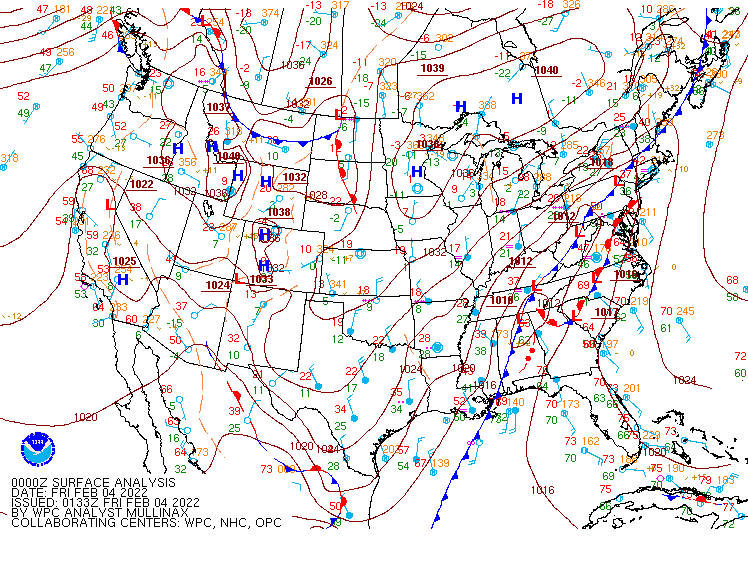
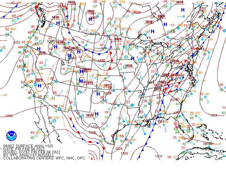
Surface Analysis Maps from WPC
 |
 |
 |
|
February 3rd 2022 00Z |
February 3rd 2022 06Z |
February 3rd 2022 12Z |
 |
 |
 |
|
February 3rd 2022 18Z |
February 4th 2022 00Z |
February 4th 2022 06Z |
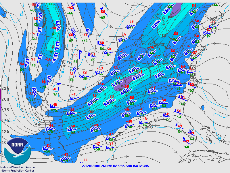
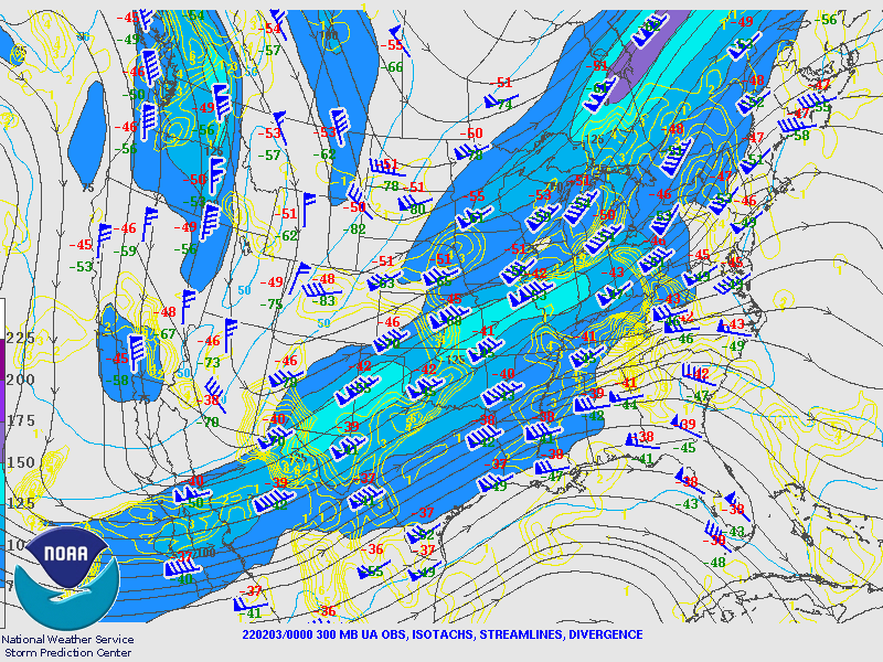
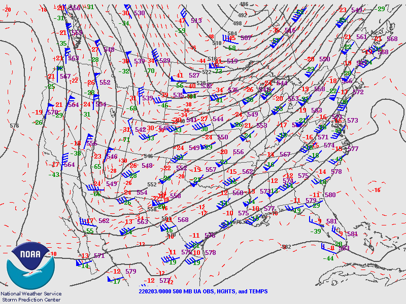
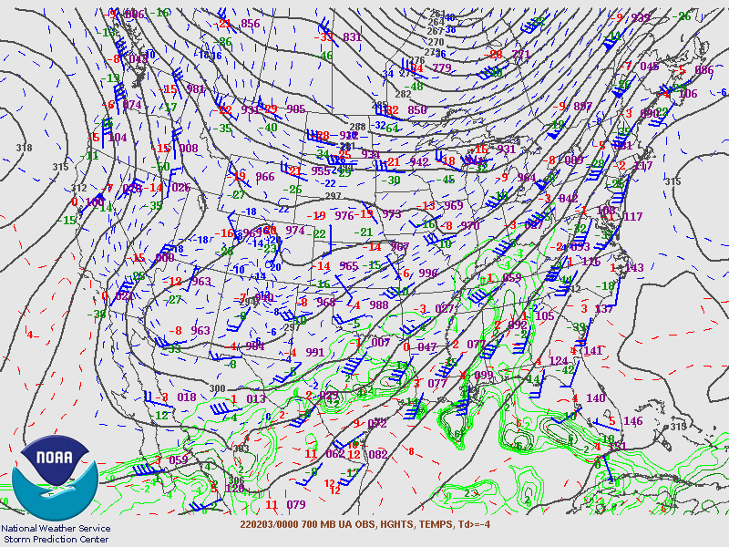
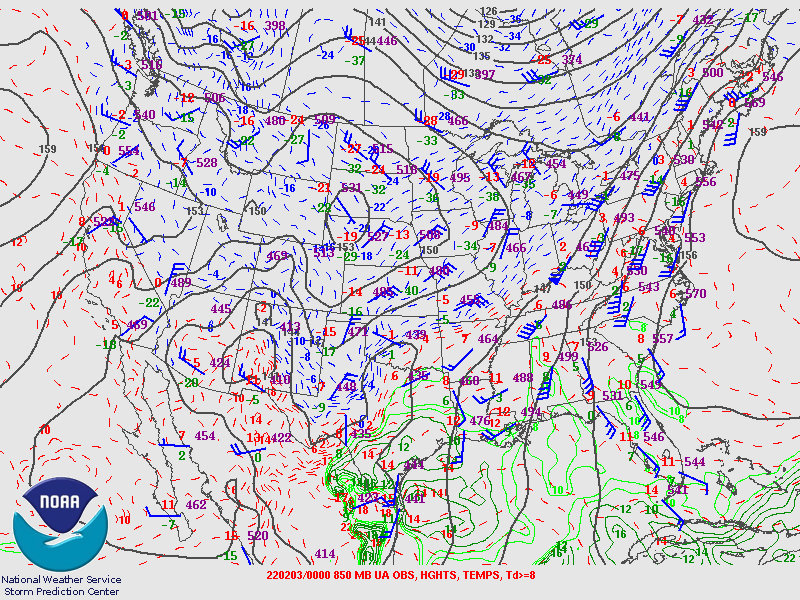
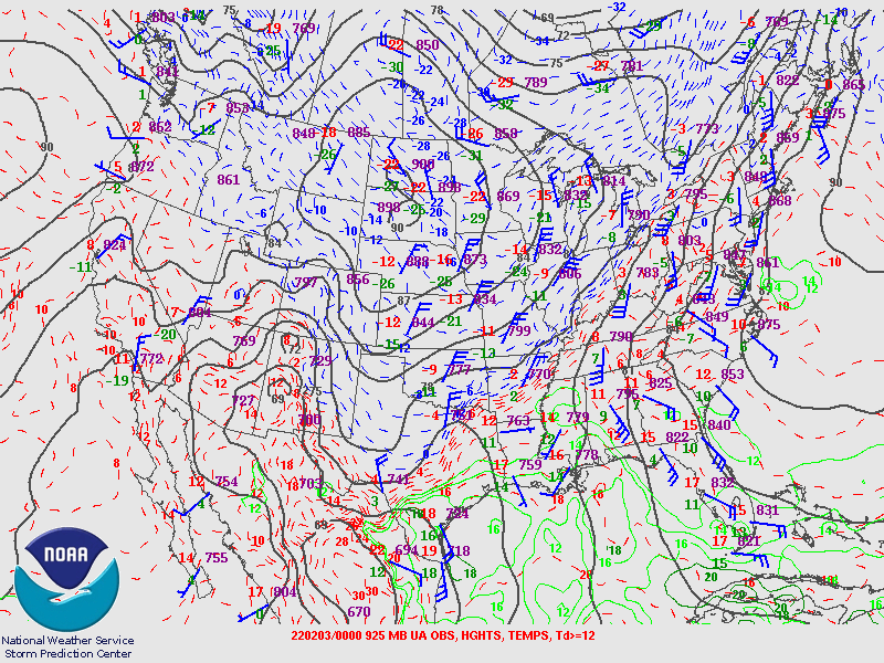
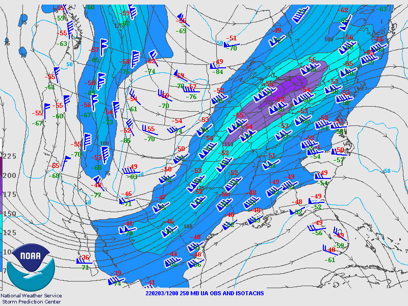
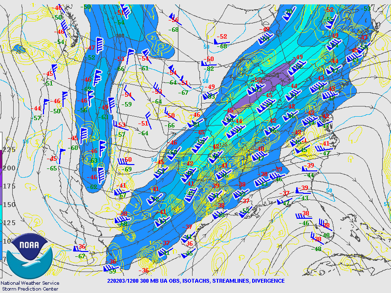
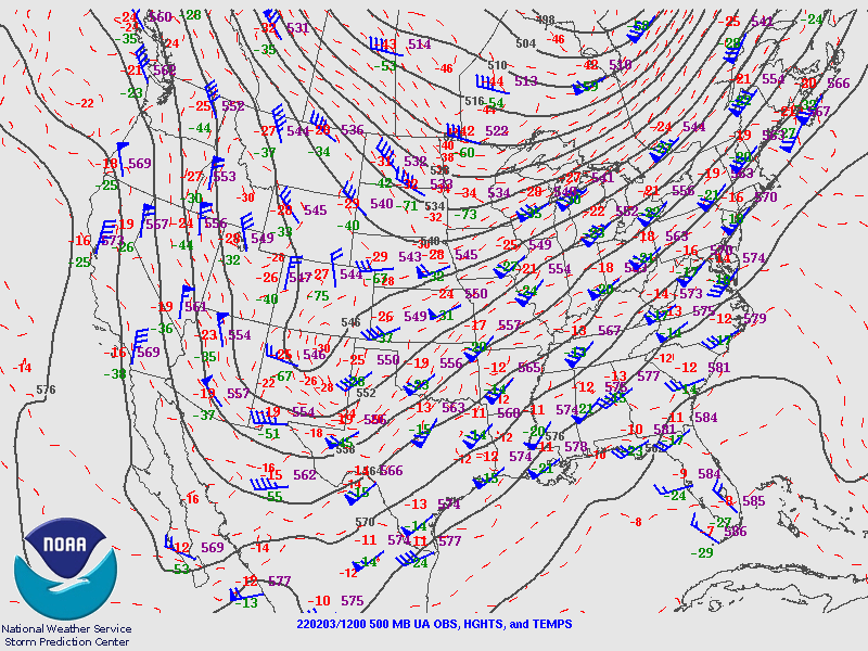
Upper Air Maps from SPC
 |
 |
 |
|
February 3rd 2022 00Z 250MB Map |
February 3rd 2022 00Z 300MB Map |
February 3rd 2022 00Z 500MB Map |
 |
 |
 |
|
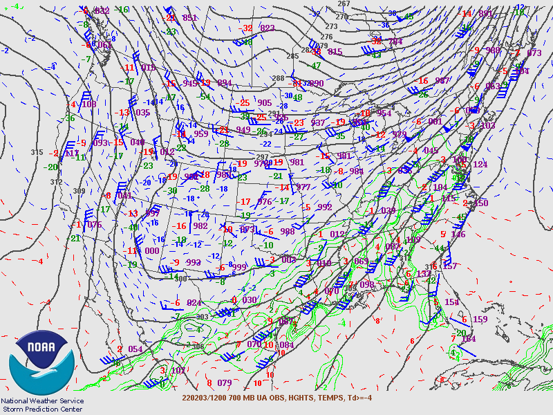
February 3rd 2022 00Z 700MB Map |
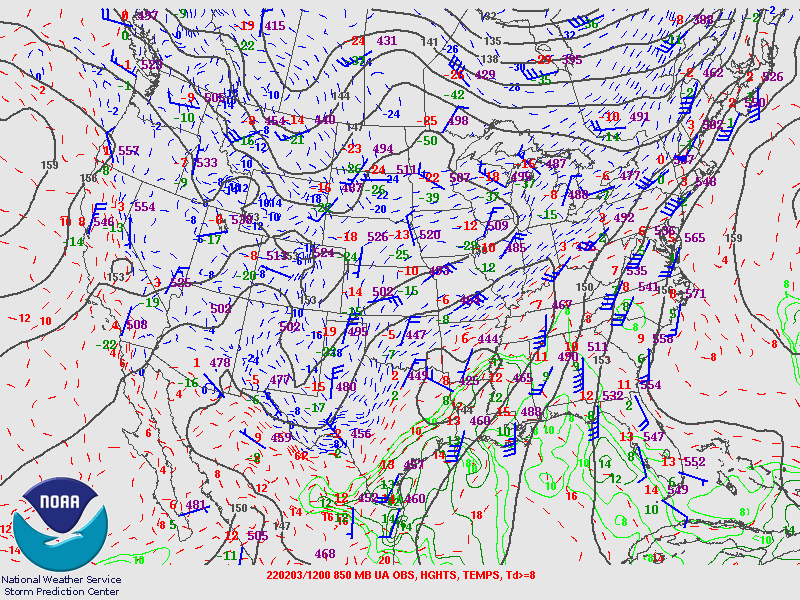
February 3rd 2022 00Z 850MB Map |
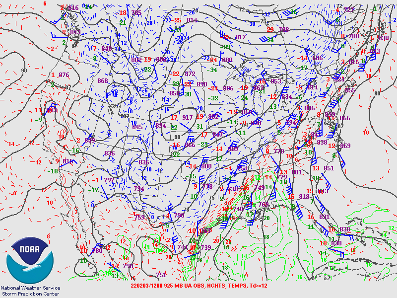
February 3rd 2022 00Z 925MB Map |
 |
 |
 |
|
February 3rd 2022 12Z 250MB Map |
February 3rd 2022 12Z 300MB Map |
February 3rd 2022 12Z 500MB Map |
 |
 |
 |
|
February 3rd 2022 12Z 700MB Map |
February 3rd 2022 12Z 850MB Map |
February 3rd 2022 12Z 925MB Map |
Additional Information
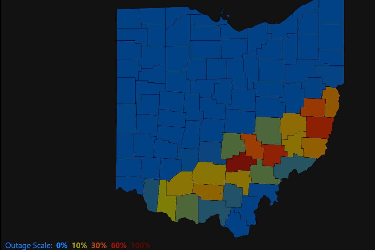
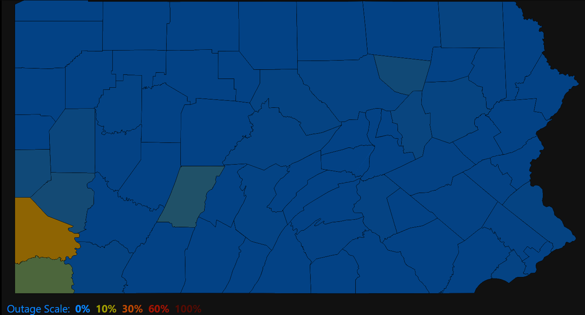
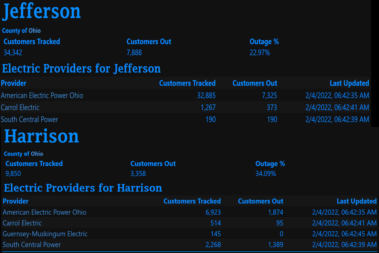
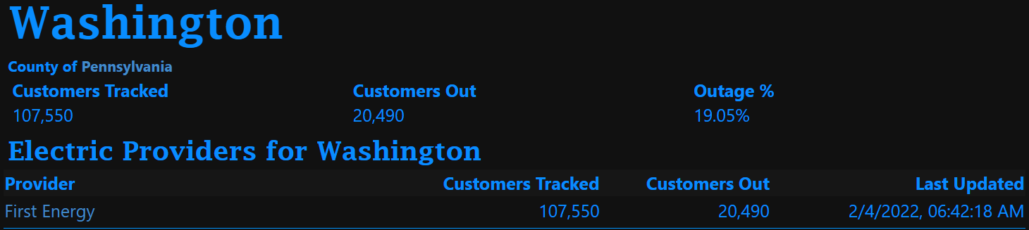
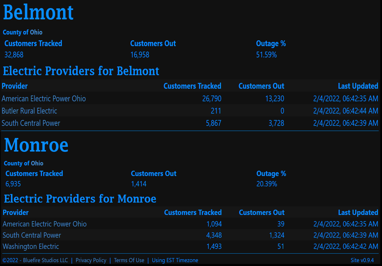
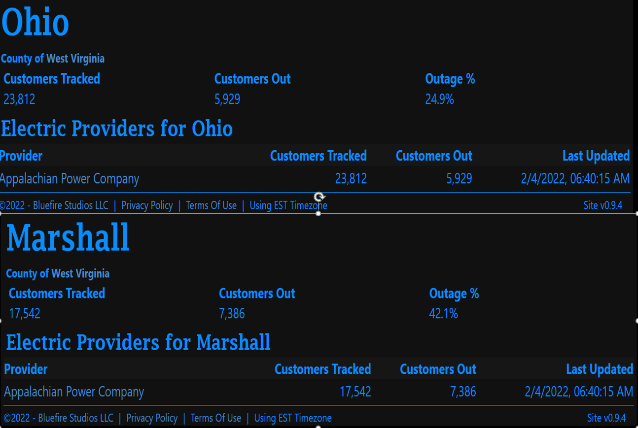
Power Outage Maps from: (Credit to http://poweroutage.us/)
 |
 |
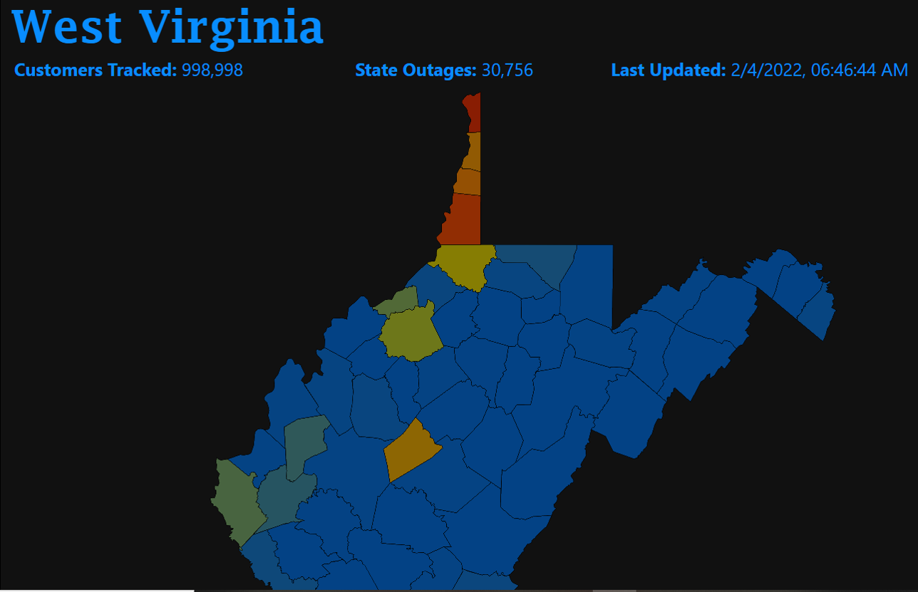 |
| Ohio Power Outage Map | Pennsylvania Power Outage Map | West Virginia Power Outage Map |
 |
 |
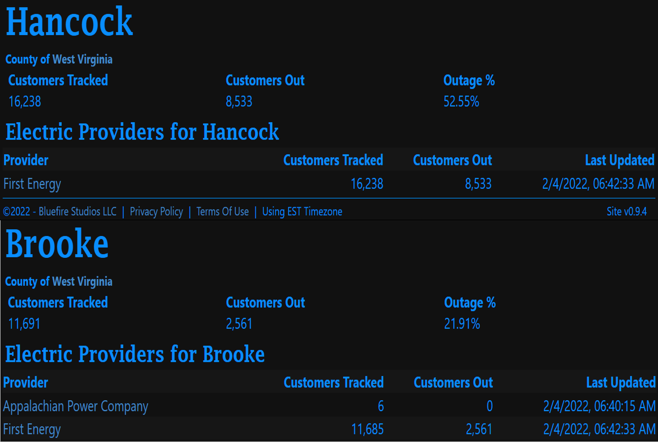 |
| Ohio Power Outage County Statistics | Pennsylvania Power Outage County Statistics | West Virginia Power Outage County Statistics |
 |
 |
| Ohio Power Outage County Statistics | West Virginia Power Outage County Statistics |
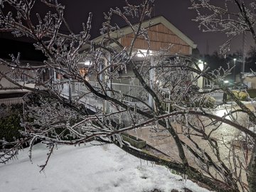
Pictures
 |
 |
.png) |
|
NWS Office in Moon Township, PA Credit: Jared Rackley |
St. Clairsville, OH Credit: Michael Harvilla |
St. Clairsville, OH Credit: Michael Harvilla |
.png) |
 |
|
Muskingum River, OH Credit: Muskingum County Emergency Management |
Imperial, PA Credit: David Shallenberger |
Summaries from other NWS Offices
 |
Media use of NWS Web News Stories is encouraged! Please acknowledge the NWS as the source of any news information accessed from this site. |
|