Overview
|
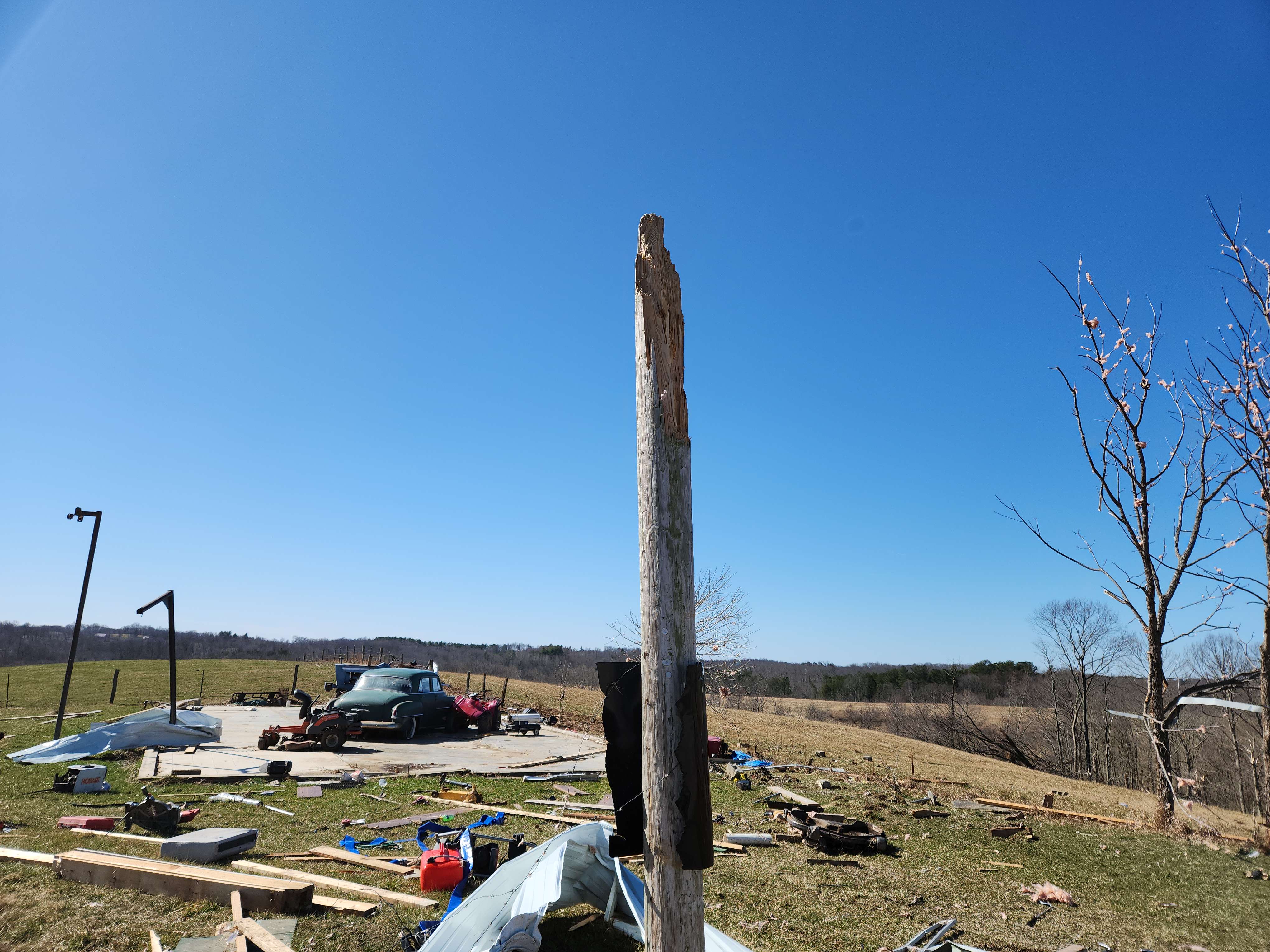
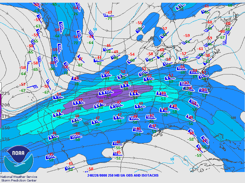
On the evening of February 27th 2024, a strong low pressure system developed over the Upper Midwest. The surface low tracked east along the Lower Great Lakes region into the overnight hours of the 28th. By 4am on the 28th, a warm front lifted northeast through the Upper Ohio Valley putting the Pittsburgh forecast area within the warm sector. The warm and moist unstable air advecting into the region set the stage for convection to organize. Winds aloft were impressive with 50 to 60 knot synoptic winds just off the surface according to the 12Z sounding. The environment in place along with the 40 to 50 knot effective bulk shear made conditions favorable for the extension and inclusion of some Ohio counties for a Tornado Watch. A severe storm developed and moved into the forecast area by 7am on the 28th. The storm produced an EF-2 Tornado and the storm itself contained the environment conditions to produce 70mph winds. |
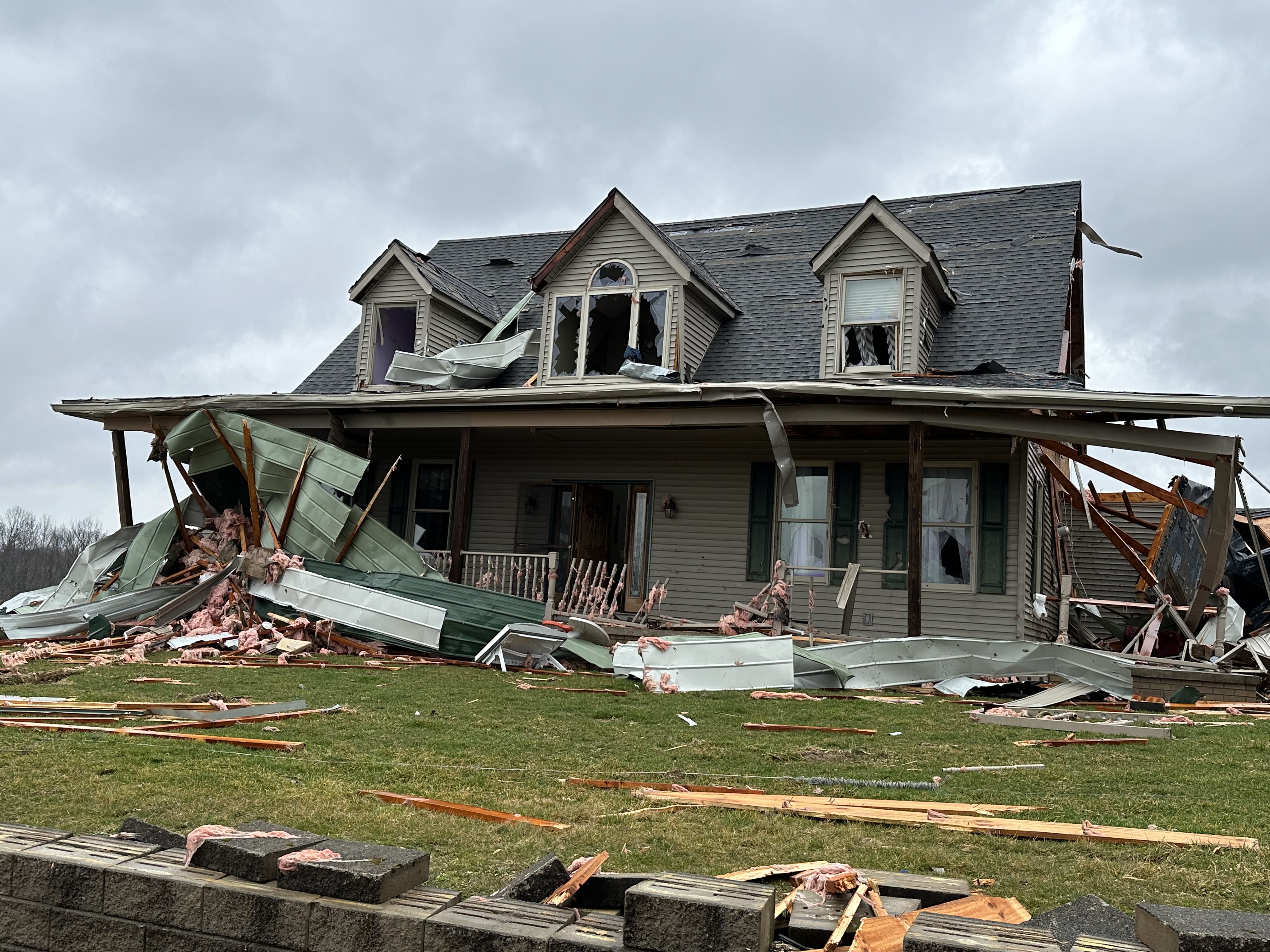 Monroe County Ohio |
Tornadoes
|
Tornado - LOCATION
Track Map 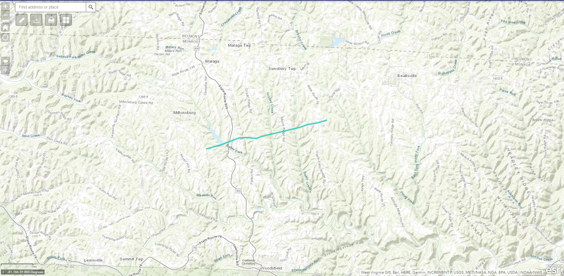 
Downloadable KMZ File |
||||||||||||||||
|
||||||||||||||||
The Enhanced Fujita (EF) Scale classifies tornadoes into the following categories:
| EF0 Weak 65-85 mph |
EF1 Moderate 86-110 mph |
EF2 Significant 111-135 mph |
EF3 Severe 136-165 mph |
EF4 Extreme 166-200 mph |
EF5 Catastrophic 200+ mph |
 |
|||||
Wind
Wind Reports
Public Information Statement
Spotter Reports
National Weather Service Pittsburgh PA
916 PM EST Wed Feb 28 2024
The following are unofficial observations taken during the past 24
hours for the gusty wind that has been affecting our region.
Appreciation is extended to highway departments, cooperative
observers, Skywarn spotters and media for these reports. This summary
also is available on our home page at weather.gov/pittsburgh
**************PEAK WIND GUST (AT LEAST 35 MPH)**************
LOCATION MAX WIND TIME/DATE COMMENTS
GUST
MEASURED
(mph)
| OHIO | |||||
| ...Carroll County... | |||||
| Carrollton | 36 | 630 | AM | 2/28 | Mesonet |
| ...Jefferson County... | |||||
| Jefferson County Air | 43 | 415 | PM | 2/28 | Mesonet |
| Wintersville | 43 | 635 | PM | 2/28 | AWOS |
| ...Muskingum County... | |||||
| Zanesville Airport | 43 | 411 | PM | 2/28 | ASOS |
| ...Tuscarawas County... | |||||
| New Philadelphia Air | 41 | 510 | PM | 2/28 | ASOS |
| PENNSYLVANIA | |||||
| ...Allegheny County... | |||||
| Pittsburgh Intl Airp | 52 | 349 | PM | 2/28 | ASOS |
| West Mifflin | 45 | 604 | PM | 2/28 | AWOS |
| Moon Township | 41 | 648 | PM | 2/28 | Mesonet |
| Dawson | 35 | 258 | PM | 2/28 | Mesonet |
| ...Beaver County... | |||||
| Beaver Falls Airport | 35 | 647 | PM | 2/28 | AWOS |
| Zelienople Airport | 35 | 235 | PM | 2/28 | Mesonet |
| ...Butler County... | |||||
| Butler County Airpor | 43 | 703 | PM | 2/28 | AWOS |
| ...Fayette County... | |||||
| Connellsville Airpor | 46 | 855 | AM | 2/28 | AWOS |
| ...Indiana County... | |||||
| Indiana Airport | 44 | 315 | PM | 2/28 | AWOS |
| ...Jefferson County... | |||||
| DuBois Airport | 47 | 233 | PM | 2/28 | ASOS |
| ...Lawrence County... | |||||
| New Castle Airport | 35 | 534 | PM | 2/28 | AWOS |
| ...Mercer County... | |||||
| Grove City Airport | 39 | 212 | PM | 2/28 | AWOS |
| ...Venango County... | |||||
| Franklin Airport | 43 | 412 | PM | 2/28 | AWOS |
| ...Washington County... | |||||
| Washington County Ai | 44 | 211 | PM | 2/28 | AWOS |
| ...Westmoreland County... | |||||
| Latrobe Airport | 45 | 900 | AM | 2/28 | AWOS |
| WEST VIRGINIA | |||||
| ...Monongalia County... | |||||
| Morgantown Airport | 46 | 839 | AM | 2/28 | ASOS |
| ...Ohio County... | |||||
| Wheeling Airport | 46 | 551 | PM | 2/28 | ASOS |
| ...Tucker County... | |||||
| 5 E Canaan Heights | 58 | 410 | PM | 2/28 | Mesonet |
| 4 E Red Creek | 35 | 410 | PM | 2/28 | Mesonet |
Tornado Watch
.jpg) |
| Caption |
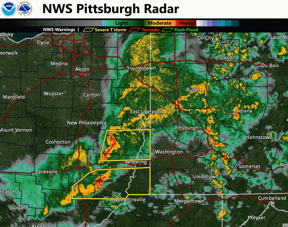
Radar
Header
 |
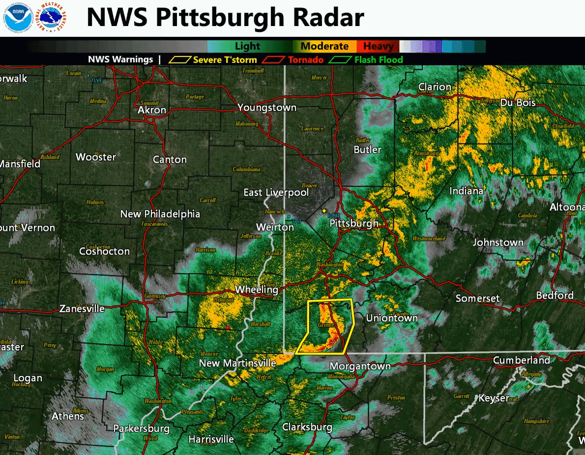 |
| Caption | Caption |
Storm Reports
Preliminary Local Storm Report...Summary
National Weather Service Pittsburgh PA
831 PM EST Wed Feb 28 2024
..TIME... ...EVENT... ...CITY LOCATION... ...LAT.LON...
..DATE... ....MAG.... ..COUNTY LOCATION..ST.. ...SOURCE....
..REMARKS..
0542 AM Hail St. Clairsville 40.08N 80.90W
02/28/2024 E1.00 inch Belmont OH Public
0630 AM Tstm Wnd Dmg Roseville 39.81N 82.07W
02/28/2024 Muskingum OH Emergency Mngr
EM reportings trees down in Roseville. Time estimated
based on radar.
0637 AM Tstm Wnd Dmg 1 N Adamsville 40.08N 81.88W
02/28/2024 Muskingum OH Emergency Mngr
EM reporting trees down near Adamsville. Time estimated
based on radar.
0642 AM Tstm Wnd Dmg 2 SE Chandlersville 39.88N 81.80W
02/28/2024 Muskingum OH Emergency Mngr
EM reported trees down along State Route 14 east of
Chandlersville. Time estimated based on radar.
0656 AM Tstm Wnd Dmg 3 S Pleasant City 39.86N 81.54W
02/28/2024 Noble OH Public
Report of trees down south of Pleasant City. Time
estimated based on radar.
0706 AM Tstm Wnd Dmg 2 NE Freeport 40.23N 81.24W
02/28/2024 Harrison OH Dept of Highways
DOT reported downed tree along State Route 799 at the 5
mile marker near Freeport. Time estimated based on
radar.
0720 AM Tstm Wnd Dmg 2 N Kerr 39.81N 81.14W
02/28/2024 Monroe OH Public
Public report picture showing multiple trees blown over
along County Road 2 in Monroe County. Time estimated
based on radar.
0720 AM Tstm Wnd Dmg 1 SE Miltonsburg 39.82N 81.15W
02/28/2024 Monroe OH Public
Public picture showing a line trees completely uprooted
with a couple others pine snapped. Time estimated based
on radar.
0720 AM Tstm Wnd Dmg Ozark 39.83N 81.08W
02/28/2024 Monroe OH Emergency Mngr
Emergency Management reporting multiple barns
destroyed, roofs blown off and power line issues around
Ozark in the southwest corner of Sunsbury Township. Time
estimated based on radar.
0724 AM Tstm Wnd Dmg Ozark 39.82N 81.08W
02/28/2024 Monroe OH Dept of Highways
DOT reporting multiple trees down along State Route 26
through Ozark. Time estimated based on radar.
0726 AM Tstm Wnd Dmg Beallsville 39.85N 81.04W
02/28/2024 Monroe OH Dept of Highways
DOT reports multiple trees down around Beallsville.
Time estimated based on radar.
0727 AM Tstm Wnd Dmg Harrisville 40.18N 80.89W
02/28/2024 Harrison OH Dept of Highways
DOT reported tree down along US 250 near Harrisville.
Time estimated based on radar.
0728 AM Tstm Wnd Dmg 1 SSE Crabapple 39.86N 80.98W
02/28/2024 Belmont OH Public
Report and photos of damage to barn along Pugh Ridge
Road. Time estimated based on radar.
0730 AM Tstm Wnd Dmg Armstrongs Mills 39.91N 80.93W
02/28/2024 Belmont OH Dept of Highways
DOT reported a downed tree along State Route 148
through Armstrongs Mills. Time estimated based on radar.
0740 AM Tstm Wnd Dmg 2 SE McKeefrey 39.88N 80.76W
02/28/2024 Marshall WV Emergency Mngr
Emergency Management reported down trees on roadway.
Time estimated based on radar.
0740 AM Tstm Wnd Dmg Grave Creek 39.87N 80.72W
02/28/2024 Marshall WV Emergency Mngr
Emergency Management reported down trees on roadway.
Time estimated based on radar.
0741 AM Tstm Wnd Dmg 1 NE McKeefrey 39.91N 80.78W
02/28/2024 Marshall WV Emergency Mngr
Emergency Management reported down trees on roadway.
Time estimated based on radar.
0742 AM Tstm Wnd Dmg 1 SE Moundsville 39.91N 80.72W
02/28/2024 Marshall WV Emergency Mngr
Emergency Management reported down trees on roadway.
Time estimated based on radar.
0744 AM Tstm Wnd Dmg Moundsville 39.92N 80.74W
02/28/2024 Marshall WV Dept of Highways
DOT reported downed trees in Moundsville. Time
estimated based on radar.
0744 AM Tstm Wnd Dmg 1 SE Moundsville 39.91N 80.72W
02/28/2024 Marshall WV Emergency Mngr
Emergency Management reported down trees on roadway.
Time estimated based on radar.
0750 AM Tstm Wnd Dmg 2 WSW Big Run 39.79N 80.60W
02/28/2024 Marshall WV Emergency Mngr
Emergency Management reported down trees on roadway.
Time estimated based on radar.
0801 AM Tstm Wnd Dmg Aleppo 39.82N 80.45W
02/28/2024 Greene PA Dept of Highways
DOT reporting downed trees over much of Greene County.
Location and time estimated based on radar.
0813 AM Tstm Wnd Dmg 1 SSE East View 39.89N 80.23W
02/28/2024 Greene PA Emergency Mngr
Report of tree down blocking one lane of State Route 21
just west of Oak Forest Road. Time estimated based on
radar.
0815 AM Tstm Wnd Dmg Waynesburg 39.90N 80.19W
02/28/2024 Greene PA Dept of Highways
DOT reporting downed trees over much of Greene County.
Location and time estimated based on radar.
0815 AM Tstm Wnd Dmg Spraggs 39.78N 80.22W
02/28/2024 Greene PA Dept of Highways
DOT reporting downed trees over much of Greene County.
Location and time estimated based on radar.
0823 AM Tstm Wnd Dmg 1 W Khedive 39.88N 80.05W
02/28/2024 Greene PA Emergency Mngr
REport of trees knocking electrical wires down onto the
road. Tree is also blocking Mohr Road. Time estimated
based on radar.
0828 AM Tstm Wnd Dmg Fairdale 39.89N 79.97W
02/28/2024 Greene PA Emergency Mngr
Report of tree blown down on house with no injuries.
Time estimated based on radar.
0839 AM Non-Tstm Wnd Gst Morgantown Airport 39.65N 79.92W
02/28/2024 M46 mph Monongalia WV ASOS
0845 AM Tstm Wnd Dmg Uniontown 39.90N 79.72W
02/28/2024 Fayette PA Public
Photo of large pine down on Lincoln Street. Time
estimated based on radar.
0855 AM Non-Tstm Wnd Gst Connellsville Airport 39.96N 79.66W
02/28/2024 M46 mph Fayette PA AWOS
1000 AM Non-Tstm Wnd Gst 5 E Canaan Heights 39.11N 79.35W
02/28/2024 M53 mph Tucker WV Mesonet
0229 PM Non-Tstm Wnd Gst Pittsburgh Intl Airport 40.50N 80.27W
02/28/2024 M46 mph Allegheny PA ASOS
0233 PM Non-Tstm Wnd Gst DuBois Airport 41.17N 78.90W
02/28/2024 M47 mph Jefferson PA ASOS
0322 PM Non-Tstm Wnd Dmg Rachel 39.52N 80.30W
02/28/2024 Marion WV 911 Call Center
Tree down on lines
0323 PM Non-Tstm Wnd Dmg 2 NW Connellsville 40.04N 79.62W
02/28/2024 Fayette PA Trained Spotter
Several trees and power lines down
0349 PM Non-Tstm Wnd Gst Pittsburgh Intl Airport 40.50N 80.27W
02/28/2024 M52 mph Allegheny PA ASOS
0401 PM Non-Tstm Wnd Gst Pittsburgh Intl Airport 40.50N 80.27W
02/28/2024 M46 mph Allegheny PA ASOS
0403 PM Non-Tstm Wnd Dmg Parsons 39.09N 79.68W
02/28/2024 Tucker WV 911 Call Center
Tree and power lines down. Tree fell on a church.
0410 PM Non-Tstm Wnd Gst 5 E Canaan Heights 39.11N 79.35W
02/28/2024 M58 mph Tucker WV Mesonet
0504 PM Non-Tstm Wnd Dmg Worthington 39.46N 80.26W
02/28/2024 Marion WV 911 Call Center
TREE DOWN
0555 PM Non-Tstm Wnd Dmg 2 SSW Silver Lake 39.23N 79.51W
02/28/2024 Preston WV 911 Call Center
TREE DOWN BLOCKING THE ROAD AT SLAUBAUGH AND SENECA
TRAIL
Rain Reports
Public Information Statement
Spotter Reports
National Weather Service Pittsburgh PA
354 PM EST Wed Feb 28 2024
The following are unofficial observations taken during the past 24
hours for the storm that has been affecting our region. Appreciation
is extended to highway departments, cooperative observers, Skywarn
spotters and media for these reports. This summary also is available
on our home page at weather.gov/pittsburgh
*********STORM TOTAL RAINFALL (AT LEAST 0.40 INCH)**********
LOCATION TOTAL TIME/DATE COMMENTS
RAINFALL
MEASURED
(inches)
| OHIO | |||||
| ..Belmont County... | |||||
| St. Clairsville | 0.54 | 1233 | PM | 2/28 | CWOP |
| ..Carroll County... | |||||
| 2 NE Leesville | 1.51 | 715 | AM | 2/28 | HADS |
| Magnolia | 0.79 | 1215 | PM | 2/28 | HADS |
| Carrollton | 0.51 | 715 | AM | 2/28 | CWOP |
| ..Columbiana County... | |||||
| 2 N Wellsville | 0.73 | 800 | AM | 2/28 | CoCoRaHS |
| 4 N Wellsville | 0.71 | 902 | AM | 2/28 | CoCoRaHS |
| 1 W Washingtonville | 0.49 | 1245 | PM | 2/28 | HADS |
| Columbiana | 0.40 | 1247 | PM | 2/28 | CWOP |
| ..Coshocton County... | |||||
| Woodbury Wildlife Ar | 1.03 | 700 | AM | 2/28 | IFLOWS |
| 3 SE Conesville | 0.70 | 1245 | PM | 2/28 | HADS |
| ..Guernsey County... | |||||
| 2 E Senecaville | 0.79 | 1215 | PM | 2/28 | HADS |
| 1 E Cambridge | 0.60 | 800 | AM | 2/28 | CoCoRaHS |
| 1 NE Pleasant City | 0.55 | 700 | AM | 2/28 | HADS |
| 3 SE Kimbolton | 0.48 | 1245 | PM | 2/28 | HADS |
| Pleasant City | 0.48 | 1225 | PM | 2/28 | IFLOWS |
| ..Harrison County... | |||||
| Cadiz | 0.65 | 1215 | PM | 2/28 | HADS |
| ..Jefferson County... | |||||
| 2 WNW Steubenville | 0.41 | 700 | AM | 2/28 | CoCoRaHS |
| ..Monroe County... | |||||
| Merrell Ridge | 0.72 | 1232 | PM | 2/28 | RAWS |
| Antioch | 0.60 | 1255 | PM | 2/28 | IFLOWS |
| ..Muskingum County... | |||||
| 5 SSW Concord | 0.60 | 830 | AM | 2/28 | CoCoRaHS |
| Zanesville Airport | 0.49 | 1253 | PM | 2/28 | ASOS |
| 4 W Zanesville | 0.49 | 724 | AM | 2/28 | AWS |
| ..Tuscarawas County... | |||||
| 1 S Uhrichsville | 1.25 | 700 | AM | 2/28 | HADS |
| 1 NW Dennison | 0.77 | 700 | AM | 2/28 | Co-Op Observer |
| WNW Carmichaels | 0.71 | 700 | AM | 2/28 | CoCoRaHS |
| New Philadelphia | 0.68 | 715 | AM | 2/28 | CWOP |
| 1 N Uhrichsville | 0.68 | 700 | AM | 2/28 | CoCoRaHS |
| New Philadelphia Air | 0.59 | 658 | AM | 2/28 | ASOS |
| 6 WSW New Philadelph | 0.58 | 800 | AM | 2/28 | CoCoRaHS |
| 5 WNW Dover | 0.57 | 700 | AM | 2/28 | CoCoRaHS |
| 3 N New Philadelphia | 0.43 | 1215 | PM | 2/28 | HADS |
| 2 SE Beach City | 0.41 | 1215 | PM | 2/28 | HADS |
| PENNSYLVANIA | |||||
| ..Allegheny County... | |||||
| 2 NW Allison Park | 0.93 | 900 | AM | 2/28 | CoCoRaHS |
| 3 WNW Tarentum | 0.83 | 800 | AM | 2/28 | CoCoRaHS |
| Natrona Heights | 0.72 | 717 | AM | 2/28 | CWOP |
| Dawson | 0.65 | 1240 | PM | 2/28 | CWOP |
| 2 SW Bridgeville | 0.64 | 1250 | PM | 2/28 | AWS |
| 1 SW Bridgeville | 0.63 | 815 | AM | 2/28 | CoCoRaHS |
| 1 WSW Plum | 0.63 | 1255 | PM | 2/28 | AWS |
| Pittsburgh | 0.63 | 1245 | PM | 2/28 | CWOP |
| ENE Harrison Townshi | 0.60 | 500 | AM | 2/28 | CoCoRaHS |
| 2 WNW Imperial | 0.55 | 800 | AM | 2/28 | CoCoRaHS |
| Emsworth | 0.53 | 1250 | PM | 2/28 | AWS |
| 3 NW Pittsburgh | 0.51 | 700 | AM | 2/28 | CoCoRaHS |
| 1 S Acmetonia | 0.51 | 600 | AM | 2/28 | Co-Op Observer |
| 8 ENE Pittsburgh | 0.50 | 800 | AM | 2/28 | CoCoRaHS |
| Imperial | 0.48 | 1245 | PM | 2/28 | CWOP |
| 1 ENE Verona | 0.48 | 700 | AM | 2/28 | CoCoRaHS |
| Moon Township | 0.47 | 1248 | PM | 2/28 | CWOP |
| Carnegie | 0.47 | 1249 | PM | 2/28 | CWOP |
| West Mifflin | 0.47 | 1253 | PM | 2/28 | AWOS |
| Braddock Lock And Da | 0.47 | 600 | AM | 2/28 | Co-Op Observer |
| Pittsburgh Intl Airp | 0.46 | 1251 | PM | 2/28 | ASOS |
| 2 SE South Fayette | 0.45 | 700 | AM | 2/28 | CoCoRaHS |
| 2 SW Pittsburgh | 0.43 | 830 | AM | 2/28 | CoCoRaHS |
| 2 NNE Pittsburgh | 0.42 | 700 | AM | 2/28 | CoCoRaHS |
| 7 NE Pittsburgh | 0.42 | 700 | AM | 2/28 | CoCoRaHS |
| 1 NE Gibsonia | 0.41 | 520 | AM | 2/28 | CoCoRaHS |
| 3 SE Monroeville | 0.40 | 700 | AM | 2/28 | CoCoRaHS |
| ..Armstrong County... | |||||
| 1 NNE New Kensington | 1.19 | 1242 | PM | 2/28 | CWOP |
| 6 SW Kittanning | 1.01 | 715 | AM | 2/28 | CoCoRaHS |
| 3 NNW Shelocta | 0.91 | 700 | AM | 2/28 | CoCoRaHS |
| 3 NW Dayton | 0.85 | 1245 | PM | 2/28 | HADS |
| 4 S Lenape Heights | 0.82 | 700 | AM | 2/28 | Co-Op Observer |
| 1 SSW Kittanning | 0.63 | 700 | AM | 2/28 | CoCoRaHS |
| 6 N Vandergrift | 0.63 | 700 | AM | 2/28 | CoCoRaHS |
| West Kittanning | 0.63 | 700 | AM | 2/28 | HADS |
| 4 NW Dayton | 0.56 | 600 | AM | 2/28 | Co-Op Observer |
| ..Beaver County... | |||||
| Baden | 1.01 | 1247 | PM | 2/28 | CWOP |
| Freedom | 0.82 | 1248 | PM | 2/28 | CWOP |
| 1 NW Harshaville | 0.74 | 1254 | PM | 2/28 | AWS |
| 6 W Beaver | 0.67 | 700 | AM | 2/28 | CoCoRaHS |
| Fombell | 0.60 | 1247 | PM | 2/28 | CWOP |
| 2 WSW Zelienople | 0.58 | 1250 | PM | 2/28 | AWS |
| Economy | 0.57 | 700 | AM | 2/28 | CoCoRaHS |
| Zelienople Airport | 0.44 | 1255 | PM | 2/28 | AWOS |
| ..Butler County... | |||||
| N Cabot | 1.01 | 720 | AM | 2/28 | CoCoRaHS |
| 2 NE Sarver | 0.98 | 515 | AM | 2/28 | CoCoRaHS |
| 1 SW Meridian | 0.94 | 800 | AM | 2/28 | CoCoRaHS |
| 2 WNW Cabot | 0.75 | 700 | AM | 2/28 | CoCoRaHS |
| 2 W Butler | 0.73 | 700 | AM | 2/28 | CoCoRaHS |
| Butler County Airpor | 0.61 | 1256 | PM | 2/28 | AWOS |
| Karns City | 0.55 | 715 | AM | 2/28 | CWOP |
| 5 SE Slippery Rock | 0.55 | 919 | AM | 2/28 | CoCoRaHS |
| 1 N Harmony | 0.46 | 720 | AM | 2/28 | AWS |
| 7 WNW Butler | 0.44 | 1040 | AM | 2/28 | CoCoRaHS |
| ..Clarion County... | |||||
| 6 NW Sigel | 1.18 | 700 | AM | 2/28 | USGS |
| Leeper | 1.16 | 715 | AM | 2/28 | CWOP |
| 3 SW Clarion | 0.85 | 700 | AM | 2/28 | Co-Op Observer |
| 5 N Hawthorn | 0.52 | 600 | AM | 2/28 | CoCoRaHS |
| ..Fayette County... | |||||
| 1 E Belle Vernon | 0.65 | 700 | AM | 2/28 | CoCoRaHS |
| 2 W Juniata | 0.57 | 1245 | PM | 2/28 | HADS |
| Connellsville Airpor | 0.42 | 1235 | PM | 2/28 | AWOS |
| 1 ENE Farmington | 0.42 | 700 | AM | 2/28 | CoCoRaHS |
| ..Forest County... | |||||
| 5 W Marienville | 1.12 | 620 | AM | 2/28 | CoCoRaHS |
| 5 ENE Tionesta | 0.91 | 730 | AM | 2/28 | CoCoRaHS |
| 7 SSE Tionesta | 0.89 | 700 | AM | 2/28 | CoCoRaHS |
| 1 S Tionesta | 0.67 | 1245 | PM | 2/28 | HADS |
| ..Greene County... | |||||
| Waynesburg | 0.52 | 1249 | PM | 2/28 | CWOP |
| ..Indiana County... | |||||
| 4 NNW Glen Campbell | 1.35 | 1250 | PM | 2/28 | AWS |
| Marion Center | 0.74 | 700 | AM | 2/28 | HADS |
| Yellow Creek State P | 0.64 | 1243 | PM | 2/28 | RAWS |
| 4 E Saltsburg | 0.58 | 1230 | PM | 2/28 | HADS |
| Shelocta | 0.57 | 700 | AM | 2/28 | CoCoRaHS |
| 2 ESE Chevy Chase He | 0.48 | 700 | AM | 2/28 | CoCoRaHS |
| ..Jefferson County... | |||||
| Punxsutawney | 0.90 | 1245 | PM | 2/28 | CWOP |
| 1 SE Punxsutawney | 0.86 | 1215 | PM | 2/28 | HADS |
| DuBois Airport | 0.84 | 1253 | PM | 2/28 | ASOS |
| Brookville | 0.51 | 700 | AM | 2/28 | HADS |
| ..Lawrence County... | |||||
| 5 NNW Portersville | 0.47 | 700 | AM | 2/28 | CoCoRaHS |
| 1 NNE New Castle | 0.40 | 730 | AM | 2/28 | CoCoRaHS |
| ..Mercer County... | |||||
| 2 SW Hermitage | 0.89 | 915 | AM | 2/28 | CoCoRaHS |
| 1 E Sharpsville | 0.64 | 1245 | PM | 2/28 | HADS |
| 2 SE West Middlesex | 0.59 | 700 | AM | 2/28 | CoCoRaHS |
| Sandy Lake | 0.41 | 1215 | PM | 2/28 | HADS |
| ..Venango County... | |||||
| 1 NNE Seneca | 1.15 | 700 | AM | 2/28 | CoCoRaHS |
| 8 ENE Kennerdell | 0.99 | 800 | AM | 2/28 | CoCoRaHS |
| 1 NW Rouseville | 0.96 | 645 | AM | 2/28 | HADS |
| 1 E Franklin | 0.85 | 800 | AM | 2/28 | Co-Op Observer |
| Franklin Airport | 0.84 | 1256 | PM | 2/28 | AWOS |
| 1 E Cooperstown | 0.82 | 545 | AM | 2/28 | CoCoRaHS |
| 6 SW Titusville | 0.71 | 700 | AM | 2/28 | CoCoRaHS |
| NW Reno | 0.69 | 530 | AM | 2/28 | CoCoRaHS |
| 1 SSW Franklin | 0.68 | 615 | AM | 2/28 | CoCoRaHS |
| ..Washington County... | |||||
| Avella | 0.67 | 1245 | PM | 2/28 | HADS |
| Washington County Ai | 0.60 | 1256 | PM | 2/28 | AWOS |
| 5 E Avella | 0.47 | 745 | AM | 2/28 | CoCoRaHS |
| SSE Dunlevy | 0.46 | 800 | AM | 2/28 | CoCoRaHS |
| ..Westmoreland County.. | . | ||||
| Irwin | 0.95 | 1240 | PM | 2/28 | CWOP |
| 1 NW Ligonier | 0.87 | 1245 | PM | 2/28 | HADS |
| 1 SW Leechburg | 0.82 | 700 | AM | 2/28 | CoCoRaHS |
| 1 E Ligonier | 0.72 | 900 | AM | 2/28 | CoCoRaHS |
| Apollo | 0.65 | 1247 | PM | 2/28 | CWOP |
| 1 SW Laughlintown | 0.58 | 800 | AM | 2/28 | Co-Op Observer |
| 3 ESE Smithton | 0.53 | 700 | AM | 2/28 | CoCoRaHS |
| 5 SW Latrobe | 0.53 | 800 | AM | 2/28 | CoCoRaHS |
| 3 SE White Oak | 0.50 | 1250 | PM | 2/28 | AWS |
| 1 SW New Stanton | 0.50 | 729 | AM | 2/28 | Co-Op Observer |
| 1 NNW Webster | 0.49 | 700 | AM | 2/28 | CoCoRaHS |
| 3 WSW Smithton | 0.48 | 807 | AM | 2/28 | CoCoRaHS |
| 2 S Saltsburg | 0.45 | 700 | AM | 2/28 | Co-Op Observer |
| 1 NW Jeannette | 0.44 | 1230 | PM | 2/28 | HADS |
| SE Ligonier | 0.44 | 700 | AM | 2/28 | CoCoRaHS |
| 1 S Irwin | 0.42 | 700 | AM | 2/28 | CoCoRaHS |
| 3 NNW New Stanton | 0.42 | 730 | AM | 2/28 | CoCoRaHS |
| WEST VIRGINIA | |||||
| ..Brooke County... | |||||
| Archer Heights | 0.52 | 1205 | PM | 2/28 | IFLOWS |
| ..Hancock County... | |||||
| 2 E New Cumberland | 1.04 | 800 | AM | 2/28 | IFLOWS |
| Kings Creek | 0.56 | 1255 | PM | 2/28 | IFLOWS |
| 1 E Chester | 0.56 | 725 | AM | 2/28 | IFLOWS |
| ..Marion County... | |||||
| 2 N Rivesville | 0.42 | 600 | AM | 2/28 | CoCoRaHS |
| ..Marshall County... | |||||
| 4 NW Littleton | 0.76 | 1230 | PM | 2/28 | IFLOWS |
| ..Monongalia County... | |||||
| MORGANTOWN | 1.08 | 1248 | PM | 2/28 | CWOP |
| Morgantown Airport | 0.85 | 1253 | PM | 2/28 | ASOS |
| 1 SE Westover | 0.85 | 1215 | PM | 2/28 | HADS |
| Morgantown | 0.74 | 1247 | PM | 2/28 | CWOP |
| 4 NE Rivesville | 0.66 | 1200 | PM | 2/28 | IFLOWS |
| 6 WSW Morgantown | 0.49 | 700 | AM | 2/28 | CoCoRaHS |
| 6 SW Morgantown | 0.48 | 700 | AM | 2/28 | CoCoRaHS |
| Morgantown Dam | 0.41 | 700 | AM | 2/28 | Co-Op Observer |
| ..Ohio County... | |||||
| Wheeling | 0.68 | 1245 | PM | 2/28 | CWOP |
| Wheeling Airport | 0.61 | 1253 | PM | 2/28 | ASOS |
| 2 E Bethlehem | 0.57 | 1215 | PM | 2/28 | HADS |
| ..Preston County... | |||||
| Cheat River | 0.79 | 1245 | PM | 2/28 | HADS |
| Bruceton Mills | 0.74 | 1215 | PM | 2/28 | HADS |
| 9 SE Bruceton Mills | 0.74 | 900 | AM | 2/28 | CoCoRaHS |
| 5 NNE Terra Alta | 0.54 | 800 | AM | 2/28 | CoCoRaHS |
| 3 S Bruceton Mills | 0.40 | 700 | AM | 2/28 | CoCoRaHS |
| ..Tucker County... | |||||
| Parsons | 0.67 | 1246 | PM | 2/28 | CWOP |
| 4 S Canaan Valley | 0.50 | 1245 | PM | 2/28 | HADS |
| 3 NW Thomas | 0.44 | 700 | AM | 2/28 | IFLOWS |
| 3 S Canaan Hgts | 0.40 | 1235 | PM | 2/28 | IFLOWS |
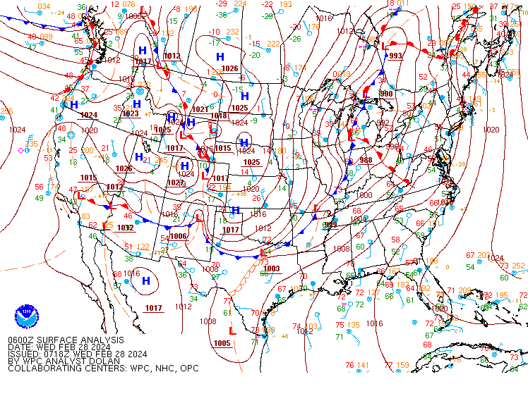
Environment
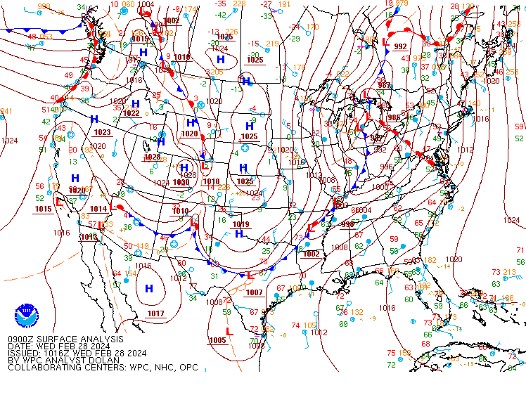
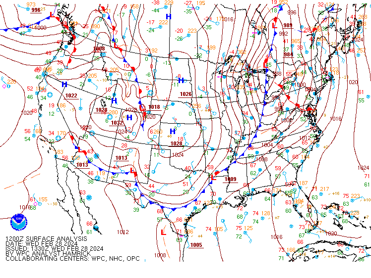
Surface Analysis Maps from WPC.
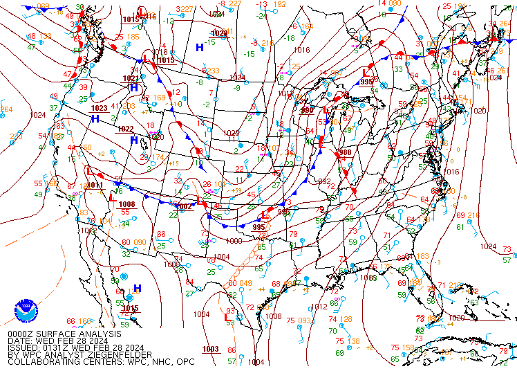 |
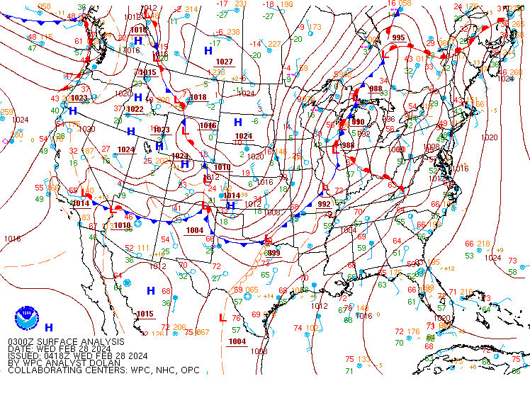 |
 |
| SFC 20240228 00Z | SFC 20240228 03Z | SFC 20240228 06Z |
 |
 |
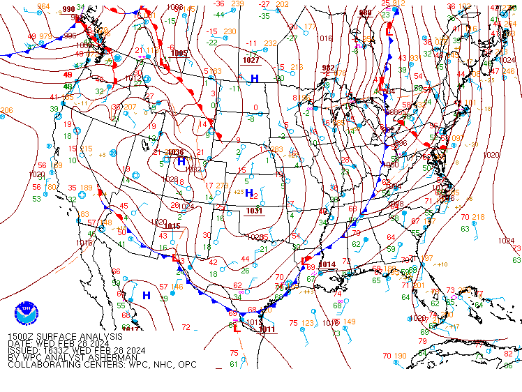 |
| SFC 20240228 09Z | SFC 20240228 12Z | SFC 20240228 15Z |
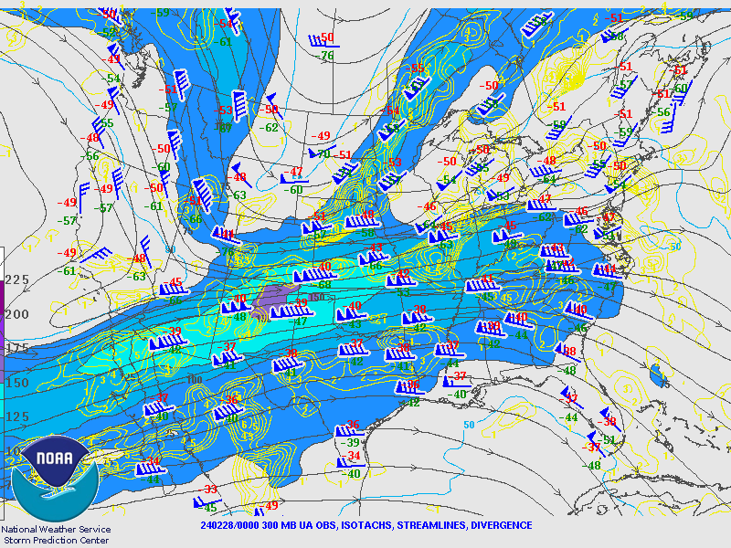
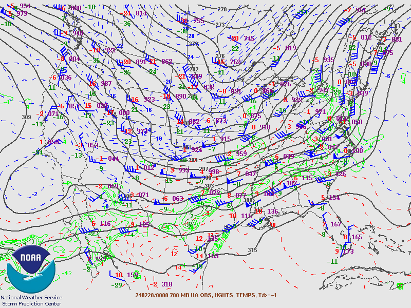
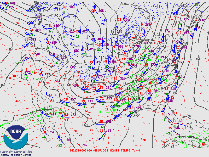
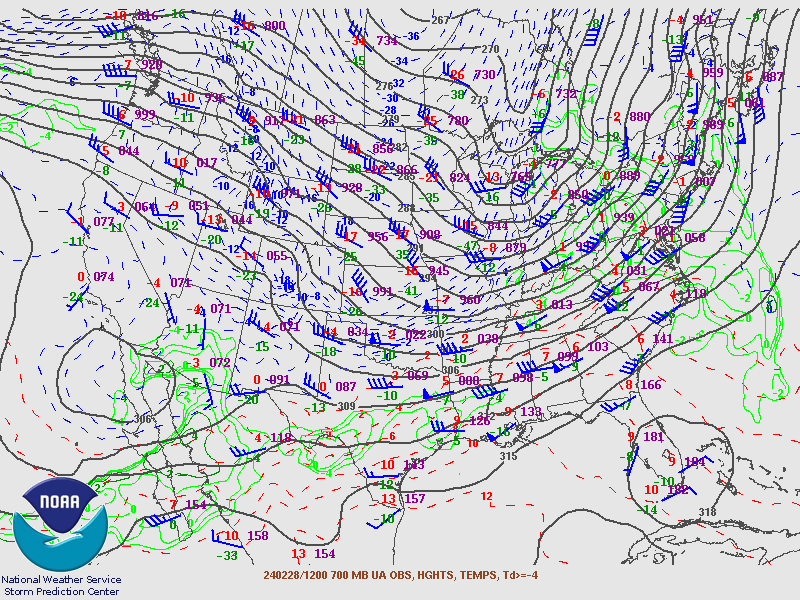
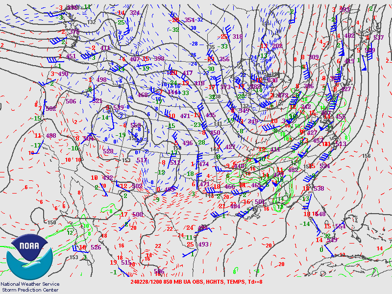
Upper Maps from SPC.
February 28th 2024 00Z Maps.
 |
 |
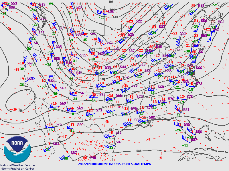 |
| 250MB | 300MB | 500MB |
 |
 |
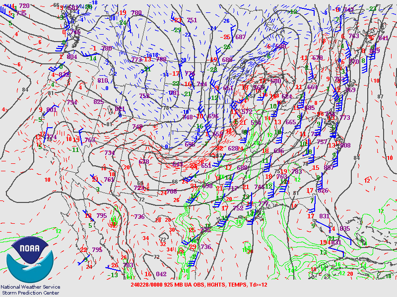 |
| 700MB | 850MB | 925MB |
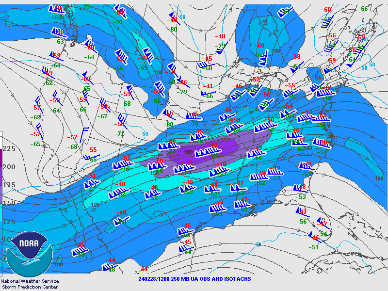
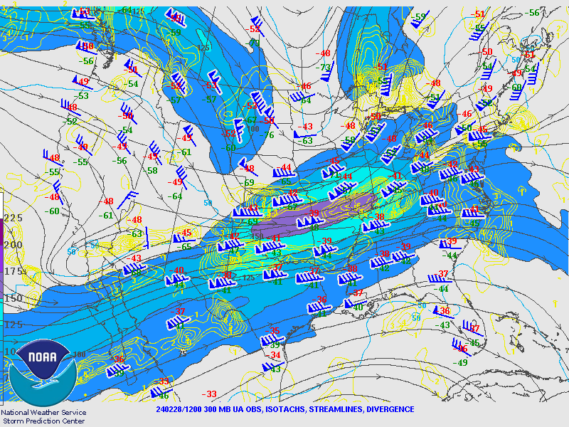
February 28th 2024 12Z Maps.
 |
 |
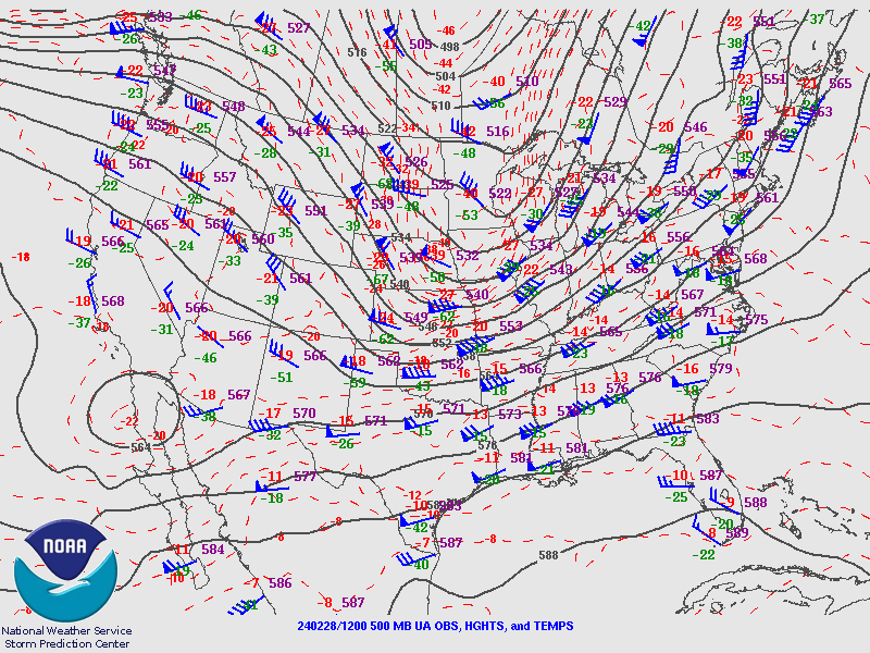 |
| 250MB | 300MB | 500MB |
 |
 |
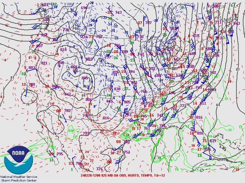 |
| 700MB | 850MB | 925MB |
Upper Air Soundings from PIT.
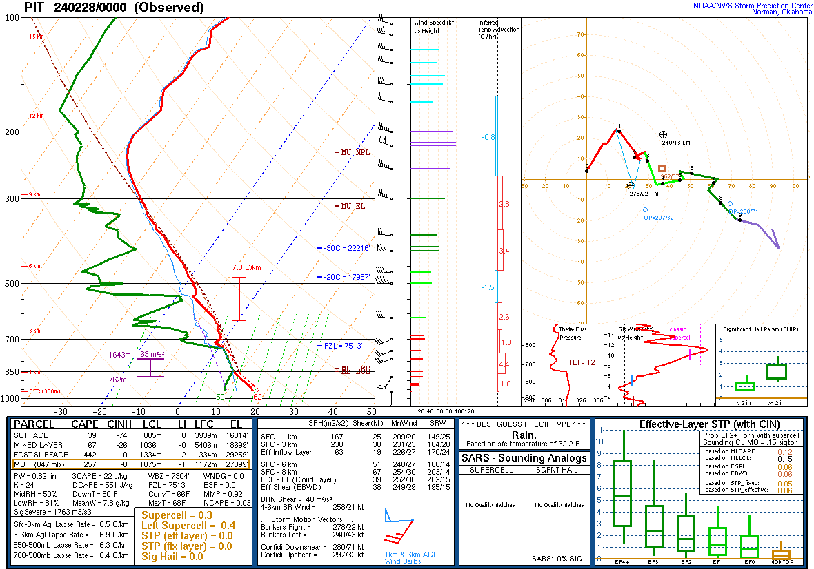 |
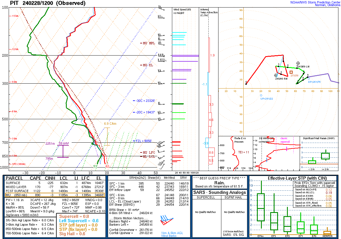 |
| 022824 00Z Sounding | 022824 12Z Sounding |
 |
Media use of NWS Web News Stories is encouraged! Please acknowledge the NWS as the source of any news information accessed from this site. |
|