Overview
| This powerful low pressure system set the stage for an unprecedented push of cold air and wintry weather in the southern plains before pivoting and lifting north into the OH Valley. As the low lifted northeast through western OH and IN, the warm air pushed into southwest PA and WV changing the snow over to freezing rain and eventually rain by Monday evening. This change over significantly cut down on the snowfall totals across the region but lead to numerous issues with accretion of ice on road surfaces and walk ways. Locations in central OH remain either snow or freezing rain through the entire event resulting hazardous travel and numerous power outages. In addition, some ice accretion in the higher terrain in Westmoreland and Fayette counties lead to some fallen trees and power outages as well. | 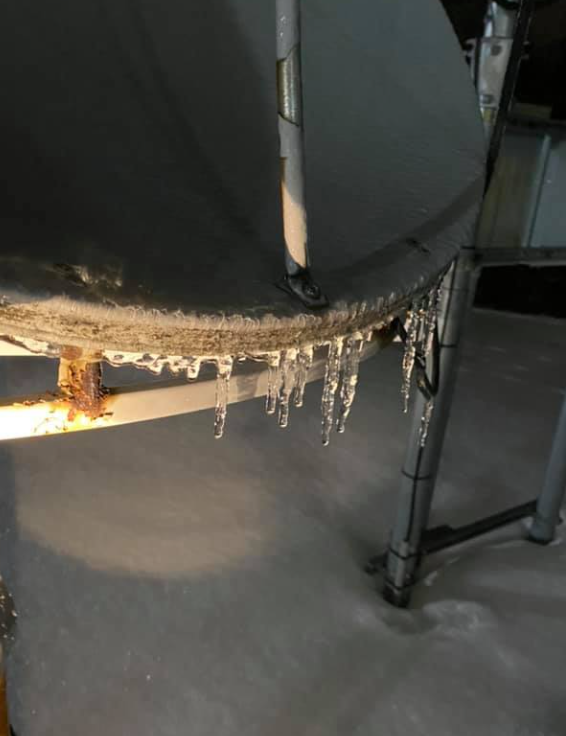 National Weather Service Pittsburgh, Moon Township, PA |
Snow/Ice

Photos & Video
Header
 |
 |
 |
 |
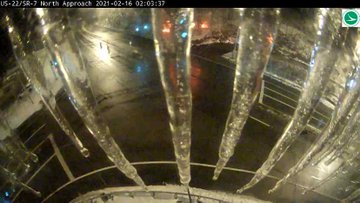
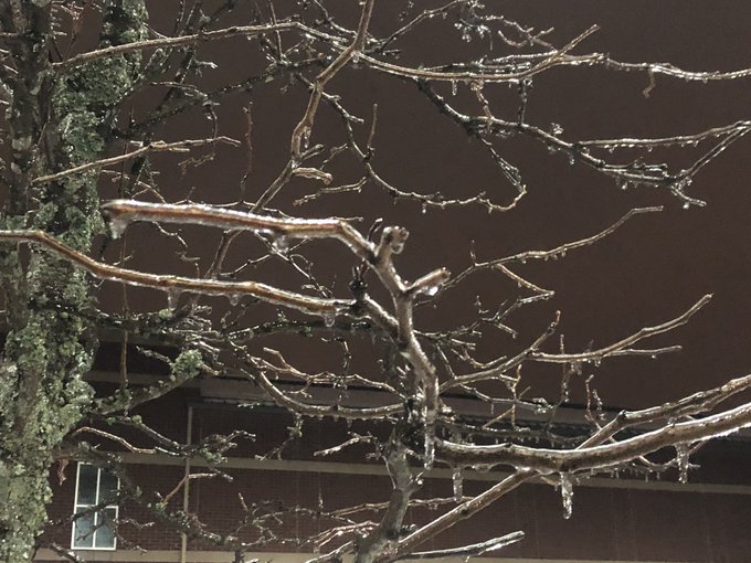
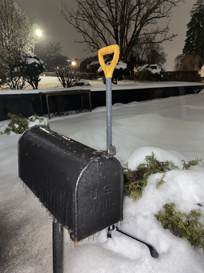
| Jefferson Co, OH (Credit: OHDOT) |
Summer Hills, PA (Credit: Danielle Dozer) |
Pleasant Hills, PA (Credit: Lisa McBlair) |
Steubenville, OH (Credit: OHDOT) |
Storm Reports
PUBLIC INFORMATION STATEMENT
SPOTTER REPORTS
NATIONAL WEATHER SERVICE PITTSBURGH PA
1021 AM EST TUE FEB 16 2021

THE FOLLOWING ARE UNOFFICIAL OBSERVATIONS TAKEN DURING THE PAST 31
HOURS FOR THE STORM THAT HAS BEEN AFFECTING OUR REGION. APPRECIATION
IS EXTENDED TO HIGHWAY DEPARTMENTS, COOPERATIVE OBSERVERS, SKYWARN
SPOTTERS AND MEDIA FOR THESE REPORTS. THIS SUMMARY ALSO IS AVAILABLE
ON OUR HOME PAGE AT WEATHER.GOV/PITTSBURGH

********************STORM TOTAL SNOWFALL********************

LOCATION                TOTAL      TIME/DATE  COMMENTS
                     SNOWFALL       MEASURED
                     (INCHES)

OHIO

...CARROLL COUNTY...
  LEESVILLE               1.8   928 AM  2/15  TRAINED SPOTTER

...COLUMBIANA COUNTY...
  ENE HANOVERTON          2.0   400 AM  2/16  COCORAHS
  4 N WELLSVILLE          0.3   900 AM  2/15  COCORAHS

...COSHOCTON COUNTY...
  1 W WEST LAFAYETTE      1.5   900 AM  2/16  TRAINED SPOTTER
  COSHOCTON               1.0   919 PM  2/15  TRAINED SPOTTER
  4 SE COSHOCTON          1.0  1000 AM  2/15  PUBLIC
  2 NNE FRESNO            1.0   800 AM  2/15  COCORAHS

...GUERNSEY COUNTY...
  1 S QUAKER CITY         0.5   705 AM  2/16  PUBLIC

...HARRISON COUNTY...
  5 NW BLOOMINGDALE       1.0   900 AM  2/15  COCORAHS

...JEFFERSON COUNTY...
  STEUBENVILLE            1.5  1112 AM  2/15  BROADCAST MEDIA
  1 WSW MOUNT PLEASANT    1.4   700 AM  2/16  COCORAHS
  2 WNW STEUBENVILLE      1.0   730 AM  2/15  COCORAHS
  1 WNW WINTERSVILLE      0.6   800 AM  2/15  COCORAHS
  1 NW WINTERSVILLE       0.6   800 AM  2/15  PUBLIC
  UNIONPORT               0.1   527 PM  2/15  FACEBOOK

...MUSKINGUM COUNTY...
  5 N ZANESVILLE          3.0   902 AM  2/15  TWITTER
  1 W RIX MILLS           2.5   830 AM  2/16  PUBLIC
  1 SE NORWICH            2.0   700 AM  2/16  COCORAHS
  DRESDEN                 1.2   931 AM  2/15  FACEBOOK
  ZANESVILLE              0.5   844 PM  2/15  BROADCAST MEDIA
  2 S NORWICH             0.3   530 PM  2/15  PUBLIC

...TUSCARAWAS COUNTY...
  WNW CARMICHAELS         2.6   800 AM  2/16  COCORAHS
  NEW PHILADELPHIA        2.5   634 AM  2/16  PUBLIC
  2 N NEWCOMERSTOWN       1.9  1231 PM  2/15  PUBLIC
  4 S NEW PHILADELPHIA    1.7   845 AM  2/15  PUBLIC
  1 NW DENNISON           1.4   700 AM  2/15  CO-OP OBSERVER
  2 S STONE CREEK         1.2   700 AM  2/15  PUBLIC
  1 N UHRICHSVILLE        0.8   700 AM  2/16  COCORAHS
  5 WNW DOVER             0.3   700 AM  2/15  COCORAHS
  7 SE MINERAL CITY       0.2   800 AM  2/16  COCORAHS

PENNSYLVANIA

...ALLEGHENY COUNTY...
  2 S MCCANDLESS TOWNS    3.1   700 AM  2/16  COCORAHS
  N SPRINGDALE            2.7   700 AM  2/16  TRAINED SPOTTER
  S NATRONA HEIGHTS       1.9  1045 AM  2/15  TRAINED SPOTTER
  2 SE SOUTH FAYETTE      1.8   700 AM  2/16  COCORAHS
  NE TARENTUM             1.5  1135 AM  2/15  PUBLIC
  2 NE MOON               1.5   700 AM  2/16  CO-OP OBSERVER
  1 N CARNOT-MOON         1.4  1024 AM  2/15  OFFICIAL NWS OBS
  1 SW BRIDGEVILLE        1.3   700 AM  2/16  COCORAHS
  2 NW JEFFERSON          1.2  1000 PM  2/15  COCORAHS
  6 E PITTSBURGH          1.0   300 PM  2/15  COCORAHS
  2 E ELIZABETH           1.0  1050 AM  2/15  TRAINED SPOTTER
  PENN HILLS              0.8  1050 AM  2/15  TRAINED SPOTTER
  3 NE PITTSBURGH         0.8   923 AM  2/15  COCORAHS
  BETHEL PARK             0.8   930 AM  2/15  PUBLIC
  4 NNW PITTSBURGH        0.5   600 AM  2/16  COCORAHS
  1 NE GIBSONIA           0.4   640 AM  2/16  COCORAHS
  2 S HARRISON TOWNSHI    0.2   700 AM  2/16  HADS
  2 W INDIANOLA             T   600 PM  2/15  TRAINED SPOTTER

...ARMSTRONG COUNTY...
  SCHENLEY                2.5   700 AM  2/16  CO-OP OBSERVER
  1 SSW KITTANNING        1.5   700 AM  2/16  COCORAHS
  4 NW DAYTON             0.5   600 AM  2/16  CO-OP OBSERVER
  4 S LENAPE HEIGHTS      0.1   700 AM  2/15  CO-OP OBSERVER

...BEAVER COUNTY...
  6 W BEAVER              0.5   700 AM  2/15  COCORAHS
  3 NE NEW BRIGHTON       0.5   800 AM  2/16  COCORAHS

...BUTLER COUNTY...
  1 S SLIPPERY ROCK       2.4   630 AM  2/16  CO-OP OBSERVER
  2 NNE FOX RUN           2.0   600 AM  2/16  COCORAHS
  EAST BUTLER             1.5  1000 AM  2/15  TRAINED SPOTTER
  W BUTLER                1.5  1127 AM  2/15  PUBLIC
  2 WNW CABOT             1.5   700 AM  2/16  COCORAHS
  1 E VALENCIA            1.5  1105 AM  2/15  1.5 INCH ROUND 1 TOTAL
  2 W BUTLER              1.4   700 AM  2/16  COCORAHS
  3 NW CABOT              1.1  1120 AM  2/15  TRAINED SPOTTER
  NE EAST BUTLER          1.0   945 AM  2/15  TRAINED SPOTTER
  3 WSW BUTLER            0.9   700 AM  2/15  COCORAHS
  ZELIENOPLE              0.2   707 AM  2/16  TRAINED SPOTTER
  5 SE SLIPPERY ROCK      0.1   800 AM  2/16  COCORAHS

...CLARION COUNTY...
  MARBLE                  1.0  1100 AM  2/15  PUBLIC
  SW MARBLE               1.0   200 PM  2/15  PUBLIC
  4 WNW SUMMERVILLE       0.4   800 AM  2/15  COCORAHS

...FAYETTE COUNTY...
  1 ENE FARMINGTON        0.3   700 AM  2/16  COCORAHS

...FOREST COUNTY...
  5 W MARIENVILLE         1.3   330 PM  2/15  COCORAHS
  7 SSE TIONESTA          1.2   700 AM  2/16  COCORAHS

...LAWRENCE COUNTY...
  4 S VOLANT              2.4   825 AM  2/16  PUBLIC

...MERCER COUNTY...
  SHARPSVILLE             1.0   935 PM  2/15  PUBLIC
  2 SW HERMITAGE          0.5   915 AM  2/15  COCORAHS
  2 S WEST MIDDLESEX      0.4   915 AM  2/15  COCORAHS

...VENANGO COUNTY...
  1 NNE SENECA            1.4   700 AM  2/16  COCORAHS
  1 E COOPERSTOWN         1.0   700 AM  2/16  COCORAHS
  1 SSW FRANKLIN          1.0   600 AM  2/16  COCORAHS
  6 SW TITUSVILLE         0.7   700 AM  2/16  COCORAHS
  1 E FRANKLIN            0.6   800 AM  2/16  CO-OP OBSERVER
  2 E EMLENTON            0.2   700 AM  2/16  PUBLIC

...WASHINGTON COUNTY...
  1 WNW VENETIA           1.5   800 AM  2/15  COCORAHS
  WASHINGTON              1.2  1202 PM  2/15  1.2 ROUND 1 TOTAL
  1 NNW FINLEYVILLE       1.1   700 AM  2/16  COCORAHS
  WNW BULGER              0.7   845 AM  2/15  COCORAHS
  1 W CANONSBURG          0.3   700 AM  2/15  COCORAHS
  4 NW CANONSBURG         0.1   700 AM  2/15  COCORAHS

...WESTMORELAND COUNTY...
  NEW KENSINGTON          2.0   941 AM  2/15  TRAINED SPOTTER
  2 NW DONEGAL            2.0   700 AM  2/15  CO-OP OBSERVER
  1 W NEW KENSINGTON      1.3   700 AM  2/16  COCORAHS
  YOUNGWOOD               1.0  1212 PM  2/15  TRAINED SPOTTER
  3 E NORTH WASHINGTON    1.0   700 AM  2/16  CO-OP OBSERVER
  1 SW LEECHBURG          1.0   800 AM  2/16  COCORAHS
  NNE ADAMSBURG           0.6  1130 AM  2/15  COCORAHS
  ADAMSBURG               0.6  1130 AM  2/15  PUBLIC

WEST VIRGINIA

...MONONGALIA COUNTY...
  6 SW MORGANTOWN         0.1   700 AM  2/16  COCORAHS

...OHIO COUNTY...
  WHEELING                1.5   954 AM  2/15  1.5 INCH AS OF 10 AM
  4 NNE VALLEY GROVE      0.9   700 AM  2/16  COCORAHS

...PRESTON COUNTY...
  5 NNE TERRA ALTA        0.2   800 AM  2/16  COCORAHS

...WETZEL COUNTY...
  7 E NEW MARTINSVILLE    0.3   800 AM  2/16  COCORAHS


**********************STORM TOTAL ICE***********************

LOCATION                TOTAL      TIME/DATE  COMMENTS
                          ICE       MEASURED
                     (INCHES)

OHIO

...BELMONT COUNTY...
  ST. CLAIRSVILLE        0.10   830 PM  2/15  PICTURE PROVIDED

...CARROLL COUNTY...
  LEESVILLE              0.12   730 AM  2/16  TRAINED SPOTTER

...COLUMBIANA COUNTY...
  4 N WELLSVILLE         0.20   800 AM  2/16  BROADCAST MEDIA
  SALEM                  0.10   300 AM  2/16  FACEBOOK

...COSHOCTON COUNTY...
  1 W WEST LAFAYETTE     0.10   900 AM  2/16  TRAINED SPOTTER

...GUERNSEY COUNTY...
  1 S QUAKER CITY        0.25   705 AM  2/16  PUBLIC

...JEFFERSON COUNTY...
  1 S EMERSON            0.30   810 AM  2/16  COCORAHS
  1 NW WINTERSVILLE      0.10   800 AM  2/16  PUBLIC
  WINTERSVILLE           0.10   749 PM  2/15  FACEBOOK
  ADENA                     T   527 PM  2/15  FACEBOOK
  TORONTO                   T   525 PM  2/15  FACEBOOK

...MONROE COUNTY...
  BEALLSVILLE            0.30   945 AM  2/16  TRAINED SPOTTER
  GRAYSVILLE             0.10   526 PM  2/15  FACEBOOK

...MUSKINGUM COUNTY...
  1 W RIX MILLS          0.15   830 AM  2/16  PUBLIC
  4 E PLEASANT GROVE     0.04   200 AM  2/16  ASOS
  2 S NORWICH               T   530 PM  2/15  PUBLIC

...TUSCARAWAS COUNTY...
  1 N ZOAR               0.25   736 AM  2/16  TWITTER
  NEW PHILADELPHIA       0.20   634 AM  2/16  PUBLIC
  2 S STONE CREEK           T   715 AM  2/16  PUBLIC

PENNSYLVANIA

...ALLEGHENY COUNTY...
  WEXFORD                0.20   500 AM  2/16  NWS EMPLOYEE
  1 N CARNOT-MOON        0.20   600 AM  2/16  OFFICIAL NWS OBS
  CARRICK                0.15   600 AM  2/16  FACEBOOK
  1 SSE INGOMAR          0.15  1100 PM  2/15  NWS EMPLOYEE
  SUMMER HILL            0.10   937 PM  2/15  BROADCAST MEDIA
  N SPRINGDALE           0.10   700 AM  2/16  TRAINED SPOTTER
  MCCANDLESS TOWNSHIP    0.10   723 AM  2/16  TWITTER
  SPRINGDALE             0.10  1000 PM  2/15  TWITTER
  2 S PENN HILLS         0.10   930 PM  2/15  TRAINED SPOTTER
  2 W INDIANOLA          0.09   600 PM  2/15  TRAINED SPOTTER
  1 W WEST MIFFLIN       0.08  1122 PM  2/15  ASOS
  2 ESE PITTSBURGH INT   0.08   404 AM  2/16  ASOS
  2 E ELIZABETH             T  1050 AM  2/15  TRAINED SPOTTER

...BEAVER COUNTY...
  N ROCHESTER            0.20   900 PM  2/15  PUBLIC
  BEAVER FALLS           0.15   930 PM  2/15  TWITTER
  BLACKHAWK              0.10  1100 PM  2/15  PUBLIC
  OHIOVILLE              0.05   753 AM  2/16  TWITTER
  NORTH SEWICKLEY           T   525 PM  2/15  PUBLIC

...BUTLER COUNTY...
  PROSPECT               0.18   730 AM  2/16  TRAINED SPOTTER
  ZELIENOPLE             0.12   707 AM  2/16  TRAINED SPOTTER
  BUTLER                 0.10   748 PM  2/15  FACEBOOK
  MARS                      T   720 PM  2/15  TWITTER
  NE EAST BUTLER            T   700 AM  2/16  PUBLIC
  CABOT                     T   851 PM  2/15  TRAINED SPOTTER

...CLARION COUNTY...
  CLARION                   T   745 PM  2/15  TRAINED SPOTTER

...FAYETTE COUNTY...
  MASONTOWN              0.01   839 AM  2/15  FACEBOOK
  BROWNSVILLE               T   500 PM  2/15  PUBLIC

...GREENE COUNTY...
  WAYNESBURG             0.01   752 AM  2/15  FACEBOOK
  BOBTOWN                0.01  1000 PM  2/15  GLAZE FORMING ON TREES.

...JEFFERSON COUNTY...
  TIMBLIN                0.20  1130 PM  2/15  TRAINED SPOTTER
  5 WNW FALLS CREEK      0.20   300 AM  2/16  ASOS

...LAWRENCE COUNTY...
  NEW CASTLE                T   728 PM  2/15  TWITTER

...MERCER COUNTY...
  SHARPSVILLE               T   815 AM  2/16  PUBLIC

...VENANGO COUNTY...
  2 E EMLENTON           0.25   700 AM  2/16  PUBLIC

...WASHINGTON COUNTY...
  BULGER                 0.12  1025 PM  2/15  TRAINED SPOTTER
  CECIL                  0.05   854 PM  2/15  PICTURE PROVIDED.
  FINLEYVILLE               T   700 PM  2/15  TWITTER

...WESTMORELAND COUNTY...
  YOUNGWOOD                 T  1100 AM  2/15  TRAINED SPOTTER
  MONESSEN                  T   522 PM  2/15  FACEBOOK
  2 N BELLE VERNON          T   806 AM  2/15  TWITTER

WEST VIRGINIA

...MARION COUNTY...
  3 SE COLFAX            0.10   900 AM  2/15  PUBLIC

...MARSHALL COUNTY...
  MOUNDSVILLE            0.10   856 PM  2/15  PICTURE PROVIDED.

...MONONGALIA COUNTY...
  6 SW MORGANTOWN        0.10   806 PM  2/15  CORRECTED
  2 ENE MORGANTOWN       0.07   753 PM  2/15  ASOS
  MORGANTOWN                T   720 PM  2/15  TWITTER

...OHIO COUNTY...
  3 W WEST LIBERTY       0.18   347 AM  2/16  ASOS
  WOODSDALE                 T   522 PM  2/15  FACEBOOK
  WHEELING                  T   523 PM  2/15  FACEBOOK

...WETZEL COUNTY...
  HUNDRED                0.05   751 PM  2/15  COUNTY OFFICIAL

&&

*****METADATA*****
:2/15/2021,  928 AM, OH, CARROLL, LEESVILLE, , , 40.4509, -81.2096, SNOW, 1.8, INCH, TRAINED SPOTTER, STORM TOTAL SNOW,
:2/16/2021,  400 AM, OH, COLUMBIANA, HANOVERTON, , ENE, 40.7570, -80.9292, SNOW, 2.0, INCH, COCORAHS, STORM TOTAL SNOW,
:2/15/2021,  900 AM, OH, COLUMBIANA, WELLSVILLE, 4, N, 40.6644, -80.6424, SNOW, 0.3, INCH, COCORAHS, STORM TOTAL SNOW,
:2/16/2021,  900 AM, OH, COSHOCTON, WEST LAFAYETTE, 1, W, 40.2763, -81.7683, SNOW, 1.5, INCH, TRAINED SPOTTER, STORM TOTAL SNOW,
:2/15/2021,  919 PM, OH, COSHOCTON, COSHOCTON, , , 40.2637, -81.8496, SNOW, 1.0, INCH, TRAINED SPOTTER, STORM TOTAL SNOW,
:2/15/2021, 1000 AM, OH, COSHOCTON, COSHOCTON, 4, SE, 40.2391, -81.8103, SNOW, 1.0, INCH, PUBLIC, STORM TOTAL SNOW,
:2/15/2021,  800 AM, OH, COSHOCTON, FRESNO, 2, NNE, 40.3583, -81.7193, SNOW, 1.0, INCH, COCORAHS, STORM TOTAL SNOW,
:2/16/2021,  705 AM, OH, GUERNSEY, QUAKER CITY, 1, S, 39.9586, -81.2905, SNOW, 0.5, INCH, PUBLIC, STORM TOTAL SNOW,
:2/15/2021,  900 AM, OH, HARRISON, BLOOMINGDALE, 5, NW, 40.4049, -80.8783, SNOW, 1.0, INCH, COCORAHS, STORM TOTAL SNOW,
:2/15/2021, 1112 AM, OH, JEFFERSON, STEUBENVILLE, , , 40.3670, -80.6466, SNOW, 1.5, INCH, BROADCAST MEDIA, STORM TOTAL SNOW,
:2/16/2021,  700 AM, OH, JEFFERSON, MOUNT PLEASANT, 1, WSW, 40.1650, -80.8229, SNOW, 1.4, INCH, COCORAHS, STORM TOTAL SNOW,
:2/15/2021,  730 AM, OH, JEFFERSON, STEUBENVILLE, 2, WNW, 40.3760, -80.6820, SNOW, 1.0, INCH, COCORAHS, STORM TOTAL SNOW,
:2/15/2021,  800 AM, OH, JEFFERSON, WINTERSVILLE, 1, WNW, 40.3843, -80.7176, SNOW, 0.6, INCH, COCORAHS, STORM TOTAL SNOW,
:2/15/2021,  800 AM, OH, JEFFERSON, WINTERSVILLE, 1, NW, 40.3845, -80.7177, SNOW, 0.6, INCH, PUBLIC, STORM TOTAL SNOW,
:2/15/2021,  527 PM, OH, JEFFERSON, UNIONPORT, , , 40.3581, -80.8456, SNOW, 0.1, INCH, FACEBOOK, STORM TOTAL SNOW,
:2/15/2021,  902 AM, OH, MUSKINGUM, ZANESVILLE, 5, N, 40.0248, -82.0120, SNOW, 3.0, INCH, TWITTER, STORM TOTAL SNOW,
:2/16/2021,  830 AM, OH, MUSKINGUM, RIX MILLS, 1, W, 39.9237, 81.7592, SNOW, 2.5, INCH, PUBLIC, STORM TOTAL SNOW,
:2/16/2021,  700 AM, OH, MUSKINGUM, NORWICH, 1, SE, 39.9753, -81.7767, SNOW, 2.0, INCH, COCORAHS, STORM TOTAL SNOW,
:2/15/2021,  931 AM, OH, MUSKINGUM, DRESDEN, , , 40.1218, -82.0111, SNOW, 1.2, INCH, FACEBOOK, STORM TOTAL SNOW,
:2/15/2021,  844 PM, OH, MUSKINGUM, ZANESVILLE, , , 39.9524, -82.0120, SNOW, 0.5, INCH, BROADCAST MEDIA, STORM TOTAL SNOW,
:2/15/2021,  530 PM, OH, MUSKINGUM, NORWICH, 2, S, 39.9608, -81.8052, SNOW, 0.3, INCH, PUBLIC, STORM TOTAL SNOW,
:2/16/2021,  800 AM, OH, TUSCARAWAS, CARMICHAELS, , WNW, 40.5114, -81.6257, SNOW, 2.6, INCH, COCORAHS, STORM TOTAL SNOW,
:2/16/2021,  634 AM, OH, TUSCARAWAS, NEW PHILADELPHIA, , , 40.4600, 81.4100, SNOW, 2.5, INCH, PUBLIC, STORM TOTAL SNOW,
:2/15/2021, 1231 PM, OH, TUSCARAWAS, NEWCOMERSTOWN, 2, N, 40.3035, -81.5988, SNOW, 1.9, INCH, PUBLIC, STORM TOTAL SNOW,
:2/15/2021,  845 AM, OH, TUSCARAWAS, NEW PHILADELPHIA, 4, S, 40.4241, -81.4674, SNOW, 1.7, INCH, PUBLIC, STORM TOTAL SNOW,
:2/15/2021,  700 AM, OH, TUSCARAWAS, DENNISON, 1, NW, 40.4056, -81.3431, SNOW, 1.4, INCH, CO-OP OBSERVER, STORM TOTAL SNOW,
:2/15/2021,  700 AM, OH, TUSCARAWAS, STONE CREEK, 2, S, 40.3752, -81.5674, SNOW, 1.2, INCH, PUBLIC, STORM TOTAL SNOW,
:2/16/2021,  700 AM, OH, TUSCARAWAS, UHRICHSVILLE, 1, N, 40.4099, -81.3532, SNOW, 0.8, INCH, COCORAHS, STORM TOTAL SNOW,
:2/15/2021,  700 AM, OH, TUSCARAWAS, DOVER, 5, WNW, 40.5507, -81.5640, SNOW, 0.3, INCH, COCORAHS, STORM TOTAL SNOW,
:2/16/2021,  800 AM, OH, TUSCARAWAS, MINERAL CITY, 7, SE, 40.5205, -81.2769, SNOW, 0.2, INCH, COCORAHS, STORM TOTAL SNOW,
:2/16/2021,  700 AM, PA, ALLEGHENY, MCCANDLESS TOWNSHIP, 2, S, 40.5569, -80.0366, SNOW, 3.1, INCH, COCORAHS, STORM TOTAL SNOW,
:2/16/2021,  700 AM, PA, ALLEGHENY, SPRINGDALE, , N, 40.5500, 79.7800, SNOW, 2.7, INCH, TRAINED SPOTTER, STORM TOTAL SNOW,
:2/15/2021, 1045 AM, PA, ALLEGHENY, NATRONA HEIGHTS, , S, 40.6200, 79.7400, SNOW, 1.9, INCH, TRAINED SPOTTER, STORM TOTAL SNOW,
:2/16/2021,  700 AM, PA, ALLEGHENY, SOUTH FAYETTE, 2, SE, 40.3381, -80.1159, SNOW, 1.8, INCH, COCORAHS, STORM TOTAL SNOW,
:2/15/2021, 1135 AM, PA, ALLEGHENY, TARENTUM, , NE, 40.6071, -79.7556, SNOW, 1.5, INCH, PUBLIC, STORM TOTAL SNOW,
:2/16/2021,  700 AM, PA, ALLEGHENY, MOON, 2, NE, 40.5319, -80.2172, SNOW, 1.5, INCH, CO-OP OBSERVER, STORM TOTAL SNOW,
:2/15/2021, 1024 AM, PA, ALLEGHENY, CARNOT-MOON, 1, N, 40.5319, -80.2174, SNOW, 1.4, INCH, OFFICIAL NWS OBS, STORM TOTAL SNOW,
:2/16/2021,  700 AM, PA, ALLEGHENY, BRIDGEVILLE, 1, SW, 40.3417, -80.1229, SNOW, 1.3, INCH, COCORAHS, STORM TOTAL SNOW,
:2/15/2021, 1000 PM, PA, ALLEGHENY, JEFFERSON, 2, NW, 40.3131, -79.9523, SNOW, 1.2, INCH, COCORAHS, STORM TOTAL SNOW,
:2/15/2021,  300 PM, PA, ALLEGHENY, PITTSBURGH, 6, E, 40.4318, -79.8925, SNOW, 1.0, INCH, COCORAHS, STORM TOTAL SNOW,
:2/15/2021, 1050 AM, PA, ALLEGHENY, ELIZABETH, 2, E, 40.2701, -79.8472, SNOW, 1.0, INCH, TRAINED SPOTTER, STORM TOTAL SNOW,
:2/15/2021, 1050 AM, PA, ALLEGHENY, PENN HILLS, , , 40.4870, 79.7858, SNOW, 0.8, INCH, TRAINED SPOTTER, STORM TOTAL SNOW,
:2/15/2021,  923 AM, PA, ALLEGHENY, PITTSBURGH, 3, NE, 40.4684, -79.9295, SNOW, 0.8, INCH, COCORAHS, STORM TOTAL SNOW,
:2/15/2021,  930 AM, PA, ALLEGHENY, BETHEL PARK, , , 40.2998, -80.0349, SNOW, 0.8, INCH, PUBLIC, STORM TOTAL SNOW,
:2/16/2021,  600 AM, PA, ALLEGHENY, PITTSBURGH, 4, NNW, 40.4888, -80.0006, SNOW, 0.5, INCH, COCORAHS, STORM TOTAL SNOW,
:2/16/2021,  640 AM, PA, ALLEGHENY, GIBSONIA, 1, NE, 40.6405, -79.9506, SNOW, 0.4, INCH, COCORAHS, STORM TOTAL SNOW,
:2/16/2021,  700 AM, PA, ALLEGHENY, HARRISON TOWNSHIP, 2, S, 40.6153, -79.7186, SNOW, 0.2, INCH, HADS, STORM TOTAL SNOW,
:2/15/2021,  600 PM, PA, ALLEGHENY, INDIANOLA, 2, W, 40.5745, -79.8919, SNOW, T, INCH, TRAINED SPOTTER, STORM TOTAL SNOW,
:2/16/2021,  700 AM, PA, ARMSTRONG, SCHENLEY, , , 40.6842, -79.6681, SNOW, 2.5, INCH, CO-OP OBSERVER, STORM TOTAL SNOW,
:2/16/2021,  700 AM, PA, ARMSTRONG, KITTANNING, 1, SSW, 40.8095, -79.5306, SNOW, 1.5, INCH, COCORAHS, STORM TOTAL SNOW,
:2/16/2021,  600 AM, PA, ARMSTRONG, DAYTON, 4, NW, 40.9250, -79.2825, SNOW, 0.5, INCH, CO-OP OBSERVER, STORM TOTAL SNOW,
:2/15/2021,  700 AM, PA, ARMSTRONG, LENAPE HEIGHTS, 4, S, 40.7136, -79.5150, SNOW, 0.1, INCH, CO-OP OBSERVER, STORM TOTAL SNOW,
:2/15/2021,  700 AM, PA, BEAVER, BEAVER, 6, W, 40.7050, -80.4121, SNOW, 0.5, INCH, COCORAHS, STORM TOTAL SNOW,
:2/16/2021,  800 AM, PA, BEAVER, NEW BRIGHTON, 3, NE, 40.7694, -80.2729, SNOW, 0.5, INCH, COCORAHS, STORM TOTAL SNOW,
:2/16/2021,  630 AM, PA, BUTLER, SLIPPERY ROCK, 1, S, 41.0556, -80.0606, SNOW, 2.4, INCH, CO-OP OBSERVER, STORM TOTAL SNOW,
:2/16/2021,  600 AM, PA, BUTLER, FOX RUN, 2, NNE, 40.7239, -80.0706, SNOW, 2.0, INCH, COCORAHS, STORM TOTAL SNOW,
:2/15/2021, 1000 AM, PA, BUTLER, EAST BUTLER, , , 40.8786, -79.8476, SNOW, 1.5, INCH, TRAINED SPOTTER, STORM TOTAL SNOW,
:2/15/2021, 1127 AM, PA, BUTLER, BUTLER, , W, 40.8665, -79.8963, SNOW, 1.5, INCH, PUBLIC, STORM TOTAL SNOW,
:2/16/2021,  700 AM, PA, BUTLER, CABOT, 2, WNW, 40.7725, -79.7956, SNOW, 1.5, INCH, COCORAHS, STORM TOTAL SNOW,
:2/15/2021, 1105 AM, PA, BUTLER, VALENCIA, 1, E, 40.6757, -79.9776, SNOW, 1.5, INCH, TWITTER, STORM TOTAL SNOW, 1.5 INCH ROUND 1 TOTAL
:2/16/2021,  700 AM, PA, BUTLER, BUTLER, 2, W, 40.8640, -79.9260, SNOW, 1.4, INCH, COCORAHS, STORM TOTAL SNOW,
:2/15/2021, 1120 AM, PA, BUTLER, CABOT, 3, NW, 40.8075, -79.7738, SNOW, 1.1, INCH, TRAINED SPOTTER, STORM TOTAL SNOW,
:2/15/2021,  945 AM, PA, BUTLER, EAST BUTLER, , NE, 40.8752, -79.8408, SNOW, 1.0, INCH, TRAINED SPOTTER, STORM TOTAL SNOW,
:2/15/2021,  700 AM, PA, BUTLER, BUTLER, 3, WSW, 40.8483, -79.9557, SNOW, 0.9, INCH, COCORAHS, STORM TOTAL SNOW,
:2/16/2021,  707 AM, PA, BUTLER, ZELIENOPLE, , , 40.7801, -80.1024, SNOW, 0.2, INCH, TRAINED SPOTTER, STORM TOTAL SNOW,
:2/16/2021,  800 AM, PA, BUTLER, SLIPPERY ROCK, 5, SE, 41.0087, -80.0031, SNOW, 0.1, INCH, COCORAHS, STORM TOTAL SNOW,
:2/15/2021, 1100 AM, PA, CLARION, MARBLE, , , 41.3390, -79.4381, SNOW, 1.0, INCH, PUBLIC, STORM TOTAL SNOW,
:2/15/2021,  200 PM, PA, CLARION, MARBLE, , SW, 41.3400, 79.4400, SNOW, 1.0, INCH, PUBLIC, STORM TOTAL SNOW,
:2/15/2021,  800 AM, PA, CLARION, SUMMERVILLE, 4, WNW, 41.1301, -79.2638, SNOW, 0.4, INCH, COCORAHS, STORM TOTAL SNOW,
:2/16/2021,  700 AM, PA, FAYETTE, FARMINGTON, 1, ENE, 39.8100, -79.5576, SNOW, 0.3, INCH, COCORAHS, STORM TOTAL SNOW,
:2/15/2021,  330 PM, PA, FOREST, MARIENVILLE, 5, W, 41.4500, -79.1824, SNOW, 1.3, INCH, COCORAHS, STORM TOTAL SNOW,
:2/16/2021,  700 AM, PA, FOREST, TIONESTA, 7, SSE, 41.3940, -79.4131, SNOW, 1.2, INCH, COCORAHS, STORM TOTAL SNOW,
:2/16/2021,  825 AM, PA, LAWRENCE, VOLANT, 4, S, 41.0655, -80.2513, SNOW, 2.4, INCH, PUBLIC, STORM TOTAL SNOW,
:2/15/2021,  935 PM, PA, MERCER, SHARPSVILLE, , , 41.2731, -80.5065, SNOW, 1.0, INCH, PUBLIC, STORM TOTAL SNOW,
:2/15/2021,  915 AM, PA, MERCER, HERMITAGE, 2, SW, 41.1994, -80.4565, SNOW, 0.5, INCH, COCORAHS, STORM TOTAL SNOW,
:2/15/2021,  915 AM, PA, MERCER, WEST MIDDLESEX, 2, S, 41.1434, -80.4552, SNOW, 0.4, INCH, COCORAHS, STORM TOTAL SNOW,
:2/16/2021,  700 AM, PA, VENANGO, SENECA, 1, NNE, 41.3846, -79.6979, SNOW, 1.4, INCH, COCORAHS, STORM TOTAL SNOW,
:2/16/2021,  700 AM, PA, VENANGO, COOPERSTOWN, 1, E, 41.5007, -79.8497, SNOW, 1.0, INCH, COCORAHS, STORM TOTAL SNOW,
:2/16/2021,  600 AM, PA, VENANGO, FRANKLIN, 1, SSW, 41.3728, -79.8501, SNOW, 1.0, INCH, COCORAHS, STORM TOTAL SNOW,
:2/16/2021,  700 AM, PA, VENANGO, TITUSVILLE, 6, SW, 41.5670, -79.7639, SNOW, 0.7, INCH, COCORAHS, STORM TOTAL SNOW,
:2/16/2021,  800 AM, PA, VENANGO, FRANKLIN, 1, E, 41.3903, -79.8217, SNOW, 0.6, INCH, CO-OP OBSERVER, STORM TOTAL SNOW,
:2/16/2021,  700 AM, PA, VENANGO, EMLENTON, 2, E, 41.2508, -79.6526, SNOW, 0.2, INCH, PUBLIC, STORM TOTAL SNOW,
:2/15/2021,  800 AM, PA, WASHINGTON, VENETIA, 1, WNW, 40.2522, -80.0539, SNOW, 1.5, INCH, COCORAHS, STORM TOTAL SNOW,
:2/15/2021, 1202 PM, PA, WASHINGTON, WASHINGTON, , , 40.1743, -80.2474, SNOW, 1.2, INCH, TRAINED SPOTTER, STORM TOTAL SNOW, 1.2 ROUND 1 TOTAL
:2/16/2021,  700 AM, PA, WASHINGTON, FINLEYVILLE, 1, NNW, 40.2633, -80.0113, SNOW, 1.1, INCH, COCORAHS, STORM TOTAL SNOW,
:2/15/2021,  845 AM, PA, WASHINGTON, BULGER, , WNW, 40.3794, -80.3314, SNOW, 0.7, INCH, COCORAHS, STORM TOTAL SNOW,
:2/15/2021,  700 AM, PA, WASHINGTON, CANONSBURG, 1, W, 40.2623, -80.2001, SNOW, 0.3, INCH, COCORAHS, STORM TOTAL SNOW,
:2/15/2021,  700 AM, PA, WASHINGTON, CANONSBURG, 4, NW, 40.3005, -80.2385, SNOW, 0.1, INCH, COCORAHS, STORM TOTAL SNOW,
:2/15/2021,  941 AM, PA, WESTMORELAND, NEW KENSINGTON, , , 40.5699, -79.7508, SNOW, 2.0, INCH, TRAINED SPOTTER, STORM TOTAL SNOW,
:2/15/2021,  700 AM, PA, WESTMORELAND, DONEGAL, 2, NW, 40.1347, -79.4072, SNOW, 2.0, INCH, CO-OP OBSERVER, STORM TOTAL SNOW,
:2/16/2021,  700 AM, PA, WESTMORELAND, NEW KENSINGTON, 1, W, 40.5698, -79.7612, SNOW, 1.3, INCH, COCORAHS, STORM TOTAL SNOW,
:2/15/2021, 1212 PM, PA, WESTMORELAND, YOUNGWOOD, , , 40.2437, -79.5811, SNOW, 1.0, INCH, TRAINED SPOTTER, STORM TOTAL SNOW,
:2/16/2021,  700 AM, PA, WESTMORELAND, NORTH WASHINGTON, 3, E, 40.5100, -79.5458, SNOW, 1.0, INCH, CO-OP OBSERVER, STORM TOTAL SNOW,
:2/16/2021,  800 AM, PA, WESTMORELAND, LEECHBURG, 1, SW, 40.6153, -79.6214, SNOW, 1.0, INCH, COCORAHS, STORM TOTAL SNOW,
:2/15/2021, 1130 AM, PA, WESTMORELAND, NNE ADAMSBURG, , , 40.3127, -79.6538, SNOW, 0.6, INCH, COCORAHS, STORM TOTAL SNOW,
:2/15/2021, 1130 AM, PA, WESTMORELAND, ADAMSBURG, , , 40.3125, -79.6537, SNOW, 0.6, INCH, PUBLIC, STORM TOTAL SNOW,
:2/16/2021,  700 AM, WV, MONONGALIA, MORGANTOWN, 6, SW, 39.5662, -80.0149, SNOW, 0.1, INCH, COCORAHS, STORM TOTAL SNOW,
:2/15/2021,  954 AM, WV, OHIO, WHEELING, , , 40.0751, -80.6970, SNOW, 1.5, INCH, BROADCAST MEDIA, STORM TOTAL SNOW, 1.5 INCH AS OF 10 AM
:2/16/2021,  700 AM, WV, OHIO, VALLEY GROVE, 4, NNE, 40.1380, -80.5435, SNOW, 0.9, INCH, COCORAHS, STORM TOTAL SNOW,
:2/16/2021,  800 AM, WV, PRESTON, TERRA ALTA, 5, NNE, 39.5102, -79.5102, SNOW, 0.2, INCH, COCORAHS, STORM TOTAL SNOW,
:2/16/2021,  800 AM, WV, WETZEL, NEW MARTINSVILLE, 7, E, 39.6490, -80.7382, SNOW, 0.3, INCH, COCORAHS, STORM TOTAL SNOW,
:2/15/2021,  830 PM, OH, BELMONT, ST. CLAIRSVILLE, , , 40.0781, -80.8990, ICE, 0.10, INCH, FACEBOOK, STORM TOTAL ICE ACCRUAL, PICTURE PROVIDED
:2/16/2021,  730 AM, OH, CARROLL, LEESVILLE, , , 40.4509, -81.2096, ICE, 0.12, INCH, TRAINED SPOTTER, STORM TOTAL ICE ACCRUAL,
:2/16/2021,  800 AM, OH, COLUMBIANA, WELLSVILLE, 4, N, 40.6606, -80.6563, ICE, 0.20, INCH, BROADCAST MEDIA, STORM TOTAL ICE ACCRUAL,
:2/16/2021,  300 AM, OH, COLUMBIANA, SALEM, , , 40.9026, -80.8537, ICE, 0.10, INCH, FACEBOOK, STORM TOTAL ICE ACCRUAL,
:2/16/2021,  900 AM, OH, COSHOCTON, WEST LAFAYETTE, 1, W, 40.2763, -81.7683, ICE, 0.10, INCH, TRAINED SPOTTER, STORM TOTAL ICE ACCRUAL,
:2/16/2021,  705 AM, OH, GUERNSEY, QUAKER CITY, 1, S, 39.9586, -81.2905, ICE, 0.25, INCH, PUBLIC, STORM TOTAL ICE ACCRUAL,
:2/16/2021,  810 AM, OH, JEFFERSON, EMERSON, 1, S, 40.1650, -80.8229, ICE, 0.30, INCH, COCORAHS, STORM TOTAL ICE ACCRUAL,
:2/16/2021,  800 AM, OH, JEFFERSON, WINTERSVILLE, 1, NW, 40.3845, -80.7177, ICE, 0.10, INCH, PUBLIC, STORM TOTAL ICE ACCRUAL,
:2/15/2021,  749 PM, OH, JEFFERSON, WINTERSVILLE, , , 40.3790, -80.7066, ICE, 0.10, INCH, FACEBOOK, STORM TOTAL ICE ACCRUAL,
:2/15/2021,  527 PM, OH, JEFFERSON, ADENA, , , 40.2164, -80.8763, ICE, T, INCH, FACEBOOK, STORM TOTAL ICE ACCRUAL,
:2/15/2021,  525 PM, OH, JEFFERSON, TORONTO, , , 40.4589, -80.6063, ICE, T, INCH, FACEBOOK, STORM TOTAL ICE ACCRUAL,
:2/16/2021,  945 AM, OH, MONROE, BEALLSVILLE, , , 39.8484, -81.0368, ICE, 0.30, INCH, TRAINED SPOTTER, STORM TOTAL ICE ACCRUAL,
:2/15/2021,  526 PM, OH, MONROE, GRAYSVILLE, , , 39.6611, -81.1711, ICE, 0.10, INCH, FACEBOOK, STORM TOTAL ICE ACCRUAL,
:2/16/2021,  830 AM, OH, MUSKINGUM, RIX MILLS, 1, W, 39.9237, 81.7592, ICE, 0.15, INCH, PUBLIC, STORM TOTAL ICE ACCRUAL,
:2/16/2021,  200 AM, OH, MUSKINGUM, PLEASANT GROVE, 4, E, 39.9461, -81.8931, ICE, 0.04, INCH, ASOS, STORM TOTAL ICE ACCRUAL,
:2/15/2021,  530 PM, OH, MUSKINGUM, NORWICH, 2, S, 39.9608, -81.8052, ICE, T, INCH, PUBLIC, STORM TOTAL ICE ACCRUAL,
:2/16/2021,  736 AM, OH, TUSCARAWAS, ZOAR, 1, N, 40.6285, -81.4243, ICE, 0.25, INCH, TWITTER, STORM TOTAL ICE ACCRUAL,
:2/16/2021,  634 AM, OH, TUSCARAWAS, NEW PHILADELPHIA, , , 40.4600, 81.4100, ICE, 0.20, INCH, PUBLIC, STORM TOTAL ICE ACCRUAL,
:2/16/2021,  715 AM, OH, TUSCARAWAS, STONE CREEK, 2, S, 40.3752, -81.5674, ICE, T, INCH, PUBLIC, STORM TOTAL ICE ACCRUAL,
:2/16/2021,  500 AM, PA, ALLEGHENY, WEXFORD, , , 40.6300, -80.0500, ICE, 0.20, INCH, NWS EMPLOYEE, STORM TOTAL ICE ACCRUAL,
:2/16/2021,  600 AM, PA, ALLEGHENY, CARNOT-MOON, 1, N, 40.5319, -80.2174, ICE, 0.20, INCH, OFFICIAL NWS OBS, STORM TOTAL ICE ACCRUAL,
:2/16/2021,  600 AM, PA, ALLEGHENY, CARRICK, , , 40.3965, -79.9903, ICE, 0.15, INCH, FACEBOOK, STORM TOTAL ICE ACCRUAL,
:2/15/2021, 1100 PM, PA, ALLEGHENY, INGOMAR, 1, SSE, 40.5686, -80.0556, ICE, 0.15, INCH, NWS EMPLOYEE, STORM TOTAL ICE ACCRUAL,
:2/15/2021,  937 PM, PA, ALLEGHENY, SUMMER HILL, , , 40.4919, -80.0060, ICE, 0.10, INCH, BROADCAST MEDIA, STORM TOTAL ICE ACCRUAL,
:2/16/2021,  700 AM, PA, ALLEGHENY, SPRINGDALE, , N, 40.5500, 79.7800, ICE, 0.10, INCH, TRAINED SPOTTER, STORM TOTAL ICE ACCRUAL,
:2/16/2021,  723 AM, PA, ALLEGHENY, MCCANDLESS TOWNSHIP, , , 40.5835, -80.0300, ICE, 0.10, INCH, TWITTER, STORM TOTAL ICE ACCRUAL,
:2/15/2021, 1000 PM, PA, ALLEGHENY, SPRINGDALE, , , 40.5396, -79.7820, ICE, 0.10, INCH, TWITTER, STORM TOTAL ICE ACCRUAL,
:2/15/2021,  930 PM, PA, ALLEGHENY, PENN HILLS, 2, S, 40.4514, -79.8425, ICE, 0.10, INCH, TRAINED SPOTTER, STORM TOTAL ICE ACCRUAL,
:2/15/2021,  600 PM, PA, ALLEGHENY, INDIANOLA, 2, W, 40.5745, -79.8919, ICE, 0.09, INCH, TRAINED SPOTTER, STORM TOTAL ICE ACCRUAL,
:2/15/2021, 1122 PM, PA, ALLEGHENY, WEST MIFFLIN, 1, W, 40.3551, -79.9214, ICE, 0.08, INCH, ASOS, STORM TOTAL ICE ACCRUAL,
:2/16/2021,  404 AM, PA, ALLEGHENY, PITTSBURGH INTL AIRPORT, 2, ESE, 40.4846, -80.2145, ICE, 0.08, INCH, ASOS, STORM TOTAL ICE ACCRUAL,
:2/15/2021, 1050 AM, PA, ALLEGHENY, ELIZABETH, 2, E, 40.2701, -79.8472, ICE, T, INCH, TRAINED SPOTTER, STORM TOTAL ICE ACCRUAL,
:2/15/2021,  900 PM, PA, BEAVER, ROCHESTER, , N, 40.7060, -80.2851, ICE, 0.20, INCH, PUBLIC, STORM TOTAL ICE ACCRUAL,
:2/15/2021,  930 PM, PA, BEAVER, BEAVER FALLS, , , 40.7609, -80.3224, ICE, 0.15, INCH, TWITTER, STORM TOTAL ICE ACCRUAL,
:2/15/2021, 1100 PM, PA, BEAVER, BLACKHAWK, , , 40.7649, -80.4022, ICE, 0.10, INCH, PUBLIC, STORM TOTAL ICE ACCRUAL,
:2/16/2021,  753 AM, PA, BEAVER, OHIOVILLE, , , 40.6829, -80.4773, ICE, 0.05, INCH, TWITTER, STORM TOTAL ICE ACCRUAL,
:2/15/2021,  525 PM, PA, BEAVER, NORTH SEWICKLEY, , , 40.7801, -80.2984, ICE, T, INCH, PUBLIC, STORM TOTAL ICE ACCRUAL,
:2/16/2021,  730 AM, PA, BUTLER, PROSPECT, , , 40.9007, -80.0496, ICE, 0.18, INCH, TRAINED SPOTTER, STORM TOTAL ICE ACCRUAL,
:2/16/2021,  707 AM, PA, BUTLER, ZELIENOPLE, , , 40.7801, -80.1024, ICE, 0.12, INCH, TRAINED SPOTTER, STORM TOTAL ICE ACCRUAL,
:2/15/2021,  748 PM, PA, BUTLER, BUTLER, , , 40.8619, -79.8967, ICE, 0.10, INCH, FACEBOOK, STORM TOTAL ICE ACCRUAL,
:2/15/2021,  720 PM, PA, BUTLER, MARS, , , 40.6966, -80.0141, ICE, T, INCH, TWITTER, STORM TOTAL ICE ACCRUAL,
:2/16/2021,  700 AM, PA, BUTLER, EAST BUTLER, , NE, 40.8752, -79.8408, ICE, T, INCH, PUBLIC, STORM TOTAL ICE ACCRUAL,
:2/15/2021,  851 PM, PA, BUTLER, CABOT, , , 40.7648, -79.7664, ICE, T, INCH, TRAINED SPOTTER, STORM TOTAL ICE ACCRUAL,
:2/15/2021,  745 PM, PA, CLARION, CLARION, , , 41.2101, -79.3804, ICE, T, INCH, TRAINED SPOTTER, STORM TOTAL ICE ACCRUAL,
:2/15/2021,  839 AM, PA, FAYETTE, MASONTOWN, , , 39.8483, -79.9086, ICE, 0.01, INCH, FACEBOOK, STORM TOTAL ICE ACCRUAL,
:2/15/2021,  500 PM, PA, FAYETTE, BROWNSVILLE, , , 40.0144, -79.8954, ICE, T, INCH, PUBLIC, STORM TOTAL ICE ACCRUAL,
:2/15/2021,  752 AM, PA, GREENE, WAYNESBURG, , , 39.8986, -80.1858, ICE, 0.01, INCH, FACEBOOK, STORM TOTAL ICE ACCRUAL,
:2/15/2021, 1000 PM, PA, GREENE, BOBTOWN, , , 39.7612, -79.9814, ICE, 0.01, INCH, FACEBOOK, STORM TOTAL ICE ACCRUAL, GLAZE FORMING ON TREES.
:2/15/2021, 1130 PM, PA, JEFFERSON, TIMBLIN, , , 40.9665, -79.1981, ICE, 0.20, INCH, TRAINED SPOTTER, STORM TOTAL ICE ACCRUAL,
:2/16/2021,  300 AM, PA, JEFFERSON, FALLS CREEK, 5, WNW, 41.1796, -78.8932, ICE, 0.20, INCH, ASOS, STORM TOTAL ICE ACCRUAL,
:2/15/2021,  728 PM, PA, LAWRENCE, NEW CASTLE, , , 40.9957, -80.3463, ICE, T, INCH, TWITTER, STORM TOTAL ICE ACCRUAL,
:2/16/2021,  815 AM, PA, MERCER, SHARPSVILLE, , , 41.2731, -80.5065, ICE, T, INCH, PUBLIC, STORM TOTAL ICE ACCRUAL,
:2/16/2021,  700 AM, PA, VENANGO, EMLENTON, 2, E, 41.2508, -79.6526, ICE, 0.25, INCH, PUBLIC, STORM TOTAL ICE ACCRUAL,
:2/15/2021, 1025 PM, PA, WASHINGTON, BULGER, , , 40.3784, -80.3278, ICE, 0.12, INCH, TRAINED SPOTTER, STORM TOTAL ICE ACCRUAL,
:2/15/2021,  854 PM, PA, WASHINGTON, CECIL, , , 40.3295, -80.1709, ICE, 0.05, INCH, FACEBOOK, STORM TOTAL ICE ACCRUAL, PICTURE PROVIDED.
:2/15/2021,  700 PM, PA, WASHINGTON, FINLEYVILLE, , , 40.2529, -80.0022, ICE, T, INCH, TWITTER, STORM TOTAL ICE ACCRUAL,
:2/15/2021, 1100 AM, PA, WESTMORELAND, YOUNGWOOD, , , 40.2420, -79.5789, ICE, T, INCH, TRAINED SPOTTER, STORM TOTAL ICE ACCRUAL,
:2/15/2021,  522 PM, PA, WESTMORELAND, MONESSEN, , , 40.1522, -79.8822, ICE, T, INCH, FACEBOOK, STORM TOTAL ICE ACCRUAL,
:2/15/2021,  806 AM, PA, WESTMORELAND, BELLE VERNON, 2, N, 40.1536, -79.8658, ICE, T, INCH, TWITTER, STORM TOTAL ICE ACCRUAL,
:2/15/2021,  900 AM, WV, MARION, COLFAX, 3, SE, 39.4160, -80.0833, ICE, 0.10, INCH, PUBLIC, STORM TOTAL ICE ACCRUAL,
:2/15/2021,  856 PM, WV, MARSHALL, MOUNDSVILLE, , , 39.9228, -80.7418, ICE, 0.10, INCH, FACEBOOK, STORM TOTAL ICE ACCRUAL, PICTURE PROVIDED.
:2/15/2021,  806 PM, WV, MONONGALIA, MORGANTOWN, 6, SW, 39.5752, -80.0282, ICE, 0.10, INCH, TRAINED SPOTTER, STORM TOTAL ICE ACCRUAL, CORRECTED
:2/15/2021,  753 PM, WV, MONONGALIA, MORGANTOWN, 2, ENE, 39.6498, -79.9206, ICE, 0.07, INCH, ASOS, STORM TOTAL ICE ACCRUAL,
:2/15/2021,  720 PM, WV, MONONGALIA, MORGANTOWN, , , 39.6356, -79.9498, ICE, T, INCH, TWITTER, STORM TOTAL ICE ACCRUAL,
:2/16/2021,  347 AM, WV, OHIO, WEST LIBERTY, 3, W, 40.1700, -80.6440, ICE, 0.18, INCH, ASOS, STORM TOTAL ICE ACCRUAL,
:2/15/2021,  522 PM, WV, OHIO, WOODSDALE, , , 40.0773, -80.6934, ICE, T, INCH, FACEBOOK, STORM TOTAL ICE ACCRUAL,
:2/15/2021,  523 PM, WV, OHIO, WHEELING, , , 40.0751, -80.6970, ICE, T, INCH, FACEBOOK, STORM TOTAL ICE ACCRUAL,
:2/15/2021,  751 PM, WV, WETZEL, HUNDRED, , , 39.6841, -80.4575, ICE, 0.05, INCH, COUNTY OFFICIAL, STORM TOTAL ICE ACCRUAL,
Environment
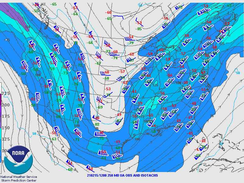
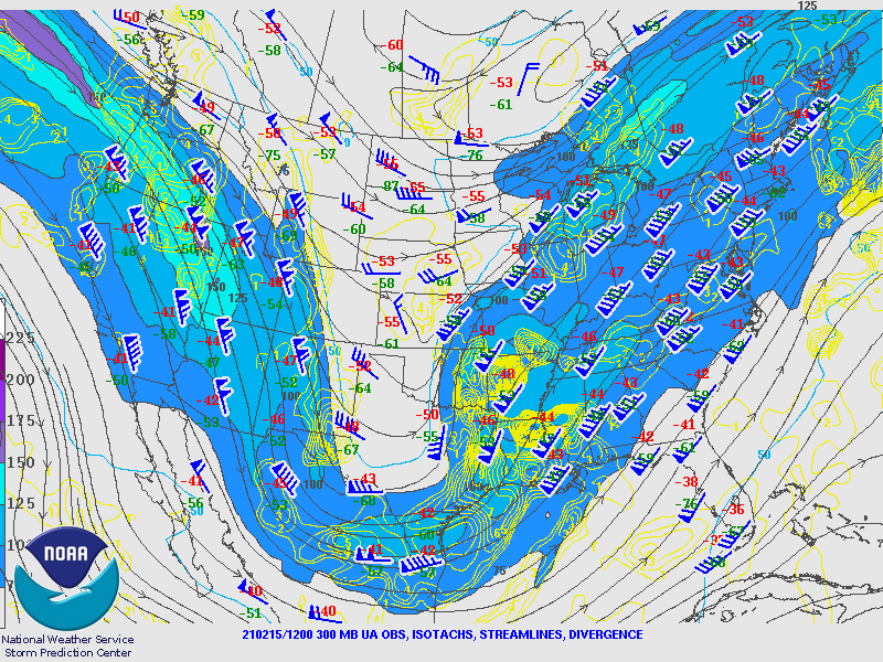
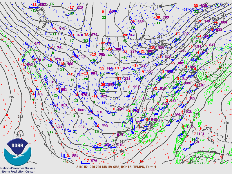
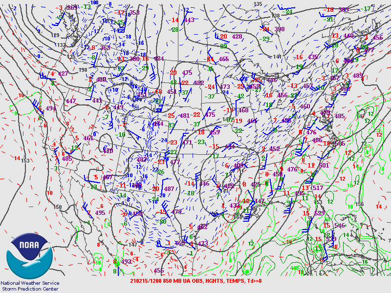
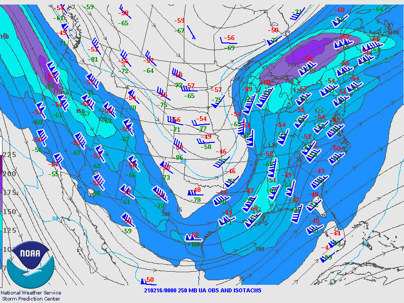
Upper Air Maps from SPC
February 15th 12Z Upper Air Maps
 |
 |
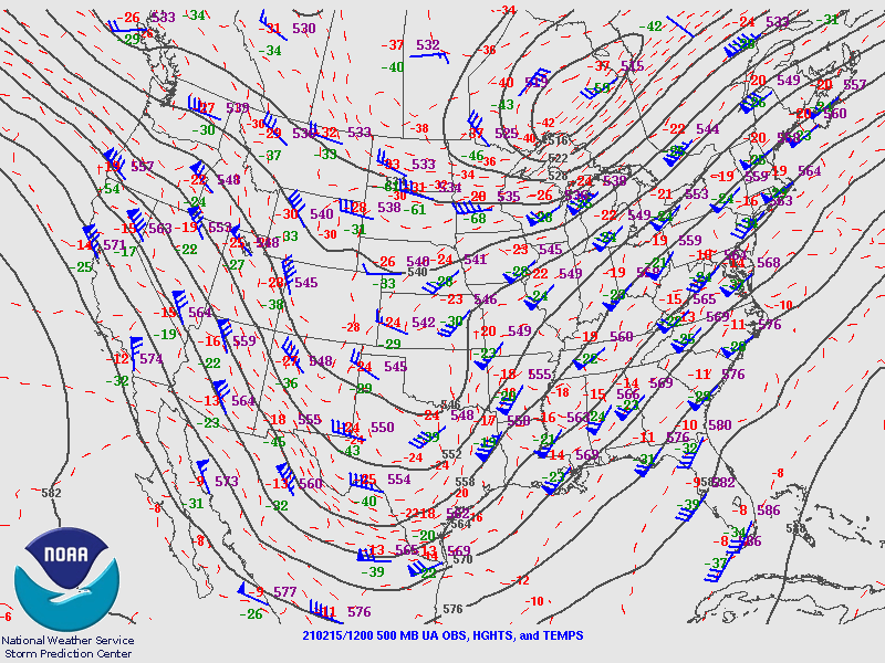 |
| Figure 1: 250MB | Figure 2: 300MB | Figure 3: 500MB |
 |
 |
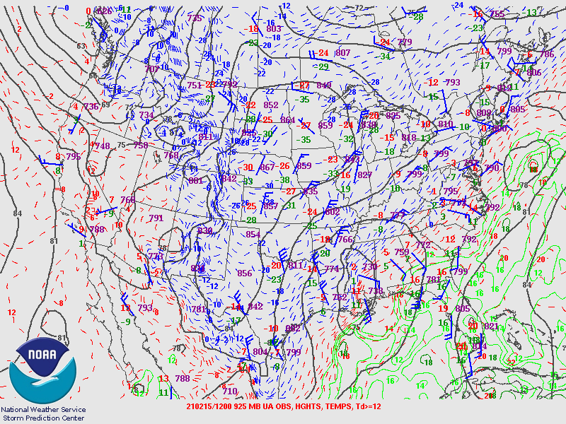 |
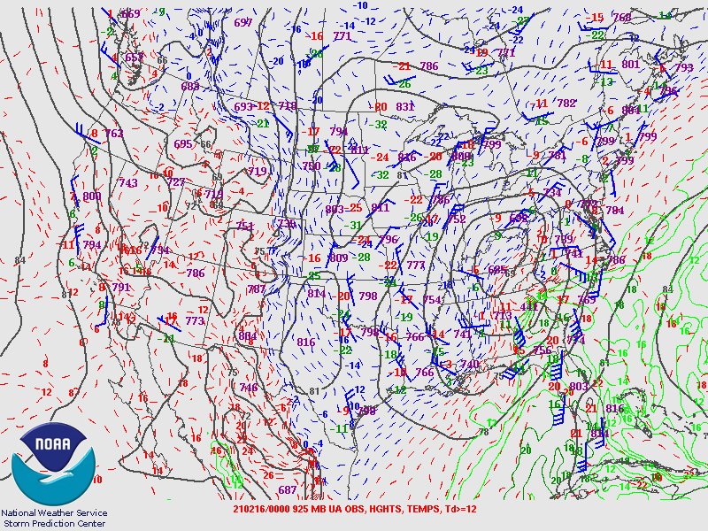
| Figure 4: 700MB | Figure 5: 850MB | Figure 6: 925MB |
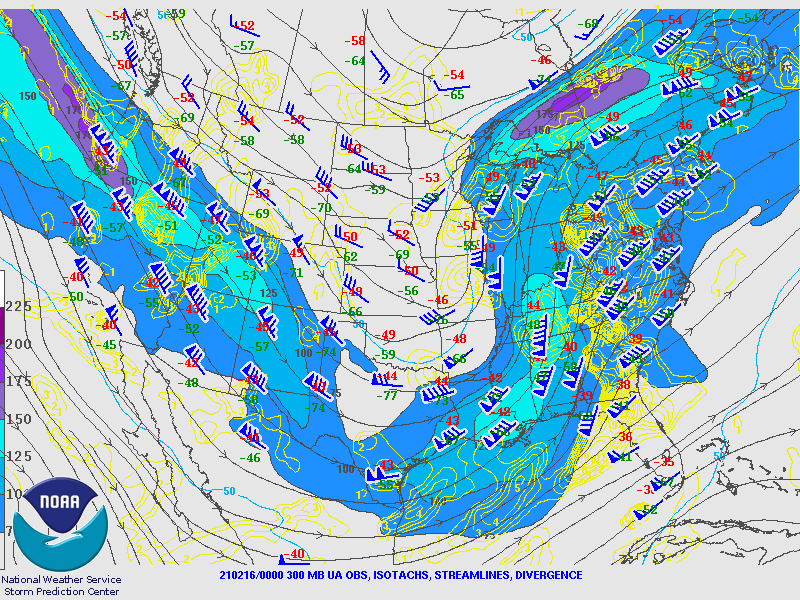
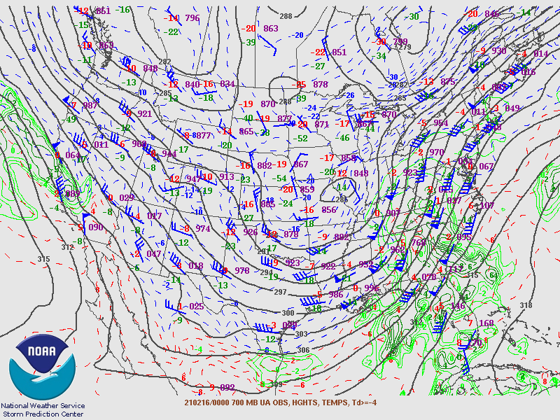
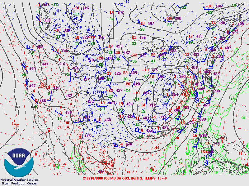
February 16th 00Z Upper Air Maps
 |
 |
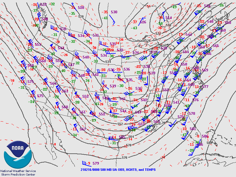 |
| Figure 7: 250MB | Figure 8: 300MB | Figure 9: 500MB |
 |
 |
 |
| Figure 10: 700MB | Figure 11: 850MB | Figure 12: 925MB |
Surface Maps from WPC.
 |
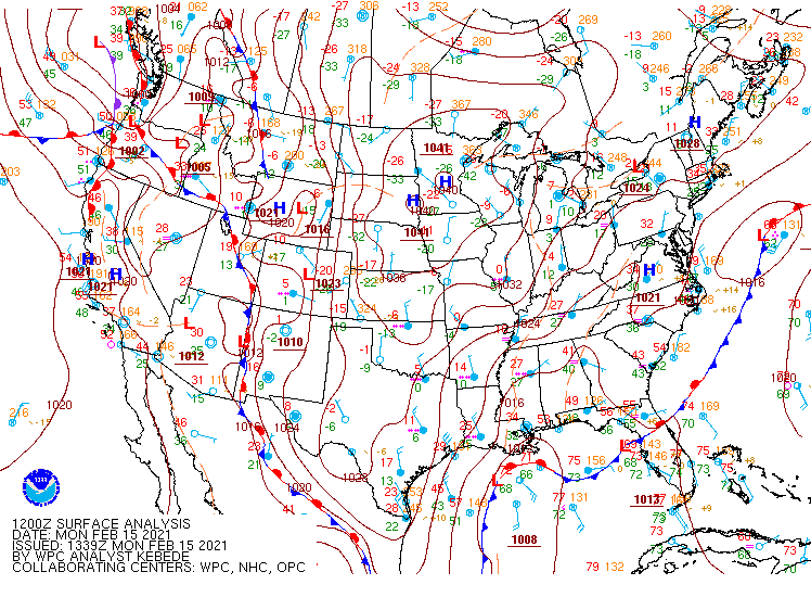 |
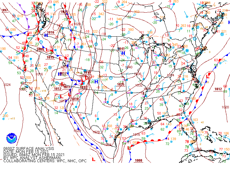
| Figure 1: February 15th 06Z SFC | Figure 2: February 15th 12Z SFC |
 |
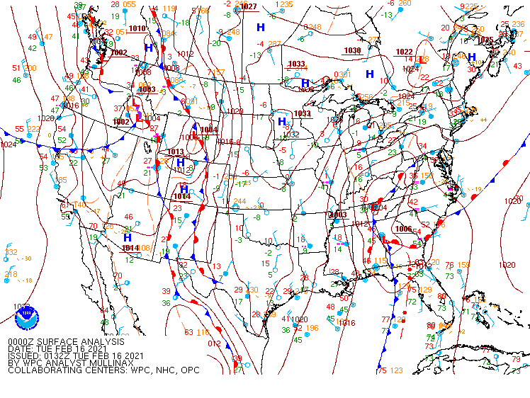 |
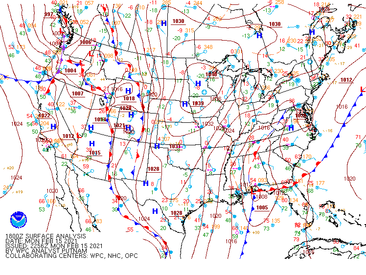
| Figure 3: February 15th 18Z SFC | Figure 4: February 16th 00Z SFC |
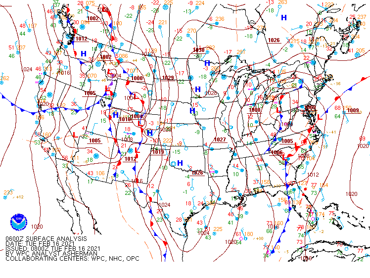 |
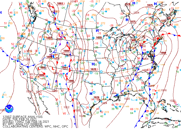 |
| Figure 5: February 16th 06Z SFC | Figure 6: February 16th 12Z SFC |
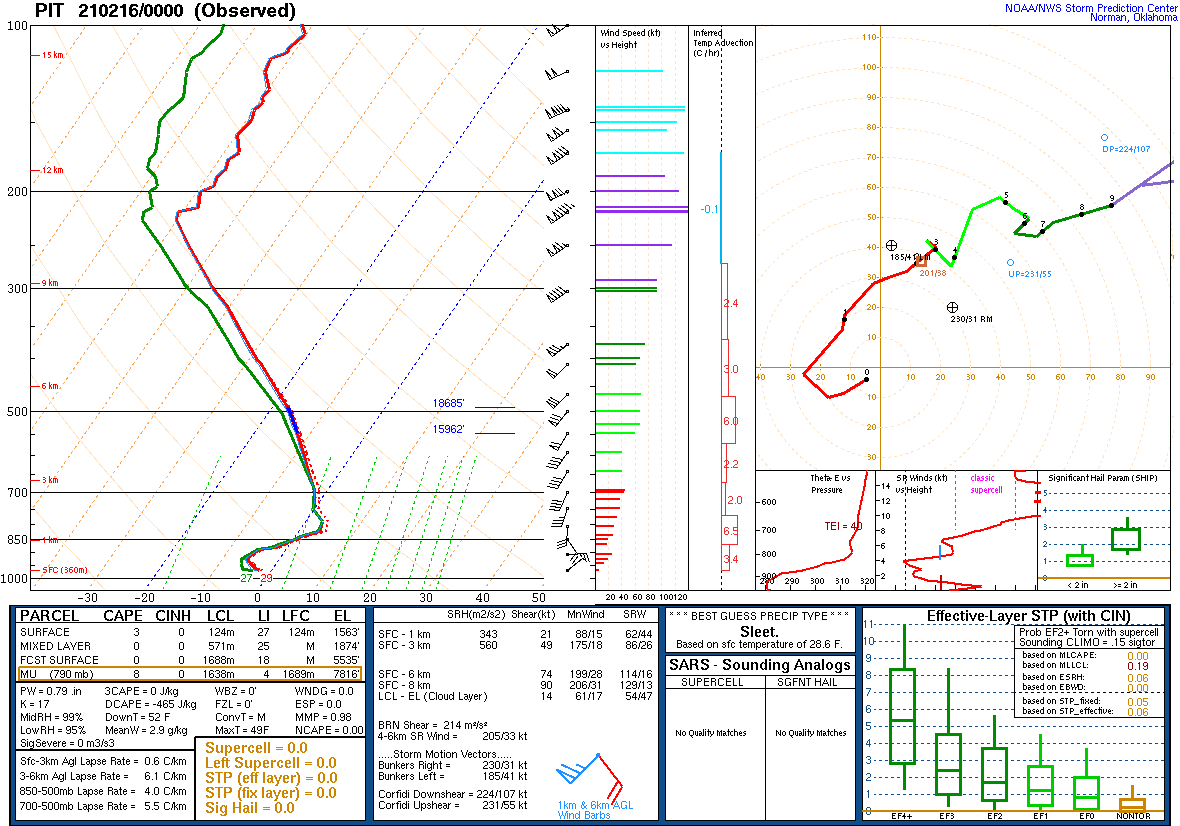
Additional environmental data.
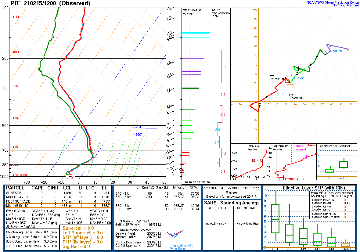
KPIT Skew-T Observation
 |
 |
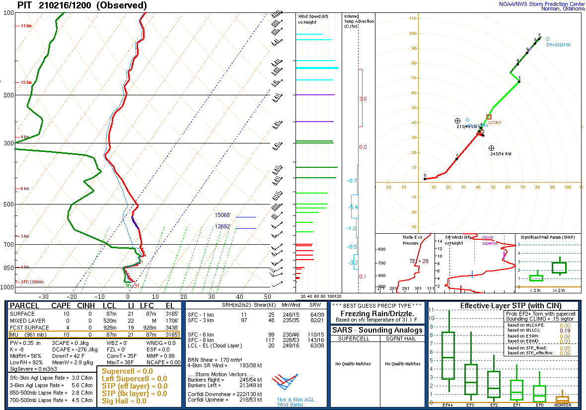 |
| Figure 7: February 15th 12Z | Figure 8: February 16th 00Z | Figure 9: February 16th 12Z |
 |
Media use of NWS Web News Stories is encouraged! Please acknowledge the NWS as the source of any news information accessed from this site. |
|

