Overview
|
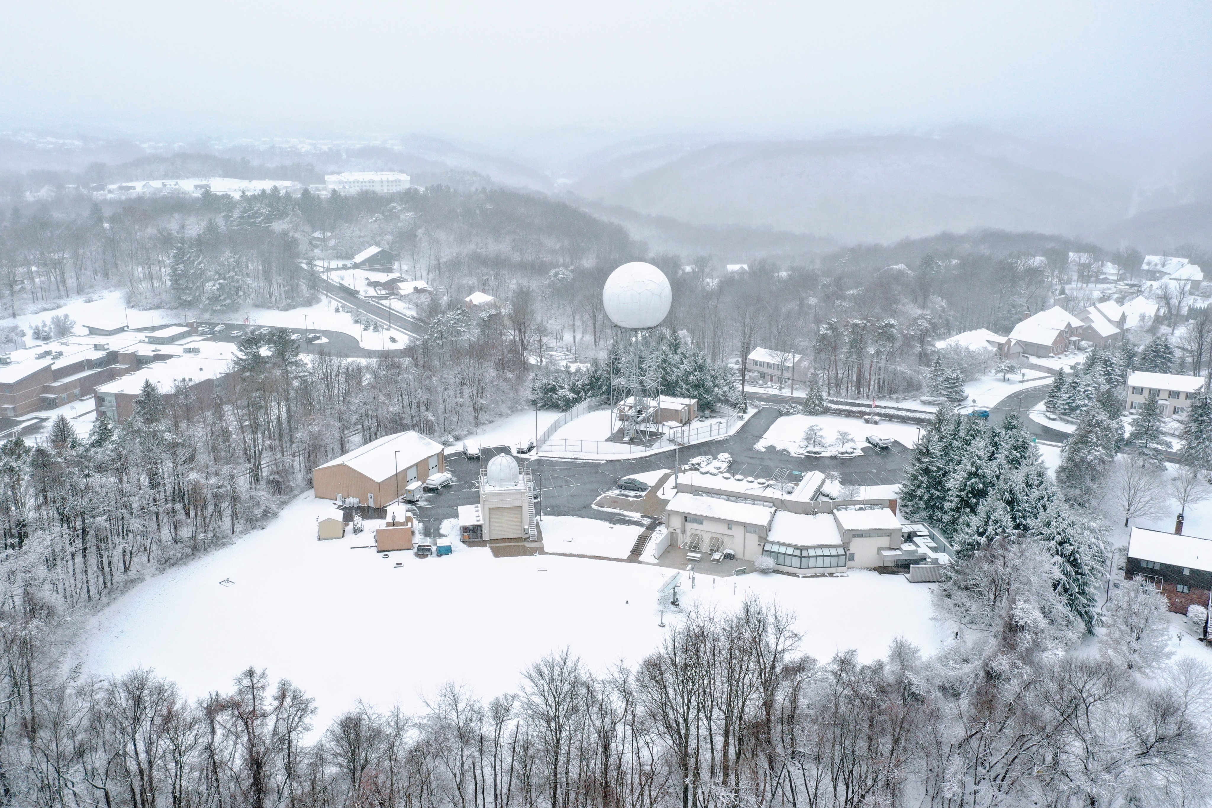
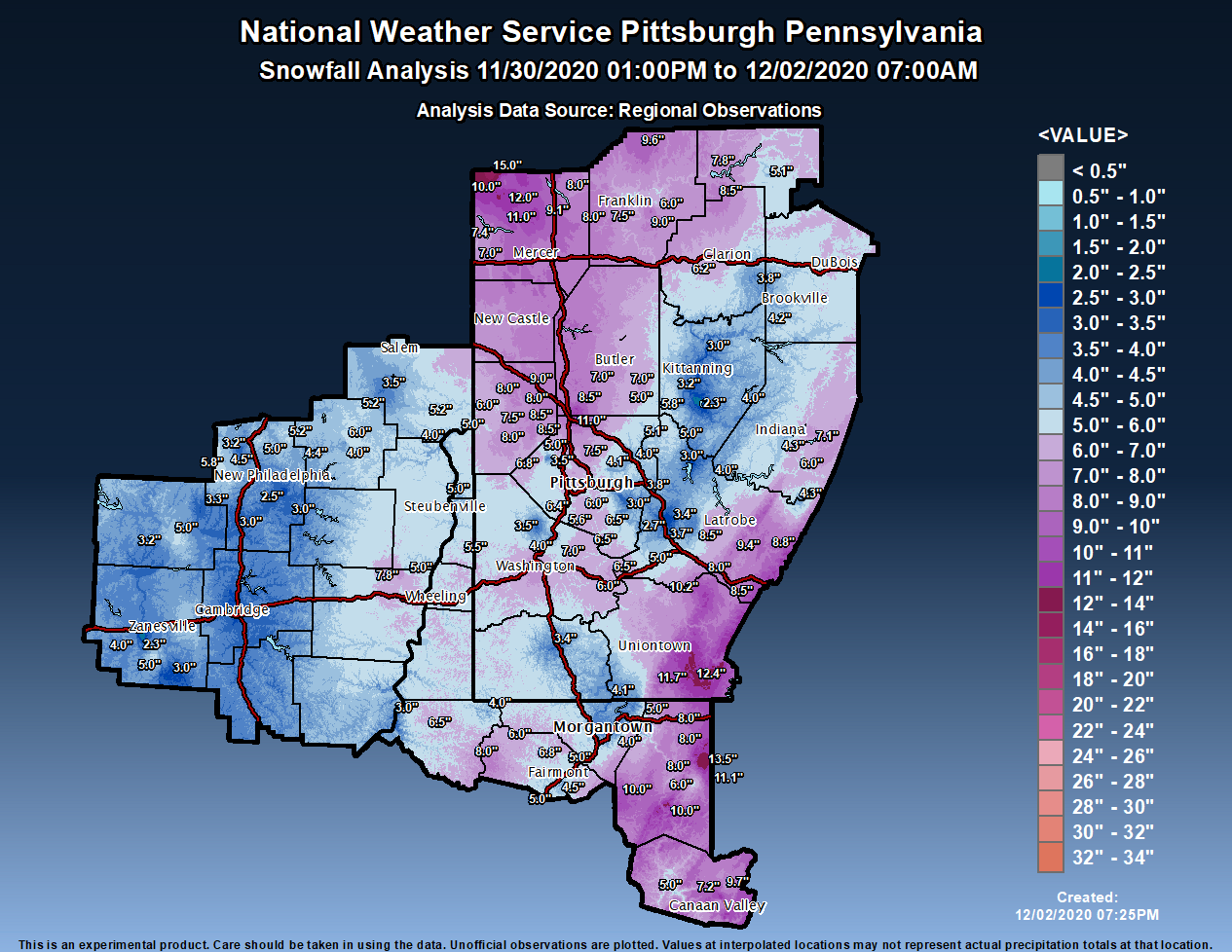
The Winter Storm on December 1st fittingly began on Meteorological Winter. The surface low began to develop over the Lower MS River Valley and into the southern Appalachian Range in the early morning hours of November 30th. The low then began to strengthen as it tracked up the east coast. A secondary low tacked northeast along the western side of the Appalachians bringing moderate to heavy snow at times to the OH Valley. Even after, these twin lows tracked into upstate NY, wrap around moisture and enhanced lake effect kept accumulating snow falling over the forecast area overnight from the evening of the 30th through the entire day of the 1st of December. The National Weather Service Office in Moon Township recorded a storm total of 6.8 inches of snow from this event and was the most snow recorded on this date since 1974! The most snow recorded was in Jamestown in Mercer County with a measurement of 15 inches! |
(Credit Jared Rackley) |
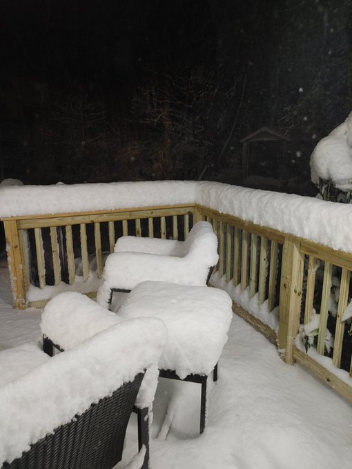
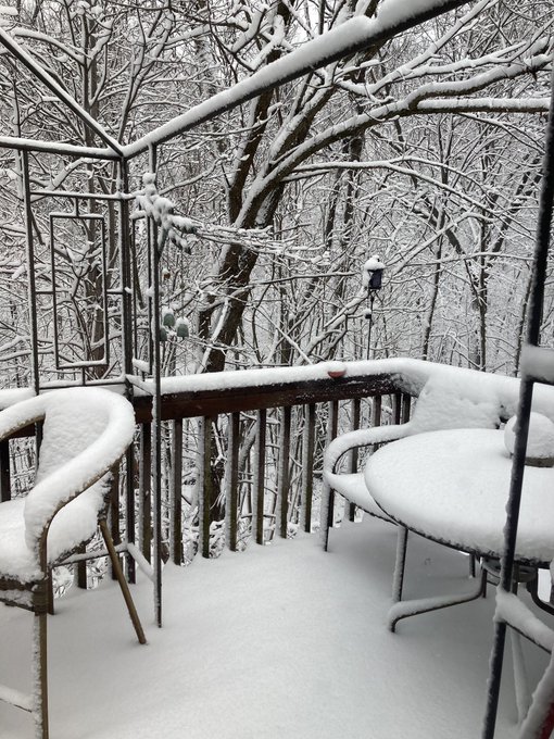
Snow/Ice
Photos & Video
Header
 |
 |
 |
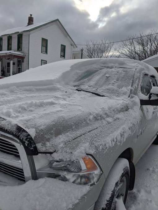
| Economy, PA (Credit: Richard Jernigan) |
Cranberry, PA (Credit: Merry Chrysler) |
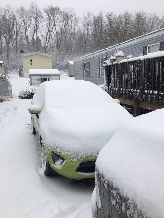
Monaca, PA (Credit: Danielle Rhinelander) |
 |
 |
 |
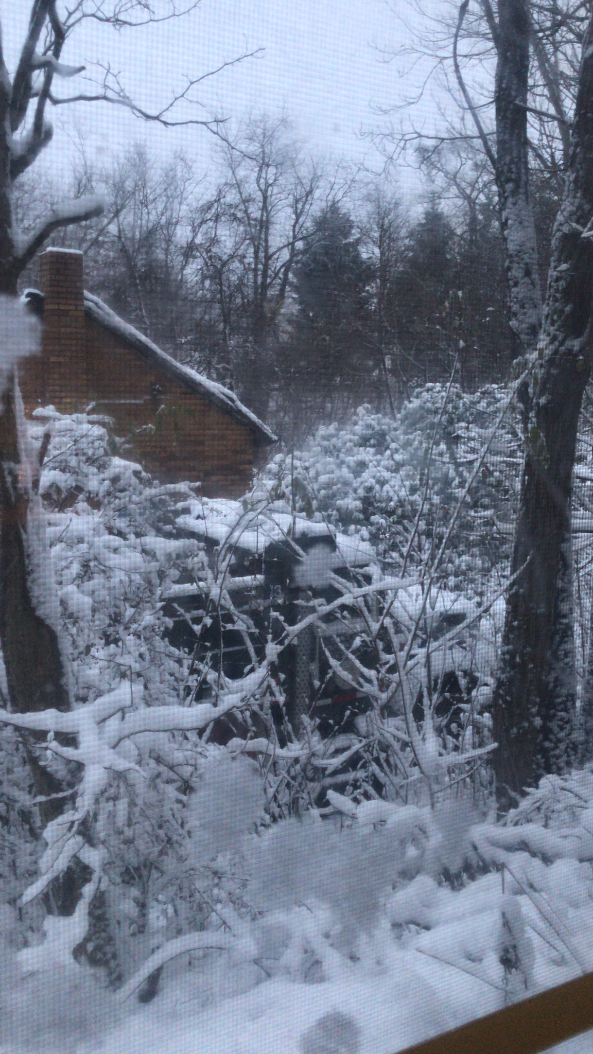
| Venango County, PA (Credit: Christian) |
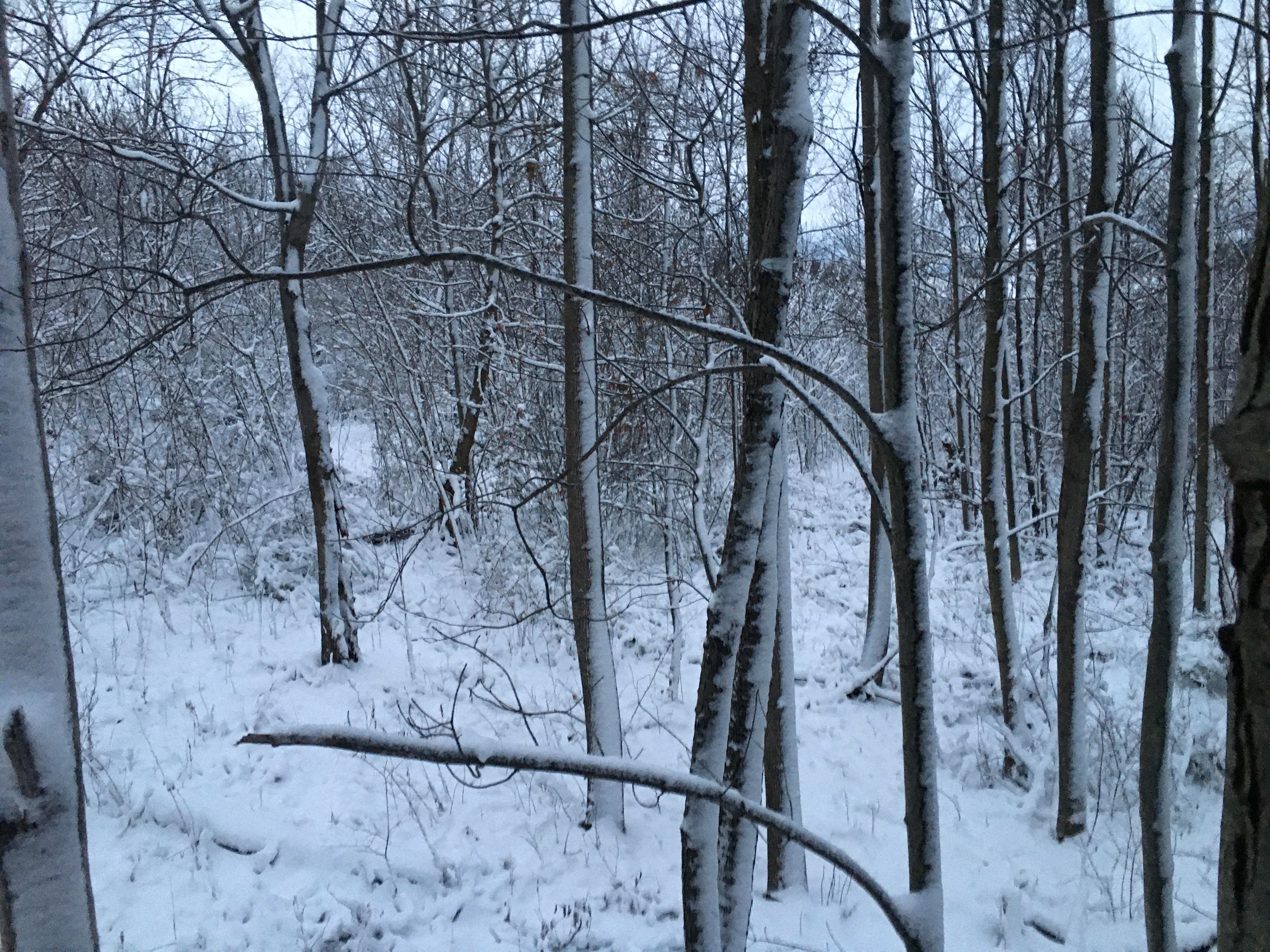
Chaintown, PA (Credit: David) |
Imperial, PA (Credit: David) |
Storm Reports
Public Information Statement
Spotter Reports
National Weather Service Pittsburgh PA
700 PM EST Wed Dec 02 2020

The following are unofficial observations taken during the past 22
hours for the storm that has been affecting our region. Appreciation
is extended to highway departments, cooperative observers, Skywarn
spotters and media for these reports. This summary also is available
on our home page at weather.gov/pittsburgh

************STORM TOTAL SNOWFALL (11/30 to 12/02)************

LOCATION                TOTAL      TIME/DATE  COMMENTS
                     SNOWFALL       MEASURED
                     (inches)

OHIO

...Belmont County...
  3 SW Mount Pleasant     7.8   600 AM 12/02  CoCoRaHS

...Carroll County...
  1 NE Carrollton         6.0  1200 AM 12/02  Dept of Highways
  Augusta                 5.2   548 PM 12/01  Public
  Carrollton              4.0   844 AM 12/01  Facebook

...Columbiana County...
  4 N Wellsville          5.2   900 AM 12/02  CoCoRaHS
  Calcutta                5.0   215 PM 12/01  Public
  Wellsville              4.0   822 PM 12/01  Trained Spotter
  ENE Hanoverton          3.5   400 AM 12/02  CoCoRaHS

...Coshocton County...
  Coshocton               5.0   216 PM 12/01  Trained Spotter
  2 NNE Fresno            3.3   800 AM 12/02  CoCoRaHS
  6 WSW Coshocton         3.2   720 AM 12/01  CoCoRaHS

...Guernsey County...
  Cambridge               3.0   514 PM 12/01  Public

...Jefferson County...
  2 WNW Steubenville      6.0   800 AM 12/02  CoCoRaHS
  1 NE Steubenville       5.0   700 AM 12/02  Co-Op Observer
  1 WSW Mount Pleasant    5.0   700 AM 12/02  CoCoRaHS

...Monroe County...
  1 W New Martinsville    3.0   600 AM 12/02  HADS

...Muskingum County...
  2 S Norwich             5.2  1155 AM 12/01  Public
  1 W Philo               5.0   928 AM 12/01  Trained Spotter
  Zanesville              4.0   918 AM 12/01  Facebook
  South Zanesville        4.0   751 AM 12/01  Facebook
  1 NNW Ruraldale         3.0   831 AM 12/01  Facebook
  1 ENE Putnam            2.3  1033 AM 12/01  Broadcast Media

...Tuscarawas County...
  Sugarcreek              5.8   807 AM 12/02  Facebook
  1 SE Mineral City       5.2   414 PM 12/01  Public
  3 N Dover               5.0   807 PM 12/01  Public
  WNW Carmichaels         4.5   700 AM 12/02  CoCoRaHS
  7 SE Mineral City       4.4   800 AM 12/02  CoCoRaHS
  1 NW Dennison           3.7   700 AM 12/02  Co-Op Observer
  5 WNW Dover             3.2   700 AM 12/02  CoCoRaHS
  Dennison                3.0   854 AM 12/01  Public
  2 S Stone Creek         3.0   600 AM 12/01  Public
  1 N Uhrichsville        2.5   700 AM 12/02  CoCoRaHS

PENNSYLVANIA

...Allegheny County...
  Berkeley Hills          7.5  1039 PM 12/01  Broadcast Media
  McKees Rocks            7.0  1201 AM 12/02  Facebook
  1 N Carnot-Moon         6.8   936 PM 12/01  Total since midnight
  2 NE Moon               6.8   730 AM 12/02  Co-Op Observer
  2 NW Jefferson           6.5  1000 PM 12/01  CoCoRaHS
  1 SW Bridgeville        6.4   700 AM 12/02  CoCoRaHS
  4 NNW Pittsburgh        6.0   600 AM 12/02  CoCoRaHS
  Lawrenceville           6.0  1159 PM 12/01  NWS Employee
  Beechview               6.0  1000 PM 12/01  Twitter
  2 SE South Fayette      5.6   700 AM 12/02  CoCoRaHS
  1 S Carnot-Moon         5.5   700 AM 12/02  CoCoRaHS
  1 W Edgeworth           5.0   543 AM 12/02  Co-Op Observer
  NW Aspinwall            4.1   700 AM 12/02  CoCoRaHS
  1 S Acmetonia           4.0   600 AM 12/02  Co-Op Observer
  2 SW Murrysville        3.8   700 AM 12/02  Co-Op Observer
  2 WNW Coraopolis        3.5   700 AM 12/02  CoCoRaHS
  Braddock Lock And Da    3.0   600 AM 12/02  Co-Op Observer

...Armstrong County...
  Freeport                5.8   622 PM 12/01  Trained Spotter
  3 NNW Shelocta          4.0   700 AM 12/02  CoCoRaHS
  1 SSW Kittanning        3.2   700 AM 12/02  CoCoRaHS
  3 SSW Templeton         3.0   800 AM 12/02  CoCoRaHS
  4 S Lenape Heights      2.3   700 AM 12/02  Co-Op Observer

...Beaver County...
  3 NE New Brighton       9.0   800 AM 12/02  CoCoRaHS
  Aliquippa               8.5   850 PM 12/01  Public
  1 SW Monaca             8.5  1015 PM 12/01  Twitter
  New Brighton            8.0  1200 AM 12/02  Facebook
  Beaver Falls            8.0   808 AM 12/02  Facebook
  3 NNW New Sheffield       8.0   810 AM 12/02  8 Inches Storm Total
  2 SW Monaca             7.5   905 PM 12/01  Trained Spotter
  6 W Beaver              6.0   700 AM 12/02  CoCoRaHS

...Butler County...
  Mars                   11.5   752 PM 12/01  Twitter
  Seven Fields           11.0   714 PM 12/01  Public
  2 NNE Fox Run           8.5   600 AM 12/02  CoCoRaHS
  N Cabot                 7.0   700 AM 12/02  CoCoRaHS
  2 S Butler              7.0   810 AM 12/02  Facebook
  2 NE Sarver             5.0   629 AM 12/02  CoCoRaHS
  2 WNW Cabot             3.4   700 AM 12/02  CoCoRaHS

...Clarion County...
  3 SW Clarion            6.2   700 AM 12/02  Co-Op Observer
  4 WNW Summerville       3.8   800 AM 12/02  CoCoRaHS

...Fayette County...
  1 ENE Farmington       12.4   700 AM 12/02  CoCoRaHS
  Farmington             11.7   737 AM 12/02  Public
  Woddale                10.2   849 PM 12/01  Trained Spotter
  1 NE Hopwood            7.0   700 AM 12/02  CoCoRaHS
  1 SE Point Marion       4.1   700 AM 12/02  CoCoRaHS

...Forest County...
  7 SSE Tionesta          8.5   700 AM 12/02  CoCoRaHS
  Tionesta                7.8   832 AM 12/02  7.75 Inches Storm Total
  5 W Marienville         5.1   500 AM 12/02  CoCoRaHS

...Greene County...
  1 E Waynesburg          3.4   700 AM 12/02  Co-Op Observer

...Indiana County...
  Pikes Peak              7.1   618 PM 12/01  Public
  Brush Valley            6.0   932 PM 12/01  Trained Spotter
  3 SE Indiana            4.3   700 AM 12/02  Co-Op Observer

...Jefferson County...
  S Timblin               4.2   715 AM 12/02  CoCoRaHS

...Lawrence County...
  Ellwood City            4.5   905 PM 12/01  Trained Spotter

...Mercer County...
  Jamestown              15.0   230 AM 12/02  Facebook
  Greenville             12.0  1100 PM 12/01  Facebook
  1 NE Fredonia          11.0   554 PM 12/01  Public
  3 N Greenville         10.0   434 PM 12/01  Facebook
  2 W Stoneboro           9.1   320 PM 12/01  Trained Spotter
  1 SE Mercer             8.2   846 PM 12/01  Public
  New Lebanon             8.0   739 PM 12/01  Facebook
  Sharpsville             7.4   618 PM 12/01  Public
  1 N Sharon              7.0   732 PM 12/01  Public

...Venango County...
  6 SW Titusville         9.6   700 AM 12/02  CoCoRaHS
  Cranberry               9.0   615 PM 12/01  Trained Spotter
  Polk                    8.0   700 PM 12/01  Facebook
  1 SSW Franklin          7.5   600 AM 12/02  CoCoRaHS
  1 NNE Seneca            6.0   700 AM 12/02  CoCoRaHS
  1 E Franklin            4.8   930 AM 12/02  Co-Op Observer

...Washington County...
  Washington              8.0   852 PM 12/01  Trained Spotter
  1 WNW Venetia           7.0   800 AM 12/02  CoCoRaHS
  Charleroi               6.5  1000 PM 12/01  Twitter
  1 NNW Finleyville       6.5   700 AM 12/02  CoCoRaHS
  SSE Dunlevy             6.0   800 AM 12/02  CoCoRaHS
  McMurray                5.3   700 AM 12/02  CoCoRaHS
  1 ENE Canonsburg        4.0   700 AM 12/02  CoCoRaHS
  4 NW Canonsburg         3.5   700 AM 12/02  CoCoRaHS

...Westmoreland County...
  SE Ligonier             9.4   700 AM 12/02  CoCoRaHS
  1 E Ligonier            8.8   700 AM 12/02  CoCoRaHS
  1 SSE Donohoe           8.5   822 AM 12/02  8.5 inches Storm Total
  Donegal                 8.5  1045 PM 12/01  Picture provided.
  2 NW Donegal            8.0   700 AM 12/02  Co-Op Observer
  1 WNW Lower Burrell     5.1   800 AM 12/02  CoCoRaHS
  1 SW Leechburg          5.0   800 AM 12/02  CoCoRaHS
  1 SW New Stanton        5.0   718 AM 12/02  Co-Op Observer
  ESE New Florence        4.3   900 AM 12/02  CoCoRaHS
  2 S Saltsburg           4.0   700 AM 12/02  Co-Op Observer
  SW Greensburg           3.7   800 AM 12/02  CoCoRaHS
  1 WNW Greensburg        3.4   726 AM 12/02  CoCoRaHS
  3 E North Washington    3.0   700 AM 12/02  Co-Op Observer
  NNE Adamsburg           2.7  1000 AM 12/02  CoCoRaHS

WEST VIRGINIA

...Brooke County...
  Bethany                 5.5   635 PM 12/01  Facebook

...Hancock County...
  Weirton                 5.0   530 PM 12/01  Twitter

...Marion County...
  Curtisville             8.0   910 PM 12/01  Broadcast Media
  2 N Rivesville          6.8   600 AM 12/02  CoCoRaHS
  Metz                    6.0   908 PM 12/01  Broadcast Media
  Fairmont                6.0   909 PM 12/01  Broadcast Media
  White Hall              5.0   906 PM 12/01  Broadcast Media
  Rivesville              5.0   907 PM 12/01  Broadcast Media
  1 SSE Fairmont          4.5  1200 AM 12/02  Co-Op Observer

...Monongalia County...
  6 SW Morgantown         5.9   700 AM 12/02  CoCoRaHS
  Coopers Rock            5.0   900 AM 12/01  Facebook
  1 S Pierpont            4.0   833 AM 12/01  Public
  Brookhaven              4.0   229 PM 12/01  Public
  Morgantown              3.9   749 PM 12/01  Broadcast Media

...Preston County...
  5 NNE Terra Alta       13.5   700 AM 12/02  CoCoRaHS
  3 ENE Terra Alta       11.1   700 AM 12/02  CoCoRaHS
  Independence           10.0   736 PM 12/01  Public
  Rowlesburg             10.0   930 PM 12/01  Broadcast Media
  1 E Kingwood            8.0   700 AM 12/02  CoCoRaHS
  Bruceton Mills          8.0   906 PM 12/01  Broadcast Media
  Valley Point            8.0   908 PM 12/01  Broadcast Media
  Terra Alta              6.0   909 PM 12/01  Broadcast Media

...Tucker County...
  3 S Canaan Hgts        11.8   900 AM 12/02  Co-Op Observer
  Davis                   9.7   700 AM 12/02  Co-Op Observer
  Canaan Valley-Nature    7.6   745 PM 12/01  Broadcast Media
  3 SE Davis              7.2   700 PM 12/01  Co-Op Observer
  3 SE Parsons            5.0   700 AM 12/02  Co-Op Observer


...Wetzel County...
  7 E New Martinsville    6.5   800 AM 12/02  CoCoRaHS
  Hundred                 4.0   747 PM 12/01  Broadcast Media

&&

*****METADATA*****
:12/02/2020,  600 AM, OH, Belmont, Mount Pleasant, 3, SW, 40.1468, -80.8399, SNOW, 7.8, Inch, CoCoRaHS, Storm Total Snow,
:12/02/2020, 1200 AM, OH, Carroll, Carrollton, 1, NE, 40.5881, -81.0810, SNOW, 6.0, Inch, Dept of Highways, Storm Total Snow,
:12/01/2020,  548 PM, OH, Carroll, Augusta, , , 40.6859, -81.0209, SNOW, 5.2, Inch, Public, Storm Total Snow,
:12/01/2020,  844 AM, OH, Carroll, Carrollton, , , 40.5798, -81.0913, SNOW, 4.0, Inch, Facebook, Storm Total Snow,
:12/02/2020,  900 AM, OH, Columbiana, Wellsville, 4, N, 40.6644, -80.6424, SNOW, 5.2, Inch, CoCoRaHS, Storm Total Snow,
:12/01/2020,  215 PM, OH, Columbiana, Calcutta, , , 40.6760, -80.5783, SNOW, 5.0, Inch, Public, Storm Total Snow,
:12/01/2020,  822 PM, OH, Columbiana, Wellsville, , , 40.6027, -80.6563, SNOW, 4.0, Inch, Trained Spotter, Storm Total Snow,
:12/02/2020,  400 AM, OH, Columbiana, Hanoverton, , ENE, 40.7570, -80.9292, SNOW, 3.5, Inch, CoCoRaHS, Storm Total Snow,
:12/01/2020,  216 PM, OH, Coshocton, Coshocton, , , 40.2637, -81.8496, SNOW, 5.0, Inch, Trained Spotter, Storm Total Snow,
:12/02/2020,  800 AM, OH, Coshocton, Fresno, 2, NNE, 40.3583, -81.7193, SNOW, 3.3, Inch, CoCoRaHS, Storm Total Snow,
:12/01/2020,  720 AM, OH, Coshocton, Coshocton, 6, WSW, 40.2201, -81.9365, SNOW, 3.2, Inch, CoCoRaHS, Storm Total Snow,
:12/01/2020,  514 PM, OH, Guernsey, Cambridge, , , 40.0250, -81.5869, SNOW, 3.0, Inch, Public, Storm Total Snow,
:12/02/2020,  800 AM, OH, Jefferson, Steubenville, 2, WNW, 40.3760, -80.6820, SNOW, 6.0, Inch, CoCoRaHS, Storm Total Snow,
:12/02/2020,  700 AM, OH, Jefferson, Steubenville, 1, NE, 40.3764, -80.6281, SNOW, 5.0, Inch, Co-Op Observer, Storm Total Snow,
:12/02/2020,  700 AM, OH, Jefferson, Mount Pleasant, 1, WSW, 40.1650, -80.8229, SNOW, 5.0, Inch, CoCoRaHS, Storm Total Snow,
:12/02/2020,  600 AM, OH, Monroe, New Martinsville, 1, W, 39.6669, -80.8700, SNOW, 3.0, Inch, HADS, Storm Total Snow,
:12/01/2020, 1155 AM, OH, Muskingum, Norwich, 2, S, 39.9608, -81.8052, SNOW, 5.2, Inch, Public, Storm Total Snow,
:12/01/2020,  928 AM, OH, Muskingum, Philo, 1, W, 39.8612, -81.9282, SNOW, 5.0, Inch, Trained Spotter, Storm Total Snow,
:12/01/2020,  918 AM, OH, Muskingum, Zanesville, , , 39.9524, -82.0120, SNOW, 4.0, Inch, Facebook, Storm Total Snow,
:12/01/2020,  751 AM, OH, Muskingum, South Zanesville, , , 39.9090, -82.0170, SNOW, 4.0, Inch, Facebook, Storm Total Snow,
:12/01/2020,  831 AM, OH, Muskingum, Ruraldale, 1, NNW, 39.7954, -81.8510, SNOW, 3.0, Inch, Facebook, Storm Total Snow,
:12/01/2020, 1033 AM, OH, Muskingum, Putnam, 1, ENE, 39.9290, -81.9840, SNOW, 2.3, Inch, Broadcast Media, Storm Total Snow,
:12/02/2020,  807 AM, OH, Tuscarawas, Sugarcreek, , , 40.5066, -81.6419, SNOW, 5.8, Inch, Facebook, Storm Total Snow,
:12/01/2020,  414 PM, OH, Tuscarawas, Mineral City, 1, SE, 40.5922, -81.3480, SNOW, 5.2, Inch, Public, Storm Total Snow,
:12/01/2020,  807 PM, OH, Tuscarawas, Dover, 3, N, 40.5732, -81.4798, SNOW, 5.0, Inch, Public, Storm Total Snow,
:12/02/2020,  700 AM, OH, Tuscarawas, Carmichaels, , WNW, 40.5114, -81.6257, SNOW, 4.5, Inch, CoCoRaHS, Storm Total Snow,
:12/02/2020,  800 AM, OH, Tuscarawas, Mineral City, 7, SE, 40.5205, -81.2769, SNOW, 4.4, Inch, CoCoRaHS, Storm Total Snow,
:12/02/2020,  700 AM, OH, Tuscarawas, Dennison, 1, NW, 40.4056, -81.3431, SNOW, 3.7, Inch, Co-Op Observer, Storm Total Snow,
:12/02/2020,  700 AM, OH, Tuscarawas, Dover, 5, WNW, 40.5507, -81.5640, SNOW, 3.2, Inch, CoCoRaHS, Storm Total Snow,
:12/01/2020,  854 AM, OH, Tuscarawas, Dennison, , , 40.3887, -81.3315, SNOW, 3.0, Inch, Public, Storm Total Snow,
:12/01/2020,  600 AM, OH, Tuscarawas, Stone Creek, 2, S, 40.3463, -81.5674, SNOW, 3.0, Inch, Public, Storm Total Snow,
:12/02/2020,  700 AM, OH, Tuscarawas, Uhrichsville, 1, N, 40.4099, -81.3532, SNOW, 2.5, Inch, CoCoRaHS, Storm Total Snow,
:12/01/2020, 1039 PM, PA, Allegheny, Berkeley Hills, , , 40.5290, -80.0050, SNOW, 7.5, Inch, Broadcast Media, Storm Total Snow,
:12/02/2020, 1201 AM, PA, Allegheny, McKees Rocks, , , 40.4693, -80.0621, SNOW, 7.0, Inch, Facebook, Storm Total Snow,
:12/01/2020,  936 PM, PA, Allegheny, Carnot-Moon, 1, N, 40.5319, -80.2174, SNOW, 6.8, Inch, Official NWS Obs, Storm Total Snow, Total since midnight
:12/02/2020,  730 AM, PA, Allegheny, Moon, 2, NE, 40.5319, -80.2172, SNOW, 6.8, Inch, Co-Op Observer, Storm Total Snow,
:12/01/2020, 1000 PM, PA, Allegheny, Jefferson, 2, NW, 40.3131, -79.9523, SNOW, 6.5, Inch, CoCoRaHS, Storm Total Snow,
:12/02/2020,  700 AM, PA, Allegheny, Bridgeville, 1, SW, 40.3417, -80.1229, SNOW, 6.4, Inch, CoCoRaHS, Storm Total Snow,
:12/02/2020,  600 AM, PA, Allegheny, Pittsburgh, 4, NNW, 40.4888, -80.0006, SNOW, 6.0, Inch, CoCoRaHS, Storm Total Snow,
:12/01/2020, 1159 PM, PA, Allegheny, Lawrenceville, , , 40.4624, -79.9659, SNOW, 6.0, Inch, NWS Employee, Storm Total Snow,
:12/01/2020, 1000 PM, PA, Allegheny, Beechview, , , 40.4106, -80.0248, SNOW, 6.0, Inch, Twitter, Storm Total Snow,
:12/02/2020,  700 AM, PA, Allegheny, South Fayette, 2, SE, 40.3381, -80.1159, SNOW, 5.6, Inch, CoCoRaHS, Storm Total Snow,
:12/02/2020,  700 AM, PA, Allegheny, Carnot-Moon, 1, S, 40.5061, -80.2119, SNOW, 5.5, Inch, CoCoRaHS, Storm Total Snow,
:12/02/2020,  543 AM, PA, Allegheny, Edgeworth, 1, W, 40.5494, -80.2061, SNOW, 5.0, Inch, Co-Op Observer, Storm Total Snow,
:12/02/2020,  700 AM, PA, Allegheny, Aspinwall, , NW, 40.4928, -79.9043, SNOW, 4.1, Inch, CoCoRaHS, Storm Total Snow,
:12/02/2020,  600 AM, PA, Allegheny, Acmetonia, 1, S, 40.5361, -79.8153, SNOW, 4.0, Inch, Co-Op Observer, Storm Total Snow,
:12/02/2020,  700 AM, PA, Allegheny, Murrysville, 2, SW, 40.4122, -79.7261, SNOW, 3.8, Inch, Co-Op Observer, Storm Total Snow,
:12/02/2020,  700 AM, PA, Allegheny, Coraopolis, 2, WNW, 40.5256, -80.1967, SNOW, 3.5, Inch, CoCoRaHS, Storm Total Snow,
:12/02/2020,  600 AM, PA, Allegheny, Braddock Lock And Dam, , , 40.3917, -79.8594, SNOW, 3.0, Inch, Co-Op Observer, Storm Total Snow,
:12/01/2020,  622 PM, PA, Armstrong, Freeport, , , 40.6826, -79.6828, SNOW, 5.8, Inch, Trained Spotter, Storm Total Snow,
:12/02/2020,  700 AM, PA, Armstrong, Shelocta, 3, NNW, 40.6981, -79.3228, SNOW, 4.0, Inch, CoCoRaHS, Storm Total Snow,
:12/02/2020,  700 AM, PA, Armstrong, Kittanning, 1, SSW, 40.8095, -79.5306, SNOW, 3.2, Inch, CoCoRaHS, Storm Total Snow,
:12/02/2020,  800 AM, PA, Armstrong, Templeton, 3, SSW, 40.8779, -79.4790, SNOW, 3.0, Inch, CoCoRaHS, Storm Total Snow,
:12/02/2020,  700 AM, PA, Armstrong, Lenape Heights, 4, S, 40.7136, -79.5150, SNOW, 2.3, Inch, Co-Op Observer, Storm Total Snow,
:12/02/2020,  800 AM, PA, Beaver, New Brighton, 3, NE, 40.7694, -80.2729, SNOW, 9.0, Inch, CoCoRaHS, Storm Total Snow,
:12/01/2020,  850 PM, PA, Beaver, Aliquippa, , , 40.6174, -80.2550, SNOW, 8.5, Inch, Public, Storm Total Snow,
:12/01/2020, 1015 PM, PA, Beaver, Monaca, 1, SW, 40.6660, -80.2890, SNOW, 8.5, Inch, Twitter, Storm Total Snow,
:12/02/2020, 1200 AM, PA, Beaver, New Brighton, , , 40.7356, -80.3089, SNOW, 8.0, Inch, Facebook, Storm Total Snow,
:12/02/2020,  808 AM, PA, Beaver, Beaver Falls, , , 40.7609, -80.3224, SNOW, 8.0, Inch, Facebook, Storm Total Snow,
:12/02/2020,  810 AM, PA, Beaver, New Sheffield, 3, NNW, 40.6324, -80.3006, SNOW, 8.0, Inch, NWS Employee, Storm Total Snow, 8 Inches Storm Total
:12/01/2020,  905 PM, PA, Beaver, Monaca, 2, SW, 40.6628, -80.3002, SNOW, 7.5, Inch, Trained Spotter, Storm Total Snow,
:12/02/2020,  700 AM, PA, Beaver, Beaver, 6, W, 40.7050, -80.4121, SNOW, 6.0, Inch, CoCoRaHS, Storm Total Snow,
:12/01/2020,  714 PM, PA, Butler, Seven Fields, , , 40.6884, -80.0620, SNOW, 11.0, Inch, Public, Storm Total Snow,
:12/02/2020,  600 AM, PA, Butler, Fox Run, 2, NNE, 40.7239, -80.0706, SNOW, 8.5, Inch, CoCoRaHS, Storm Total Snow,
:12/02/2020,  600 AM, PA, Butler, Fox Run, 2, NNE, 40.7239, -80.0706, SNOW, 8.5, Inch, CoCoRaHS, Storm Total Snow,
:12/02/2020,  700 AM, PA, Butler, Cabot, , N, 40.7687, -79.7669, SNOW, 7.0, Inch, CoCoRaHS, Storm Total Snow,
:12/02/2020,  810 AM, PA, Butler, Butler, 2, S, 40.8329, -79.8967, SNOW, 7.0, Inch, Facebook, Storm Total Snow,
:12/02/2020,  629 AM, PA, Butler, Sarver, 2, NE, 40.7488, -79.7054, SNOW, 5.0, Inch, CoCoRaHS, Storm Total Snow,
:12/02/2020,  700 AM, PA, Butler, Cabot, 2, WNW, 40.7725, -79.7956, SNOW, 3.4, Inch, CoCoRaHS, Storm Total Snow,
:12/02/2020,  700 AM, PA, Clarion, Clarion, 3, SW, 41.1922, -79.4356, SNOW, 6.2, Inch, Co-Op Observer, Storm Total Snow,
:12/02/2020,  800 AM, PA, Clarion, Summerville, 4, WNW, 41.1301, -79.2638, SNOW, 3.8, Inch, CoCoRaHS, Storm Total Snow,
:12/02/2020,  700 AM, PA, Fayette, Farmington, 1, ENE, 39.8100, -79.5576, SNOW, 12.4, Inch, CoCoRaHS, Storm Total Snow,
:12/02/2020,  737 AM, PA, Fayette, Farmington, , , 39.8073, -79.5656, SNOW, 11.7, Inch, Public, Storm Total Snow,
:12/01/2020,  849 PM, PA, Fayette, Woddale, , , 40.0912, -79.5248, SNOW, 10.2, Inch, Trained Spotter, Storm Total Snow,
:12/02/2020,  700 AM, PA, Fayette, Hopwood, 1, NE, 39.8885, -79.6835, SNOW, 7.0, Inch, CoCoRaHS, Storm Total Snow,
:12/02/2020,  700 AM, PA, Fayette, Point Marion, 1, SE, 39.7250, -79.8867, SNOW, 4.1, Inch, CoCoRaHS, Storm Total Snow,
:12/02/2020,  700 AM, PA, Forest, Tionesta, 7, SSE, 41.3940, -79.4131, SNOW, 8.5, Inch, CoCoRaHS, Storm Total Snow,
:12/02/2020,  832 AM, PA, Forest, Tionesta, , , 41.4960, -79.4468, SNOW, 7.8, Inch, Facebook, Storm Total Snow, 7.75 Inches Storm Total
:12/02/2020,  500 AM, PA, Forest, Marienville, 5, W, 41.4571, -79.1815, SNOW, 5.1, Inch, CoCoRaHS, Storm Total Snow,
:12/02/2020,  700 AM, PA, Greene, Waynesburg, 1, E, 39.8986, -80.1656, SNOW, 3.4, Inch, Co-Op Observer, Storm Total Snow,
:12/01/2020,  618 PM, PA, Indiana, Pikes Peak, , , 40.5984, -79.0109, SNOW, 7.1, Inch, Public, Storm Total Snow,
:12/01/2020,  932 PM, PA, Indiana, Brush Valley, , , 40.5362, -79.0664, SNOW, 6.0, Inch, Trained Spotter, Storm Total Snow,
:12/02/2020,  700 AM, PA, Indiana, Indiana, 3, SE, 40.5967, -79.1178, SNOW, 4.3, Inch, Co-Op Observer, Storm Total Snow,
:12/02/2020,  715 AM, PA, Jefferson, Timblin, , S, 40.9645, -79.1989, SNOW, 4.2, Inch, CoCoRaHS, Storm Total Snow,
:12/01/2020,  905 PM, PA, Lawrence, Ellwood City, , , 40.8609, -80.2835, SNOW, 4.5, Inch, Trained Spotter, Storm Total Snow,
:12/02/2020,  230 AM, PA, Mercer, Jamestown, , , 41.4849, -80.4370, SNOW, 15.0, Inch, Facebook, Storm Total Snow,
:12/01/2020, 1100 PM, PA, Mercer, Greenville, , , 41.4060, -80.3843, SNOW, 12.0, Inch, Facebook, Storm Total Snow,
:12/01/2020,  554 PM, PA, Mercer, Fredonia, 1, NE, 41.3324, -80.2452, SNOW, 11.0, Inch, Public, Storm Total Snow,
:12/01/2020,  434 PM, PA, Mercer, Greenville, 3, N, 41.4494, -80.3843, SNOW, 10.0, Inch, Facebook, Storm Total Snow,
:12/01/2020,  320 PM, PA, Mercer, Stoneboro, 2, W, 41.3335, -80.1420, SNOW, 9.1, Inch, Trained Spotter, Storm Total Snow,
:12/01/2020,  846 PM, PA, Mercer, Mercer, 1, SE, 41.2161, -80.2230, SNOW, 8.2, Inch, Public, Storm Total Snow,
:12/01/2020,  739 PM, PA, Mercer, New Lebanon, , , 41.4167, -80.0759, SNOW, 8.0, Inch, Facebook, Storm Total Snow,
:12/01/2020,  618 PM, PA, Mercer, Sharpsville, , , 41.2589, -80.4820, SNOW, 7.4, Inch, Public, Storm Total Snow,
:12/01/2020,  732 PM, PA, Mercer, Sharon, 1, N, 41.2487, -80.4998, SNOW, 7.0, Inch, Public, Storm Total Snow,
:12/02/2020,  700 AM, PA, Venango, Titusville, 6, SW, 41.5670, -79.7639, SNOW, 9.6, Inch, CoCoRaHS, Storm Total Snow,
:12/01/2020,  615 PM, PA, Venango, Cranberry, , , 41.3500, -79.7200, SNOW, 9.0, Inch, Trained Spotter, Storm Total Snow,
:12/01/2020,  700 PM, PA, Venango, Polk, , , 41.3692, -79.9301, SNOW, 8.0, Inch, Facebook, Storm Total Snow,
:12/02/2020,  600 AM, PA, Venango, Franklin, 1, SSW, 41.3728, -79.8501, SNOW, 7.5, Inch, CoCoRaHS, Storm Total Snow,
:12/02/2020,  700 AM, PA, Venango, Seneca, 1, NNE, 41.3846, -79.6979, SNOW, 6.0, Inch, CoCoRaHS, Storm Total Snow,
:12/02/2020,  930 AM, PA, Venango, Franklin, 1, E, 41.3903, -79.8217, SNOW, 4.8, Inch, Co-Op Observer, Storm Total Snow,
:12/01/2020,  852 PM, PA, Washington, Washington, , , 40.1743, -80.2474, SNOW, 8.0, Inch, Trained Spotter, Storm Total Snow,
:12/02/2020,  800 AM, PA, Washington, Venetia, 1, WNW, 40.2522, -80.0539, SNOW, 7.0, Inch, CoCoRaHS, Storm Total Snow,
:12/01/2020, 1000 PM, PA, Washington, Charleroi, , , 40.1392, -79.9005, SNOW, 6.5, Inch, Twitter, Storm Total Snow,
:12/02/2020,  700 AM, PA, Washington, Finleyville, 1, NNW, 40.2603, -80.0059, SNOW, 6.5, Inch, CoCoRaHS, Storm Total Snow,
:12/02/2020,  800 AM, PA, Washington, Dunlevy, , SSE, 40.1107, -79.8578, SNOW, 6.0, Inch, CoCoRaHS, Storm Total Snow,
:12/02/2020,  700 AM, PA, Washington, McMurray, , , 40.2831, -80.0857, SNOW, 5.3, Inch, CoCoRaHS, Storm Total Snow,
:12/02/2020,  700 AM, PA, Washington, Canonsburg, 1, ENE, 40.2670, -80.1747, SNOW, 4.0, Inch, CoCoRaHS, Storm Total Snow,
:12/02/2020,  700 AM, PA, Washington, Canonsburg, 4, NW, 40.3005, -80.2385, SNOW, 3.5, Inch, CoCoRaHS, Storm Total Snow,
:12/02/2020,  700 AM, PA, Westmoreland, Ligonier, , SE, 40.2432, -79.2353, SNOW, 9.4, Inch, CoCoRaHS, Storm Total Snow,
:12/02/2020,  700 AM, PA, Westmoreland, Ligonier, 1, E, 40.2468, -79.2154, SNOW, 8.8, Inch, CoCoRaHS, Storm Total Snow,
:12/02/2020,  822 AM, PA, Westmoreland, Donohoe, 1, SSE, 40.3009, -79.4672, SNOW, 8.5, Inch, Facebook, Storm Total Snow, 8.5 inches Storm Total
:12/01/2020, 1045 PM, PA, Westmoreland, Donegal, , , 40.1128, -79.3825, SNOW, 8.5, Inch, Twitter, Storm Total Snow, Picture provided.
:12/02/2020,  700 AM, PA, Westmoreland, Donegal, 2, NW, 40.1347, -79.4072, SNOW, 8.0, Inch, Co-Op Observer, Storm Total Snow,
:12/02/2020,  800 AM, PA, Westmoreland, Lower Burrell, 1, WNW, 40.5918, -79.7333, SNOW, 5.1, Inch, CoCoRaHS, Storm Total Snow,
:12/02/2020,  800 AM, PA, Westmoreland, Leechburg, 1, SW, 40.6153, -79.6214, SNOW, 5.0, Inch, CoCoRaHS, Storm Total Snow,
:12/02/2020,  718 AM, PA, Westmoreland, New Stanton, 1, SW, 40.2047, -79.6250, SNOW, 5.0, Inch, Co-Op Observer, Storm Total Snow,
:12/02/2020,  900 AM, PA, Westmoreland, New Florence, , ESE, 40.3773, -79.0709, SNOW, 4.3, Inch, CoCoRaHS, Storm Total Snow,
:12/02/2020,  700 AM, PA, Westmoreland, Saltsburg, 2, S, 40.4586, -79.4503, SNOW, 4.0, Inch, Co-Op Observer, Storm Total Snow,
:12/02/2020,  800 AM, PA, Westmoreland, Greensburg, , SW, 40.3063, -79.5486, SNOW, 3.7, Inch, CoCoRaHS, Storm Total Snow,
:12/02/2020,  726 AM, PA, Westmoreland, Greensburg, 1, WNW, 40.3136, -79.5543, SNOW, 3.4, Inch, CoCoRaHS, Storm Total Snow,
:12/02/2020,  700 AM, PA, Westmoreland, North Washington, 3, E, 40.5100, -79.5458, SNOW, 3.0, Inch, Co-Op Observer, Storm Total Snow,
:12/02/2020, 1000 AM, PA, Westmoreland, NNE Adamsburg, , , 40.3127, -79.6538, SNOW, 2.7, Inch, CoCoRaHS, Storm Total Snow,
:12/01/2020,  635 PM, WV, Brooke, Bethany, , , 40.2055, -80.5636, SNOW, 5.5, Inch, Facebook, Storm Total Snow,
:12/01/2020,  530 PM, WV, Hancock, Weirton, , , 40.4009, -80.5641, SNOW, 5.0, Inch, Twitter, Storm Total Snow,
:12/01/2020,  910 PM, WV, Marion, Curtisville, , , 39.5209, -80.4390, SNOW, 8.0, Inch, Broadcast Media, Storm Total Snow,
:12/02/2020,  600 AM, WV, Marion, Rivesville, 2, N, 39.5559, -80.1212, SNOW, 6.8, Inch, CoCoRaHS, Storm Total Snow,
:12/01/2020,  908 PM, WV, Marion, Metz, , , 39.5804, -80.3698, SNOW, 6.0, Inch, Broadcast Media, Storm Total Snow,
:12/01/2020,  909 PM, WV, Marion, Fairmont, , , 39.4808, -80.1461, SNOW, 6.0, Inch, Broadcast Media, Storm Total Snow,
:12/01/2020,  906 PM, WV, Marion, White Hall, , , 39.4212, -80.1826, SNOW, 5.0, Inch, Broadcast Media, Storm Total Snow,
:12/01/2020,  907 PM, WV, Marion, Rivesville, , , 39.5316, -80.1207, SNOW, 5.0, Inch, Broadcast Media, Storm Total Snow,
:12/02/2020, 1200 AM, WV, Marion, Fairmont, 1, SSE, 39.4583, -80.1353, SNOW, 4.5, Inch, Co-Op Observer, Storm Total Snow,
:12/02/2020,  700 AM, WV, Monongalia, Morgantown, 6, SW, 39.5662, -80.0149, SNOW, 5.9, Inch, CoCoRaHS, Storm Total Snow,
:12/01/2020,  900 AM, WV, Monongalia, Coopers Rock, , , 39.6807, -79.7839, SNOW, 5.0, Inch, Facebook, Storm Total Snow,
:12/01/2020,  833 AM, WV, Monongalia, Pierpont, 1, S, 39.6408, -79.8900, SNOW, 4.0, Inch, Public, Storm Total Snow,
:12/01/2020,  229 PM, WV, Monongalia, Brookhaven, , , 39.6104, -79.8844, SNOW, 4.0, Inch, Public, Storm Total Snow,
:12/01/2020,  749 PM, WV, Monongalia, Morgantown, , , 39.6356, -79.9498, SNOW, 3.9, Inch, Broadcast Media, Storm Total Snow,
:12/02/2020,  700 AM, WV, Preston, Terra Alta, 5, NNE, 39.5102, -79.5102, SNOW, 13.5, Inch, CoCoRaHS, Storm Total Snow,
:12/02/2020,  700 AM, WV, Preston, Terra Alta, 3, ENE, 39.4593, -79.4847, SNOW, 11.1, Inch, CoCoRaHS, Storm Total Snow,
:12/01/2020,  736 PM, WV, Preston, Independence, , , 39.3931, -79.8717, SNOW, 10.0, Inch, Public, Storm Total Snow,
:12/01/2020,  930 PM, WV, Preston, Rowlesburg, , , 39.3485, -79.6774, SNOW, 10.0, Inch, Broadcast Media, Storm Total Snow,
:12/02/2020,  700 AM, WV, Preston, Kingwood, 1, E, 39.4720, -79.6716, SNOW, 8.0, Inch, CoCoRaHS, Storm Total Snow,
:12/01/2020,  906 PM, WV, Preston, Bruceton Mills, , , 39.6595, -79.6410, SNOW, 8.0, Inch, Broadcast Media, Storm Total Snow,
:12/01/2020,  908 PM, WV, Preston, Valley Point, , , 39.5801, -79.6367, SNOW, 8.0, Inch, Broadcast Media, Storm Total Snow,
:12/01/2020,  909 PM, WV, Preston, Terra Alta, , , 39.4442, -79.5442, SNOW, 6.0, Inch, Broadcast Media, Storm Total Snow,
:12/02/2020,  900 AM, WV, Tucker, Canaan Hgts, 3, S, 39.0589, -79.4403, SNOW, 11.8, Inch, Co-Op Observer, Storm Total Snow,
:12/02/2020,  700 AM, WV, Tucker, Davis, , , 39.0983, -79.4319, SNOW, 9.7, Inch, Co-Op Observer, Storm Total Snow,
:12/01/2020,  745 PM, WV, Tucker, Canaan Valley-Nature Center, , , 39.0453, -79.4467, SNOW, 7.6, Inch, Broadcast Media, Storm Total Snow,
:12/01/2020,  700 PM, WV, Tucker, Davis, 3, SE, 39.1003, -79.4269, SNOW, 7.2, Inch, Co-Op Observer, Storm Total Snow,
:12/02/2020,  700 AM, WV, Tucker, Parsons, 3, SE, 39.0736, -79.6340, SNOW, 5.0, Inch, Co-Op Observer, Storm Total Snow,
:12/02/2020,  800 AM, WV, Wetzel, New Martinsville, 7, E, 39.6490, -80.7382, SNOW, 6.5, Inch, CoCoRaHS, Storm Total Snow,
:12/01/2020,  747 PM, WV, Wetzel, Hundred, , , 39.6841, -80.4575, SNOW, 4.0, Inch, Broadcast Media, Storm Total Snow,

$$
Environment
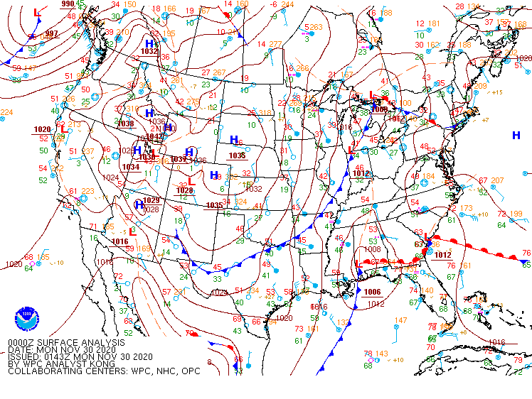
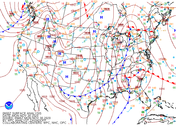
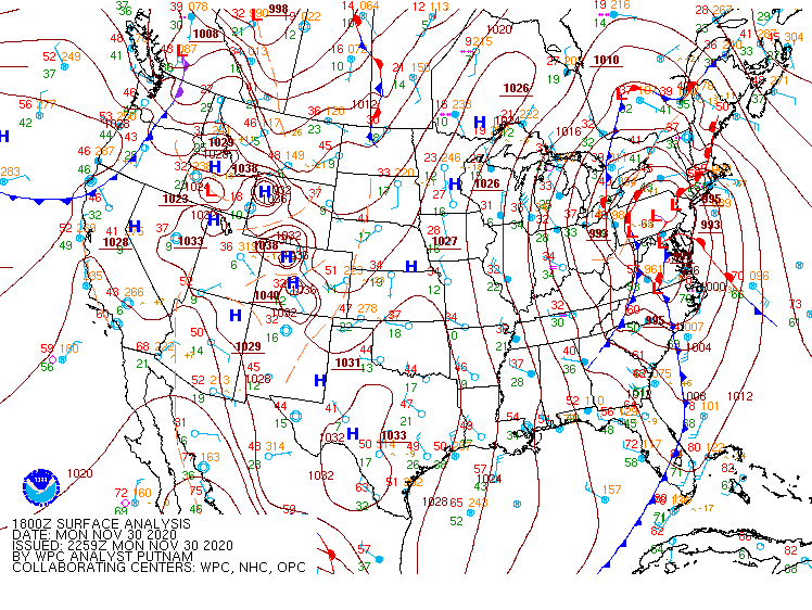
Surface Charts from WPC.
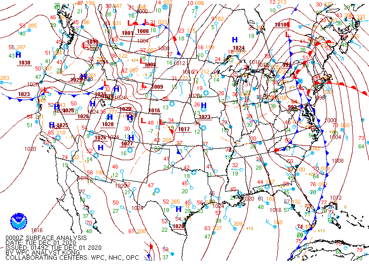
30 November 00Z - 01 December 06Z Surface Maps
 |
 |
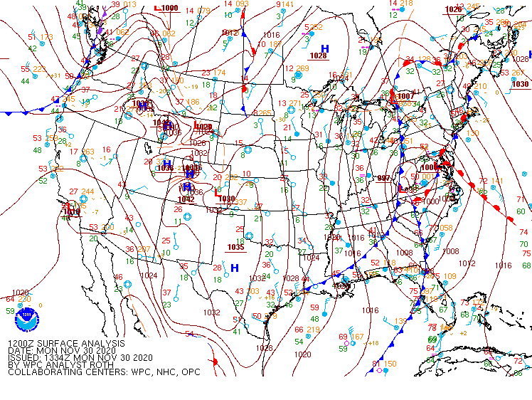 |
| Figure 1: 30 November 00Z SFC Chart | Figure 2: 30 November 06Z SFC Chart | Figure 3: 30 November 12Z SFC Chart |
 |
 |
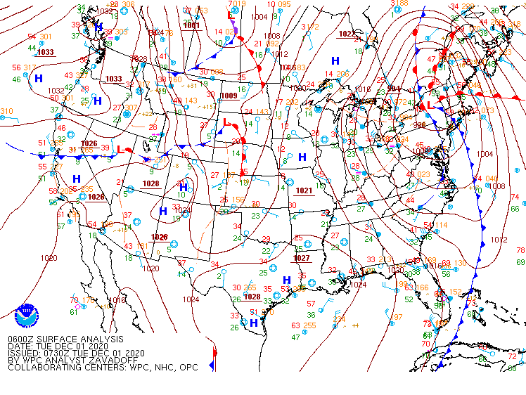 |
| Figure 4: 30 November 18Z SFC Chart | Figure 5: 01 December 00Z SFC Chart | Figure 6: 01 December 06Z SFC Cart |
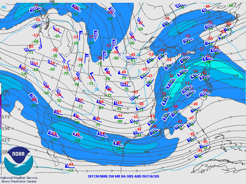
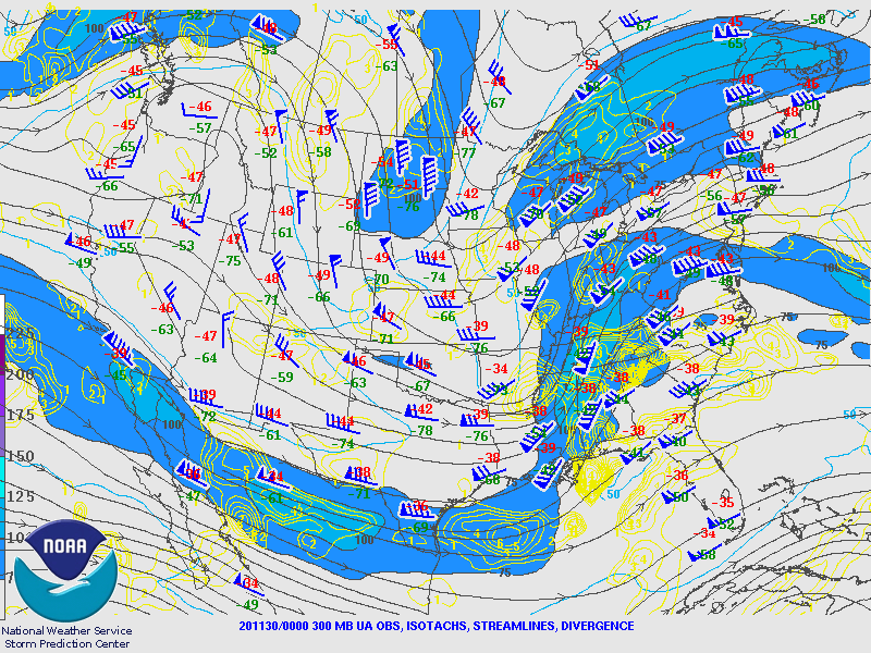
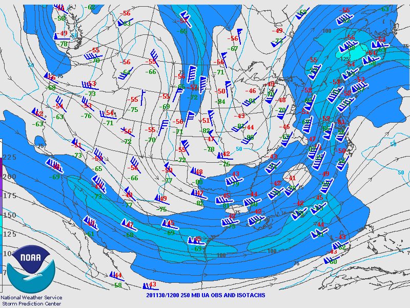
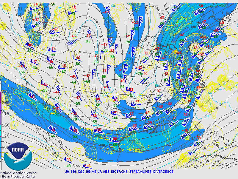
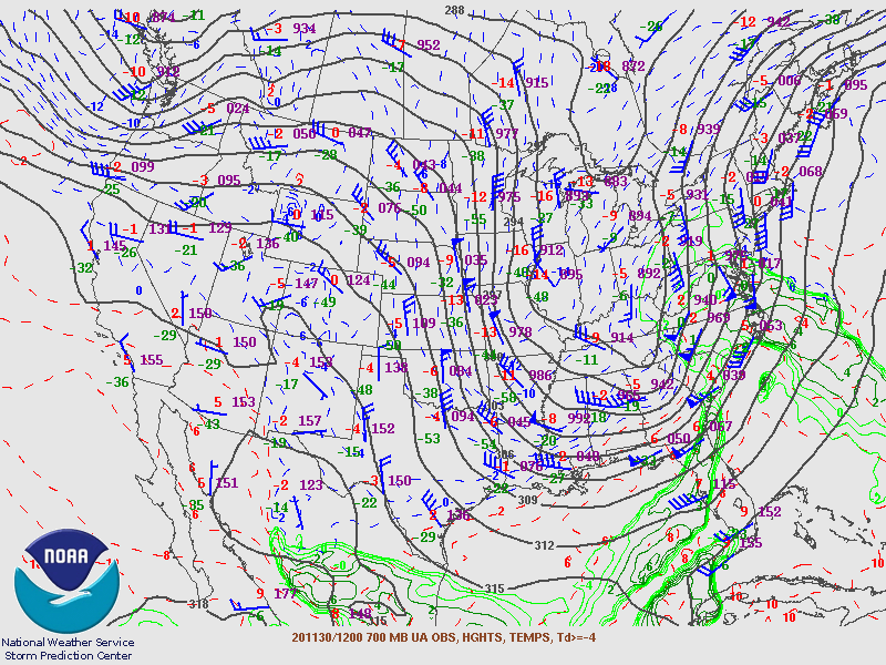
Upper Air Maps from SPC.
30 November 2020 00Z Upper Air Maps
 |
 |
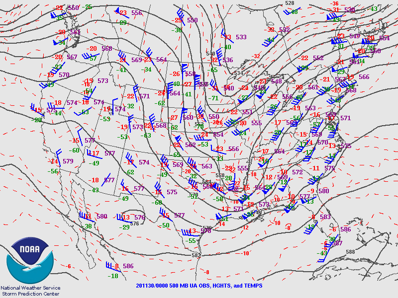 |
| Figure 4: 250MB | Figure 5: 300MB | Figure 6: 500MB |
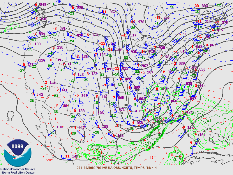 |
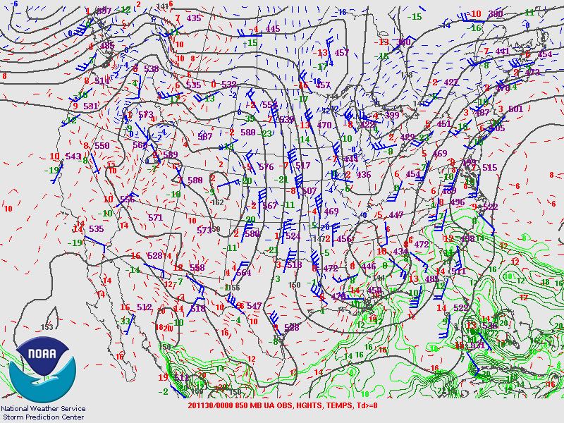 |
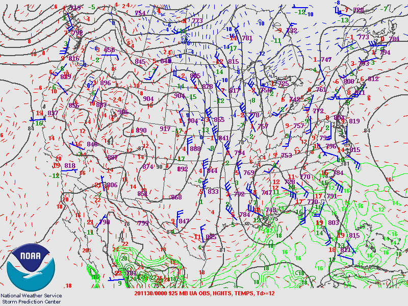 |
| Figure 4: 700MB | Figure 5: 850MB | Figure 6: 925MB |
30 November 2020 12Z
 |
 |
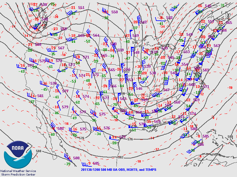 |
| Figure 7: 250MB | Figure 8: 300MB | Figure 9: 500MB |
 |
 |
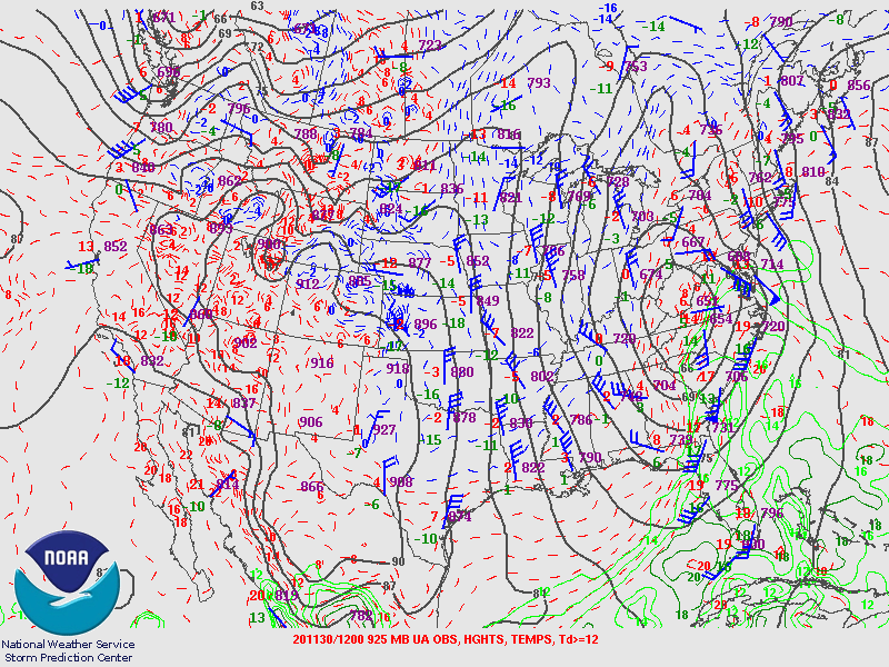 |
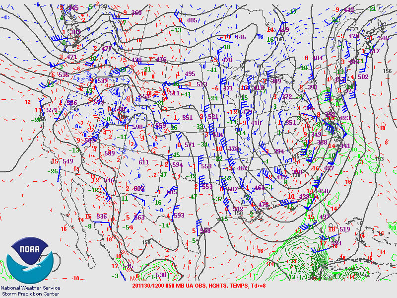
| Figure 10: 700MB | Figure 11: 850MB |
Figure 12: 925MB |
01 December 2020 00Z
.gif) |
.gif) |
.gif) |
| Figure 7: 250MB | Figure 8: 300MB | Figure 9: 500MB |
.gif) |
.gif) |
.gif) |
| Figure 7: 700MB | Figure 8: 850MB | Figure 9: 925MB |
 |
Media use of NWS Web News Stories is encouraged! Please acknowledge the NWS as the source of any news information accessed from this site. |
|