Overview
|
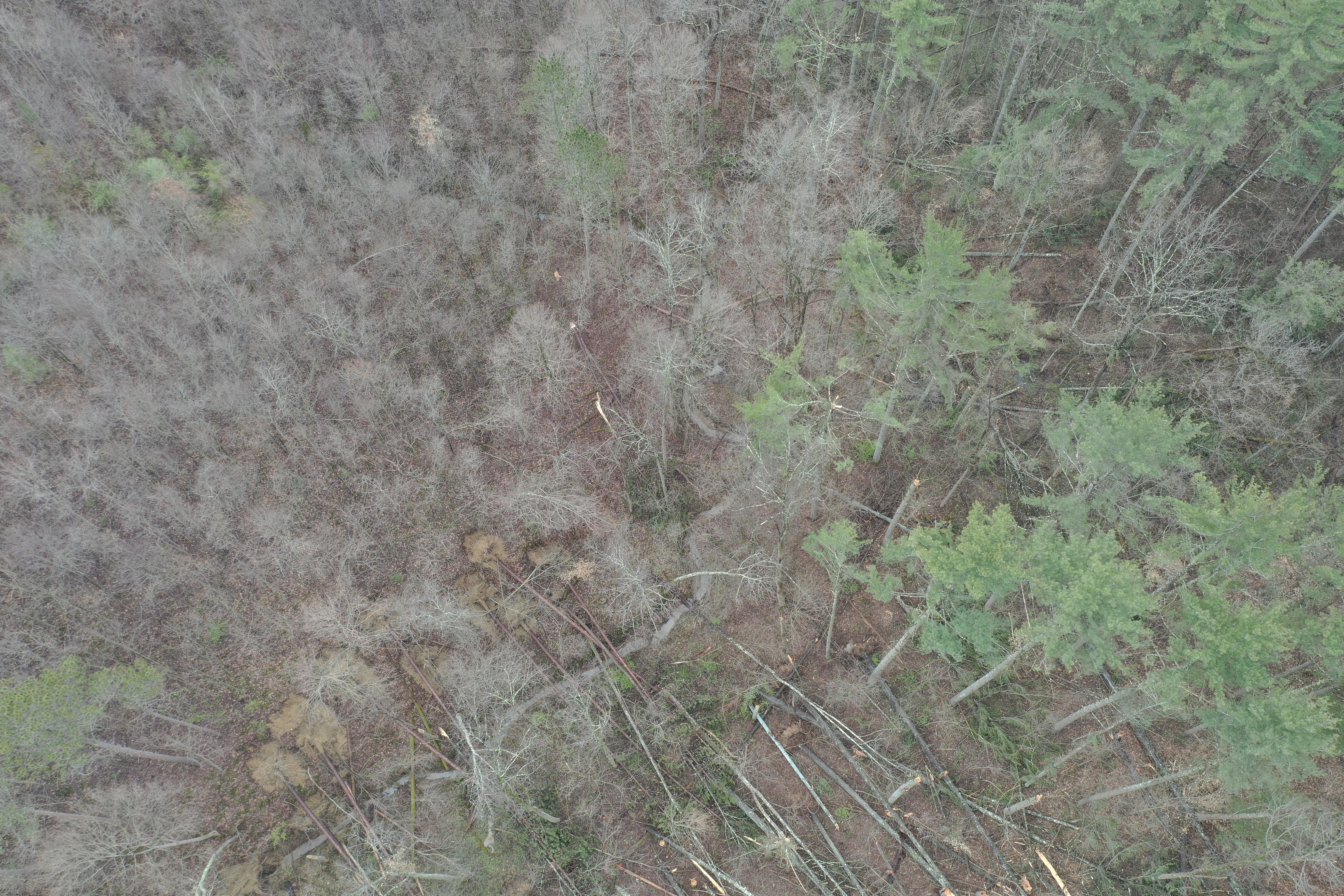
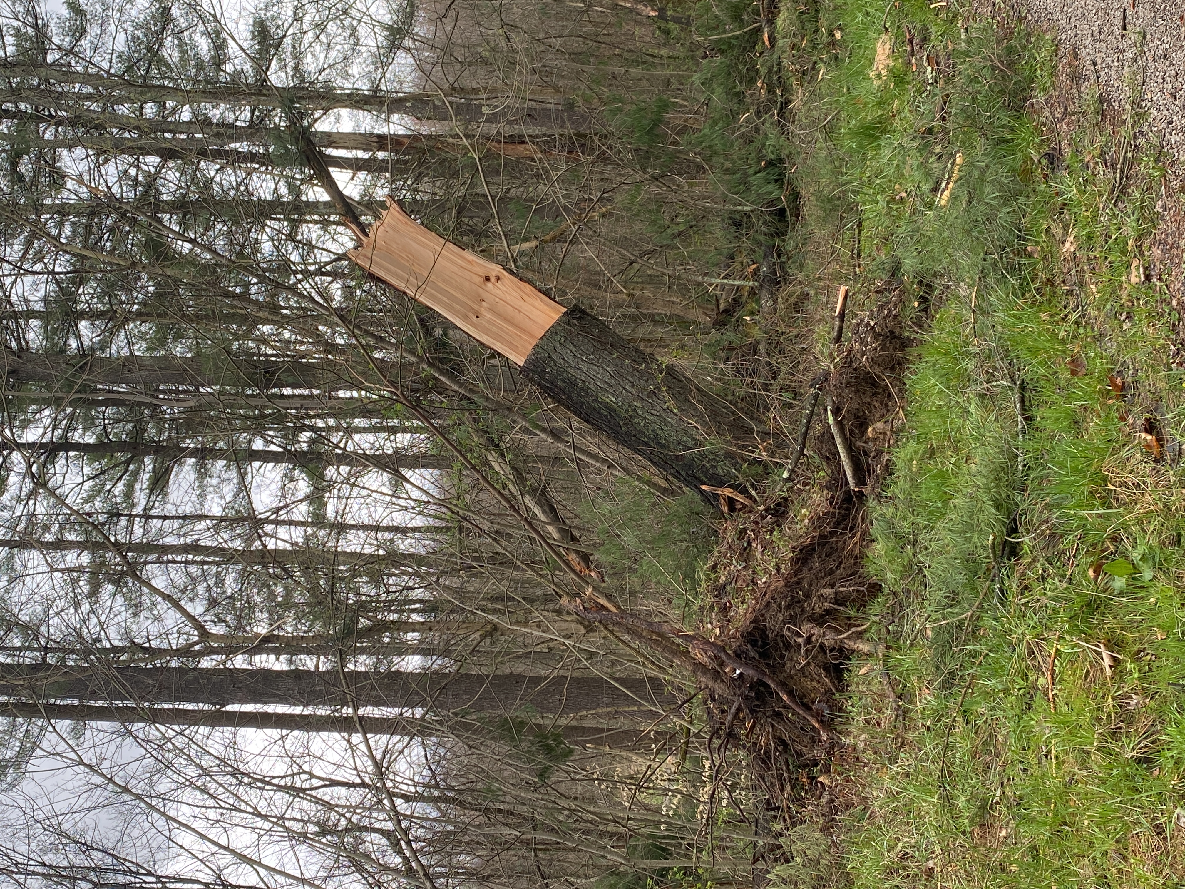
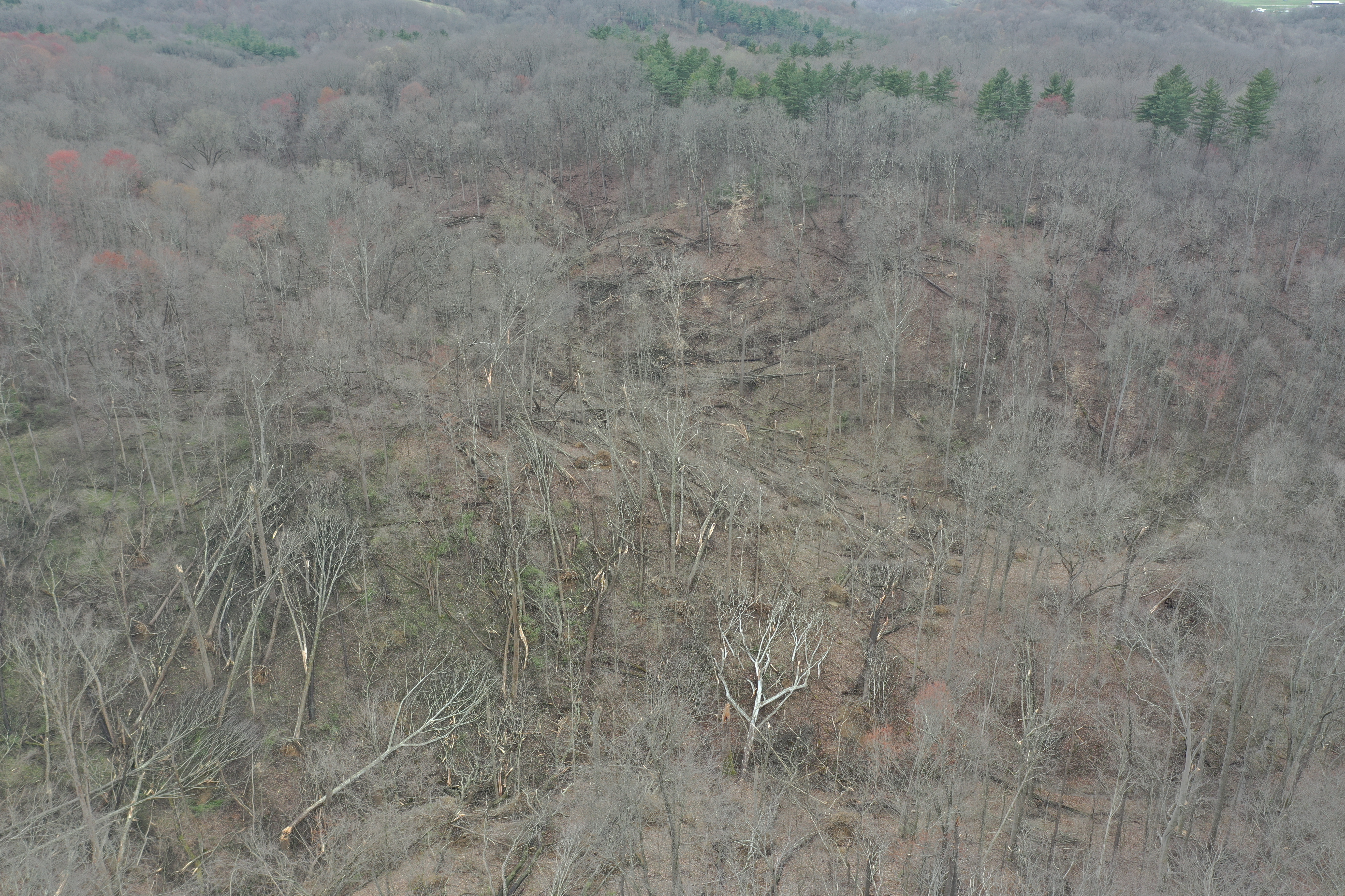
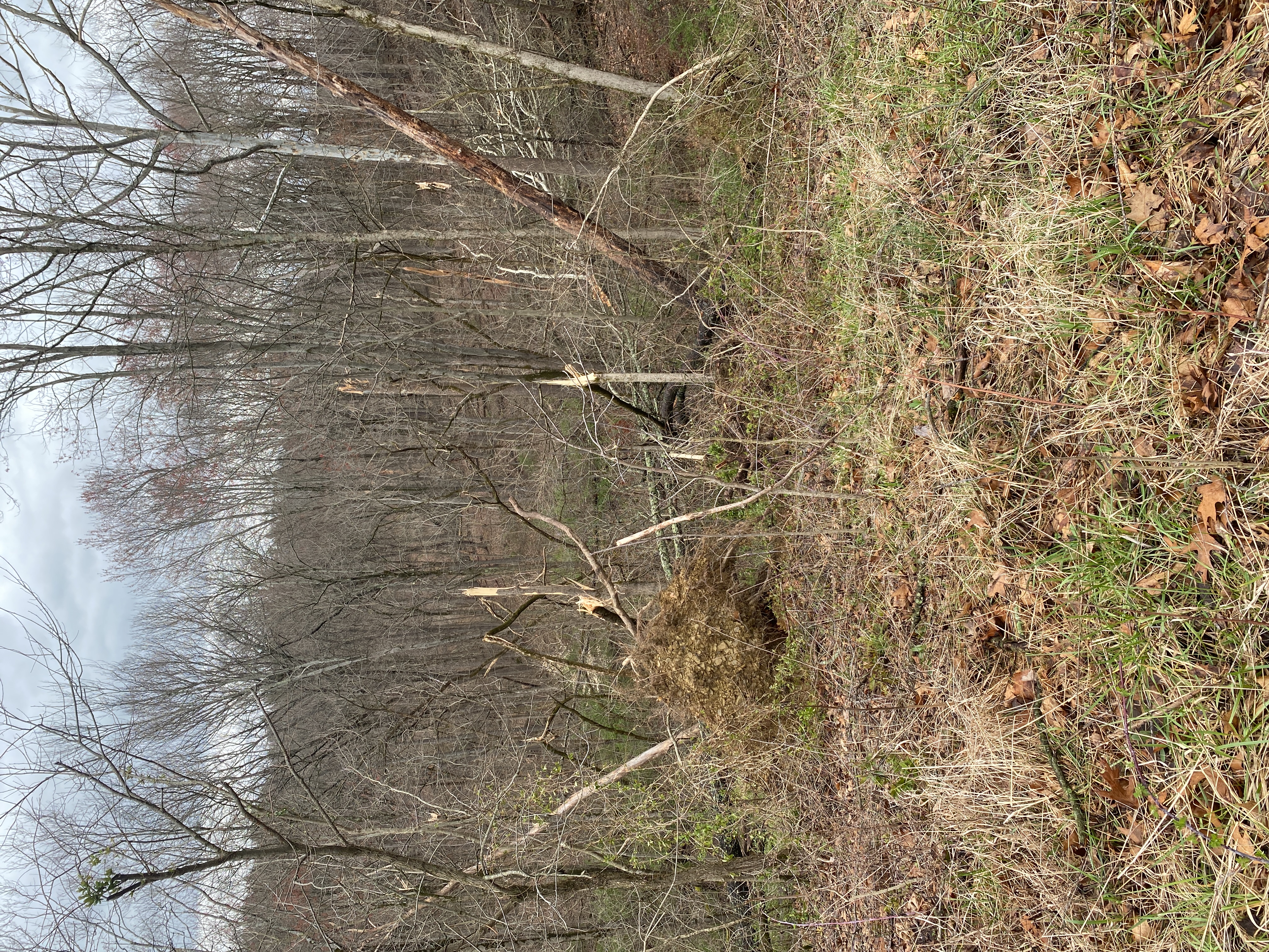
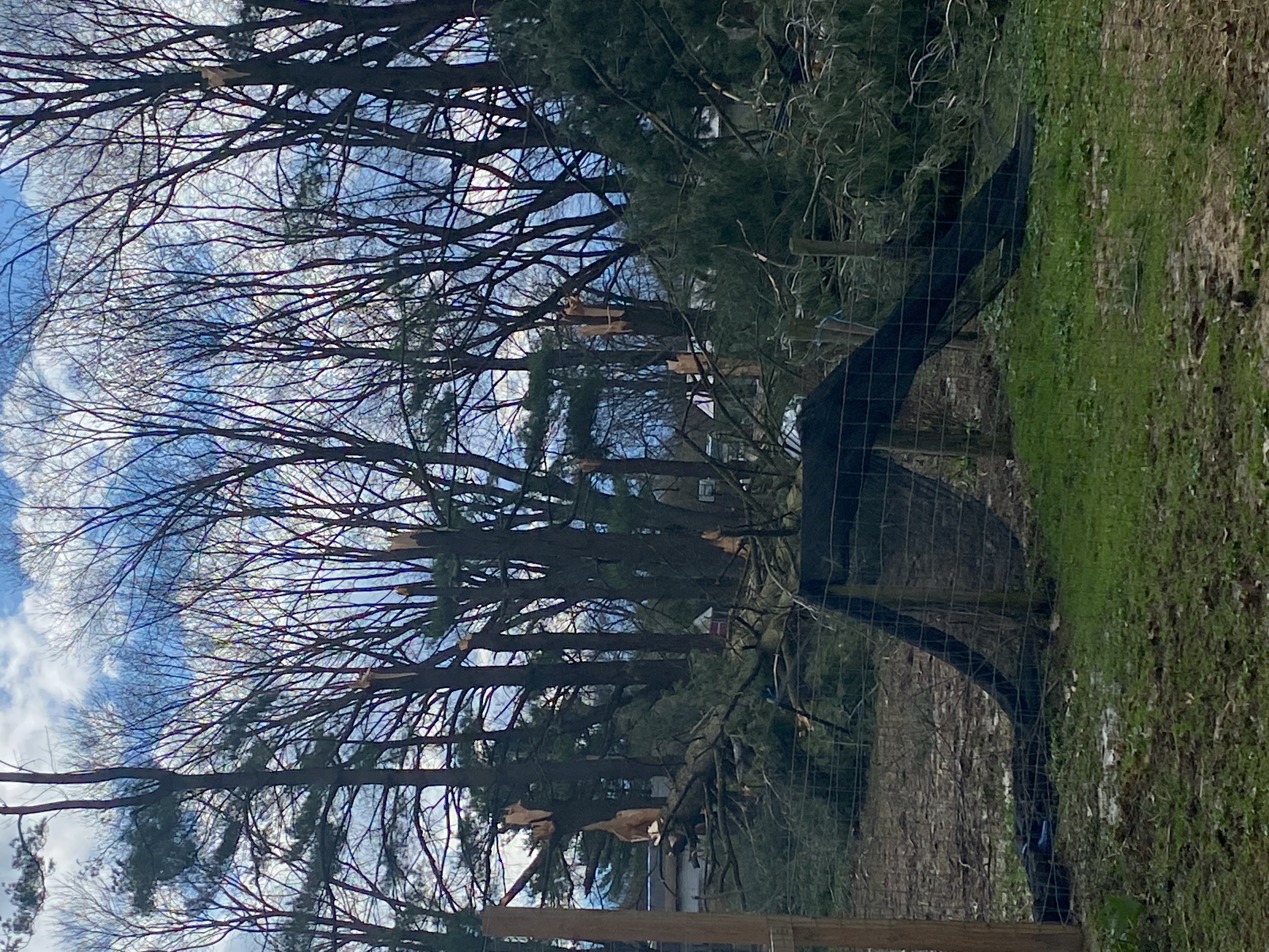
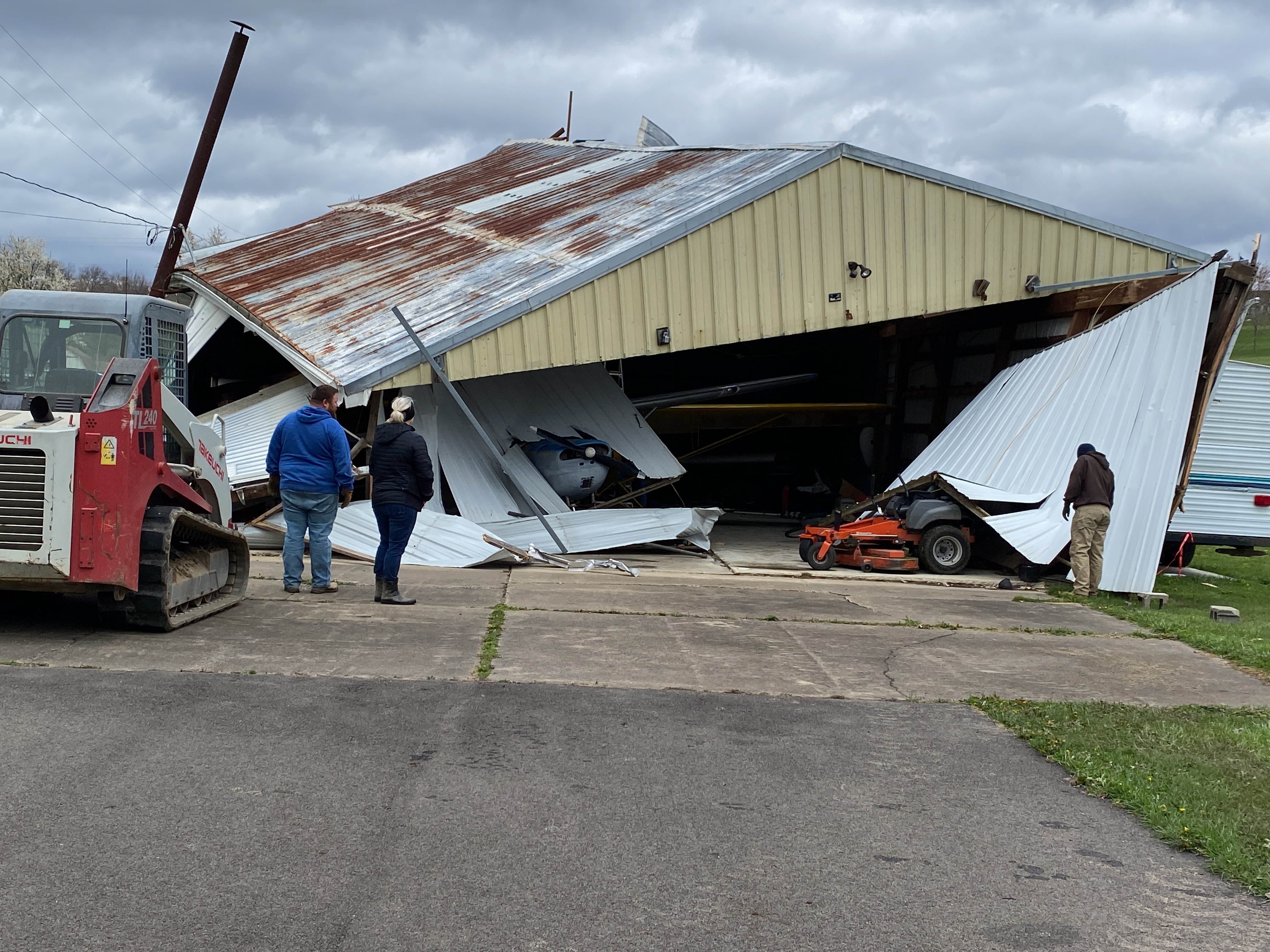
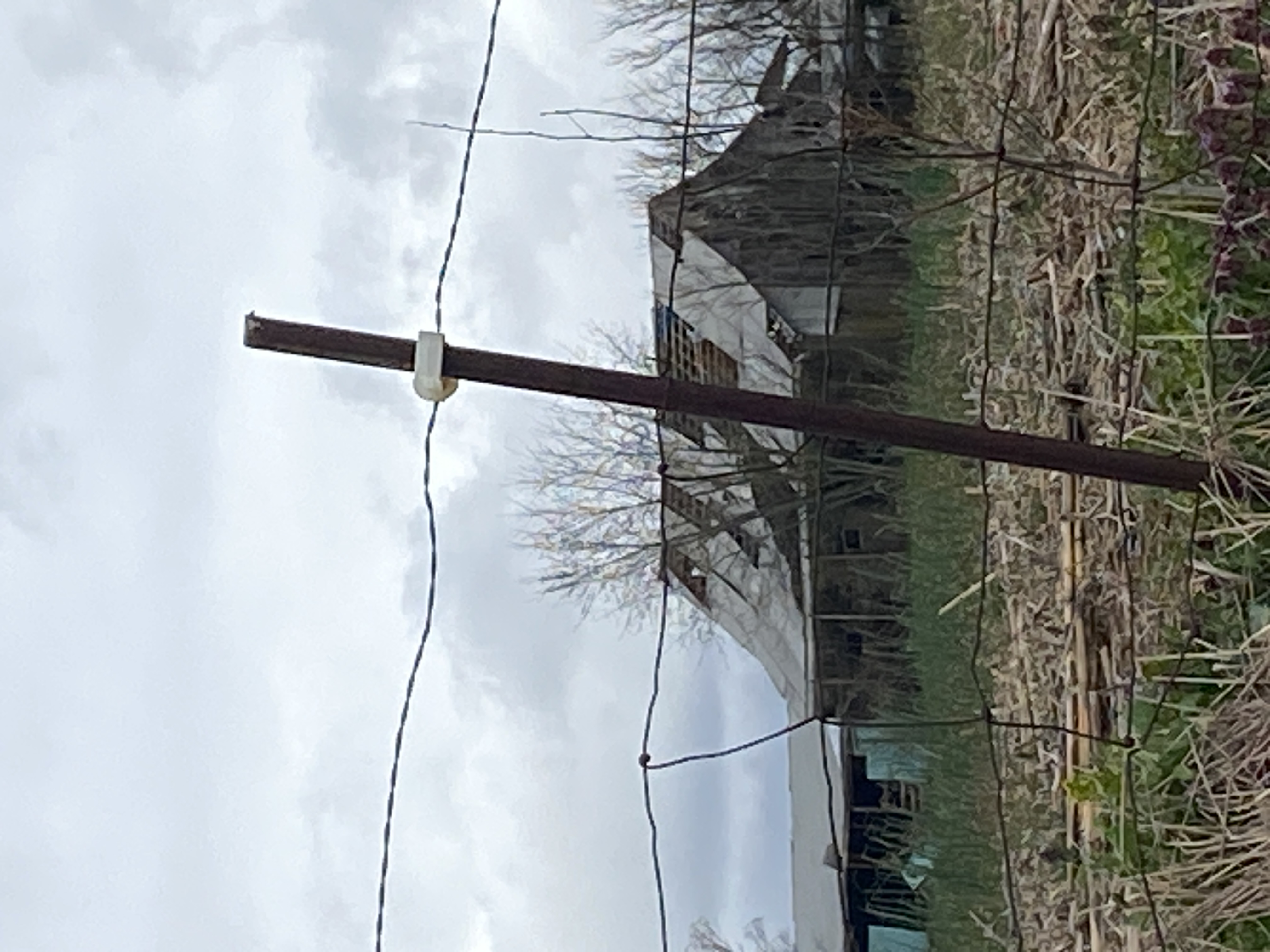
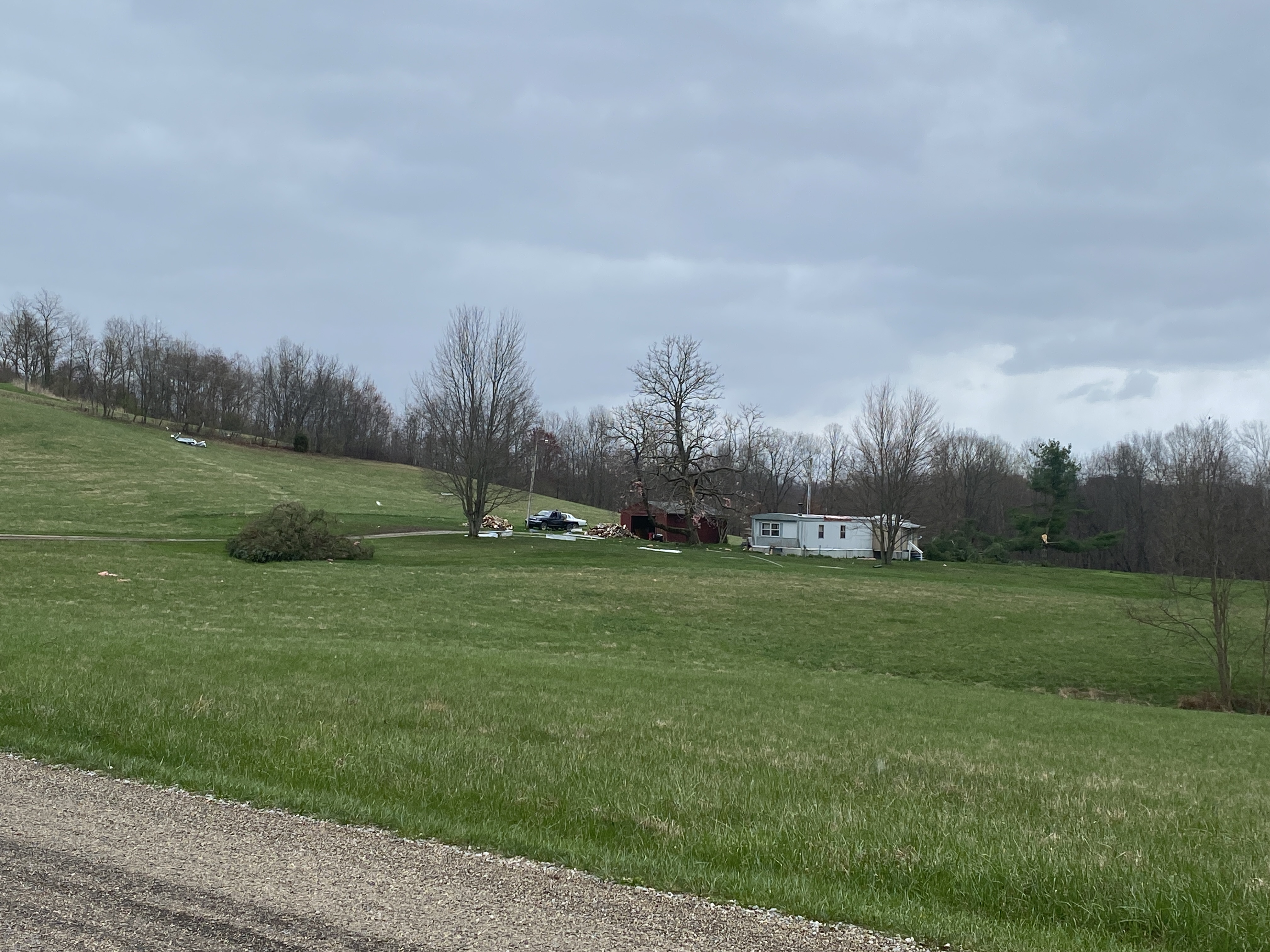
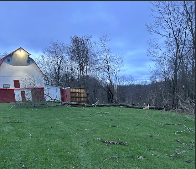
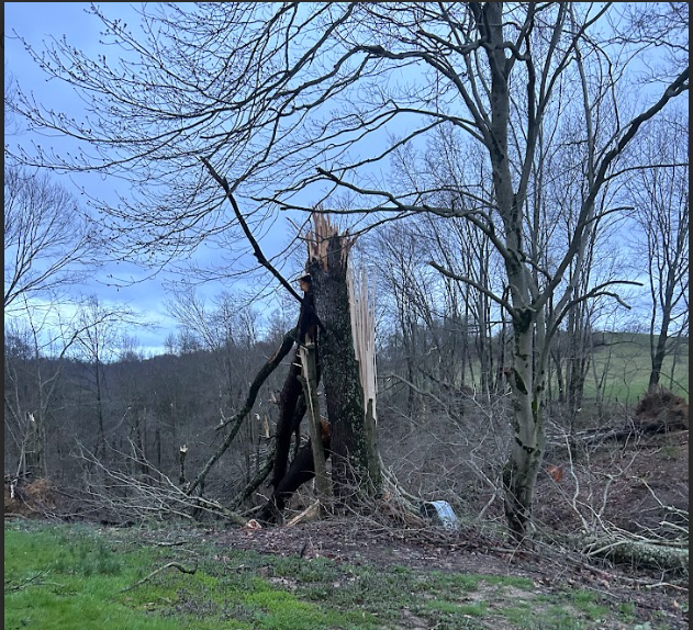
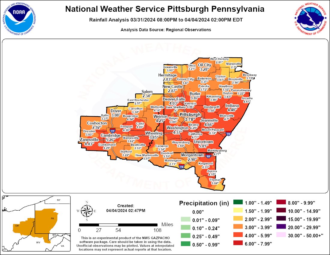
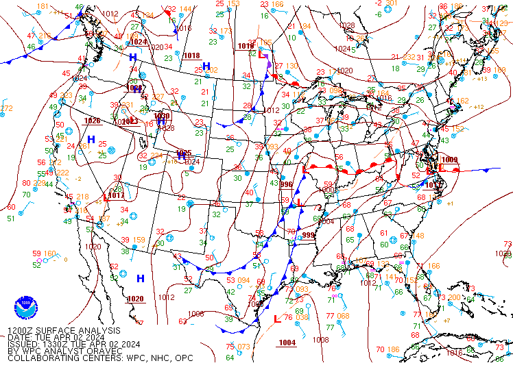
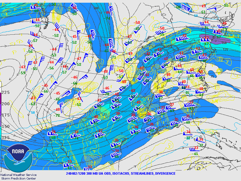
During the day of April 2nd 2024, a strengthening surface low pressure system took shape over the Mid MS River Valley as the low center developed over central IL. A prominent boundary then developed just north of the OH River and stretched from IL over to southwest PA. This surface boundary remained in place through the day as a strong jet streak tracked northeast into the OH Valley and remained prevalent through the day and into the overnight period. Thus, the forcing that was in place combined with strong southerly moist flow lead to precipitable water values between 1.25 to 1.50 across the area for just about the entire period of concern. All of these ingredients lead to prolonged periods of rainfall and eventually lead to substantial flooding across the area. To boot, when the better upper level support and surface parameters developed, severe thunderstorms began in western OH and IN and moved east into the Pittsburgh forecast area. Thus, severe thunderstorm and tornado warnings were issued for Muskingum, Guernsey and Coshocton counties. These locations, Muskingum and Guernsey did receive tornado damage that ranged from EF0 to EF1. The environment into the affected counties was less supportive storm development than to the west but was enough to keep a storm going east into Guernsey County. |
 Tornado Watch |
Tornadoes
|
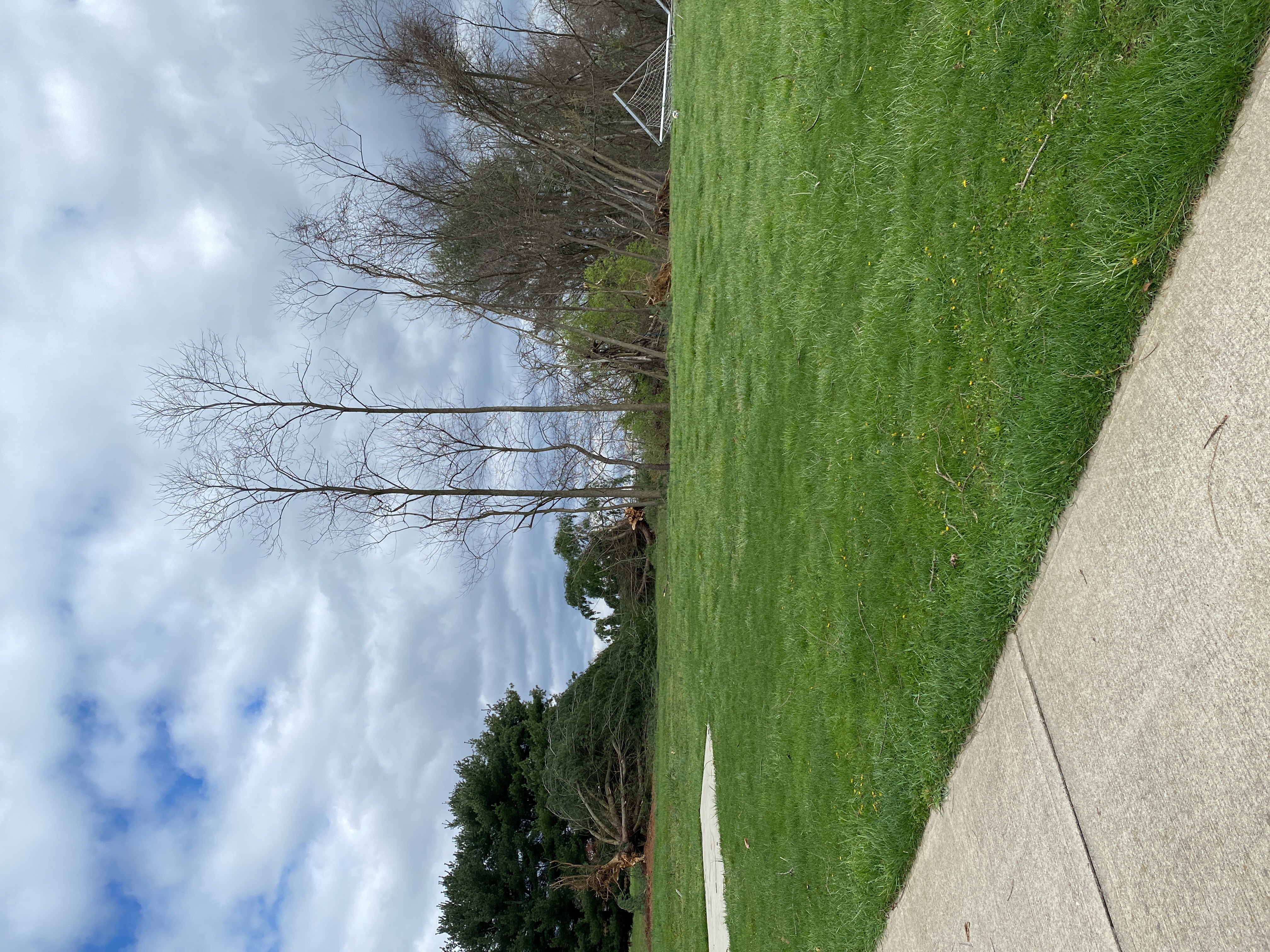
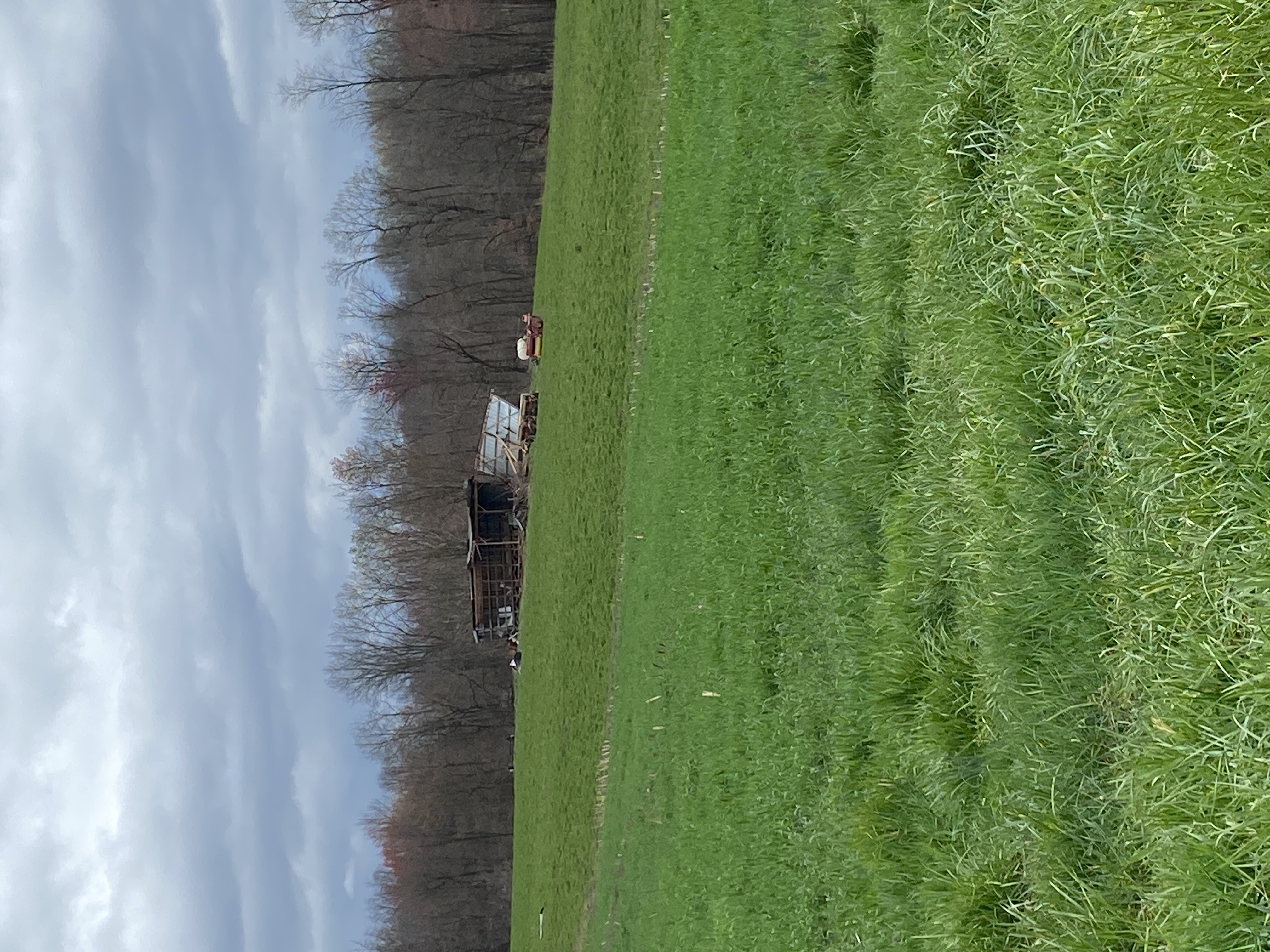
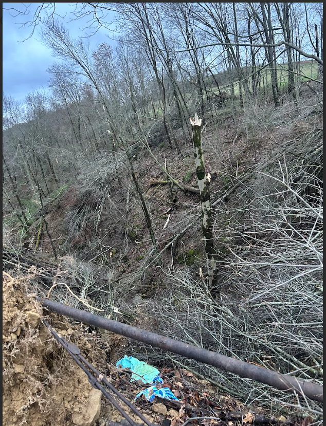
Tornado - Chandlersville
Track Map 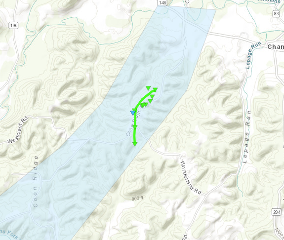 
Downloadable KMZ File |
||||||||||||||||
|
||||||||||||||||
|
Tornado - North Zanesville
Track Map 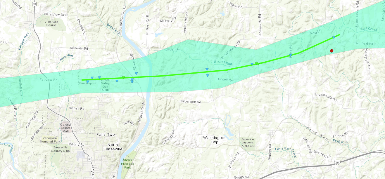
Downloadable KMZ File |
||||||||||||||||
|
||||||||||||||||
The Enhanced Fujita (EF) Scale classifies tornadoes into the following categories:
| EF0 Weak 65-85 mph |
EF1 Moderate 86-110 mph |
EF2 Significant 111-135 mph |
EF3 Severe 136-165 mph |
EF4 Extreme 166-200 mph |
EF5 Catastrophic 200+ mph |
 |
|||||
|
Tornado - Highland Township
Track Map 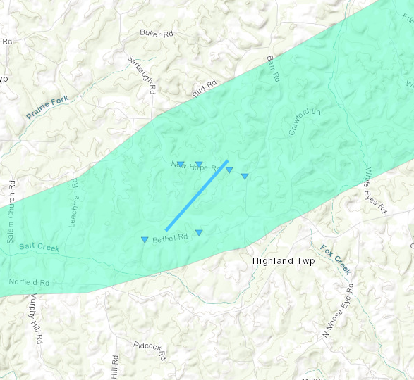
Downloadable KMZ File |
||||||||||||||||
|
||||||||||||||||
|
Tornado - Indian Camp Run
Track Map 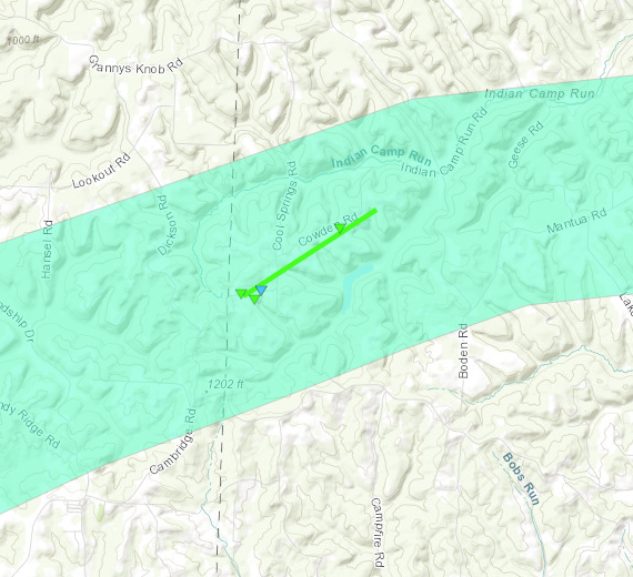
Downloadable KMZ File |
||||||||||||||||
|
||||||||||||||||
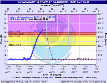
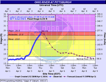
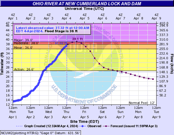
Flooding
The crests at these river points along the Monongahela and the Ohio Rivers were a couple days after the event.
Hydrographs
 |
 |
 |
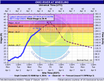 |
| Braddock Lock and Dam Monongahela River Point | Point State Park Ohio River Point | New Cumberland Lock and Dam | Wheeling Ohio River Point |
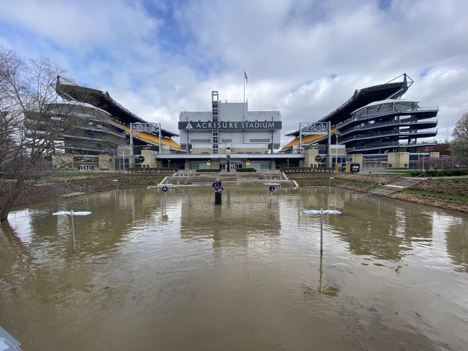
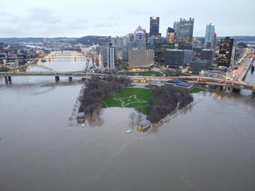
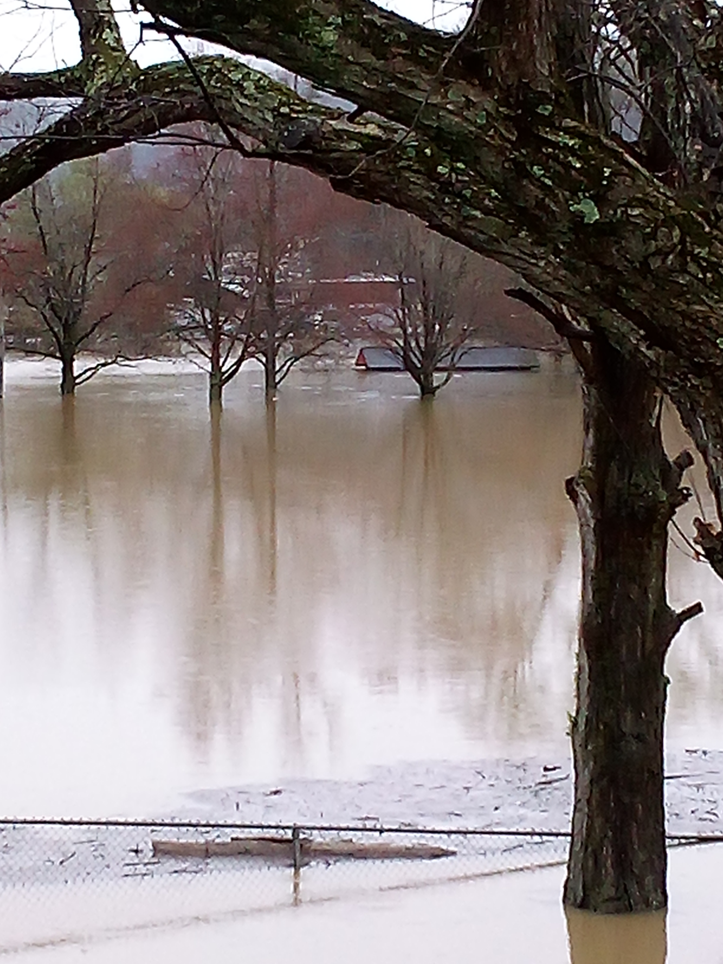
Photos
.jpg) |
 |
 |
 |
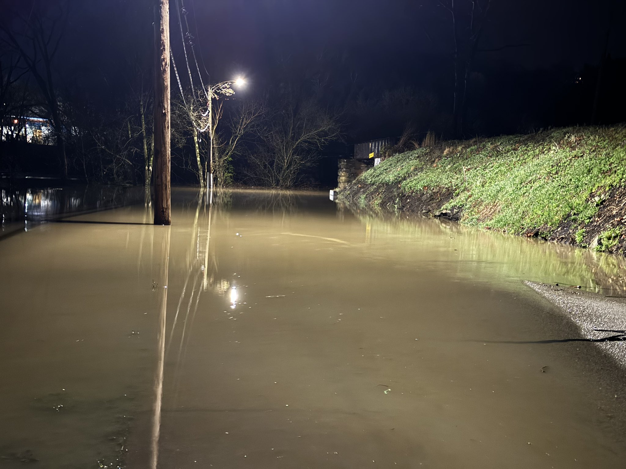
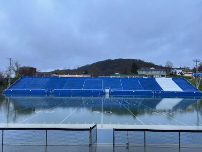
| Pittsburgh, PA Credit: Ed Thompson |
Pittsburgh, PA Credit: Ed Thompson |
Pittsburgh, PA Credit: Mitchell Nagy |
Powhatan Point, OH Credit: Jeff Oechslein |
 |
 |
 |
| California PA Credit: Nick Wilkes |
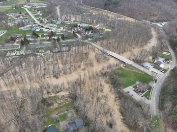
Cambridge OH Credit: Whitetail Drone Service |
East Liverpool OH Credit: Eric Wilhelm |
Radar
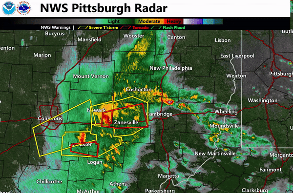 |
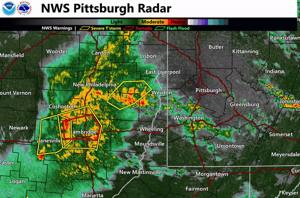 |
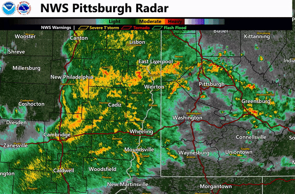 |
| Radar 1/3 | Radar 2/3 | Radar 3/3 |
Storm Reports
Preliminary Local Storm Report...Summary
National Weather Service Pittsburgh PA
756 PM EDT Wed Apr 03 2024
..TIME... ...EVENT... ...CITY LOCATION... ...LAT.LON...
..DATE... ....MAG.... ..COUNTY LOCATION..ST.. ...SOURCE....
..REMARKS..
0530 PM Flood Lore City 39.98N 81.46W
04/01/2024 Guernsey OH Newspaper
Flooded fields and streams out of banks near Lore City.
0530 PM Flood Lore City 39.98N 81.46W
04/01/2024 Guernsey OH Newspaper
0745 AM Flood Summerfield 39.80N 81.34W
04/02/2024 Noble OH Dept of Highways
SR 146 and SR 513 closed due to flooding
0748 AM Flood Senecaville 39.93N 81.46W
04/02/2024 Guernsey OH Co-Op Observer
Report of flooded roads in Senecaville. 2.58 inch of
rain between yesterday and today.
0800 AM Flood 2 SSW Batesville 39.89N 81.30W
04/02/2024 Noble OH Dept of Highways
SR 513 closed due to flooding along Seneca Fork of
Wills Creek
0800 AM Flood 1 NW Kipling 40.01N 81.52W
04/02/2024 Guernsey OH Dept of Highways
SR 265 closed due to flooding
0800 AM Flood Kings Mine 39.99N 81.48W
04/02/2024 Guernsey OH Dept of Highways
SR 265 closed due to flooding along Hawkins Run and
Leatherwood Creek
0800 AM Flood 2 SW Antrim 40.10N 81.38W
04/02/2024 Guernsey OH Dept of Highways
US 22 closed due to flooding along Brushy Fork
0800 AM Flood 2 SE Middlebourne 40.02N 81.31W
04/02/2024 Guernsey OH Dept of Highways
SR 513 closed due to flooding along Salt Fork
0800 AM Flood Winterset 40.10N 81.42W
04/02/2024 Guernsey OH Dept of Highways
US 22 closed due to flooding along Brushy Fork
0800 AM Flood Batesville 39.91N 81.29W
04/02/2024 Noble OH Dept of Highways
SR 147 closed due to flooding of Beaver Creek
0815 AM Flood Baileys Mills 39.96N 81.23W
04/02/2024 Belmont OH Dept of Highways
SR 265 closed due to flooding of Leatherwood Creek
0830 AM Flood 1 SE Captina 39.88N 80.86W
04/02/2024 Belmont OH Dept of Highways
SR 148 closed due to flooding of Captina Creek
0830 AM Flood 2 NE New Castle 39.91N 81.04W
04/02/2024 Belmont OH Dept of Highways
SR 148 closed due to flooding of Captina Creek
0845 AM Flood 1 WNW Quaker City 39.97N 81.31W
04/02/2024 Guernsey OH Dept of Highways
SR 265 closed due to flooding along Leatherwood Creek
0845 AM Flood Sarahsville 39.81N 81.47W
04/02/2024 Noble OH Dept of Highways
SR 147 and SR 146 closed due to flooding
0845 AM Flood Quaker City 39.97N 81.30W
04/02/2024 Guernsey OH Dept of Highways
SR 265 closed due to flooding along Leatherwood Creek
0845 AM Flood 1 SSW Pleasant City 39.90N 81.55W
04/02/2024 Noble OH Dept of Highways
SR 146 closed due to flooding of Buffalo Creek
0900 AM Flood Lore City 39.99N 81.46W
04/02/2024 Guernsey OH Dept of Highways
SR 285 closed due to flooding along Infirmary Run and
Leatherwood Creek
0928 AM Flash Flood Moon 40.51N 80.24W
04/02/2024 Allegheny PA Public
Several streams out of their banks in the Moon Township
and Robinson areas
0945 AM Flood 1 NNE West Chester 40.25N 81.34W
04/02/2024 Tuscarawas OH Dept of Highways
SR 258 closed due to flooding along Laurel Creek
0945 AM Flood 1 W Pleasant Grove 39.95N 81.98W
04/02/2024 Muskingum OH Dept of Highways
Interstate 70 eastbound lane reduction due to minor
flooding
1000 AM Flood 2 WNW Ross Township 40.54N 80.05W
04/02/2024 Allegheny PA Dept of Highways
Reis Run Rd closed due to flooding along Lowries Run
and Harts Run
1000 AM Flood 4 SSW St. Clairsville 40.02N 80.94W
04/02/2024 Belmont OH Dept of Highways
SR9 closed due to flooding along Neffs Run and McMahon
Creek
1005 AM Flash Flood 2 WNW Carnot-Moon 40.53N 80.24W
04/02/2024 Allegheny PA NWS Employee
Flaughherty Run out of its banks. Water and debris
flowing across the road at a few locations.
1029 AM Flood Bethany 40.21N 80.56W
04/02/2024 Brooke WV Public
Flooding at Bethany College as well as route 67 heading
into bethany
1030 AM Flash Flood Millvale 40.48N 79.97W
04/02/2024 Allegheny PA 911 Call Center
Several roads flooded
1030 AM Flood Woodville 40.38N 80.09W
04/02/2024 Allegheny PA Law Enforcement
Scrubgrass Rd closed due to flooding along Scrubgrass
Run
1030 AM Flash Flood Ross Township 40.53N 80.02W
04/02/2024 Allegheny PA 911 Call Center
several roads flooded
1030 AM Flood 1 S Sun Valley 40.43N 80.56W
04/02/2024 Hancock WV 911 Call Center
North 12th street is flooded and closed.
1030 AM Flood Sun Valley 40.45N 80.58W
04/02/2024 Hancock WV 911 Call Center
Turkey Foot Road closed due to flooding.
1030 AM Flood 1 SSE Sun Valley 40.44N 80.56W
04/02/2024 Hancock WV 911 Call Center
Greentree Lane closed due to flooding.
1030 AM Flood 1 SSW Marion Center 40.76N 79.05W
04/02/2024 Indiana PA Public
Creeks and streams out of banks.
1030 AM Flood 1 S Marion Center 40.76N 79.05W
04/02/2024 Indiana PA Public
Creek/stream out of banks
1031 AM Flash Flood Hampton Township 40.59N 79.95W
04/02/2024 Allegheny PA 911 Call Center
Several roads flooded
1032 AM Flash Flood Shaler Township 40.52N 79.96W
04/02/2024 Allegheny PA 911 Call Center
Several roads flooded
1033 AM Flash Flood Sharpsburg 40.50N 79.92W
04/02/2024 Allegheny PA 911 Call Center
Route 28 south near Sharpsburg is starting to flood
1045 AM Flood Brownsville 40.02N 79.90W
04/02/2024 Fayette PA 911 Call Center
Ten houses experiencing flooding along Water Street
1045 AM Flood Brownsville 40.02N 79.89W
04/02/2024 Fayette PA 911 Call Center
Ten houses along Water Street experiencing flooding
1045 AM Flood 1 SW Brownsville 40.02N 79.90W
04/02/2024 Fayette PA Public
10 houses along Water Street in Brownsville Borough
flooded.
1046 AM Flash Flood 1 ESE Baldwin 40.36N 79.95W
04/02/2024 Allegheny PA Public
streets run road closed due to flooding
1055 AM Flood Wheeling 40.08N 80.70W
04/02/2024 Ohio WV Trained Spotter
Wheeling Creek out of its banks and impacting the
Krogers parking lot near Mt. Dechantal Road.
1057 AM Flood 2 WSW Eighty Four 40.16N 80.17W
04/02/2024 Washington PA Public
Flooding on Zediker Station Road
1057 AM Flood 1 WSW Cokeburg 40.09N 80.08W
04/02/2024 Washington PA Public
route 40 flooded in a few locations
1100 AM Flood Dime 40.66N 79.53W
04/02/2024 Armstrong PA 911 Call Center
Flooded roadways within Bethel Township.
1100 AM Flood 1 SE Hungry Hollow 40.63N 79.55W
04/02/2024 Armstrong PA 911 Call Center
Flooded roadways within Park Township.
1100 AM Flood Atwood 40.75N 79.26W
04/02/2024 Armstrong PA 911 Call Center
A number of flooded roadways.
1100 AM Flood Lookabough Corners 40.67N 79.60W
04/02/2024 Armstrong PA 911 Call Center
Flooded roadways in Gilpin Township. Impacts noted in
pictures along Route 66.
1101 AM Flood 1 ESE Weircrest 40.44N 80.58W
04/02/2024 Hancock WV 911 Call Center
Flooding on roads near Kings Creek
1102 AM Flood Hopewell 39.47N 80.10W
04/02/2024 Marion WV Public
kane road closed between broadhead roead and laird
drive due to flooding
1115 AM Flash Flood 1 ESE Canonsburg 40.26N 80.17W
04/02/2024 Washington PA Public
Flooding on Route 980
1115 AM Flash Flood Oakdale 40.40N 80.19W
04/02/2024 Allegheny PA 911 Call Center
The Oakdale Fire Department building was taking on
water, and equipment was being evacuated.
1115 AM Flood Oakdale 40.40N 80.19W
04/02/2024 Allegheny PA Public
Home/business flooded as Oakdale fire department
building taking on water. Equipment being evacuated.
1125 AM Flood 3 S Ford Cliff 40.71N 79.53W
04/02/2024 Armstrong PA Public
Route 66 near Crooked Creek Dam Road is flooded due to
an overflowing stream
1200 PM Flood 2 NNE Curtisville 40.67N 79.83W
04/02/2024 Butler PA Public
Flooding on Cherry Valley Rd along Bull Creek, small
streams overflowing banks around Saxonburg
1200 PM Flood 4 WSW Zelienople 40.76N 80.22W
04/02/2024 Beaver PA Dept of Highways
Brush Creek Rd closed due to flooding along Brush
Creek. Road remains closed at 6pm as water is high
1200 PM Flash Flood 1 S Blawnox 40.47N 79.86W
04/02/2024 Allegheny PA Dept of Highways
Verona Rd closed due to flooding of Sandy Creek
1200 PM Flood 5 ENE New Martinsville 39.68N 80.78W
04/02/2024 Wetzel WV Dept of Highways
Proctor Creek Rd flooded along Proctor Creek. Water
remained over the road at 630 pm
1200 PM Flood 2 SW Saxonburg 40.74N 79.86W
04/02/2024 Butler PA Public
Creek/stream out of banks. Intersection of Cherry
Valley Rd and Victory Rd in Clinton Twp flooded.
1237 PM Flood 3 SSW West Middletown 40.21N 80.44W
04/02/2024 Washington PA Public
Flooding on Seminary Road
1245 PM Flood 3 SW Latrobe 40.29N 79.42W
04/02/2024 Westmoreland PA Public
Minor street flooding
0130 PM Flash Flood 1 N Tarentum 40.62N 79.76W
04/02/2024 Allegheny PA Dept of Highways
Bull Creek Rd closed due to flooding along Bull Creek
between Metz Rd and Ridge Rd
0201 PM Flood 1 SW Creekside 40.69N 79.18W
04/02/2024 Indiana PA Public
0545 PM Flood 1 SE North Sewickley 40.83N 80.26W
04/02/2024 Beaver PA 911 Call Center
Report of Country Club Drive closed in North Sewickley
due to flooding.
0600 PM Flash Flood Belle Valley 39.79N 81.56W
04/02/2024 Noble OH Dept of Highways
State Road 821 closed due to flooding.
0600 PM Flash Flood 1 SSE Bethany 40.19N 80.55W
04/02/2024 Brooke WV Dept of Highways
Castlemans Run Road closed due to flooding.
0600 PM Flash Flood Stafford 39.71N 81.28W
04/02/2024 Monroe OH Public
State Road 145 closed due to flooding.
0600 PM Flash Flood 7 ESE Dexter City 39.62N 81.36W
04/02/2024 Noble OH Dept of Highways
State Roads 564 and 145 closed due to flooding.
0600 PM Flash Flood 1 NNE Amsterdam 40.48N 80.92W
04/02/2024 Jefferson OH Emergency Mngr
State Road 164 was closed due to flooding.
0600 PM Flash Flood 4 NNE Wilson 39.91N 81.04W
04/02/2024 Belmont OH Dept of Highways
State Road 148 closed due to flooding.
0600 PM Flash Flood 4 S Stafford 39.66N 81.28W
04/02/2024 Noble OH Dept of Highways
State Road 260 closed due to flooding.
0600 PM Flash Flood 3 S Neffs 39.99N 80.81W
04/02/2024 Belmont OH Dept of Highways
State Road 147 closed due to flooding.
0600 PM Flash Flood Pleasant City 39.90N 81.55W
04/02/2024 Guernsey OH Dept of Highways
State Roads 146 and 821 closed due to flooding.
0600 PM Flash Flood 2 S Woodsfield 39.73N 81.11W
04/02/2024 Monroe OH Dept of Highways
State Road 26 closed due to flooding.
0600 PM Flash Flood 3 WSW Byesville 39.96N 81.59W
04/02/2024 Guernsey OH Dept of Highways
State road 660 is closed due to flooding.
0600 PM Flash Flood Triadelphia 40.05N 80.63W
04/02/2024 Ohio WV Broadcast Media
Flooding on Middle Creek was pushing large tree
branches onto bridges.
0630 PM Flash Flood 1 ESE Caldwell 39.74N 81.50W
04/02/2024 Noble OH Dept of Highways
State Roads 821 and 564 closed due to flooding.
0630 PM Flash Flood 6 S Graysville 39.58N 81.16W
04/02/2024 Monroe OH Dept of Highways
State Road 26 closed due to flooding.
0630 PM Flash Flood 1 SSW Clarington 39.77N 80.87W
04/02/2024 Monroe OH Dept of Highways
State Road 78 closed due to flooding.
0630 PM Flash Flood 3 WNW Powhatan Point 39.88N 80.86W
04/02/2024 Belmont OH Dept of Highways
State Road 148 closed due to flooding.
0630 PM Flash Flood 7 WSW Clarington 39.75N 80.98W
04/02/2024 Monroe OH Dept of Highways
State Road 78 closed due to flooding.
0700 PM Flash Flood 4 ESE Quaker City 39.96N 81.23W
04/02/2024 Belmont OH Dept of Highways
State Road 265 closed due to flooding.
0700 PM Flash Flood Batesville 39.91N 81.28W
04/02/2024 Noble OH Dept of Highways
State Roads 147 and 513 closed due to flooding.
0700 PM Flash Flood 1 W Empire 40.51N 80.64W
04/02/2024 Jefferson OH Dept of Highways
State Road 152 closed due to trees and debris on
highway from flooding.
0700 PM Flash Flood 2 ESE Bethany 40.19N 80.53W
04/02/2024 Brooke WV Emergency Mngr
Emergency manager quoted in Weirton Daily times stating
flooding led to the closings of state Route 67 at Camp
Run Road...Castleman Run Road and Pierce Run Road.
0700 PM Flash Flood 3 NNE New Cumberland 40.54N 80.58W
04/02/2024 Hancock WV Dept of Highways
Tomilson Run Park Road is closed.
0700 PM Flash Flood 3 N Weirton 40.44N 80.56W
04/02/2024 Hancock WV Broadcast Media
Kings Creek Road closed due to flooding.
0700 PM Flash Flood 6 SSE New Martinsville 39.59N 80.81W
04/02/2024 Wetzel WV Newspaper
Shortline Highway closed due to flooding.
0730 PM Flash Flood 4 SSW Summerfield 39.75N 81.36W
04/02/2024 Noble OH Dept of Highways
State Roads 724 and 260 closed due to flooding.
0900 PM Flash Flood 5 NNE Warsaw 40.40N 81.97W
04/02/2024 Coshocton OH Dept of Highways
State Road 60 closed due to high water.
0900 PM Flash Flood Lore City 39.99N 81.46W
04/02/2024 Guernsey OH Dept of Highways
State Roads 265 and 285 closed due to flooding.
0900 PM Flash Flood 1 S Freeport 40.20N 81.27W
04/02/2024 Harrison OH Dept of Highways
State Road 800 closed due to flooding.
0900 PM Flash Flood 1 WNW Nellie 40.35N 82.09W
04/02/2024 Coshocton OH Dept of Highways
State Road 715 closed due to high water.
0900 PM Flash Flood 4 W Kimbolton 40.15N 81.66W
04/02/2024 Guernsey OH Dept of Highways
State Road 658 is closed due to flooding.
0900 PM Flash Flood 4 NE Deersville 40.34N 81.14W
04/02/2024 Harrison OH Dept of Highways
State Road 646 closed due to flooding.
0900 PM Flash Flood 7 WNW Nellie 40.37N 82.19W
04/02/2024 Coshocton OH Dept of Highways
State Route 715 closed due to high water.
0900 PM Flash Flood 4 WNW Freeport 40.24N 81.34W
04/02/2024 Tuscarawas OH Dept of Highways
0900 PM Flash Flood 3 W Kimbolton 40.16N 81.62W
04/02/2024 Guernsey OH Dept of Highways
State Road 541 is closed due to flooding.
0909 PM Flood 1 SE Jacksonburg 39.52N 80.63W
04/02/2024 Wetzel WV Public
Minor street flooding
0922 PM Flood 1 E Bentleyville 40.12N 80.00W
04/02/2024 Washington PA Public
Home/business flooded
0930 PM Flash Flood 5 S Philo 39.80N 81.90W
04/02/2024 Muskingum OH Dept of Highways
State Road 60 is closed in both directions due to
flooding.
0930 PM Flash Flood 1 W Pleasant Grove 39.95N 81.98W
04/02/2024 Muskingum OH Dept of Highways
Left lane is closed on I-70 East beyond
US-40/Zanesville due to flooding.
0930 PM Flash Flood 4 WNW Nellie 40.35N 82.14W
04/02/2024 Coshocton OH Dept of Highways
State route 206 closed due to high water.
0930 PM Flash Flood 2 WNW Holloway 40.17N 81.16W
04/02/2024 Harrison OH Dept of Highways
State Road 331 closed due to flooding.
0930 PM Flash Flood 1 N Sherrodsville 40.51N 81.24W
04/02/2024 Carroll OH Dept of Highways
State Road 212 closed due to flooding.
0930 PM Flash Flood Leesville 40.45N 81.21W
04/02/2024 Carroll OH Dept of Highways
State Road 212 closed due to flooding.
0930 PM Flash Flood 4 NNE Salesville 40.03N 81.31W
04/02/2024 Guernsey OH Dept of Highways
State Road 513 closed due to flooding.
0930 PM Flash Flood 3 NNE Stillwater 40.36N 81.30W
04/02/2024 Tuscarawas OH Dept of Highways
State Road 800 closed due to flooding.
0930 PM Flash Flood 1 ENE Bowerston 40.43N 81.17W
04/02/2024 Harrison OH Dept of Highways
State Road 151 closed due to flooding.
0930 PM Flash Flood Summerfield 39.80N 81.34W
04/02/2024 Noble OH Dept of Highways
State Road 146 closed due to flooding.
0930 PM Flash Flood 1 NW Scio 40.41N 81.10W
04/02/2024 Harrison OH Dept of Highways
State Road 151 closed due to flooding.
0930 PM Flash Flood 1 ENE Wheeling 40.08N 80.68W
04/02/2024 Ohio WV Broadcast Media
Miller street in Edgwood had debris over roads due to
flooding from Long Run.
1151 PM Flood 1 SW Zelienople 40.78N 80.15W
04/02/2024 Butler PA Public
Widespread flooding
1230 AM Flash Flood 1 NW Griffith 39.73N 81.11W
04/03/2024 Monroe OH Dept of Highways
Corrected for flooding type. State Route 26 closed due
to flash flooding and remains closed as of 11am. Timing
estimated based on model data.
1230 AM Flash Flood 3 NW Powhatan Point 39.89N 80.86W
04/03/2024 Belmont OH Public
SR 148 closed in both directions near Dover Ridge Road
due to flash flooding.
1230 AM Flash Flood 3 WSW Harriettsville 39.61N 81.38W
04/03/2024 Noble OH Dept of Highways
Corrected for flooding type. State Route 145 closed due
to flash flooding and remains closed as of 11am. Timing
estimated based on model data.
1230 AM Flood 1 NW Carlisle 39.76N 81.37W
04/03/2024 Noble OH Dept of Highways
State Route 260 closed due to flooding. Timing
estimated.
1239 AM Flash Flood 5 N Freeport 40.76N 79.68W
04/03/2024 Armstrong PA NWS Employee
Creek out of its banks covering the road.
1245 AM Flood 8 S Bethesda 39.90N 81.07W
04/03/2024 Belmont OH Public
SR 148 closed in both directions at Ac White Road due
to flooding.
1245 AM Flash Flood 9 SW Bethesda 39.92N 81.19W
04/03/2024 Belmont OH Public
SR 265 closed in both directions from SR 147 to South
Street due to flash flooding.
0100 AM Flood 1 N New Martinsville 39.66N 80.86W
04/03/2024 Wetzel WV Public
One foot of water pooling on Route 2.
0100 AM Flash Flood 1 WSW Harriettsville 39.63N 81.36W
04/03/2024 Noble OH Dept of Highways
State Route 564 closed due to flash flooding. Timing
estimated.
0100 AM Flood 2 S Shadyside 39.94N 80.75W
04/03/2024 Belmont OH Public
Right lane closed on SR-7 South near Central Avenue due
to flooding.
0100 AM Flood Stafford 39.71N 81.28W
04/03/2024 Monroe OH Dept of Highways
State Route 145 closed due to flooding. Timing
estimated.
0100 AM Flood 2 SSW Swazey 39.74N 81.31W
04/03/2024 Monroe OH Dept of Highways
State Route 724 closed due to flooding. Time estiamted.
0100 AM Flood 13 E Woodsfield 39.76N 80.87W
04/03/2024 Monroe OH Public
SR 78 closed in both directions from Township Road 14
to Apple Avenue due to flooding
0106 AM Flash Flood 1 N New Martinsville 39.66N 80.86W
04/03/2024 Wetzel WV Public
One foot of water pooling on Route 2 due to flash
flooding.
0125 AM Flash Flood 6 S Limestone 41.06N 79.32W
04/03/2024 Clarion PA Public
Widespread flooding
0210 AM Flash Flood Apollo 40.58N 79.56W
04/03/2024 Armstrong PA Trained Spotter
Widespread flash flooding reported in the Apollo area.
0219 AM Flash Flood 2 NW Hickory 40.32N 80.35W
04/03/2024 Washington PA Public
PA 48 closed in both directions between the
intersections of Cool Springs Road and Old Long Run Road
due to flash flooding.
0354 AM Flood 1 ENE Carbide 39.54N 80.65W
04/03/2024 Wetzel WV 911 Call Center
Creek overflowing onto Route 20
0415 AM Flood Renfrew 40.81N 79.96W
04/03/2024 Butler PA Dept of Highways
Road closures as flooding is reported on Benbrook,
Three Degree, Valencia, and Meridian Roads.
0617 AM Flood 1 WNW Armbrust 40.23N 79.56W
04/03/2024 Westmoreland PA Dept of Highways
Report of road closures due to flooding on Brinkerton
Road, Deport Street and Armbrust Road.
0645 AM Flood Woodruff 39.84N 80.32W
04/03/2024 Greene PA Dept of Highways
Report of road closure due to flooding on PA 18 between
Grinnage Run Road and Hoges Run Road.
0648 AM Flood West Waynesburg 39.90N 80.21W
04/03/2024 Greene PA Dept of Highways
Reported road closure due to flooding on PA 18 between
Water Dam and Garner Run Road.
0650 AM Flood New Castle 41.00N 80.35W
04/03/2024 Lawrence PA 911 Call Center
Numerous roadways reported closed in New Castle due to
flooding.
0701 AM Flood Fellowsville 39.33N 79.82W
04/03/2024 Preston WV Emergency Mngr
Road flooded at routes 50 and 92
0714 AM Flood 1 SE Veto 39.60N 80.83W
04/03/2024 Wetzel WV 911 Call Center
Flooded road
0729 AM Flood 1 SSW North Sewickley 40.84N 80.27W
04/03/2024 Beaver PA Dept of Highways
Flooding on State Route 65 causing closure between
Mercer and Zerlienople Roads.
0730 AM Flood Uniontown 39.90N 79.72W
04/03/2024 Fayette PA Emergency Mngr
Multiple roads closed due to flooding in the city,
including E Fayette and Iowa Streets.
0733 AM Flood 1 S Fombell 40.80N 80.20W
04/03/2024 Beaver PA Dept of Highways
Flooding on State Route 588 between Hartzell School and
Pine Run Roads, causing closure.
0830 AM Flood 1 SE Markleysburg 39.72N 79.44W
04/03/2024 Fayette PA Emergency Mngr
Caney Valley Road partially flooded with one bridge
under water in Henry Clay Township.
0900 AM Flood 2 NNW Hopewell 39.70N 79.69W
04/03/2024 Preston WV Trained Spotter
Report of Eagle Nest Road closed due to flooding.
Location estimated.
0914 AM Flood 4 N Stahlstown 40.21N 79.33W
04/03/2024 Westmoreland PA Dept of Highways
Report of road closure due to flooding on Jefferson
School Road between Four Mile Run and U P Church Roads.
0917 AM Flood 1 S Darlington 40.24N 79.29W
04/03/2024 Westmoreland PA Dept of Highways
Report of road closures due to flooding on Linn Run
Road and Darlington Rector Road between Four Mile Run
and Ross roads.
0945 AM Flood Harmony Junction 40.80N 80.10W
04/03/2024 Butler PA Dept of Highways
Flooding at Seneca School and Hartmann Roads with all
lanes closed.
1045 AM Flood 1 ESE Gibsondale 40.99N 80.23W
04/03/2024 Lawrence PA 911 Call Center
The 1400 block of Mount Harmon Church Road is closed
due to flooding.
1058 AM Flood North Butler 40.87N 79.87W
04/03/2024 Butler PA Dept of Highways
Flooding on State Route 38 through Hohn Farm Road is
causing closure of SR 38.
1100 AM Flood 2 N Harmony Junction 40.83N 80.10W
04/03/2024 Butler PA Dept of Highways
Flooding on Little Creek Road and Yellow Creek Road
causing closures.
1259 PM Flood 2 SSW Rose Point 40.95N 80.20W
04/03/2024 Lawrence PA 911 Call Center
Mill Bridge and Fairview School Roads closed in Slipper
Rock Township due to flooding.
0130 PM Flood 2 SSE Hazen 40.78N 80.24W
04/03/2024 Beaver PA 911 Call Center
Numerous roadways closed across Marion Township as of
130pm due to flooding.
0130 PM Flood Fombell 40.81N 80.20W
04/03/2024 Beaver PA 911 Call Center
Numerous road closures throughout Franklin Township in
Beaver County due to flooding.
0130 PM Flood 3 S Aliquippa 40.57N 80.25W
04/03/2024 Beaver PA 911 Call Center
Numerous roads closed in Hopewell Township as of 130pm.
&&
Rain Reports
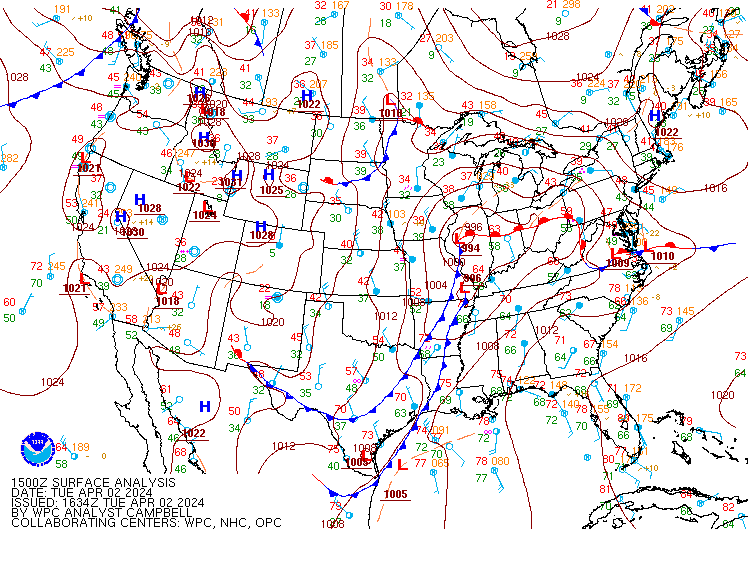
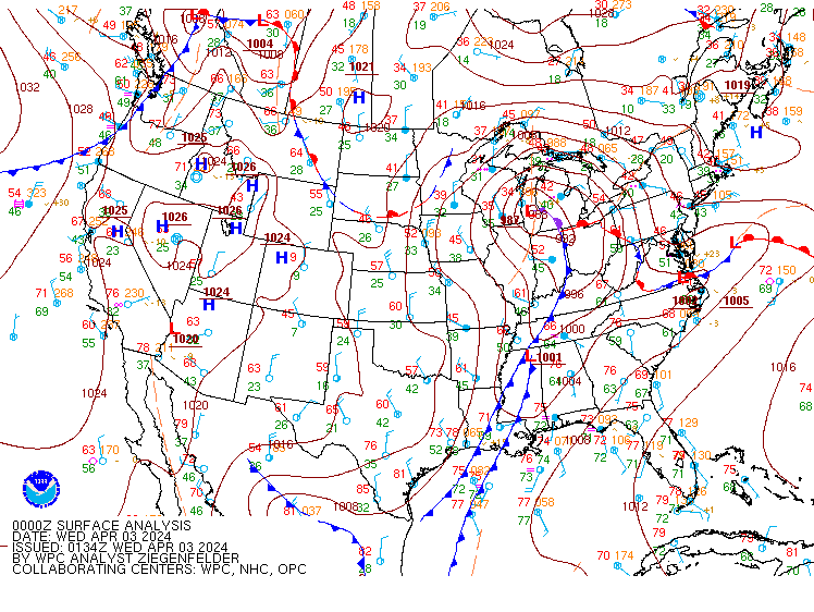
Environment
WPC Analyzed Surface Maps.
 |
 |
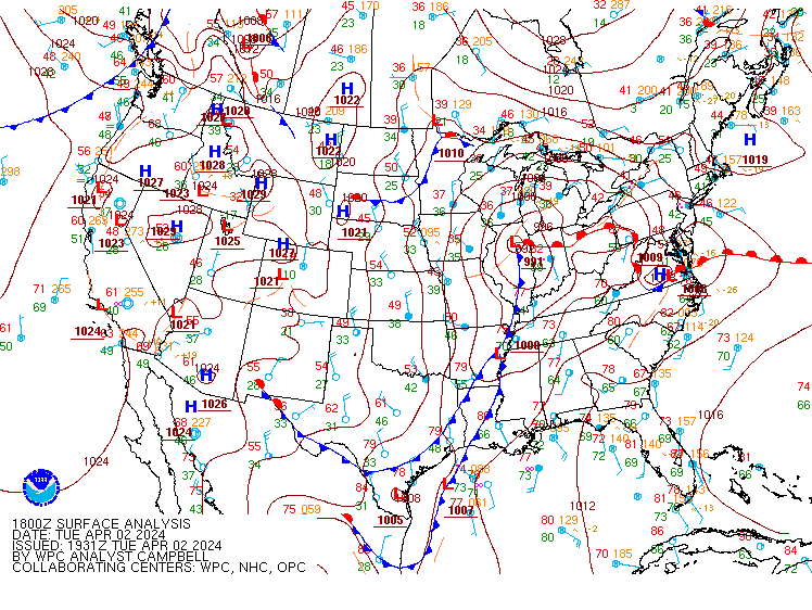 |
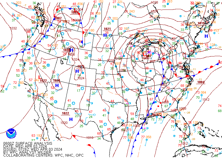
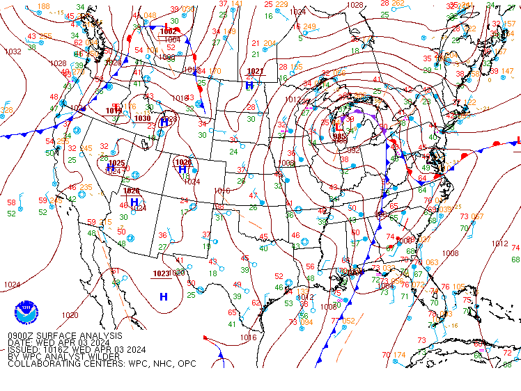
| April 2 12Z | April 2 15Z | April 2 18Z |
 |
 |
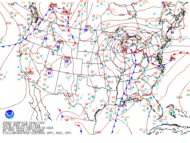 |
| April 2 21Z | April 3 00Z | April 3 03Z |
 |
 |
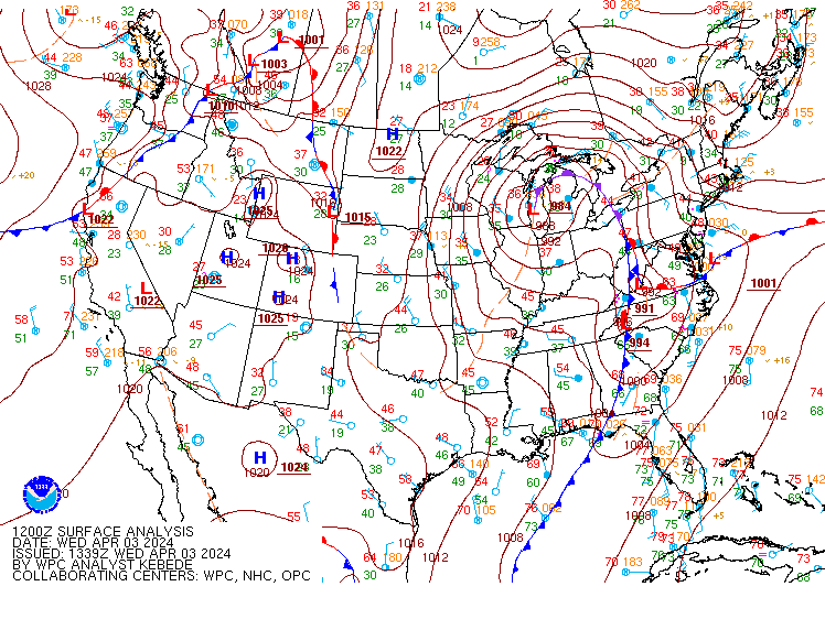 |
| April 3 06Z | April 3 09Z | April 3 12Z |
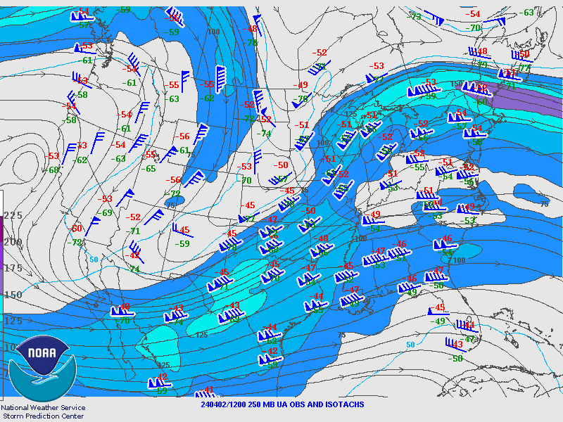
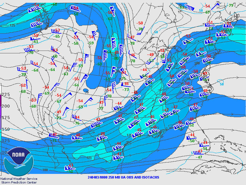
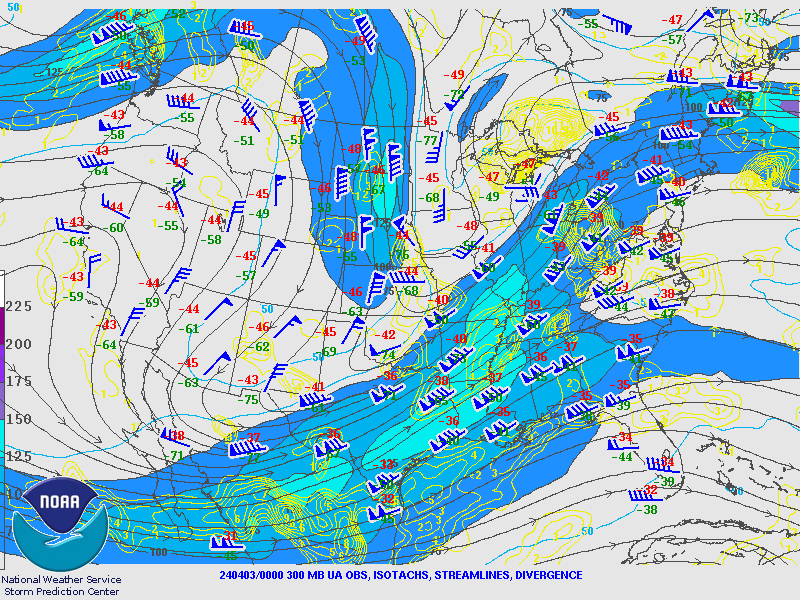
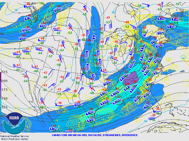
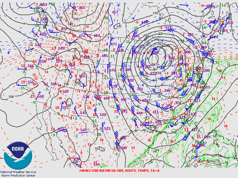
Upper Air Maps from SPC.
April 2nd 12Z Maps
 |
 |
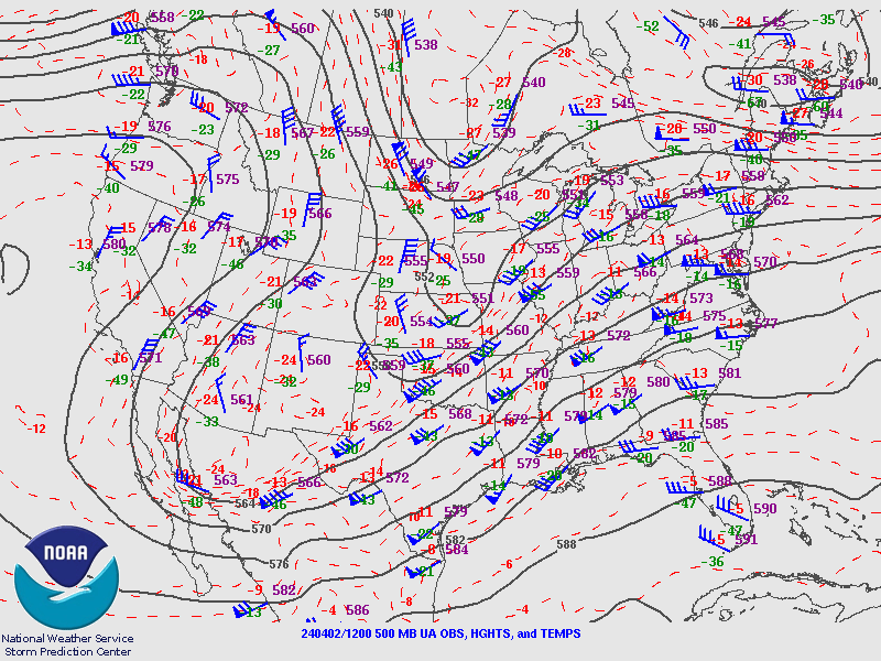 |
| 250MB | 300MB | 500MB |
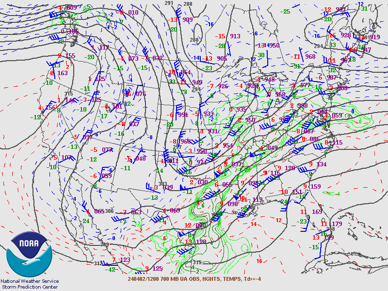 |
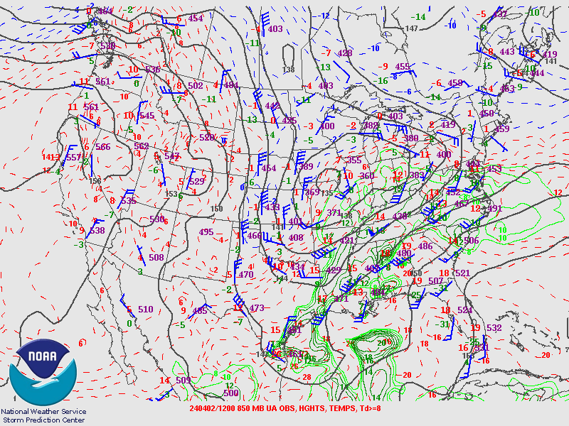 |
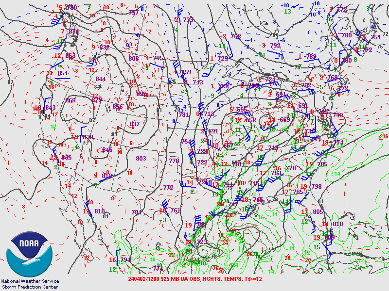 |
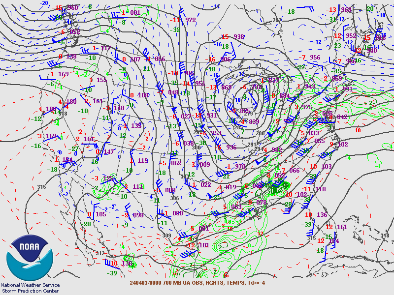
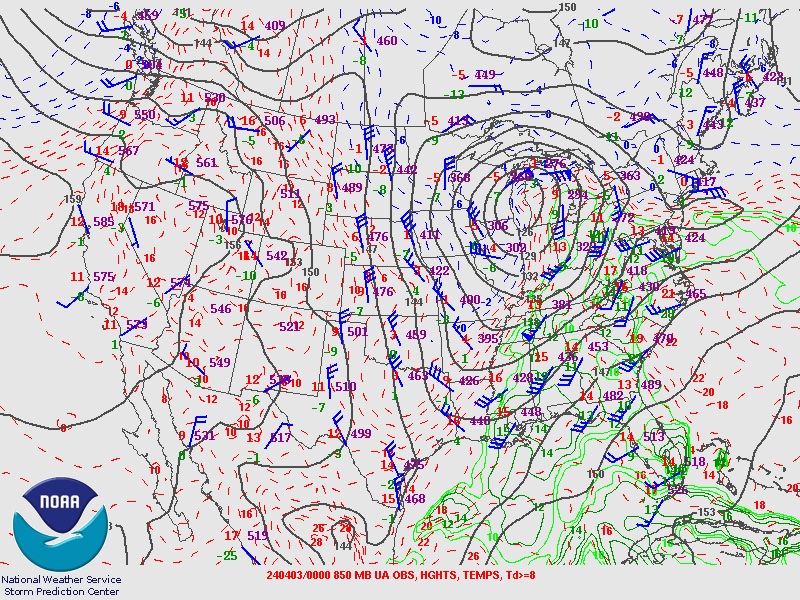
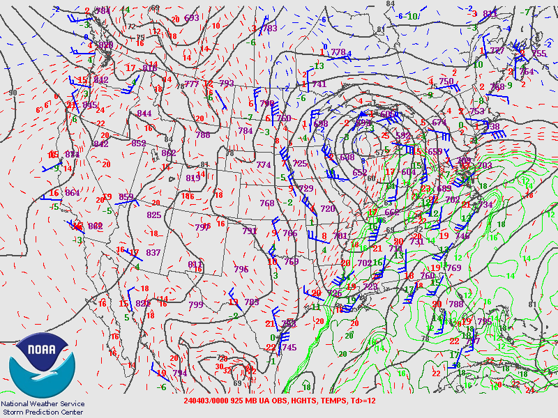
| 700MB | 850MB | 925MB |
April 3rd 00Z Maps
 |
 |
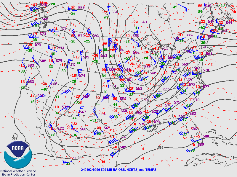 |
| 250MB | 300MB | 500MB |
 |
 |
 |
| 700MB | 850MB | 925MB |
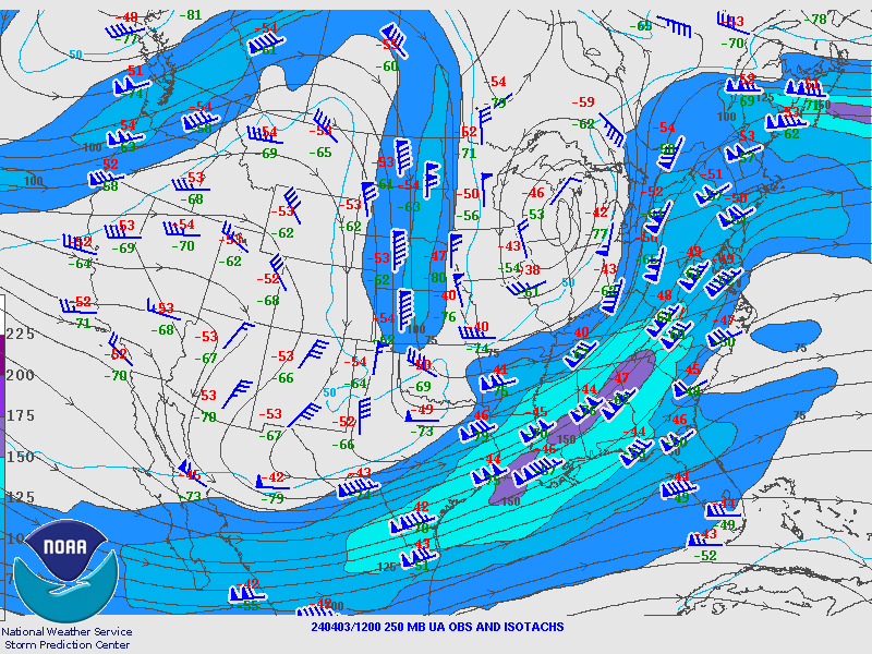
April 3rd 12Z Maps
 |
 |
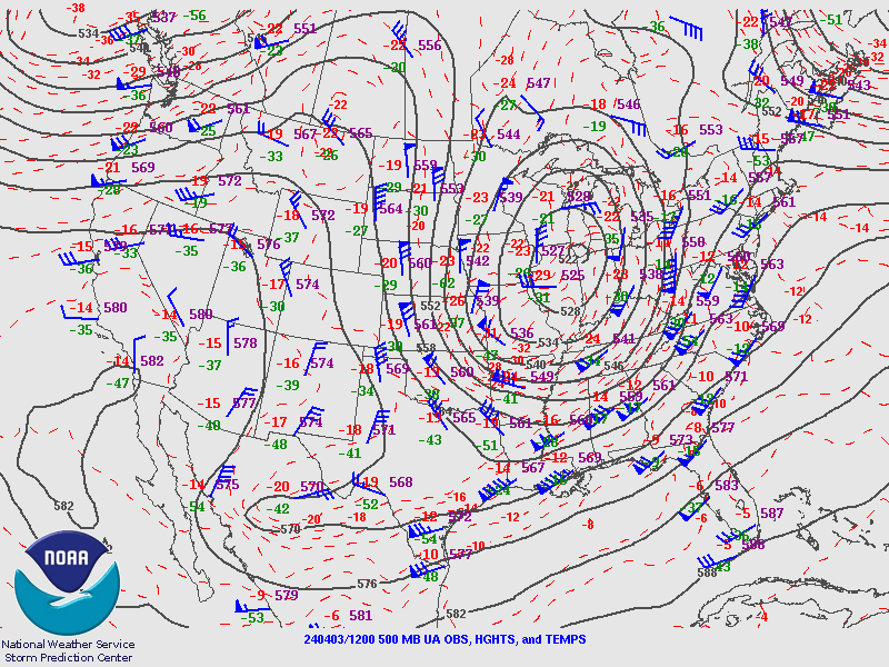 |
| 250MB | 300MB | 500MB |
|
 |
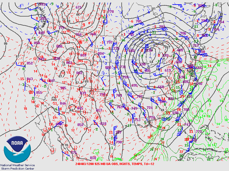 |
| 700MB | 850MB | 925MB |
KPIT Soundings.
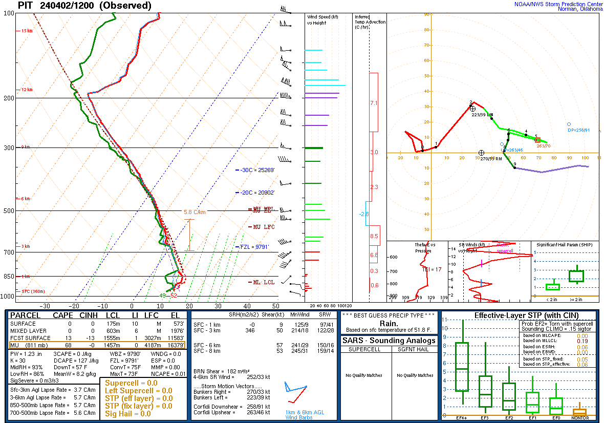 |
.gif) |
.gif) |
| April 2nd 12Z | April 2nd 20Z | April 3rd 00Z |
 |
Media use of NWS Web News Stories is encouraged! Please acknowledge the NWS as the source of any news information accessed from this site. |
|