The 2020 Christmas Arctic Cold Front Event
| During the early morning hours of Christmas Eve, a potent cold front took aim the Ohio Valley and Middle Atlantic Region. Heavy rainfall developed out ahead of the cold front leading to many locations receiving an inch of rain or more. The Arctic Front front began to move into the forecast area in west OH by the afternoon. As the front passed across the forecast area, rain quickly changed over to freezing rain, sleet and then eventually over to snow. Some locations received a significant amount of ice before the change over. Once most locations changed over to snow, temperatures fell rapidly as snowfall intensified, leading to deteriorating road conditions in a short amount of time. This lead to worsening road conditions heading into Christmas Day as lake enhanced snow showers continued through the day on Christmas and into that night. The prolonged event lead to continuous snow covered roads for travelers through the entire holiday. Snowfall amounts ranged from an inch in eastern areas to 11 inches in a few central Ohio locations. NWS Pittsburgh reported a record snowfall of 5.1 inches on Christmas Day. This event pushed snowfall totals into 2nd place for the snowiest December. |  December 25th 2020 National Weather Service Pittsburgh |
Total Event Snowfall Map

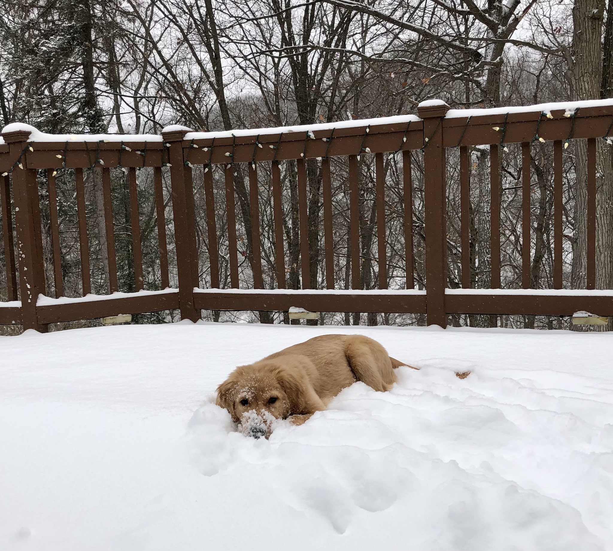
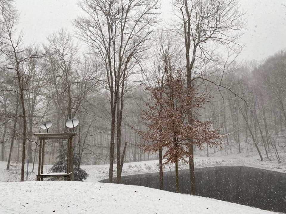
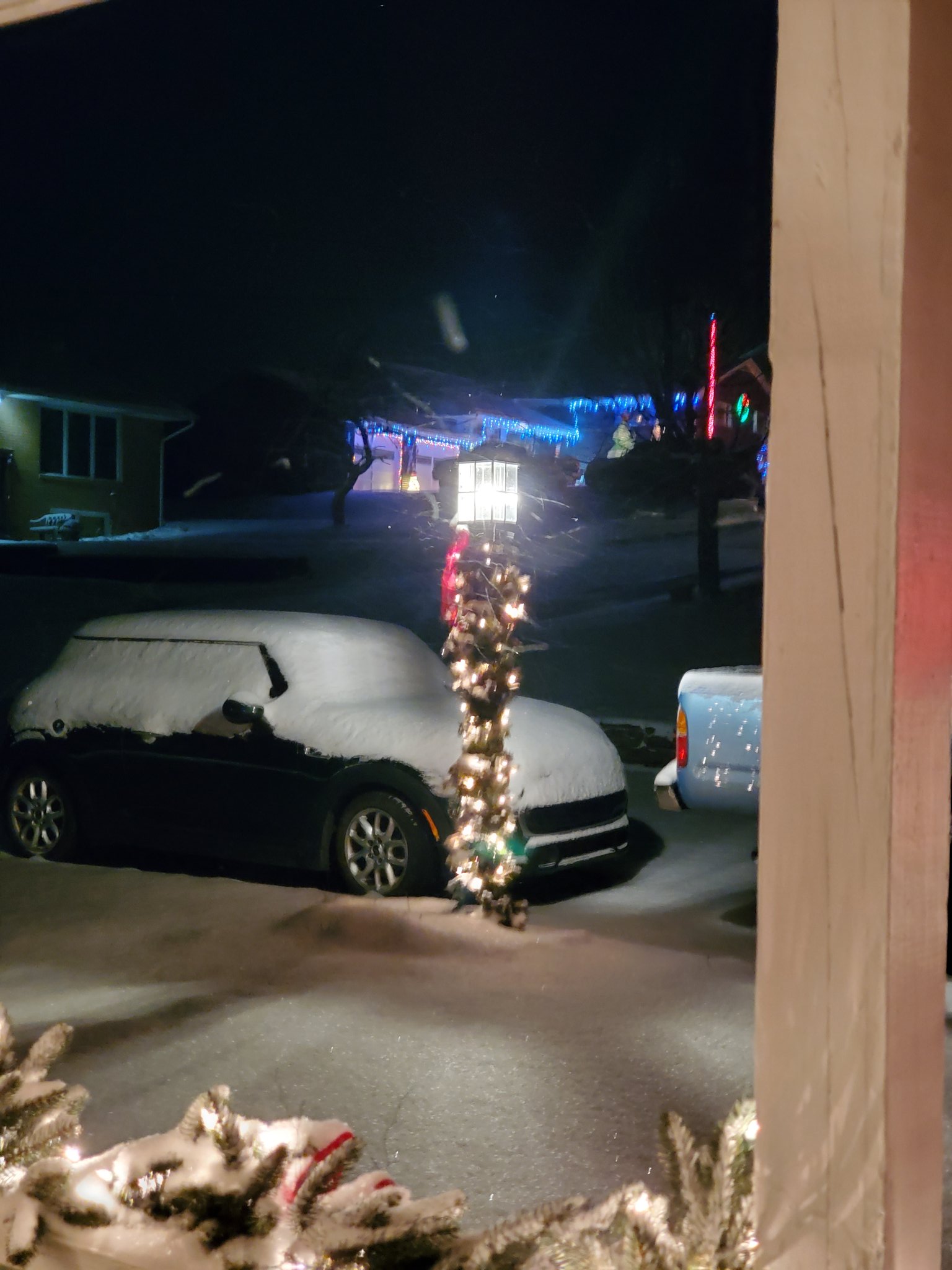
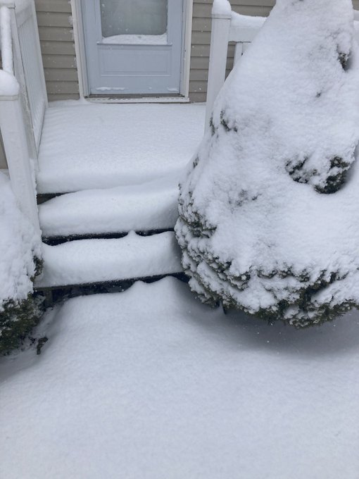
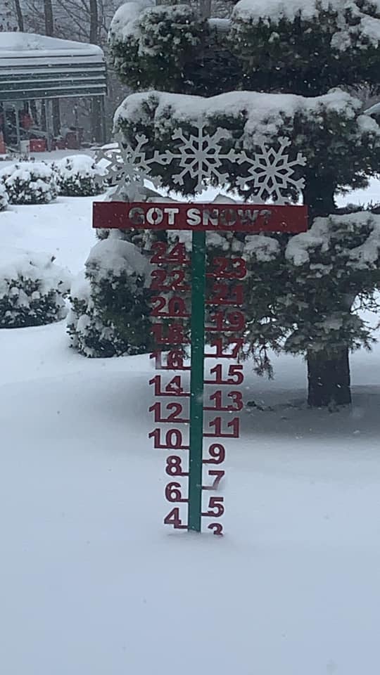
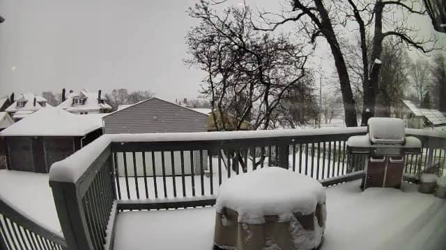
Photos
 |
 |
 |
| Moon Township (Credit: Glen Himes) |
North Central Coshocton County (Credit: Jay Heiser) |
Masontown (Credit: Marcy Roberts) |
 |
 |
 |
Sewickley Township
(Credit: Merry Chrysler)
|
Ross Township
(Credit: Robin Colosimo)
|
Point Breeze North
(Credit: Scot McClellan)
|
Snowfall Reports
PUBLIC INFORMATION STATEMENT
SPOTTER REPORTS
NATIONAL WEATHER SERVICE PITTSBURGH PA
433 PM EST SAT DEC 26 2020

THE FOLLOWING ARE UNOFFICIAL OBSERVATIONS TAKEN DURING THE PAST 36
HOURS FOR THE STORM THAT HAS BEEN AFFECTING OUR REGION. APPRECIATION
IS EXTENDED TO HIGHWAY DEPARTMENTS, COOPERATIVE OBSERVERS, SKYWARN
SPOTTERS AND MEDIA FOR THESE REPORTS. THIS SUMMARY ALSO IS AVAILABLE
ON OUR HOME PAGE AT WEATHER.GOV/PITTSBURGH

********************STORM TOTAL SNOWFALL********************

LOCATION                TOTAL      TIME/DATE  COMMENTS
                     SNOWFALL       MEASURED
                     (INCHES)

OHIO

...BELMONT COUNTY...
  BRIDGEPORT              4.3   735 AM 12/25  TRAINED SPOTTER
  MARTINS FERRY           4.0   811 AM 12/25  FACEBOOK

...CARROLL COUNTY...
  LEESVILLE               6.0   847 AM 12/25  TRAINED SPOTTER
  4 N CARROLLTON          4.5   700 AM 12/25  COCORAHS

...COLUMBIANA COUNTY...
  SALEM                   6.3   700 AM 12/25  PUBLIC
  4 N WELLSVILLE          6.0   900 AM 12/26  COCORAHS
  GLENMOOR                5.5   705 AM 12/25  TWITTER
  3 NW VALLEY             4.5   806 AM 12/25  TRAINED SPOTTER
  ENE HANOVERTON          3.0   400 AM 12/26  COCORAHS

...COSHOCTON COUNTY...
  COSHOCTON               9.0   243 PM 12/25  TOTAL SNOWFALL
  2 NNE FRESNO            7.9   800 AM 12/26  COCORAHS
  NELLIE                  7.0   958 AM 12/25  FACEBOOK
  WEST LAFAYETTE          6.5  1000 AM 12/25  PUBLIC
  TYNDALL                 6.3   900 AM 12/25  PUBLIC
  NEWCASTLE               5.4   800 AM 12/25  PUBLIC

...GUERNSEY COUNTY...
  CAMBRIDGE               5.7   930 AM 12/25  TWITTER
  QUAKER CITY             4.5   700 AM 12/25  PUBLIC

...JEFFERSON COUNTY...
  1 WSW MOUNT PLEASANT    6.2   800 AM 12/26  COCORAHS
  1 WNW WINTERSVILLE      5.5   800 AM 12/25  COCORAHS
  MINGO JUNCTION          5.5   810 AM 12/25  PUBLIC
  1 NE STEUBENVILLE       5.0   700 AM 12/26  CO-OP OBSERVER
  WINTERDALE              4.0   840 AM 12/25  PUBLIC

...MUSKINGUM COUNTY...
  NORTH ZANESVILLE        7.0   820 AM 12/25  PUBLIC
  NASHPORT                6.5  1100 AM 12/25  PUBLIC
  ZANESVILLE              6.5   830 AM 12/25  TWITTER
  STOVERTOWN              6.2  1000 AM 12/25  PUBLIC
  RIX MILLS               4.0   930 AM 12/25  PUBLIC

...TUSCARAWAS COUNTY...
  WNW CARMICHAELS        11.0   700 AM 12/26  COCORAHS
  1 NW DENNISON           7.3   700 AM 12/26  CO-OP OBSERVER
  MINERAL CITY            7.0  1030 AM 12/25  PUBLIC
  ZOAR                    6.5   745 AM 12/25  PUBLIC
  7 SE MINERAL CITY       6.0   800 AM 12/25  COCORAHS
  5 WNW DOVER             6.0   700 AM 12/26  COCORAHS
  1 N UHRICHSVILLE        4.8   700 AM 12/26  COCORAHS
  STONE CREEK             4.5   700 AM 12/25  PUBLIC

PENNSYLVANIA

...ALLEGHENY COUNTY...
  4 NNW PITTSBURGH        7.0   600 AM 12/26  COCORAHS
  2 NE MOON               7.0   730 AM 12/26  CO-OP OBSERVER
  1 SW BRIDGEVILLE        6.7   700 AM 12/26  COCORAHS
  1 NE GIBSONIA           6.5   750 AM 12/26  COCORAHS
  1 S ACMETONIA           5.5   600 AM 12/26  CO-OP OBSERVER
  1 N CARNOT-MOON         5.4   107 PM 12/25  24 HOUR SNOWFALL TOTAL.
  2 SE SOUTH FAYETTE      5.2   700 AM 12/26  COCORAHS
  2 S MCCANDLESS TOWNS    5.1   700 AM 12/26  COCORAHS
  BRADDOCK LOCK AND DA    5.0   600 AM 12/26  CO-OP OBSERVER
  8 ENE PITTSBURGH        4.5   800 AM 12/26  COCORAHS
  CARRICK                 4.3  1000 AM 12/25  PUBLIC
  IMPERIAL                4.2   730 AM 12/25  TWITTER
  CASTLE SHANNON          4.0   826 AM 12/25  TWITTER
  BEN AVON                4.0   600 AM 12/26  HADS
  SCOTT TOWNSHIP          4.0   820 AM 12/25  FACEBOOK
  6 E PITTSBURGH          3.9   900 AM 12/25  COCORAHS
  SHADYSIDE               3.8   800 AM 12/25  FACEBOOK
  OAKDALE                 3.5   725 AM 12/25  PUBLIC
  HARWICK                 3.5   815 AM 12/25  TWITTER
  GLENSHAW                3.1   700 AM 12/25  PUBLIC
  MCCANDLESS TOWNSHIP     3.1   745 AM 12/25  TRAINED SPOTTER
  BRENTWOOD               3.0   848 AM 12/25  TWITTER
  NW ASPINWALL            3.0   700 AM 12/26  COCORAHS
  2 S PENN HILLS          2.8   730 AM 12/25  TRAINED SPOTTER
  CURTISVILLE             2.5   705 AM 12/25  FACEBOOK
  JEFFERSON HILLS         2.5   800 AM 12/25  TRAINED SPOTTER

...ARMSTRONG COUNTY...
  1 SSW KITTANNING        3.8   700 AM 12/26  COCORAHS
  4 NW DAYTON             3.5   700 AM 12/26  CO-OP OBSERVER
  4 S LENAPE HEIGHTS      3.5   700 AM 12/26  CO-OP OBSERVER
  6 N VANDERGRIFT         3.3   700 AM 12/26  COCORAHS
  3 NNW SHELOCTA          2.9   700 AM 12/26  COCORAHS
  SCHENLEY                2.0   700 AM 12/26  CO-OP OBSERVER
  CADOGAN                 1.8   900 AM 12/25  PUBLIC

...BEAVER COUNTY...
  MONTGOMERY DAM          8.0   600 AM 12/25  CO-OP OBSERVER
  3 NE NEW BRIGHTON       6.4   800 AM 12/26  COCORAHS
  3 NNW NEW SHEFFIELD     6.0  1016 AM 12/25  NWS EMPLOYEE
  MONACA                  5.5   903 AM 12/25  TRAINED SPOTTER
  ALIQUIPPA               5.2  1100 AM 12/25  PUBLIC
  6 W BEAVER              5.0   700 AM 12/26  COCORAHS
  ECONOMY                 4.8   958 AM 12/25  TWITTER
  1 S DAVIDSON HEIGHTS    4.3   715 AM 12/25  TWITTER

...BUTLER COUNTY...
  2 W BUTLER              8.1   830 AM 12/26  COCORAHS
  2 NNE FOX RUN           7.0   600 AM 12/26  COCORAHS
  N CABOT                 5.0   700 AM 12/26  COCORAHS
  1 WNW FERNWAY           4.5   920 AM 12/25  PUBLIC
  2 WSW BUTLER            4.5   700 AM 12/25  COCORAHS
  1 E VALENCIA            4.5   910 AM 12/25  COCORAHS
  2 NE SARVER             4.1   737 AM 12/26  COCORAHS
  ZELIENOPLE              4.0  1000 AM 12/25  PUBLIC
  PROSPECT                3.8   745 AM 12/25  PUBLIC
  EAST BUTLER             3.5   700 AM 12/25  PUBLIC
  2 WNW CABOT             3.5   700 AM 12/26  COCORAHS
  MARS                    3.5   800 AM 12/25  PUBLIC
  BUTLER                  3.0   800 AM 12/25  FACEBOOK
  7 SW BUTLER             3.0   600 AM 12/25  COCORAHS
  1 SSE BUTLER            3.0   700 AM 12/25  FACEBOOK
  NORTH WASHINGTON        3.0   900 AM 12/25  PUBLIC
  WEST SUNBURY            2.5   825 AM 12/25  TWITTER
  1 S HARRISVILLE         2.2   700 AM 12/26  COCORAHS

...CLARION COUNTY...
  4 WNW SUMMERVILLE       3.8   820 AM 12/26  COCORAHS
  NEW BETHLEHEM           2.9   730 AM 12/25  FACEBOOK
  STRATTANVILLE           2.0   700 AM 12/25  PUBLIC
  CLARION                 2.0   820 AM 12/25  TRAINED SPOTTER
  COOKSBURG               1.4   930 AM 12/25  PUBLIC

...FAYETTE COUNTY...
  1 SE POINT MARION       4.1   700 AM 12/26  COCORAHS
  OHIOPYLE                3.8   830 AM 12/25  PUBLIC
  JUNIATA                 3.6  1100 AM 12/25  PUBLIC
  PERRYOPOLIS             3.0   848 AM 12/25  TRAINED SPOTTER
  MASONTOWN               3.0   709 AM 12/25  TWITTER
  2 NNE UNIONTOWN         2.5   544 PM 12/25  COCORAHS
  1 SW SOUTH CONNELLSV    2.0   500 AM 12/26  CO-OP OBSERVER

...FOREST COUNTY...
  7 SSE TIONESTA          6.7   700 AM 12/26  COCORAHS
  5 W MARIENVILLE         4.1   620 AM 12/26  COCORAHS

...GREENE COUNTY...
  1 E WAYNESBURG          6.2   700 AM 12/26  CO-OP OBSERVER
  DRY TAVERN              4.8   750 AM 12/25  PUBLIC
  WNW CARMICHAELS         4.0   800 AM 12/25  COCORAHS
  1 SW POINT MARION       3.2   600 AM 12/25  CO-OP OBSERVER

...INDIANA COUNTY...
  7 WNW INDIANA           1.9   800 AM 12/25  COCORAHS
  PIKES PEAK              1.2   550 AM 12/25  PUBLIC
  3 SE INDIANA            1.0   700 AM 12/25  CO-OP OBSERVER

...JEFFERSON COUNTY...
  S TIMBLIN               4.2   720 AM 12/26  COCORAHS

...LAWRENCE COUNTY...
  VOLANT                  5.3   930 AM 12/25  PUBLIC
  SOUTH NEW CASTLE        4.2   740 AM 12/25  PUBLIC
  ENON VALLEY             3.3   800 AM 12/25  PUBLIC

...MERCER COUNTY...
  2 SW HERMITAGE          7.0   915 AM 12/25  COCORAHS
  FREDONIA                6.1   800 AM 12/25  PUBLIC
  2 S WEST MIDDLESEX      5.7   915 AM 12/26  COCORAHS
  SHARPSVILLE             5.5   645 AM 12/25  PUBLIC
  SHARON                  4.7   900 AM 12/25  PUBLIC

...VENANGO COUNTY...
  6 SW TITUSVILLE         5.9   700 AM 12/26  COCORAHS
  1 SSW FRANKLIN          5.5   600 AM 12/26  COCORAHS
  1 E COOPERSTOWN         5.2   700 AM 12/26  COCORAHS
  POLK                    3.0   930 AM 12/25  FACEBOOK
  1 NNE SENECA            3.0   700 AM 12/25  COCORAHS
  1 E FRANKLIN            2.5   805 AM 12/25  CO-OP OBSERVER

...WASHINGTON COUNTY...
  1 W CANONSBURG          5.5   700 AM 12/26  COCORAHS
  WASHINGTON              5.2   900 AM 12/25  TWITTER
  MCMURRAY                4.7   700 AM 12/26  COCORAHS
  CHARLEROI               4.5   900 AM 12/25  TWITTER
  1 NNW FINLEYVILLE       4.0   700 AM 12/26  COCORAHS
  4 NW CANONSBURG         3.6   700 AM 12/26  COCORAHS
  SSE DUNLEVY             3.4   800 AM 12/25  COCORAHS
  MCDONALD                3.4   700 AM 12/25  PUBLIC
  FINLEYVILLE             3.0   658 AM 12/25  PUBLIC
  WNW BULGER              2.1   700 AM 12/25  COCORAHS

...WESTMORELAND COUNTY...
  NNE ADAMSBURG           6.2   630 PM 12/25  COCORAHS
  SE LIGONIER             5.5   700 AM 12/26  COCORAHS
  1 SW LEECHBURG          5.0   800 AM 12/26  COCORAHS
  ESE NEW FLORENCE        4.3   915 AM 12/26  COCORAHS
  1 SW NEW STANTON        4.0   700 AM 12/26  CO-OP OBSERVER
  2 NW DONEGAL            4.0   700 AM 12/25  CO-OP OBSERVER
  3 E NORTH WASHINGTON    3.6   700 AM 12/26  CO-OP OBSERVER
  W IRWIN                 3.5   600 PM 12/25  COCORAHS
  1 E LIGONIER            3.5   700 AM 12/26  COCORAHS
  1 WNW LOWER BURRELL     3.5   800 AM 12/25  COCORAHS
  LIGONIER                3.3   930 AM 12/25  TRAINED SPOTTER
  4 E NEW KENSINGTON      3.0   800 AM 12/25  COCORAHS
  ADAMSBURG               2.9  1100 AM 12/25  PUBLIC

WEST VIRGINIA

...BROOKE COUNTY...
  1 N WELLSBURG           6.0  1243 PM 12/25  DEPT OF HIGHWAYS

...HANCOCK COUNTY...
  2 E STRATTON            6.5  1244 PM 12/25  DEPT OF HIGHWAYS
  WEIRTON HEIGHTS         5.0   830 AM 12/25  TRAINED SPOTTER

...MARION COUNTY...
  2 N RIVESVILLE          6.0   600 AM 12/26  COCORAHS
  FAIRMONT                4.0  1030 AM 12/25  PUBLIC

...MARSHALL COUNTY...
  GLEN DALE               5.0   245 PM 12/25  DEPT OF HIGHWAYS

...MONONGALIA COUNTY...
  6 SW MORGANTOWN         7.1   700 AM 12/26  COCORAHS
  COOPERS ROCK            7.0   504 PM 12/25  BROADCAST MEDIA
  LAUREL POINT            4.3   830 AM 12/25  PUBLIC
  5 SW MORGANTOWN         4.3   815 AM 12/25  TWITTER
  1 NNW RIDGEDALE         2.5   630 AM 12/25  FACEBOOK

...OHIO COUNTY...
  4 NNE VALLEY GROVE      7.5   700 AM 12/26  COCORAHS
  WHEELING                5.5   956 AM 12/25  FACEBOOK
  TRIADELPHIA             5.0   246 PM 12/25  DEPT OF HIGHWAYS

...PRESTON COUNTY...
  5 NNE TERRA ALTA        7.6   800 AM 12/26  COCORAHS
  3 ENE TERRA ALTA        6.5   700 AM 12/26  COCORAHS
  INDEPENDENCE            5.5  1225 PM 12/25  PUBLIC
  GLADESVILLE             4.7   940 AM 12/25  FACEBOOK
  7 N THOMAS              2.5   700 AM 12/26  COCORAHS
  1 E KINGWOOD            1.6   700 AM 12/25  COCORAHS

...TUCKER COUNTY...
  THOMAS                  7.0   504 PM 12/25  BROADCAST MEDIA
  DAVIS                   5.2   700 AM 12/26  CO-OP OBSERVER
  3 S CANAAN HGTS         4.4   900 AM 12/26  CO-OP OBSERVER

...WETZEL COUNTY...
  7 E NEW MARTINSVILLE    6.5   800 AM 12/26  COCORAHS
  1 N NEW MARTINSVILLE    4.0   246 PM 12/25  DEPT OF HIGHWAYS
  2 N GLOVER GAP          3.0   725 AM 12/26  CO-OP OBSERVER

&&

*****METADATA*****
:12/25/2020,  735 AM, OH, BELMONT, BRIDGEPORT, , , 40.0665, -80.7468, SNOW, 4.3, INCH, TRAINED SPOTTER, STORM TOTAL SNOW,
:12/25/2020,  811 AM, OH, BELMONT, MARTINS FERRY, , , 40.1013, -80.7239, SNOW, 4.0, INCH, FACEBOOK, STORM TOTAL SNOW,
:12/25/2020,  847 AM, OH, CARROLL, LEESVILLE, , , 40.4509, -81.2096, SNOW, 6.0, INCH, TRAINED SPOTTER, STORM TOTAL SNOW,
:12/25/2020,  700 AM, OH, CARROLL, CARROLLTON, 4, N, 40.6356, -81.0879, SNOW, 4.5, INCH, COCORAHS, STORM TOTAL SNOW,
:12/25/2020,  700 AM, OH, COLUMBIANA, SALEM, , , 40.9026, -80.8537, SNOW, 6.3, INCH, PUBLIC, STORM TOTAL SNOW,
:12/26/2020,  900 AM, OH, COLUMBIANA, WELLSVILLE, 4, N, 40.6644, -80.6424, SNOW, 6.0, INCH, COCORAHS, STORM TOTAL SNOW,
:12/25/2020,  705 AM, OH, COLUMBIANA, GLENMOOR, , , 40.6651, -80.6132, SNOW, 5.5, INCH, TWITTER, STORM TOTAL SNOW,
:12/25/2020,  806 AM, OH, COLUMBIANA, VALLEY, 3, NW, 40.9007, -80.9943, SNOW, 4.5, INCH, TRAINED SPOTTER, STORM TOTAL SNOW,
:12/26/2020,  400 AM, OH, COLUMBIANA, HANOVERTON, , ENE, 40.7570, -80.9292, SNOW, 3.0, INCH, COCORAHS, STORM TOTAL SNOW,
:12/25/2020,  243 PM, OH, COSHOCTON, COSHOCTON, , , 40.2637, -81.8496, SNOW, 9.0, INCH, TRAINED SPOTTER, STORM TOTAL SNOW, TOTAL SNOWFALL
:12/26/2020,  800 AM, OH, COSHOCTON, FRESNO, 2, NNE, 40.3583, -81.7193, SNOW, 7.9, INCH, COCORAHS, STORM TOTAL SNOW,
:12/25/2020,  958 AM, OH, COSHOCTON, NELLIE, , , 40.3383, -82.0684, SNOW, 7.0, INCH, FACEBOOK, STORM TOTAL SNOW,
:12/25/2020, 1000 AM, OH, COSHOCTON, WEST LAFAYETTE, , , 40.2739, -81.7510, SNOW, 6.5, INCH, PUBLIC, STORM TOTAL SNOW,
:12/25/2020,  900 AM, OH, COSHOCTON, TYNDALL, , , 40.2173, -81.8821, SNOW, 6.3, INCH, PUBLIC, STORM TOTAL SNOW,
:12/25/2020,  800 AM, OH, COSHOCTON, NEWCASTLE, , , 40.3351, -82.1657, SNOW, 5.4, INCH, PUBLIC, STORM TOTAL SNOW,
:12/25/2020,  930 AM, OH, GUERNSEY, CAMBRIDGE, , , 40.0250, -81.5869, SNOW, 5.7, INCH, TWITTER, STORM TOTAL SNOW,
:12/25/2020,  700 AM, OH, GUERNSEY, QUAKER CITY, , , 39.9691, -81.2964, SNOW, 4.5, INCH, PUBLIC, STORM TOTAL SNOW,
:12/26/2020,  800 AM, OH, JEFFERSON, MOUNT PLEASANT, 1, WSW, 40.1650, -80.8229, SNOW, 6.2, INCH, COCORAHS, STORM TOTAL SNOW,
:12/25/2020,  800 AM, OH, JEFFERSON, WINTERSVILLE, 1, WNW, 40.3843, -80.7176, SNOW, 5.5, INCH, COCORAHS, STORM TOTAL SNOW,
:12/25/2020,  810 AM, OH, JEFFERSON, MINGO JUNCTION, , , 40.3206, -80.6136, SNOW, 5.5, INCH, PUBLIC, STORM TOTAL SNOW,
:12/26/2020,  700 AM, OH, JEFFERSON, STEUBENVILLE, 1, NE, 40.3764, -80.6281, SNOW, 5.0, INCH, CO-OP OBSERVER, STORM TOTAL SNOW,
:12/25/2020,  840 AM, OH, JEFFERSON, WINTERDALE, , , 40.3701, -80.7087, SNOW, 4.0, INCH, PUBLIC, STORM TOTAL SNOW,
:12/25/2020,  820 AM, OH, MUSKINGUM, NORTH ZANESVILLE, , , 39.9822, -82.0001, SNOW, 7.0, INCH, PUBLIC, STORM TOTAL SNOW,
:12/25/2020, 1100 AM, OH, MUSKINGUM, NASHPORT, , , 40.0706, -82.1757, SNOW, 6.5, INCH, PUBLIC, STORM TOTAL SNOW,
:12/25/2020,  830 AM, OH, MUSKINGUM, ZANESVILLE, , , 39.9524, -82.0120, SNOW, 6.5, INCH, TWITTER, STORM TOTAL SNOW,
:12/25/2020, 1000 AM, OH, MUSKINGUM, STOVERTOWN, , , 39.8415, -81.9868, SNOW, 6.2, INCH, PUBLIC, STORM TOTAL SNOW,
:12/25/2020,  930 AM, OH, MUSKINGUM, RIX MILLS, , , 39.9242, -81.7462, SNOW, 4.0, INCH, PUBLIC, STORM TOTAL SNOW,
:12/26/2020,  700 AM, OH, TUSCARAWAS, CARMICHAELS, , WNW, 40.5114, -81.6257, SNOW, 11.0, INCH, COCORAHS, STORM TOTAL SNOW,
:12/26/2020,  700 AM, OH, TUSCARAWAS, DENNISON, 1, NW, 40.4056, -81.3431, SNOW, 7.3, INCH, CO-OP OBSERVER, STORM TOTAL SNOW,
:12/25/2020, 1030 AM, OH, TUSCARAWAS, MINERAL CITY, , , 40.6024, -81.3615, SNOW, 7.0, INCH, PUBLIC, STORM TOTAL SNOW,
:12/25/2020,  745 AM, OH, TUSCARAWAS, ZOAR, , , 40.6140, -81.4243, SNOW, 6.5, INCH, PUBLIC, STORM TOTAL SNOW,
:12/25/2020,  800 AM, OH, TUSCARAWAS, MINERAL CITY, 7, SE, 40.5205, -81.2769, SNOW, 6.0, INCH, COCORAHS, STORM TOTAL SNOW,
:12/26/2020,  700 AM, OH, TUSCARAWAS, DOVER, 5, WNW, 40.5507, -81.5640, SNOW, 6.0, INCH, COCORAHS, STORM TOTAL SNOW,
:12/26/2020,  700 AM, OH, TUSCARAWAS, UHRICHSVILLE, 1, N, 40.4099, -81.3532, SNOW, 4.8, INCH, COCORAHS, STORM TOTAL SNOW,
:12/25/2020,  700 AM, OH, TUSCARAWAS, STONE CREEK, , , 40.3987, -81.5587, SNOW, 4.5, INCH, PUBLIC, STORM TOTAL SNOW,
:12/26/2020,  600 AM, PA, ALLEGHENY, PITTSBURGH, 4, NNW, 40.4888, -80.0006, SNOW, 7.0, INCH, COCORAHS, STORM TOTAL SNOW,
:12/26/2020,  730 AM, PA, ALLEGHENY, MOON, 2, NE, 40.5319, -80.2172, SNOW, 7.0, INCH, CO-OP OBSERVER, STORM TOTAL SNOW,
:12/26/2020,  700 AM, PA, ALLEGHENY, BRIDGEVILLE, 1, SW, 40.3417, -80.1229, SNOW, 6.7, INCH, COCORAHS, STORM TOTAL SNOW,
:12/26/2020,  750 AM, PA, ALLEGHENY, GIBSONIA, 1, NE, 40.6405, -79.9506, SNOW, 6.5, INCH, COCORAHS, STORM TOTAL SNOW,
:12/26/2020,  600 AM, PA, ALLEGHENY, ACMETONIA, 1, S, 40.5361, -79.8153, SNOW, 5.5, INCH, CO-OP OBSERVER, STORM TOTAL SNOW,
:12/25/2020,  107 PM, PA, ALLEGHENY, CARNOT-MOON, 1, N, 40.5319, -80.2174, SNOW, 5.4, INCH, OFFICIAL NWS OBS, STORM TOTAL SNOW, 24 HOUR SNOWFALL TOTAL.
:12/26/2020,  700 AM, PA, ALLEGHENY, SOUTH FAYETTE, 2, SE, 40.3381, -80.1159, SNOW, 5.2, INCH, COCORAHS, STORM TOTAL SNOW,
:12/26/2020,  700 AM, PA, ALLEGHENY, MCCANDLESS TOWNSHIP, 2, S, 40.5569, -80.0366, SNOW, 5.1, INCH, COCORAHS, STORM TOTAL SNOW,
:12/26/2020,  600 AM, PA, ALLEGHENY, BRADDOCK LOCK AND DAM, , , 40.3917, -79.8594, SNOW, 5.0, INCH, CO-OP OBSERVER, STORM TOTAL SNOW,
:12/26/2020,  800 AM, PA, ALLEGHENY, PITTSBURGH, 8, ENE, 40.4993, -79.8533, SNOW, 4.5, INCH, COCORAHS, STORM TOTAL SNOW,
:12/25/2020, 1000 AM, PA, ALLEGHENY, CARRICK, , , 40.3965, -79.9903, SNOW, 4.3, INCH, PUBLIC, STORM TOTAL SNOW,
:12/25/2020,  730 AM, PA, ALLEGHENY, IMPERIAL, , , 40.4495, -80.2445, SNOW, 4.2, INCH, TWITTER, STORM TOTAL SNOW,
:12/25/2020,  826 AM, PA, ALLEGHENY, CASTLE SHANNON, , , 40.3663, -80.0202, SNOW, 4.0, INCH, TWITTER, STORM TOTAL SNOW,
:12/26/2020,  600 AM, PA, ALLEGHENY, BEN AVON, , , 40.5053, -80.0897, SNOW, 4.0, INCH, HADS, STORM TOTAL SNOW,
:12/25/2020,  820 AM, PA, ALLEGHENY, SCOTT TOWNSHIP, , , 40.3862, -80.0772, SNOW, 4.0, INCH, FACEBOOK, STORM TOTAL SNOW,
:12/25/2020,  900 AM, PA, ALLEGHENY, PITTSBURGH, 6, E, 40.4318, -79.8925, SNOW, 3.9, INCH, COCORAHS, STORM TOTAL SNOW,
:12/25/2020,  800 AM, PA, ALLEGHENY, SHADYSIDE, , , 40.4515, -79.9409, SNOW, 3.8, INCH, FACEBOOK, STORM TOTAL SNOW,
:12/25/2020,  725 AM, PA, ALLEGHENY, OAKDALE, , , 40.3997, -80.1877, SNOW, 3.5, INCH, PUBLIC, STORM TOTAL SNOW,
:12/25/2020,  815 AM, PA, ALLEGHENY, HARWICK, , , 40.5567, -79.8050, SNOW, 3.5, INCH, TWITTER, STORM TOTAL SNOW,
:12/25/2020,  700 AM, PA, ALLEGHENY, GLENSHAW, , , 40.5328, -79.9676, SNOW, 3.1, INCH, PUBLIC, STORM TOTAL SNOW,
:12/25/2020,  745 AM, PA, ALLEGHENY, MCCANDLESS TOWNSHIP, , , 40.5835, -80.0300, SNOW, 3.1, INCH, TRAINED SPOTTER, STORM TOTAL SNOW,
:12/25/2020,  848 AM, PA, ALLEGHENY, BRENTWOOD, , , 40.3733, -79.9760, SNOW, 3.0, INCH, TWITTER, STORM TOTAL SNOW,
:12/26/2020,  700 AM, PA, ALLEGHENY, ASPINWALL, , NW, 40.4928, -79.9043, SNOW, 3.0, INCH, COCORAHS, STORM TOTAL SNOW,
:12/25/2020,  730 AM, PA, ALLEGHENY, PENN HILLS, 2, S, 40.4498, -79.8270, SNOW, 2.8, INCH, TRAINED SPOTTER, STORM TOTAL SNOW,
:12/25/2020,  705 AM, PA, ALLEGHENY, CURTISVILLE, , , 40.6487, -79.8496, SNOW, 2.5, INCH, FACEBOOK, STORM TOTAL SNOW,
:12/25/2020,  800 AM, PA, ALLEGHENY, JEFFERSON HILLS, , , 40.2912, -79.9320, SNOW, 2.5, INCH, TRAINED SPOTTER, STORM TOTAL SNOW,
:12/26/2020,  700 AM, PA, ARMSTRONG, KITTANNING, 1, SSW, 40.8095, -79.5306, SNOW, 3.8, INCH, COCORAHS, STORM TOTAL SNOW,
:12/26/2020,  700 AM, PA, ARMSTRONG, DAYTON, 4, NW, 40.9250, -79.2825, SNOW, 3.5, INCH, CO-OP OBSERVER, STORM TOTAL SNOW,
:12/26/2020,  700 AM, PA, ARMSTRONG, LENAPE HEIGHTS, 4, S, 40.7136, -79.5150, SNOW, 3.5, INCH, CO-OP OBSERVER, STORM TOTAL SNOW,
:12/26/2020,  700 AM, PA, ARMSTRONG, VANDERGRIFT, 6, N, 40.6847, -79.5936, SNOW, 3.3, INCH, COCORAHS, STORM TOTAL SNOW,
:12/26/2020,  700 AM, PA, ARMSTRONG, SHELOCTA, 3, NNW, 40.6981, -79.3228, SNOW, 2.9, INCH, COCORAHS, STORM TOTAL SNOW,
:12/26/2020,  700 AM, PA, ARMSTRONG, SCHENLEY, , , 40.6842, -79.6681, SNOW, 2.0, INCH, CO-OP OBSERVER, STORM TOTAL SNOW,
:12/25/2020,  900 AM, PA, ARMSTRONG, CADOGAN, , , 40.7540, -79.5812, SNOW, 1.8, INCH, PUBLIC, STORM TOTAL SNOW,
:12/25/2020,  600 AM, PA, BEAVER, MONTGOMERY DAM, , , 40.6483, -80.3850, SNOW, 8.0, INCH, CO-OP OBSERVER, STORM TOTAL SNOW,
:12/26/2020,  800 AM, PA, BEAVER, NEW BRIGHTON, 3, NE, 40.7694, -80.2729, SNOW, 6.4, INCH, COCORAHS, STORM TOTAL SNOW,
:12/25/2020, 1016 AM, PA, BEAVER, NEW SHEFFIELD, 3, NNW, 40.6324, -80.3006, SNOW, 6.0, INCH, NWS EMPLOYEE, STORM TOTAL SNOW,
:12/25/2020,  903 AM, PA, BEAVER, MONACA, , , 40.6833, -80.2732, SNOW, 5.5, INCH, TRAINED SPOTTER, STORM TOTAL SNOW,
:12/25/2020, 1100 AM, PA, BEAVER, ALIQUIPPA, , , 40.6174, -80.2550, SNOW, 5.2, INCH, PUBLIC, STORM TOTAL SNOW,
:12/26/2020,  700 AM, PA, BEAVER, BEAVER, 6, W, 40.7050, -80.4121, SNOW, 5.0, INCH, COCORAHS, STORM TOTAL SNOW,
:12/25/2020,  958 AM, PA, BEAVER, ECONOMY, , , 40.6384, -80.1851, SNOW, 4.8, INCH, TWITTER, STORM TOTAL SNOW,
:12/25/2020,  715 AM, PA, BEAVER, DAVIDSON HEIGHTS, 1, S, 40.5760, -80.2599, SNOW, 4.3, INCH, TWITTER, STORM TOTAL SNOW,
:12/26/2020,  830 AM, PA, BUTLER, BUTLER, 2, W, 40.8640, -79.9260, SNOW, 8.1, INCH, COCORAHS, STORM TOTAL SNOW,
:12/26/2020,  600 AM, PA, BUTLER, FOX RUN, 2, NNE, 40.7239, -80.0706, SNOW, 7.0, INCH, COCORAHS, STORM TOTAL SNOW,
:12/26/2020,  700 AM, PA, BUTLER, CABOT, , N, 40.7687, -79.7669, SNOW, 5.0, INCH, COCORAHS, STORM TOTAL SNOW,
:12/25/2020,  920 AM, PA, BUTLER, FERNWAY, 1, WNW, 40.7000, -80.1440, SNOW, 4.5, INCH, PUBLIC, STORM TOTAL SNOW,
:12/25/2020,  700 AM, PA, BUTLER, BUTLER, 2, WSW, 40.8557, -79.9314, SNOW, 4.5, INCH, COCORAHS, STORM TOTAL SNOW,
:12/25/2020,  910 AM, PA, BUTLER, VALENCIA, 1, E, 40.6763, -79.9770, SNOW, 4.5, INCH, COCORAHS, STORM TOTAL SNOW,
:12/26/2020,  737 AM, PA, BUTLER, SARVER, 2, NE, 40.7488, -79.7054, SNOW, 4.1, INCH, COCORAHS, STORM TOTAL SNOW,
:12/25/2020, 1000 AM, PA, BUTLER, ZELIENOPLE, , , 40.7894, -80.1435, SNOW, 4.0, INCH, PUBLIC, STORM TOTAL SNOW,
:12/25/2020,  745 AM, PA, BUTLER, PROSPECT, , , 40.9007, -80.0496, SNOW, 3.8, INCH, PUBLIC, STORM TOTAL SNOW,
:12/25/2020,  700 AM, PA, BUTLER, EAST BUTLER, , , 40.8786, -79.8476, SNOW, 3.5, INCH, PUBLIC, STORM TOTAL SNOW,
:12/26/2020,  700 AM, PA, BUTLER, CABOT, 2, WNW, 40.7725, -79.7956, SNOW, 3.5, INCH, COCORAHS, STORM TOTAL SNOW,
:12/25/2020,  800 AM, PA, BUTLER, MARS, , , 40.6966, -80.0141, SNOW, 3.5, INCH, PUBLIC, STORM TOTAL SNOW,
:12/25/2020,  800 AM, PA, BUTLER, BUTLER, , , 40.8619, -79.8967, SNOW, 3.0, INCH, FACEBOOK, STORM TOTAL SNOW,
:12/25/2020,  600 AM, PA, BUTLER, BUTLER, 7, SW, 40.7707, -79.9385, SNOW, 3.0, INCH, COCORAHS, STORM TOTAL SNOW,
:12/25/2020,  700 AM, PA, BUTLER, BUTLER, 1, SSE, 40.8540, -79.8903, SNOW, 3.0, INCH, FACEBOOK, STORM TOTAL SNOW,
:12/25/2020,  900 AM, PA, BUTLER, NORTH WASHINGTON, , , 41.0478, -79.8134, SNOW, 3.0, INCH, PUBLIC, STORM TOTAL SNOW,
:12/25/2020,  825 AM, PA, BUTLER, WEST SUNBURY, , , 41.0061, -79.8963, SNOW, 2.5, INCH, TWITTER, STORM TOTAL SNOW,
:12/26/2020,  700 AM, PA, BUTLER, HARRISVILLE, 1, S, 41.1174, -80.0133, SNOW, 2.2, INCH, COCORAHS, STORM TOTAL SNOW,
:12/26/2020,  820 AM, PA, CLARION, SUMMERVILLE, 4, WNW, 41.1301, -79.2638, SNOW, 3.8, INCH, COCORAHS, STORM TOTAL SNOW,
:12/25/2020,  730 AM, PA, CLARION, NEW BETHLEHEM, , , 41.0030, -79.3288, SNOW, 2.9, INCH, FACEBOOK, STORM TOTAL SNOW,
:12/25/2020,  700 AM, PA, CLARION, STRATTANVILLE, , , 41.2029, -79.3276, SNOW, 2.0, INCH, PUBLIC, STORM TOTAL SNOW,
:12/25/2020,  820 AM, PA, CLARION, CLARION, , , 41.2101, -79.3804, SNOW, 2.0, INCH, TRAINED SPOTTER, STORM TOTAL SNOW,
:12/25/2020,  930 AM, PA, CLARION, COOKSBURG, , , 41.3334, -79.2095, SNOW, 1.4, INCH, PUBLIC, STORM TOTAL SNOW,
:12/26/2020,  700 AM, PA, FAYETTE, POINT MARION, 1, SE, 39.7250, -79.8867, SNOW, 4.1, INCH, COCORAHS, STORM TOTAL SNOW,
:12/25/2020,  830 AM, PA, FAYETTE, OHIOPYLE, , , 39.8675, -79.4942, SNOW, 3.8, INCH, PUBLIC, STORM TOTAL SNOW,
:12/25/2020, 1100 AM, PA, FAYETTE, JUNIATA, , , 39.9800, -79.7200, SNOW, 3.6, INCH, PUBLIC, STORM TOTAL SNOW,
:12/25/2020,  848 AM, PA, FAYETTE, PERRYOPOLIS, , , 40.0865, -79.7532, SNOW, 3.0, INCH, TRAINED SPOTTER, STORM TOTAL SNOW,
:12/25/2020,  709 AM, PA, FAYETTE, MASONTOWN, , , 39.8483, -79.9086, SNOW, 3.0, INCH, TWITTER, STORM TOTAL SNOW,
:12/25/2020,  544 PM, PA, FAYETTE, UNIONTOWN, 2, NNE, 39.9226, -79.7140, SNOW, 2.5, INCH, COCORAHS, STORM TOTAL SNOW,
:12/26/2020,  500 AM, PA, FAYETTE, SOUTH CONNELLSVILLE, 1, SW, 39.9881, -79.5928, SNOW, 2.0, INCH, CO-OP OBSERVER, STORM TOTAL SNOW,
:12/26/2020,  700 AM, PA, FOREST, TIONESTA, 7, SSE, 41.3940, -79.4131, SNOW, 6.7, INCH, COCORAHS, STORM TOTAL SNOW,
:12/26/2020,  620 AM, PA, FOREST, MARIENVILLE, 5, W, 41.4571, -79.1815, SNOW, 4.1, INCH, COCORAHS, STORM TOTAL SNOW,
:12/26/2020,  700 AM, PA, GREENE, WAYNESBURG, 1, E, 39.8986, -80.1656, SNOW, 6.2, INCH, CO-OP OBSERVER, STORM TOTAL SNOW,
:12/25/2020,  750 AM, PA, GREENE, DRY TAVERN, , , 39.9392, -80.0123, SNOW, 4.8, INCH, PUBLIC, STORM TOTAL SNOW,
:12/25/2020,  800 AM, PA, GREENE, CARMICHAELS, , WNW, 39.8997, -79.9795, SNOW, 4.0, INCH, COCORAHS, STORM TOTAL SNOW,
:12/25/2020,  600 AM, PA, GREENE, POINT MARION, 1, SW, 39.7281, -79.9122, SNOW, 3.2, INCH, CO-OP OBSERVER, STORM TOTAL SNOW,
:12/25/2020,  800 AM, PA, INDIANA, INDIANA, 7, WNW, 40.6612, -79.2680, SNOW, 1.9, INCH, COCORAHS, STORM TOTAL SNOW,
:12/25/2020,  550 AM, PA, INDIANA, PIKES PEAK, , , 40.5984, -79.0109, SNOW, 1.2, INCH, PUBLIC, STORM TOTAL SNOW,
:12/25/2020,  700 AM, PA, INDIANA, INDIANA, 3, SE, 40.5967, -79.1178, SNOW, 1.0, INCH, CO-OP OBSERVER, STORM TOTAL SNOW,
:12/26/2020,  720 AM, PA, JEFFERSON, TIMBLIN, , S, 40.9645, -79.1989, SNOW, 4.2, INCH, COCORAHS, STORM TOTAL SNOW,
:12/25/2020,  930 AM, PA, LAWRENCE, VOLANT, , , 41.1136, -80.2591, SNOW, 5.3, INCH, PUBLIC, STORM TOTAL SNOW,
:12/25/2020,  740 AM, PA, LAWRENCE, SOUTH NEW CASTLE, , , 40.9742, -80.3460, SNOW, 4.2, INCH, PUBLIC, STORM TOTAL SNOW,
:12/25/2020,  800 AM, PA, LAWRENCE, ENON VALLEY, , , 40.8558, -80.4574, SNOW, 3.3, INCH, PUBLIC, STORM TOTAL SNOW,
:12/25/2020,  915 AM, PA, MERCER, HERMITAGE, 2, SW, 41.1994, -80.4565, SNOW, 7.0, INCH, COCORAHS, STORM TOTAL SNOW,
:12/25/2020,  800 AM, PA, MERCER, FREDONIA, , , 41.3222, -80.2588, SNOW, 6.1, INCH, PUBLIC, STORM TOTAL SNOW,
:12/26/2020,  915 AM, PA, MERCER, WEST MIDDLESEX, 2, S, 41.1434, -80.4552, SNOW, 5.7, INCH, COCORAHS, STORM TOTAL SNOW,
:12/25/2020,  645 AM, PA, MERCER, SHARPSVILLE, , , 41.2589, -80.4820, SNOW, 5.5, INCH, PUBLIC, STORM TOTAL SNOW,
:12/25/2020,  900 AM, PA, MERCER, SHARON, , , 41.2342, -80.4998, SNOW, 4.7, INCH, PUBLIC, STORM TOTAL SNOW,
:12/26/2020,  700 AM, PA, VENANGO, TITUSVILLE, 6, SW, 41.5670, -79.7639, SNOW, 5.9, INCH, COCORAHS, STORM TOTAL SNOW,
:12/26/2020,  600 AM, PA, VENANGO, FRANKLIN, 1, SSW, 41.3728, -79.8501, SNOW, 5.5, INCH, COCORAHS, STORM TOTAL SNOW,
:12/26/2020,  700 AM, PA, VENANGO, COOPERSTOWN, 1, E, 41.5007, -79.8497, SNOW, 5.2, INCH, COCORAHS, STORM TOTAL SNOW,
:12/25/2020,  930 AM, PA, VENANGO, POLK, , , 41.3692, -79.9301, SNOW, 3.0, INCH, FACEBOOK, STORM TOTAL SNOW,
:12/25/2020,  700 AM, PA, VENANGO, SENECA, 1, NNE, 41.3846, -79.6979, SNOW, 3.0, INCH, COCORAHS, STORM TOTAL SNOW,
:12/25/2020,  805 AM, PA, VENANGO, FRANKLIN, 1, E, 41.3903, -79.8217, SNOW, 2.5, INCH, CO-OP OBSERVER, STORM TOTAL SNOW,
:12/26/2020,  700 AM, PA, WASHINGTON, CANONSBURG, 1, W, 40.2623, -80.2001, SNOW, 5.5, INCH, COCORAHS, STORM TOTAL SNOW,
:12/25/2020,  900 AM, PA, WASHINGTON, WASHINGTON, , , 40.1743, -80.2474, SNOW, 5.2, INCH, TWITTER, STORM TOTAL SNOW,
:12/26/2020,  700 AM, PA, WASHINGTON, MCMURRAY, , , 40.2831, -80.0857, SNOW, 4.7, INCH, COCORAHS, STORM TOTAL SNOW,
:12/25/2020,  900 AM, PA, WASHINGTON, CHARLEROI, , , 40.1392, -79.9005, SNOW, 4.5, INCH, TWITTER, STORM TOTAL SNOW,
:12/26/2020,  700 AM, PA, WASHINGTON, FINLEYVILLE, 1, NNW, 40.2603, -80.0059, SNOW, 4.0, INCH, COCORAHS, STORM TOTAL SNOW,
:12/26/2020,  700 AM, PA, WASHINGTON, CANONSBURG, 4, NW, 40.3005, -80.2385, SNOW, 3.6, INCH, COCORAHS, STORM TOTAL SNOW,
:12/25/2020,  800 AM, PA, WASHINGTON, DUNLEVY, , SSE, 40.1107, -79.8578, SNOW, 3.4, INCH, COCORAHS, STORM TOTAL SNOW,
:12/25/2020,  700 AM, PA, WASHINGTON, MCDONALD, , , 40.3702, -80.2325, SNOW, 3.4, INCH, PUBLIC, STORM TOTAL SNOW,
:12/25/2020,  658 AM, PA, WASHINGTON, FINLEYVILLE, , , 40.2529, -80.0022, SNOW, 3.0, INCH, PUBLIC, STORM TOTAL SNOW,
:12/25/2020,  700 AM, PA, WASHINGTON, BULGER, , WNW, 40.3794, -80.3314, SNOW, 2.1, INCH, COCORAHS, STORM TOTAL SNOW,
:12/25/2020,  630 PM, PA, WESTMORELAND, NNE ADAMSBURG, , , 40.3127, -79.6538, SNOW, 6.2, INCH, COCORAHS, STORM TOTAL SNOW,
:12/26/2020,  700 AM, PA, WESTMORELAND, LIGONIER, , SE, 40.2432, -79.2353, SNOW, 5.5, INCH, COCORAHS, STORM TOTAL SNOW,
:12/26/2020,  800 AM, PA, WESTMORELAND, LEECHBURG, 1, SW, 40.6153, -79.6214, SNOW, 5.0, INCH, COCORAHS, STORM TOTAL SNOW,
:12/26/2020,  915 AM, PA, WESTMORELAND, NEW FLORENCE, , ESE, 40.3773, -79.0709, SNOW, 4.3, INCH, COCORAHS, STORM TOTAL SNOW,
:12/26/2020,  700 AM, PA, WESTMORELAND, NEW STANTON, 1, SW, 40.2047, -79.6250, SNOW, 4.0, INCH, CO-OP OBSERVER, STORM TOTAL SNOW,
:12/25/2020,  700 AM, PA, WESTMORELAND, DONEGAL, 2, NW, 40.1347, -79.4072, SNOW, 4.0, INCH, CO-OP OBSERVER, STORM TOTAL SNOW,
:12/26/2020,  700 AM, PA, WESTMORELAND, NORTH WASHINGTON, 3, E, 40.5100, -79.5458, SNOW, 3.6, INCH, CO-OP OBSERVER, STORM TOTAL SNOW,
:12/25/2020,  600 PM, PA, WESTMORELAND, IRWIN, , W, 40.3263, -79.7029, SNOW, 3.5, INCH, COCORAHS, STORM TOTAL SNOW,
:12/26/2020,  700 AM, PA, WESTMORELAND, LIGONIER, 1, E, 40.2468, -79.2154, SNOW, 3.5, INCH, COCORAHS, STORM TOTAL SNOW,
:12/25/2020,  800 AM, PA, WESTMORELAND, LOWER BURRELL, 1, WNW, 40.5918, -79.7333, SNOW, 3.5, INCH, COCORAHS, STORM TOTAL SNOW,
:12/25/2020,  930 AM, PA, WESTMORELAND, LIGONIER, , , 40.2444, -79.2373, SNOW, 3.3, INCH, TRAINED SPOTTER, STORM TOTAL SNOW,
:12/25/2020,  800 AM, PA, WESTMORELAND, NEW KENSINGTON, 4, E, 40.5600, -79.6771, SNOW, 3.0, INCH, COCORAHS, STORM TOTAL SNOW,
:12/25/2020, 1100 AM, PA, WESTMORELAND, ADAMSBURG, , , 40.3104, -79.6547, SNOW, 2.9, INCH, PUBLIC, STORM TOTAL SNOW,
:12/25/2020, 1243 PM, WV, BROOKE, WELLSBURG, 1, N, 40.2931, -80.6085, SNOW, 6.0, INCH, DEPT OF HIGHWAYS, STORM TOTAL SNOW,
:12/25/2020, 1244 PM, WV, HANCOCK, STRATTON, 2, E, 40.5288, -80.5958, SNOW, 6.5, INCH, DEPT OF HIGHWAYS, STORM TOTAL SNOW,
:12/25/2020,  830 AM, WV, HANCOCK, WEIRTON HEIGHTS, , , 40.4084, -80.5392, SNOW, 5.0, INCH, TRAINED SPOTTER, STORM TOTAL SNOW,
:12/26/2020,  600 AM, WV, MARION, RIVESVILLE, 2, N, 39.5559, -80.1212, SNOW, 6.0, INCH, COCORAHS, STORM TOTAL SNOW,
:12/25/2020, 1030 AM, WV, MARION, FAIRMONT, , , 39.4808, -80.1461, SNOW, 4.0, INCH, PUBLIC, STORM TOTAL SNOW,
:12/25/2020,  245 PM, WV, MARSHALL, GLEN DALE, , , 39.9543, -80.7535, SNOW, 5.0, INCH, DEPT OF HIGHWAYS, STORM TOTAL SNOW,
:12/26/2020,  700 AM, WV, MONONGALIA, MORGANTOWN, 6, SW, 39.5662, -80.0149, SNOW, 7.1, INCH, COCORAHS, STORM TOTAL SNOW,
:12/25/2020,  504 PM, WV, MONONGALIA, COOPERS ROCK, , , 39.6807, -79.7839, SNOW, 7.0, INCH, BROADCAST MEDIA, STORM TOTAL SNOW,
:12/25/2020,  830 AM, WV, MONONGALIA, LAUREL POINT, , , 39.6192, -80.0081, SNOW, 4.3, INCH, PUBLIC, STORM TOTAL SNOW,
:12/25/2020,  815 AM, WV, MONONGALIA, MORGANTOWN, 5, SW, 39.5844, -80.0162, SNOW, 4.3, INCH, TWITTER, STORM TOTAL SNOW,
:12/25/2020,  630 AM, WV, MONONGALIA, RIDGEDALE, 1, NNW, 39.5550, -79.9400, SNOW, 2.5, INCH, FACEBOOK, STORM TOTAL SNOW,
:12/26/2020,  700 AM, WV, OHIO, VALLEY GROVE, 4, NNE, 40.1380, -80.5435, SNOW, 7.5, INCH, COCORAHS, STORM TOTAL SNOW,
:12/25/2020,  956 AM, WV, OHIO, WHEELING, , , 40.0751, -80.6970, SNOW, 5.5, INCH, FACEBOOK, STORM TOTAL SNOW,
:12/25/2020,  246 PM, WV, OHIO, TRIADELPHIA, , , 40.0481, -80.6355, SNOW, 5.0, INCH, DEPT OF HIGHWAYS, STORM TOTAL SNOW,
:12/26/2020,  800 AM, WV, PRESTON, TERRA ALTA, 5, NNE, 39.5102, -79.5102, SNOW, 7.6, INCH, COCORAHS, STORM TOTAL SNOW,
:12/26/2020,  700 AM, WV, PRESTON, TERRA ALTA, 3, ENE, 39.4593, -79.4847, SNOW, 6.5, INCH, COCORAHS, STORM TOTAL SNOW,
:12/25/2020, 1225 PM, WV, PRESTON, INDEPENDENCE, , , 39.3931, -79.8717, SNOW, 5.5, INCH, PUBLIC, STORM TOTAL SNOW,
:12/25/2020,  940 AM, WV, PRESTON, GLADESVILLE, , , 39.4670, -79.8770, SNOW, 4.7, INCH, FACEBOOK, STORM TOTAL SNOW,
:12/26/2020,  700 AM, WV, PRESTON, THOMAS, 7, N, 39.2536, -79.5106, SNOW, 2.5, INCH, COCORAHS, STORM TOTAL SNOW,
:12/25/2020,  700 AM, WV, PRESTON, KINGWOOD, 1, E, 39.4720, -79.6716, SNOW, 1.6, INCH, COCORAHS, STORM TOTAL SNOW,
:12/25/2020,  504 PM, WV, TUCKER, THOMAS, , , 39.1474, -79.4991, SNOW, 7.0, INCH, BROADCAST MEDIA, STORM TOTAL SNOW,
:12/26/2020,  700 AM, WV, TUCKER, DAVIS, , , 39.0983, -79.4319, SNOW, 5.2, INCH, CO-OP OBSERVER, STORM TOTAL SNOW,
:12/26/2020,  900 AM, WV, TUCKER, CANAAN HGTS, 3, S, 39.0589, -79.4403, SNOW, 4.4, INCH, CO-OP OBSERVER, STORM TOTAL SNOW,
:12/26/2020,  800 AM, WV, WETZEL, NEW MARTINSVILLE, 7, E, 39.6490, -80.7382, SNOW, 6.5, INCH, COCORAHS, STORM TOTAL SNOW,
:12/25/2020,  246 PM, WV, WETZEL, NEW MARTINSVILLE, 1, N, 39.6822, -80.8574, SNOW, 4.0, INCH, DEPT OF HIGHWAYS, STORM TOTAL SNOW,
:12/26/2020,  725 AM, WV, WETZEL, GLOVER GAP, 2, N, 39.6467, -80.4067, SNOW, 3.0, INCH, CO-OP OBSERVER, STORM TOTAL SNOW,
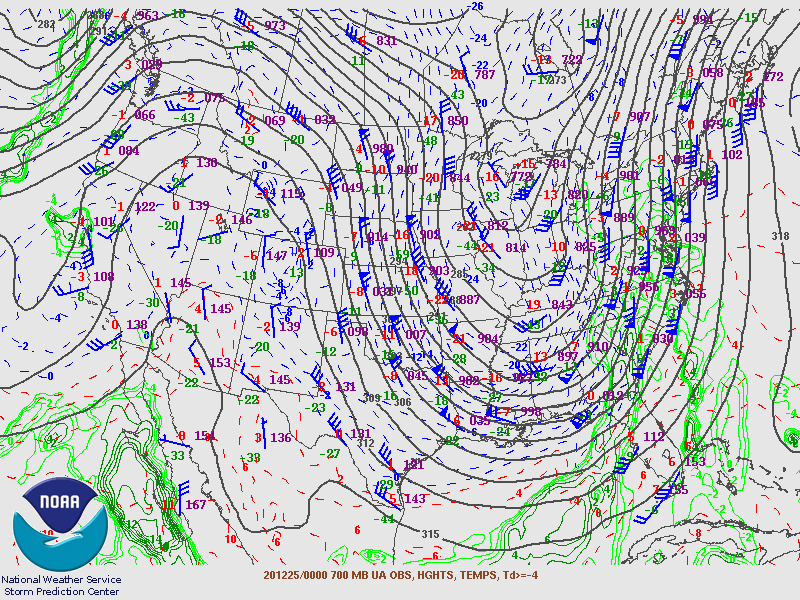
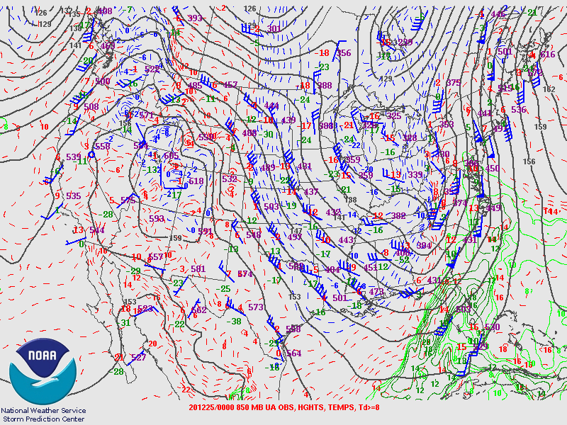
Environment
Synoptic Overview at 00z 25 Dec 2020 (courtesy of SPC)
 |
 |
 |
| Figure 1: 250MB Analysis | Figure 2: 300MB Analysis | Figure 3: 500MB Analysis |
 |
 |
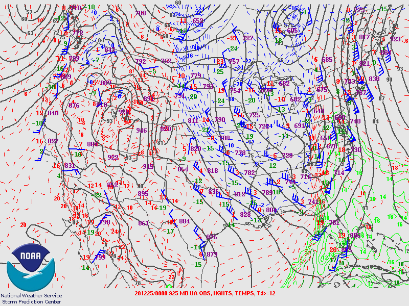 |
| Figure 4: 700MB Analysis | Figure 5: 850MB Analysis | Figure 6: 925MB Analysis |
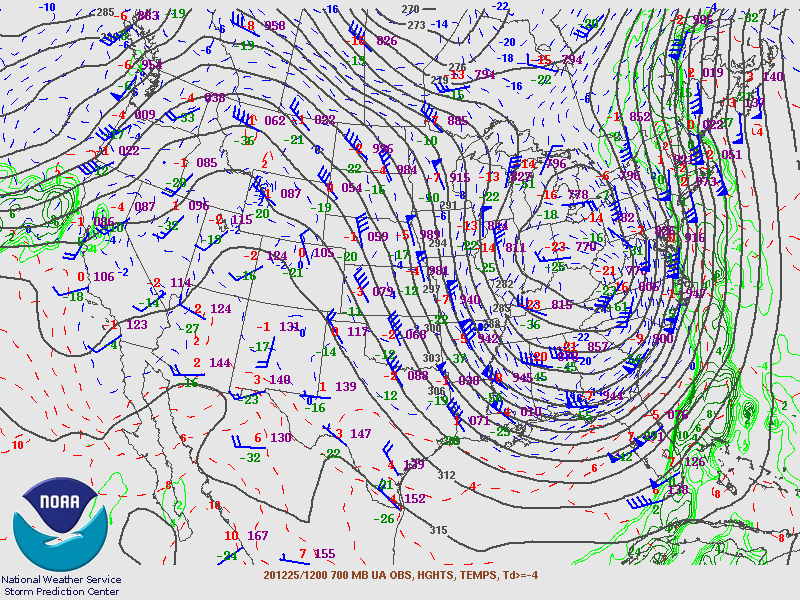
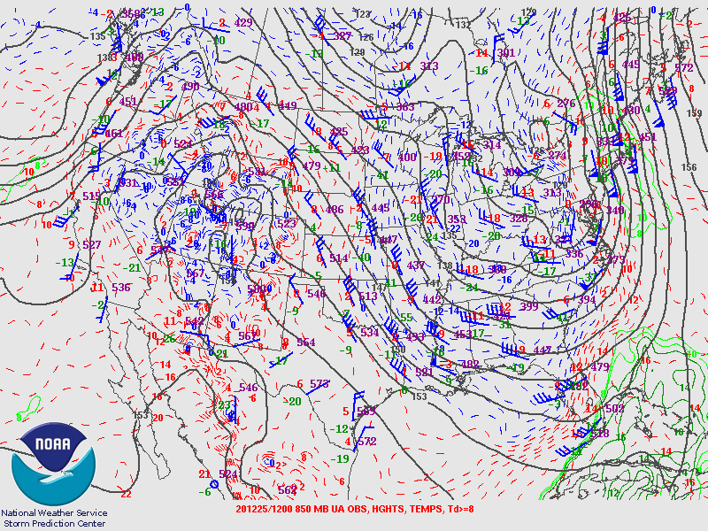
Synoptic Overview at 12z 25 Dec 2020 (courtesy of SPC)
 |
 |
 |
| Figure 7: 250MB Analysis | Figure 8: 300MB Analysis | Figure 9: 500MB Analysis |
 |
 |
 |
| Figure 10: 700MB Analysis | Figure 11: 850MB Analysis | Figure 12: 925MB Analysis |
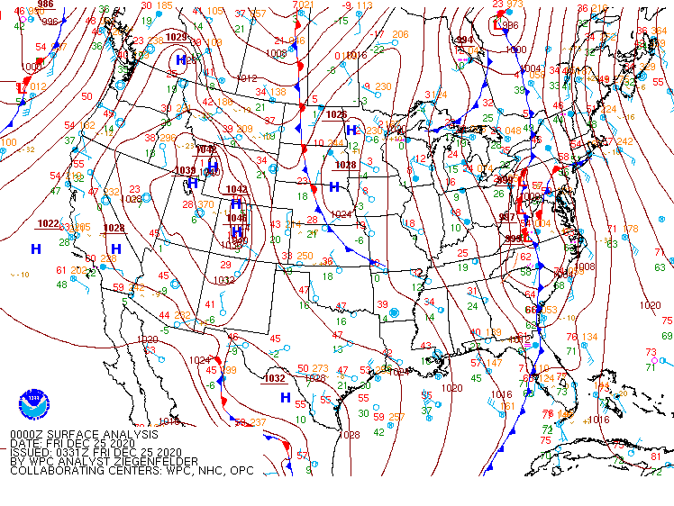
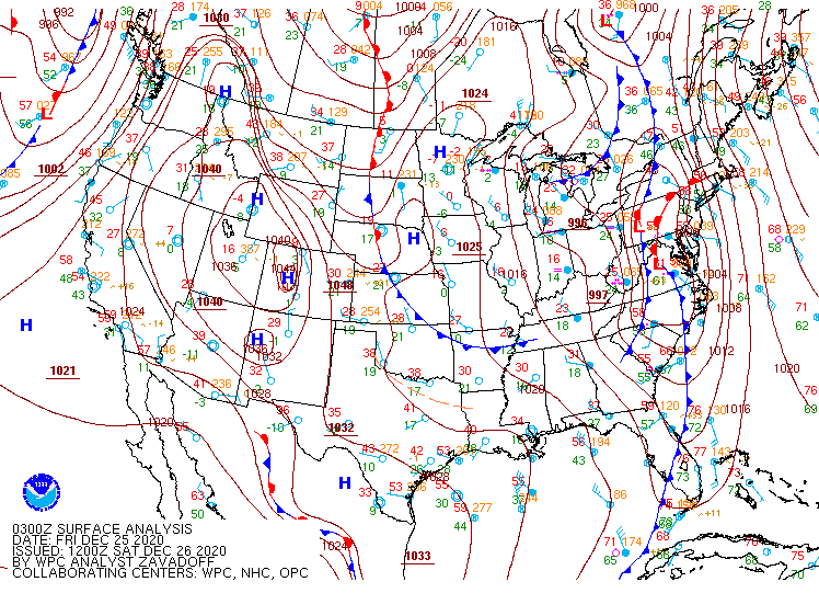
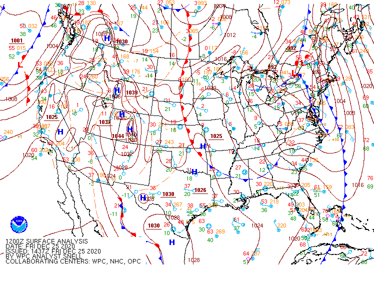
Surface Maps (courtesy of WPC)
 |
 |
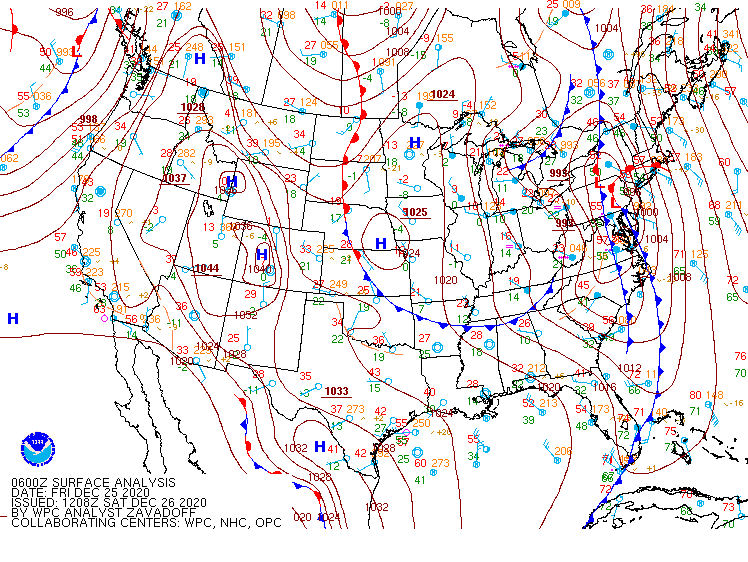 |
| Figure 13: Surface 122500Z | Figure 14: Surface 122503Z | Figure 15: Surface 122506Z |
 |
 |
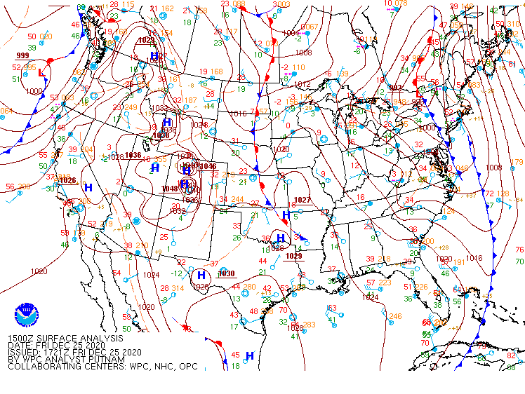 |
| Figure 16: Surface 122509Z | Figure 17: Surface 122512Z | Figure 18: Surface 122515Z |
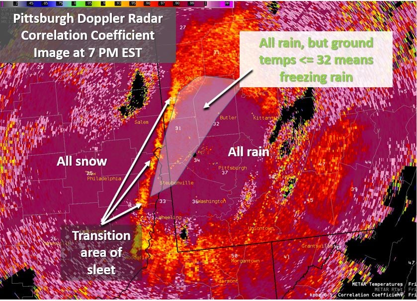
Dual Pol Radar data Correlation Coefficient returns. The arctic air filtering in behind the front changing precipitation types.
 |
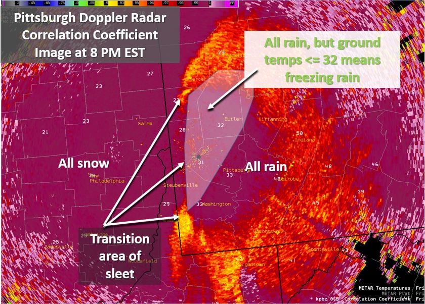 |
| Figure 19: 00Z 0.5 Degree Correlation Coefficient | Figure 20: 01Z 0.5 Degree Correlation Coefficient |
 |
Media use of NWS Web News Stories is encouraged! Please acknowledge the NWS as the source of any news information accessed from this site. |
|

