Overview
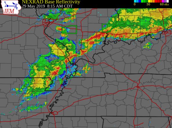
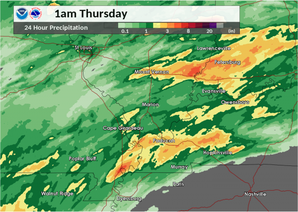
On May 29, 2019, severe thunderstorms and flash flooding struck much of the area. A morning round of thunderstorms produced an EF-1 tornado near Miner, MO, in Scott County. Later in the day, a supercell thunderstorm tracked from Caldwell County to Todd County in western Kentucky, producing hail up to golf ball size and wind damage. Sporadic straight-line wind damage occurred in Ripley, Butler, Scott, Mississippi, and New Madrid counties in southeast Missouri in the evening. Torrential rainfall produced flash flooding in southeast Illinois and southeast Missouri. Over 5 inches of rain fell near Albion, IL, and over 7 inches of rain fell in New Madrid, MO.Tornadoes:
|
Tornado - Near Miner, MO
Track Map 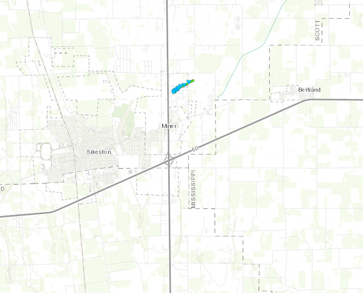 
Downloadable KMZ File not avbl |
||||||||||||||||
The Enhanced Fujita (EF) Scale classifies tornadoes into the following categories:
| EF0 Weak 65-85 mph |
EF1 Moderate 86-110 mph |
EF2 Significant 111-135 mph |
EF3 Severe 136-165 mph |
EF4 Extreme 166-200 mph |
EF5 Catastrophic 200+ mph |
 |
|||||
Wind & Hail:
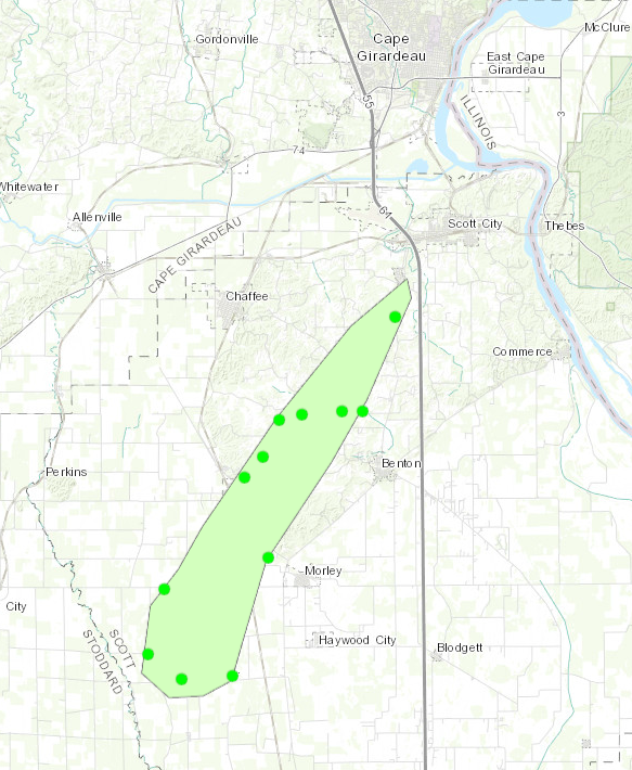
Scattered straight-line wind damage occurred across Scott County, primarily in the form of broken tree limbs and a few uprooted or snapped trees. At least one house was damaged from a large fallen tree limb. The area of scattered wind damage extended from southwest of Morley northeast to near Scott City. Peak winds in this area were estimated at 80 mph.
Wind
Hail
Very little hail was reported with the morning round of storms, other than a report of nickel-size hail in western Daviess County, KY.
The afternoon and evening round of storms contained some hail-producing storms. In the afternoon, a supercell in the Pennyrile region of western Kentucky produced a swath of quarter-size to golf-ball size hail from Princeton and Crofton, KY into parts of northern Todd and southern Muhlenberg County.
Flooding
Heavy rainfall and isolated flash flooding was reported with the morning round of storms in southwest Indiana. In the evening, the second round of storms renewed flash flooding in southwest Indiana. A new area of flash flooding developed in extreme southeast Missouri. Most of the flooding consisted of road flooding. A Cocorahs observer in New Madrid, MO reported 7.26 inches of rain in 24 hours.
24-hour rainfall ending at 1 A.M. Thurs., May 30
Storm Reports
PRELIMINARY LOCAL STORM REPORT...SUMMARY
NATIONAL WEATHER SERVICE PADUCAH KY
727 PM CDT THU MAY 30 2019

..TIME...   ...EVENT...      ...CITY LOCATION...     ...LAT.LON...
..DATE...   ....MAG....      ..COUNTY LOCATION..ST.. ...SOURCE....
            ..REMARKS..

0336 AM     TSTM WND GST     2 E MOUNT VERNON        38.32N 88.87W
05/29/2019  M43 MPH          JEFFERSON          IL   AWOS

            CORRECTS PREVIOUS NON-TSTM WND GST REPORT
            FROM 2 E MOUNT VERNON. AWOS STATION KMVN MT
            VERNON IL.

0745 AM     TSTM WND DMG     1 NNE MARION            37.75N 88.93W
05/29/2019                   WILLIAMSON         IL   BROADCAST MEDIA

            DELAYED REPORT. LARGE MAPLE TREE LIMBS DOWN
            ON THE NORTH SIDE OF MARION. TIME ESTIMATED.

0745 AM     TSTM WND GST     1 SE ENERGY             37.77N 89.02W
05/29/2019  M52 MPH          WILLIAMSON         IL   AWOS

            AWOS STATION KMWA MARION IL.

0753 AM     TSTM WND DMG     CAPE GIRARDEAU          37.30N 89.56W
05/29/2019                   CAPE GIRARDEAU     MO   PUBLIC

            DELAYED REPORT. TREES REPORTED DOWN AROUND
            CAPE GIRARDEAU, INCLUDING A TREE THAT FELL
            ONTO A HOUSE. TIME ESTIMATED FROM RADAR.

0844 AM     TORNADO          1 NNE MINER             36.91N 89.53W
05/29/2019                   SCOTT              MO   NWS STORM SURVEY

            AN EF1 TORNADO RESULTED IN A HOUSE LOOSING A
            PORTION OF ITS ROOF INCLUDING THE ROOF
            DECKING. SEVERAL SMALL OUTBUILDINGS OR
            PORCHES LOST PART OF THEIR ROOFS OR WALLS.
            AT LEAST A COUPLE DOZEN TREES HAD BROKEN
            TREE LIMBS AND A FEW SMALLER TREES WERE
            UPROOTED OR BROKEN.

0930 AM     HEAVY RAIN       ALBION                  38.38N 88.06W
05/29/2019  M5.00 INCH       EDWARDS            IL   TRAINED SPOTTER

            STORM TOTAL AS OF 9:30 AM.

0958 AM     FLASH FLOOD      3 SW ELBERFELD          38.12N 87.48W
05/29/2019                   VANDERBURGH        IN   EMERGENCY MNGR

            BASELINE ROAD FLOODED WEST OF PETERSBURG
            ROAD.

1030 AM     HAIL             5 S STANLEY             37.76N 87.26W
05/29/2019  E0.88 INCH       DAVIESS            KY   PUBLIC

            DIME TO NICKEL SIZE HAIL REPORTED IN WESTERN
            DAVIESS COUNTY.

0125 PM     HAIL             5 ESE PRINCETON         37.07N 87.81W
05/29/2019  E1.00 INCH       CALDWELL           KY   BROADCAST MEDIA

            REPORTED SOUTHEAST OF PRINCETON ALONG KY
            HIGHWAY 91.

0143 PM     HAIL             CROFTON                 37.05N 87.48W
05/29/2019  E1.00 INCH       CHRISTIAN          KY   TRAINED SPOTTER

            DELAYED REPORT. DIME TO QUARTER SIZE HAIL.
            TIME ESTIMATED.

0149 PM     HAIL             CROFTON                 37.05N 87.48W
05/29/2019  E0.70 INCH       CHRISTIAN          KY   TRAINED SPOTTER


0216 PM     HAIL             3 NW CLIFTY             37.03N 87.19W
05/29/2019  E0.25 INCH       TODD               KY   EMERGENCY MNGR


0216 PM     TSTM WND DMG     4 WNW CLIFTY            37.01N 87.23W
05/29/2019                   TODD               KY   EMERGENCY MNGR

            TREES DOWN ALONG CLIFTY-KIRKMANSVILLE ROAD.
            TIME ESTIMATED BY RADAR.

0230 PM     HAIL             3 NE CLIFTY             37.03N 87.11W
05/29/2019  E1.50 INCH       TODD               KY   PUBLIC

            QUARTER TO PING PONG SIZED HAIL AND TREES
            DOWNED ON JASON RIDGE ROAD, NEAR LAKE
            MALONE, IN NORTHEAST TODD COUNTY.

0235 PM     TSTM WND DMG     4 NNW HOPKINSVILLE      36.90N 87.53W
05/29/2019                   CHRISTIAN          KY   EMERGENCY MNGR

            TREES DOWN IN THE PRINCETON ROAD AND DAWSON
            SPRINGS ROAD AREA. TIME ESTIMATED BY RADAR.

0238 PM     HAIL             DUNMOR                  37.08N 87.00W
05/29/2019  E1.75 INCH       MUHLENBERG         KY   911 CALL CENTER

            HALF DOLLAR TO GOLFBALL SIZE HAIL.

0359 PM     HAIL             3 NE CHARLESTON         36.95N 89.29W
05/29/2019  E0.70 INCH       MISSISSIPPI        MO   BROADCAST MEDIA


0418 PM     TSTM WND DMG     CAIRO                   37.00N 89.18W
05/29/2019                   ALEXANDER          IL   LAW ENFORCEMENT

            TREE LIMBS DOWN AND A CARPORT FLIPPED OVER.

0550 PM     TSTM WND DMG     DONIPHAN                36.62N 90.82W
05/29/2019                   RIPLEY             MO   EMERGENCY MNGR

            TREES DOWN IN DONIPHAN. ONE HOME SUSTAINED
            ROOF DAMAGE FROM FALLEN TREE.

0553 PM     TSTM WND GST     DONIPHAN                36.62N 90.80W
05/29/2019  M65 MPH          RIPLEY             MO   OTHER FEDERAL

            WIND GUST MEASURED AT RAWS OBSERVATION
            STATION IN DONIPHAN.

0555 PM     TSTM WND DMG     DONIPHAN                36.62N 90.82W
05/29/2019                   RIPLEY             MO   LAW ENFORCEMENT

            MANY TREES DOWN THROUGHOUT THE COUNTY.
            NUMEROUS POWER OUTAGES AS WELL. TIME
            ESTIMATED BY RADAR.

0558 PM     TSTM WND DMG     5 N OXLY                36.67N 90.71W
05/29/2019                   RIPLEY             MO   TRAINED SPOTTER

            LATE REPORT. TREES DOWN AND 60 MPH WIND GUST
            ESTIMATED.

0605 PM     TSTM WND DMG     2 E FARIDEALING         36.66N 90.59W
05/29/2019                   BUTLER             MO   PUBLIC

            MEDIUM SIZED TREE BRANCHES DOWN EAST OF
            FAIRDEALING. TIME ESTIMATED BY RADAR.

0640 PM     FLASH FLOOD      NEW MADRID              36.59N 89.53W
05/29/2019                   NEW MADRID         MO   LAW ENFORCEMENT

            WATER OVER NUMEROUS ROADS IN THE TOWN OF NEW
            MADRID INCLUDING HWY 61 IN FRONT OF THE HIGH
            SCHOOL.

0645 PM     TSTM WND GST     DUDLEY                  36.80N 90.09W
05/29/2019  E46 MPH          STODDARD           MO   TRAINED SPOTTER

            WIND GUST MEASURED ON HOME ANEMOMETER.

0650 PM     TSTM WND DMG     5 NNW DEXTER            36.85N 90.00W
05/29/2019                   STODDARD           MO   LAW ENFORCEMENT

            NUMEROUS TREES DOWN FROM DEXTER TO PUXICO
            DUE TO SEVERE WIND GUSTS. POWER LINES DOWN
            AS WELL.

0650 PM     TSTM WND DMG     DEXTER                  36.79N 89.96W
05/29/2019                   STODDARD           MO   EMERGENCY MNGR

            TREES DOWN ON ROADS AND HOMES IN DEXTER.

0725 PM     TSTM WND DMG     ORAN                    37.09N 89.65W
05/29/2019                   SCOTT              MO   LAW ENFORCEMENT

            TREES DOWN ACROSS THE COUNTY.

0737 PM     TSTM WND GST     2 W SCOTT CITY          37.22N 89.57W
05/29/2019  E60 MPH          SCOTT              MO   ASOS

            MEASURED WIND GUST AT CAPE GIRARDEAU
            REGIONAL AIRPORT KCGI ASOS.

0945 PM     FLOOD            1 N JEFFERSONVILLE      38.46N 88.40W
05/29/2019                   WAYNE              IL   LAW ENFORCEMENT

            LATE REPORT. HAD SOME WATER ON HWY 45 JUST
            NORTH OF GEFF EARLIER THIS EVENING. TIME
            ESTIMATED. THIS IS A FLOOD PRONE LOCATION.

0945 PM     HEAVY RAIN       1 N CAIRO               37.01N 89.18W
05/29/2019  M3.47 INCH       ALEXANDER          IL   CO-OP OBSERVER

            RAINFALL SINCE MIDNIGHT.

1000 PM     FLASH FLOOD      3 SSW FRANCISCO         38.30N 87.47W
05/29/2019                   GIBSON             IN   LAW ENFORCEMENT

            WATER RESCUE ALONG S COUNTY ROAD 550 E SOUTH
            OF FRANCISCO. NO ADDITIONAL DETAILS KNOWN AT
            THIS TIME.

1105 PM     FLASH FLOOD      4 NNW WINSLOW           38.44N 87.25W
05/29/2019                   PIKE               IN   LAW ENFORCEMENT

            SEVERAL INCHES OF WATER FLOWING OVER THE
            ROAD NEAR THE HWY 61/HWY 56 JUNCTION SOUTH
            OF PETERSBURG AND ALONG HWY 356 JUST WEST OF
            THE HWY 257 INTERSECTION WEST OF OTWELL.

0700 AM     HEAVY RAIN       SE NEW MADRID           36.59N 89.55W
05/30/2019  M7.19 INCH       NEW MADRID         MO   COCORAHS

            24-HOUR RAINFALL.

0700 AM     HEAVY RAIN       1 ENE NEW MADRID        36.59N 89.53W
05/30/2019  M7.26 INCH       NEW MADRID         MO   COCORAHS

            24-HR RAINFALL.
Rain Reports
PUBLIC INFORMATION STATEMENT
NATIONAL WEATHER SERVICE PADUCAH KY
734 PM CDT THU MAY 30 2019

...48 HOUR PRECIPITATION REPORTS ENDING AT 730 PM THURSDAY MAY 30 2019...

LOCATION                     AMOUNT    TIME/DATE       PROVIDER
1 E NEW MADRID               7.26 IN   0700 AM 05/30   COCORAHS
NEW MADRID                   7.19 IN   0700 AM 05/30   COCORAHS
1 N CAIRO                    3.47 IN   0945 PM 05/29   CO-OP OBSERVER
ELKTON                       3.31 IN   0716 PM 05/30   CWOP
4 SE ALLEGRE                 3.22 IN   0731 PM 05/29   TRAINED SPOTTER
MOUNT CARMEL                 3.11 IN   0724 PM 05/30   AWS
BENTON KY 4 N                3.08 IN   0715 PM 05/30   KYMN
MAYFIELD KY 6 SW             2.86 IN   0715 PM 05/30   KYMN
FAIRFIELD IL                 2.75 IN   0715 PM 05/30   AWOS
PRINCETON KY 2 SE            2.71 IN   0715 PM 05/30   KYMN
WICKLIFFE                    2.58 IN   0721 PM 05/30   CWOP
PETERSBURG IN 1 ENE          2.56 IN   0600 AM 05/30   COCORAHS
MADISONVILLE KY 4 S          2.55 IN   0715 PM 05/30   KYMN
LYNNVILLE                    2.52 IN   0725 PM 05/30   CWOP
MOUNT CARMEL                 2.52 IN   0739 PM 05/29   AWS
HICKMAN KY 2 E               2.44 IN   0715 PM 05/30   KYMN
BEAN RIDGE IL                2.39 IN   0708 PM 05/30   RAWS
DIXON 1 NW                   2.27 IN   0715 PM 05/30   KYMN
LYNNVILLE                    2.21 IN   0735 PM 05/29   CWOP
MT VERNON IL                 2.13 IN   0656 PM 05/30   AWOS
WICKLIFFE                    2.01 IN   0737 PM 05/29   CWOP
3 SSE BARLOW                 2.01 IN   0737 PM 05/29   TRAINED SPOTTER
PRINCETON                    1.99 IN   0715 PM 05/30   CWOP
CALHOUN KY 5 NW              1.91 IN   0715 PM 05/30   KYMN
MARION KY 4 NE               1.89 IN   0715 PM 05/30   KYMN
1 N HOPKINSVILLE             1.73 IN   0725 PM 05/30   AWS
WHITESVILLE                  1.71 IN   0725 PM 05/30   AWS
WADESVILLE                   1.67 IN   0716 PM 05/30   CWOP
2 N HOPKINSVILLE             1.65 IN   0740 PM 05/29   TRAINED SPOTTER

OBSERVATIONS ARE COLLECTED FROM A VARIETY OF SOURCES WITH VARYING
EQUIPMENT AND EXPOSURES. WE THANK ALL VOLUNTEER WEATHER OBSERVERS
FOR THEIR DEDICATION. NOT ALL DATA LISTED ARE CONSIDERED OFFICIAL.
 |
Media use of NWS Web News Stories is encouraged! Please acknowledge the NWS as the source of any news information accessed from this site. |
|