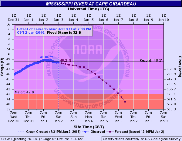
The following are the old records and the preliminary new record crests for the Cape Girardeau, MO and Thebes, IL river gages:
Cape Girardeau, MO: Old record was 48.49 set in August of 1993. The river crested at a new record of 48.86 feet on the evening of January 1.
Thebes, IL: Old record was 45.91 set in May of 1995. The river crested at a new record of 47.74 feet around 1 A.M. on January 2. The river crest would likely have been higher if the levee break had not occurred in Alexander County.
Below is a photo of the breach in the Len Small Levee near Miller City, Illinois. This image was obtained from a video taken by the Illinois State Police and posted on the Illinois Emergency Management Agency Facebook page. The video was taken on January 2.

Below is a photo of the approach to the Ohio River bridge on U.S. Highway 51/60/62 between Cairo, IL and Wickliffe, KY. The photo was taken on January 4, courtesy of the Kentucky Transportation Cabinet. Floodwaters normally cover the Kentucky side of the bridge approach when the Cairo river gage reaches 54 to 55 feet.

Below is a photo of the Thebes, Illinois riverfront, taken a few days after the river crested. Photo taken Jan. 4 by NWS Paducah staff.
Below is a photo taken at Olive Branch in Alexander County, IL after the river had fallen a few feet from its record crest. Photo taken Jan. 4 by NWS Paducah staff.

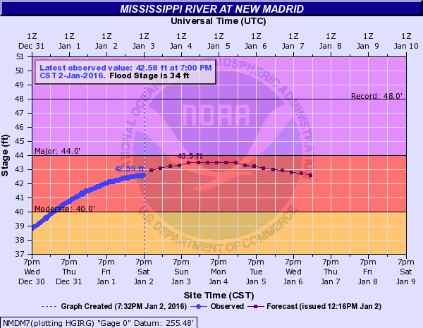
The following are the archived hydrographs for the Mississippi River at Cape Girardeau, Thebes, and New Madrid, followed by Cairo, IL. The Cairo gage is technically on the Ohio River, but it is strongly affected by backwater from the Mississippi River.


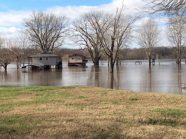
OTHER IMPACTS: There were numerous road closures. The Ohio River bridge between Wickliffe, KY and Cairo, IL was closed on December 31 due to high water over the Kentucky side of U.S. Highway 51/60/62. The road reopened a week later. The Governor of Illinois issued a disaster declaration for some of the hardest-hit counties. A number of homes were flooded on both the Illinois and Missouri sides of the river. The city government of Cape Girardeau estimated 20 homes and 8 businesses were flooded in the Red Star neighborhood. Media reports indicated several dozen homes in Alexander County, IL were flooded.

