
In the Upper Midwest, heavy to excessive rain may bring flash and urban flooding through Wednesday. Scattered severe thunderstorms capable of large hail and damaging wind gusts are possible from the central High Plains into the Upper Midwest Wednesday. Extreme heat is ongoing over the Desert Southwest through Thursday. Read More >
Overview
Clusters of thunderstorms formed over southwest Indiana and western Kentucky early in the afternoon. Several of these storms produced large hail or damaging wind. However, the main event was a line of severe thunderstorms that entered southeast Missouri about mid-afternoon and then tracked east across western Kentucky and far southern Illinois late in the afternoon and early in the evening. Corridors of intense wind damage were associated with this line, including 7 EF-1 tornadoes. One of these tornadoes touched down in Paducah, causing damage to the Lone Oak, Hendron, and south side areas of town.Tornadoes:
|
|
||||||||||
|
||||||||||
|
Tornado #1 - Paducah, KY
Track Map
Zoomed In Track over Paducah
|
||||||||||||||||
|
Tornado #2- Moors Marina, KY
Track Map .png) 
|
||||||||||||||||
|
Tornado #3- Bardwell, KY Northwest
Track Map .png)
|
||||||||||||||||
|
Tornado #4- Blandville, KY Southeast
Track Map .png)
|
||||||||||||||||
|
Tornado #5 - Smithland, KY
Track Map .png)
|
||||||||||||||||
|
Tornado #6 - Smithland, KY Northeast
Track Map .png)
|
||||||||||||||||
|
Tornado #7 - NW of Golconda, IL
Track Map 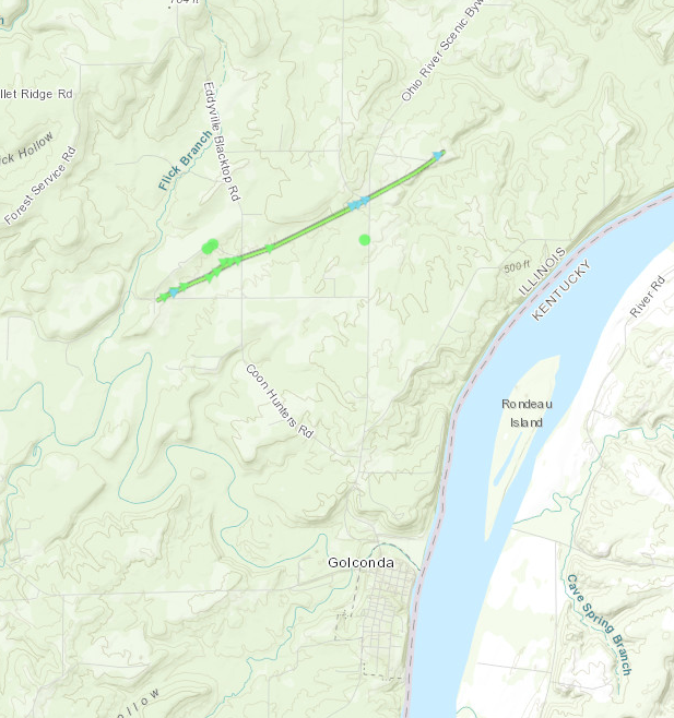
|
||||||||||||||||
The Enhanced Fujita (EF) Scale classifies tornadoes into the following categories:
| EF0 Weak 65-85 mph |
EF1 Moderate 86-110 mph |
EF2 Significant 111-135 mph |
EF3 Severe 136-165 mph |
EF4 Extreme 166-200 mph |
EF5 Catastrophic 200+ mph |
 |
|||||
Wind & Hail:
Wind
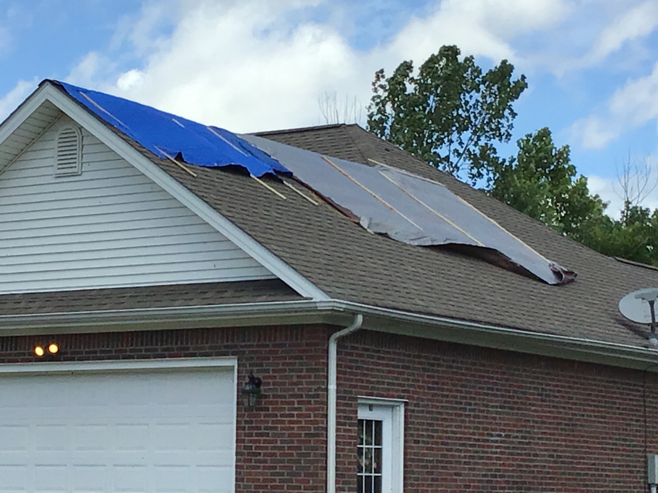
The most extensive corridors of wind damage appeared to extend across far western Kentucky. One swath of damage extended from around Bardwell in Carlisle County to just south of Paducah and then northeast into Livingston County. A second corridor extended just south of the first one. This second damage area was from the Carlisle/Hickman County border east-northeast across northern Graves County, then across Marshall County into the northern part of the Land Between The Lakes. Numerous trees were blown down in those areas, blocking roads and downing power lines. Some minor roof damage occurred.
Damage was more sporadic elsewhere. There were pockets of very strong winds in the Pennyrile region of west Kentucky, especially from Mclean County south across Providence and Madisonville. Multiple trees were blown down in those areas.
Hail
Similar to the Friday (June 21) severe weather outbreak, large hail reports were again few and far between. Most of the hail occurred with the clusters of storms that developed over western Kentucky early in the afternoon, when hailstones up to quarter-size fell near Owensboro. The squall line later in the day was not associated with much in the way of hail.
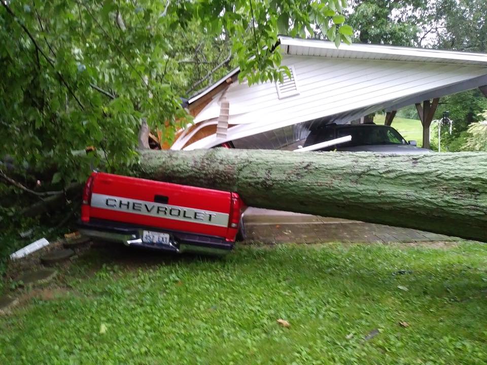
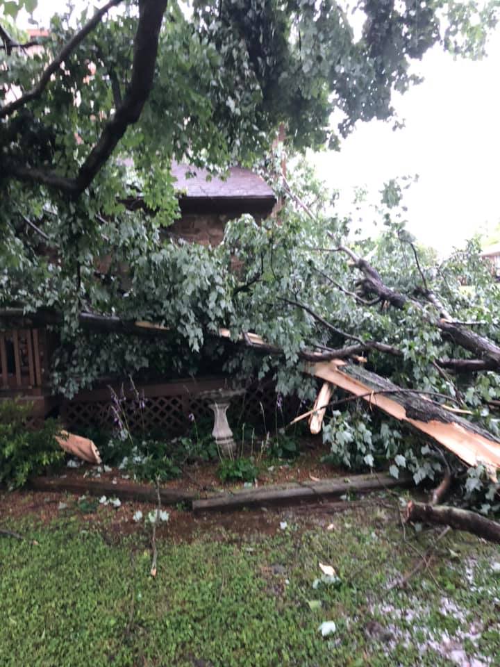
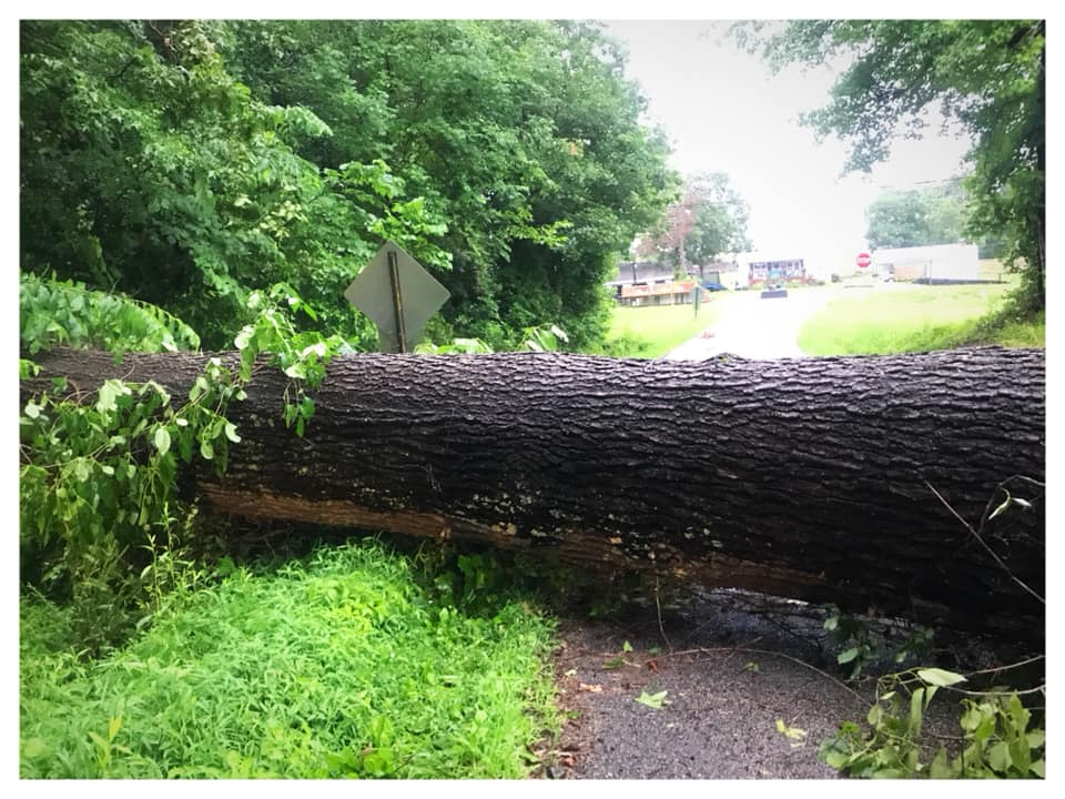
Photos
Damage photos (click for full size)
 |
 |
 |
 |
| Moors Resort (on Kentucky Lake) (Rachel Pillion) |
Wind damage in Livermore, KY (Yvette Nelson) |
Lone Oak (near Paducah), KY (Ramona Milles) |
Madisonville, KY (Kelly Gates) |
 |
 |
||
| Tornado Damage in Lone Oak, KY - NWS Storm Damage Survey | Tornado Damage at Moors Marina - NWS Storm Damage Survey |
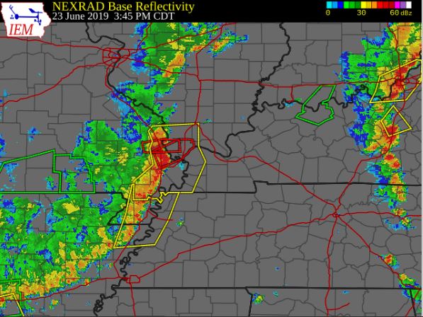
Radar
Click here for a radar loop of this event
 |
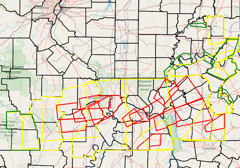
The graphic below shows all of the Severe Thunderstorm, Tornado, Flash Flood Warnings, and Flood Advisories issued during the event.
 |
Storm Reports
Below is a map of preliminary storm reports. All icons are high wind reports except for the purple icons (hail) and the red icon (funnel cloud).PRELIMINARY LOCAL STORM REPORT...SUMMARY NATIONAL WEATHER SERVICE PADUCAH KY 1128 PM CDT SUN JUN 23 2019 ..TIME... ...EVENT... ...CITY LOCATION... ...LAT.LON... ..DATE... ....MAG.... ..COUNTY LOCATION..ST.. ...SOURCE.... ..REMARKS.. 1246 PM TSTM WND DMG 1 N PETERSBURG 38.50N 87.28W 06/23/2019 PIKE IN LAW ENFORCEMENT DELAYED REPORT. NUMEROUS TREES AND POWER LINES DOWN NORTH OF PETERSBURG AND IN WINSLOW. 0106 PM TSTM WND GST WINGO 36.64N 88.74W 06/23/2019 E50 MPH GRAVES KY PUBLIC 0134 PM TSTM WND DMG 3 NNE CHRISNEY 38.05N 87.02W 06/23/2019 SPENCER IN LAW ENFORCEMENT DELAYED REPORT. TWO TREES DOWN ON COUNTY ROAD 1100 NORTH. ONE TREE DOWN WEST OF COUNTY ROAD 600 EAST AND ONE TREE DOWN EAST OF COUNTY ROAD 600 EAST. 0143 PM HAIL MURRAY 36.61N 88.32W 06/23/2019 M0.88 INCH CALLOWAY KY PUBLIC . 0150 PM TSTM WND DMG REED 37.86N 87.36W 06/23/2019 HENDERSON KY TRAINED SPOTTER SEVERAL TREES DOWN AND POWER IS OUT. 0150 PM FUNNEL CLOUD 3 WNW KIRKSEY 36.70N 88.48W 06/23/2019 CALLOWAY KY PUBLIC . 0154 PM TSTM WND DMG 6 S ELLSINORE 36.85N 90.75W 06/23/2019 CARTER MO EMERGENCY MNGR TREES DOWN ON HWY B BETWEEN HIGHWAY 21 AND HWY 60. 0200 PM TSTM WND GST HUNTER 36.89N 90.84W 06/23/2019 M55 MPH CARTER MO TRAINED SPOTTER 0200 PM TSTM WND DMG PENROD 37.12N 87.00W 06/23/2019 MUHLENBERG KY LAW ENFORCEMENT DELAYED REPORT. TREE DOWN NEAR STATE ROAD 949. ADDITIONAL REPORT OF TREE DOWN NEAR GREENVILLE. 0212 PM HAIL 3 NW OWENSBORO 37.79N 87.16W 06/23/2019 E1.00 INCH DAVIESS KY TRAINED SPOTTER NICKEL TO QUARTER SIZE HAIL. 0219 PM TSTM WND DMG 5 WSW POPLAR BLUFF 36.74N 90.49W 06/23/2019 BUTLER MO LAW ENFORCEMENT ROOF DAMAGE AND TREES DOWN ON COUNTY ROAD 470. LOTS OF TREES DOWN IN THAT SAME GENERAL AREA. 0219 PM TSTM WND DMG 9 WSW POPLAR BLUFF 36.71N 90.56W 06/23/2019 BUTLER MO TRAINED SPOTTER TREES DOWN ON A HOUSE AND CARS ON COUNTY ROAD 461. 0322 PM TSTM WND DMG DELTA 37.20N 89.74W 06/23/2019 CAPE GIRARDEAU MO TRAINED SPOTTER SIDING PEELED BACK ON A HOUSE AND TREE LIMBS DOWN. 0338 PM TSTM WND GST 4 SW CAPE GIRARDEAU 37.27N 89.60W 06/23/2019 E60 MPH CAPE GIRARDEAU MO TRAINED SPOTTER CORRECTS PREVIOUS TSTM WND GST REPORT FROM 4 SW CAPE GIRARDEAU. 60 MPH WINDS REPORTED AT EXIT 93 ON INTERSTATE 55 NORTHBOUND. 0417 PM TSTM WND DMG 4 SE BROWNWOOD 37.03N 89.90W 06/23/2019 STODDARD MO PUBLIC LARGE TREE TIME DOWN. TIME ESTIMATED. 0422 PM TSTM WND DMG CHARLESTON 36.92N 89.34W 06/23/2019 MISSISSIPPI MO PUBLIC MPING REPORT OF ONE INCH LIMBS DOWN BETWEEN CHARLESTON AND WYATT. 0426 PM TSTM WND DMG 1 SW BLANDVILLE 36.93N 88.97W 06/23/2019 BALLARD KY PUBLIC TWO TREES SNAPPED. TIME ESTIMATED. 0429 PM TSTM WND GST BARDWELL 36.87N 89.01W 06/23/2019 E55 MPH CARLISLE KY PUBLIC 0440 PM TSTM WND DMG FANCY FARM 36.80N 88.79W 06/23/2019 GRAVES KY PUBLIC LARGE TREE DOWN ON HOME. TIME ESTIMATED. 0443 PM TSTM WND DMG 3 N MELBER 37.00N 88.73W 06/23/2019 MCCRACKEN KY PUBLIC STRUCTURAL DAMAGE ON A FARM, INCLUDING SECTIONS OF ROOFS REMOVED, DAMAGED GRAIN BINS, AND TREE DAMAGE. TIME ESTIMATED. 0445 PM TSTM WND DMG 2 SW LONE OAK 37.02N 88.69W 06/23/2019 MCCRACKEN KY PUBLIC SEVERAL OLD GROWTH TREES UPROOTED, SEVERAL LARGE HEALTHY BRANCHES DOWN, SIDING RIPPED OFF POLE BARN. TIME ESTIMATED. 0448 PM TSTM WND DMG HICKORY 36.82N 88.65W 06/23/2019 GRAVES KY PUBLIC TREE DAMAGE WITH A SEMI TRUCK OVERTURNED NEAR PILGRIMS PRIDE. METAL OUTBUILDING WITH DAMAGE. TIME ESTIMATED. 0449 PM TSTM WND GST 4 W PADUCAH 37.07N 88.71W 06/23/2019 M62 MPH MCCRACKEN KY TRAINED SPOTTER 0453 PM TSTM WND DMG 3 SE PADUCAH 37.04N 88.60W 06/23/2019 MCCRACKEN KY TRAINED SPOTTER RESTAURANT SIGNS BLOWN DOWN AND WINDOWS BLOWN OUT OF STOREFRONT ON SOUTHSIDE OF PADUCAH. 0453 PM TSTM WND DMG REIDLAND 37.01N 88.53W 06/23/2019 MCCRACKEN KY PUBLIC LARGE TREE FELL DOWN ONTO A FENCE AND THE SIDE OF A HOUSE. TIME ESTIMATED. 0453 PM TSTM WND DMG 3 E PADUCAH 37.07N 88.59W 06/23/2019 MCCRACKEN KY TRAINED SPOTTER ROOF DAMAGE TO A FORMER CHURCH. TIME ESTIMATED. 0453 PM TSTM WND DMG 5 SW SYMSONIA 36.84N 88.56W 06/23/2019 GRAVES KY PUBLIC TREES DOWN. TIME ESTIMATED. 0454 PM TSTM WND DMG 1 E REIDLAND 37.01N 88.50W 06/23/2019 MCCRACKEN KY PUBLIC SOFFIT BLOWN OFF A HOME. 0504 PM TSTM WND DMG SMITHLAND 37.14N 88.40W 06/23/2019 LIVINGSTON KY PUBLIC MOBILE HOME DESTROYED. TIME ESTIMATED. 0505 PM TSTM WND DMG SMITHLAND 37.14N 88.40W 06/23/2019 LIVINGSTON KY PUBLIC CHURCH IN TOWN HAS MAJOR ROOF DAMAGE. 0507 PM TSTM WND DMG 4 NE BENTON 36.90N 88.33W 06/23/2019 MARSHALL KY PUBLIC TREES DOWN. TIME ESTIMATED. 0515 PM TSTM WND DMG 7 WSW SALEM 37.25N 88.36W 06/23/2019 LIVINGSTON KY PUBLIC LARGE TREE DOWN. TIME ESTIMATED. 0515 PM TSTM WND DMG 3 N GOLCONDA 37.41N 88.49W 06/23/2019 POPE IL EMERGENCY MNGR WIND DAMAGE INCLUDING TREES DOWN ON EDDYVILLE BLACKTOP ROAD. 0515 PM TSTM WND DMG 7 E DRAFFENVILLE 36.94N 88.21W 06/23/2019 MARSHALL KY BROADCAST MEDIA MAJOR DAMAGE AT MOORS MARINA. 0520 PM TSTM WND DMG SALEM 37.27N 88.24W 06/23/2019 LIVINGSTON KY PUBLIC POWER LINES DOWN AND LARGE TREES UPROOTED IN AND NEAR SALEM. WINDOWS BLOWN OUT OF BUSINESS DOWNTOWN SALEM. 0544 PM TSTM WND DMG 1 SW PROVIDENCE 37.39N 87.76W 06/23/2019 WEBSTER KY PUBLIC LARGE TREES AND POWER LINES DOWN, INCLUDING TREES ON HOUSES. TIME ESTIMATED. 0545 PM TSTM WND DMG PROVIDENCE 37.40N 87.75W 06/23/2019 WEBSTER KY FIRE DEPT/RESCUE NUMEROUS TREES DOWN IN PROVIDENCE IN THE TOWER DRIVE - BAPTIST HILL AREA. 0545 PM LIGHTNING MURRAY 36.61N 88.32W 06/23/2019 CALLOWAY KY TRAINED SPOTTER PERSON STRUCK BY LIGHTNING AT MURRAY STATE UNIVERSITY CAMPUS. ENROUTE TO HOSPITAL. 0552 PM TSTM WND DMG 6 N DAWSON SPRINGS 37.27N 87.68W 06/23/2019 HOPKINS KY PUBLIC TREE DOWN NEAR SIXTH VEIN ROAD AND HIGHWAY 70. TIME ESTIMATED. 0620 PM TSTM WND DMG ROBARDS 37.68N 87.55W 06/23/2019 HENDERSON KY EMERGENCY MNGR WIRES DOWN. TIME ESTIMATED. 0623 PM TSTM WND DMG LIVERMORE 37.50N 87.13W 06/23/2019 MCLEAN KY PUBLIC TREE DOWN ON A HOUSE. ROOF TORN OFF A TOOL SHED. TIME ESTIMATED. 0626 PM TSTM WND DMG 2 NE LIVERMORE 37.51N 87.11W 06/23/2019 MCLEAN KY PUBLIC LARGE TREE THAT WAS 100 TO 150 YEARS OLD UPROOTED. TIME ESTIMATED. 0626 PM TSTM WND DMG MOORMAN 37.38N 87.14W 06/23/2019 MUHLENBERG KY PUBLIC LARGE TREE DOWN. TIME ESTIMATED. 0637 PM TSTM WND GST 3 WSW OWENSBORO 37.74N 87.17W 06/23/2019 E53 MPH DAVIESS KY AWOS REPORT FROM OWENSBORO-DAVIESS COUNTY AIRPORT AUTOMATED WEATHER OBSERVATION STATION. &&
.
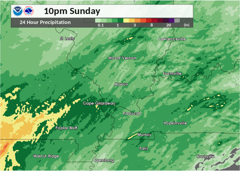
Rain Reports
Rainfall was locally heavy, however flooding was not a widespread issue. Below is the radar-estimated rainfall map for the 24-hour period ending 10 PM June 23.
 |
Media use of NWS Web News Stories is encouraged! Please acknowledge the NWS as the source of any news information accessed from this site. |
|


.png)
%20Zoomed%20In.png)