National Weather Service United States Department of Commerce

 Severe Weather       Heavy Rain & Flooding       Drought       Extreme Heat       Winter: Snow       Ice       Cold

Satellite Storm Total Snow Forecast Graphical Forecast
Current Weather Forecast Maps
     
Paducah Radar Evansville Radar Fort Campbell Radar
KPAH Radar KVWX Radar KHPX Radar
     
Weather Story Current Hazards Graphical Nowcast
Weather Story Graphical Nowcast
   
Weather Information: Watches, Warnings, Storm Reports, Forecast Products, etc.
   
Click this link for our experimental Probabilistic Snow and Ice Accumulation graphics.
   

General Forecast Products

Other Local Products


Road Condition Pages

Latest Weather Observations

 
Weather Prediction Center (WPC) Forecasts
 
WPC Composite Charts
     

Day 1

WPC Day 1 Composite Chart

Day 2

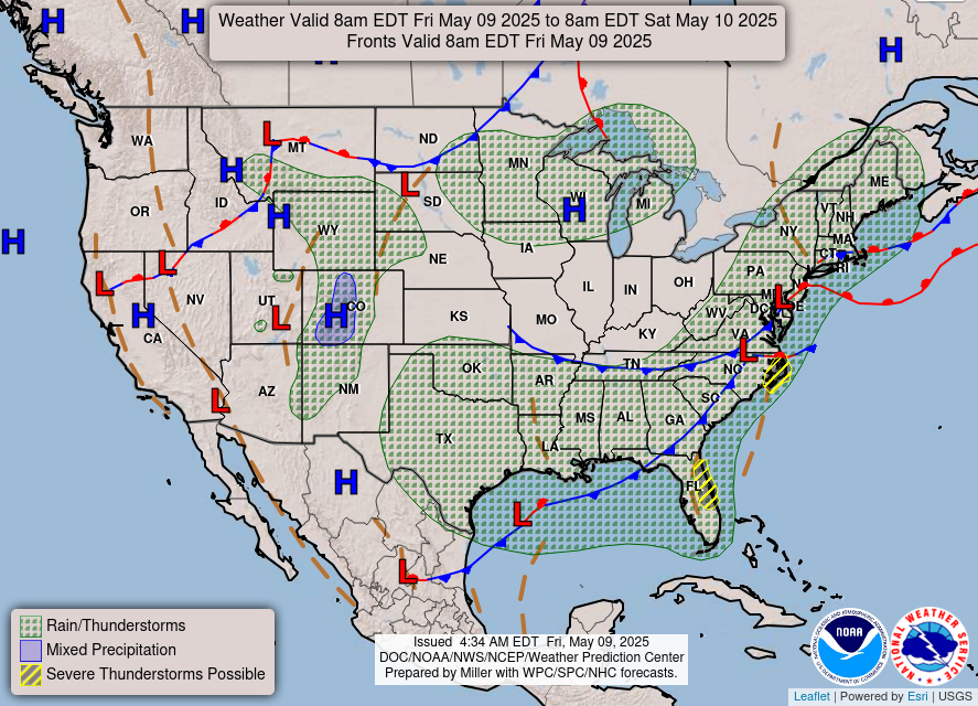
WPC Day 2 Composite Chart

Day 3

WPC Day 3 Composite Chart

     
WPC Freezing Rain Probability Forecasts
     

Day 1

WPC Day 1 Freezing Rain Probability Forecast

Day 2

WPC Day 2 Freezing Rain Probability Forecast

Day 3

WPC Day 3 Freezing Rain Probability Forecast

     
WPC Snowfall Probability Forecasts
     
4+ inches 8+ inches 12+ inches
     

Day 1

WPC Day 1 Snowfall Probability Forecast

Day 1

Day 1

Day 2

Day 2

Day 2

Day 3

Day 3

Day 3


Safety and Preparedness
 
Criteria for Winter Weather Products Issued by WFO Paducah
  • Winter Storm Watch - Issued when conditions may reach Winter Storm Warning criteria in the next 24 to 60 hours.  Provides advanced notice to the public of potentially significant winter weather.
  • Winter Storm Warning - Issued if there is a high probability that a mix of severe winter weather will occur, such as heavy snow or sleet, significant accumulations of freezing rain or freezing drizzle, or any combination thereof.  Normally issued for 12 to 36 hours in advance.
  • Blizzard Warning - Issued when the following conditions are expected to prevail for at least 3 hours: sustained wind or frequent gusts to at least 35 mph, and considerable falling or blowing snow reducing visibility to 1/4 mile or less.
  • Ice Storm Warning - Issued when precipitation is expected to fall as freezing rain, producing ice coatings at least one quarter inch thick.  Power lines and trees may be damaged, and travel may become extremely hazardous.
  • Winter Weather Advisory - Issued when any combination of snow, sleet, and/or freezing rain is forecast to result in hazardous conditions, but not in sufficient quantity to meet Winter Storm Warning criteria.  If precipitation is all snow, accumulations should average less than 4 inches.  If all ice, accumulations should average under one-quarter inch.  At forecaster discretion, an advisory may be issued for minor snow and/or ice accumulations if the impact to public safety is expected to be substantial.  Usually issued for the first 24 hour of the forecast.
  • Wind Chill Advisory - Issued when wind chill temperatures are forecast to be minus 10 to minus 24 degrees, preferably with wind speeds of at least 10 mph.
  • Wind Chill Warning - Issued when wind chill temperatures are forecast to reach minus 25 degrees or colder, preferaby with wind speeds of at least 10 mph..
 
Wind Chill Chart
 

Wind Chill Chart & Calculator

NWS Windchill Chart