
Excessive rainfall may produce locally considerable flash flooding over parts of the northwestern Gulf Coast, lower Mississippi River Valley, and Deep South through Thursday. Potential Tropical Cyclone One is forecast to become a tropical storm (Arthur) as it moves along or just off the northwestern Gulf coast through Wednesday. An outbreak of severe weather is forecast in the Midwest Wednesday. Read More >
Overview
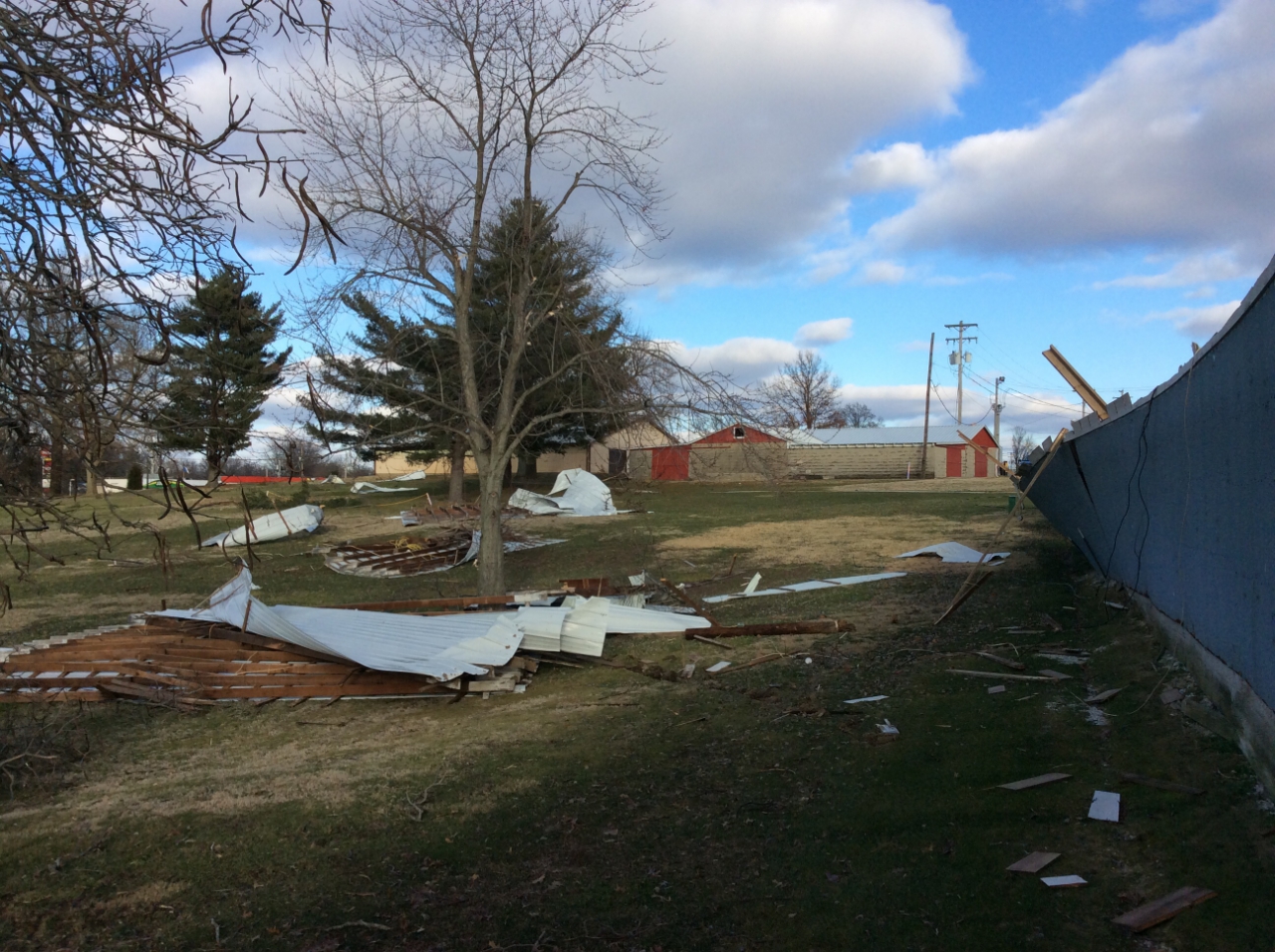
A line of thunderstorms developed early in the morning from western Arkansas into south central Missouri ahead of a strong cold front. This line of storms intensified as it moved east-northeast across the mid Mississippi Valley later in the morning. Some severe weather continued through the midday hours as the line progressed up the lower Ohio Valley. This line of storms was the final round of heavy rain, which capped a very wet couple days that resulted in storm totals of 2 to 4 inches. Isolated higher amounts up to near 5 inches were reported. Flooding was reported in many areas, especially southeast Missouri and southern Illinois.Tornadoes:
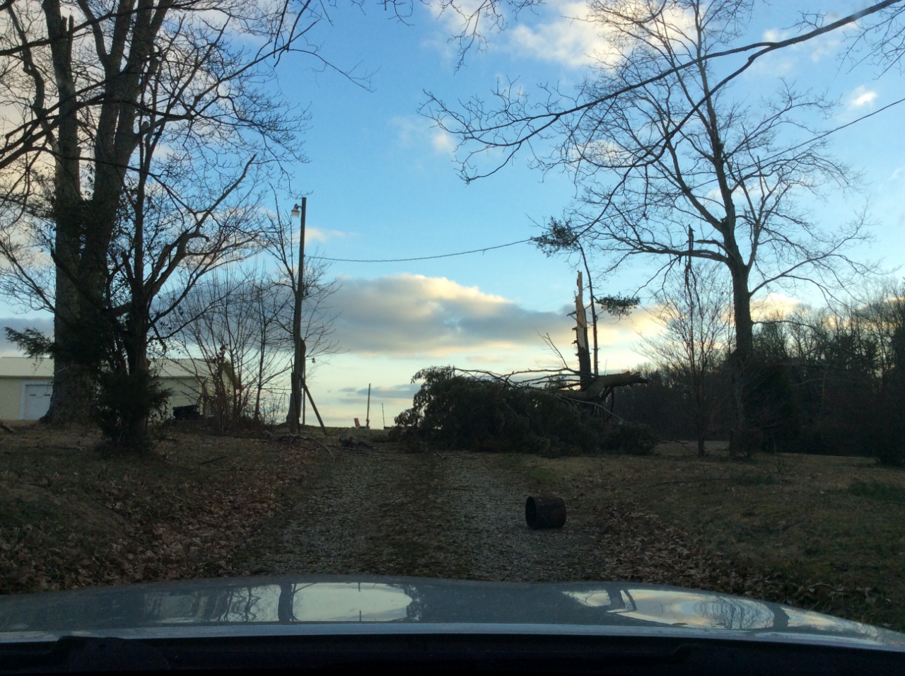
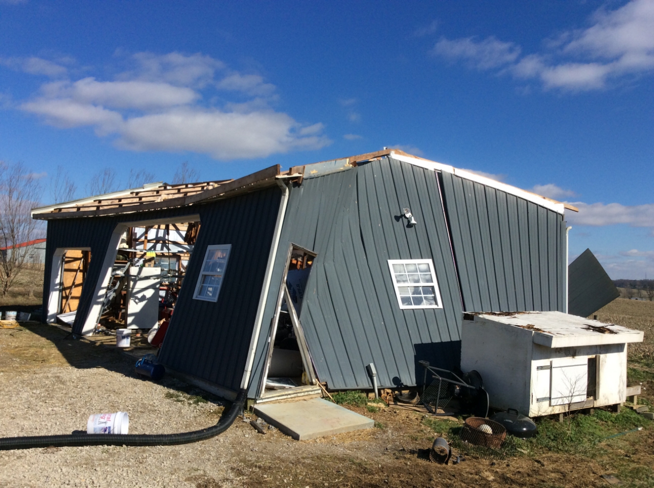
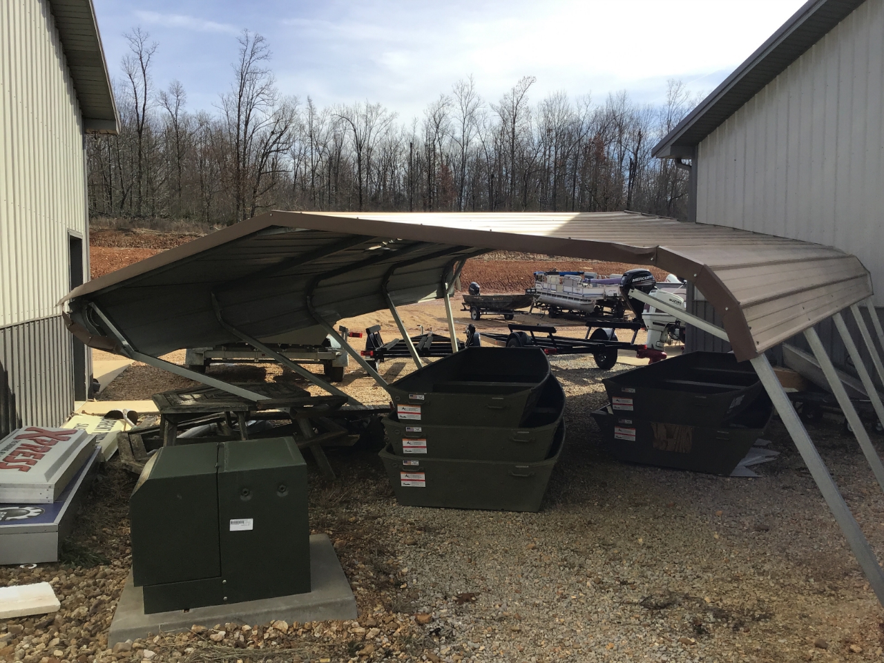
NWS damage survey teams found two EF-1 tornadoes, one in Henderson County, KY, near the community of Robards, and in Oakland City, IN, in Gibson County. Teams also surveyed damage in southeast Missouri and found straight-line thunderstorm wind damage in Dexter, southern Cape Girardeau County, and Piedmont.
|
|
||||||||||
|
||||||||||
|
Tornado #1 - Oakland City, Indiana
Track Map 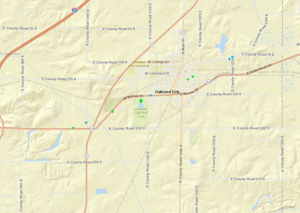 
|
||||||||||||||||
|
Tornado #2 - North of Robards, KY
Track Map 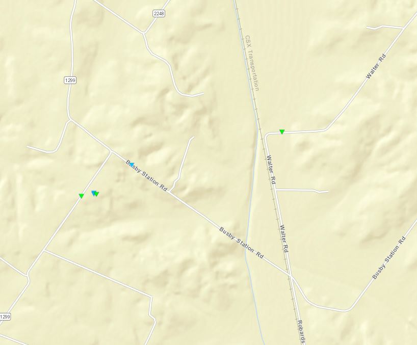
|
||||||||||||||||
The Enhanced Fujita (EF) Scale classifies tornadoes into the following categories:
| EF0 Weak 65-85 mph |
EF1 Moderate 86-110 mph |
EF2 Significant 111-135 mph |
EF3 Severe 136-165 mph |
EF4 Extreme 166-200 mph |
EF5 Catastrophic 200+ mph |
 |
|||||
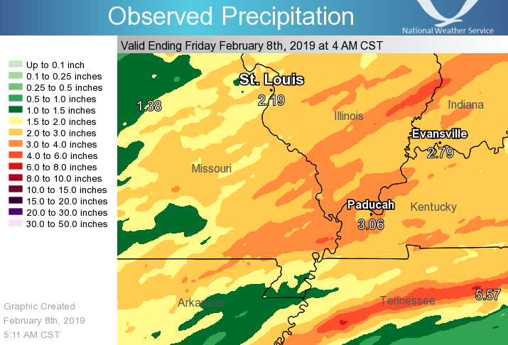
Flooding -
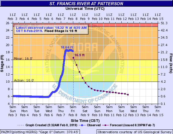
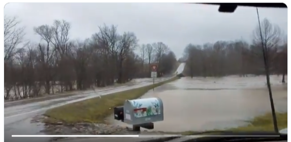
The cumulative effect of about 48 hours of showers and thunderstorms caused flooding of low-lying areas, especially in southern Illinois and southeast Missouri. Below is a storm total rainfall map, showing total rainfall for Feb. 6-7. Average amounts ranged from 2 to 4 inches, with isolated higher amounts. During the heaviest thunderstorms, there were local rainfall rates from one-half to one inch per hour.
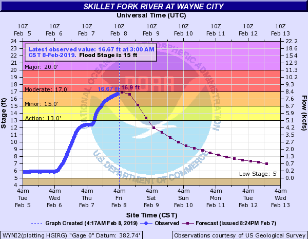
Hydrographs / Photos (click for full size)
 |
 |
 |
 |
| Skillet Fork near Wayne City, IL | St. Francis River near Patterson MO | Apple Creek south of Perryville, MO (Marc Kester) | Washed out County Road 925 North east of Fairfield, IL (WIFW/Derek Dunn) |
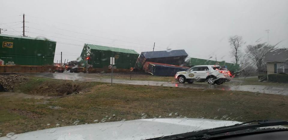
Photos (Click on photo for full size)
 |
 |
 |
 |
| Derailed train cars near Dexter MO (from Craig Meador) |
Overturned semi at Dexter, MO (from Craig Meador) |
Overturned rail cars at Dexter (Craig Meador) |
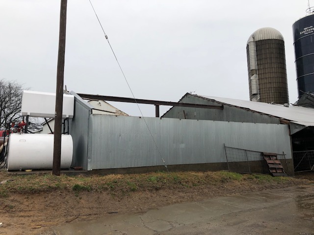
Damaged farm in Cape Girardeau Co. (Cape Co. Emergency Mngmt) |
 |
 |
 |
 |
| Damage in Oakland City, IN (NWS Damage Survey) |
Damage at golf course in Oakland City, IN (NWS Damage Survey) |
Damage at golf course in Oakland City, IN (NWS Damage Survey) |
Damage in Oakland City, IN (NWS Damage Survey) |
 |
 |
 |
 |
| Tornado damage near Robards, KY (NWS Damage Survey) |
Tornado damage near Robards, KY (NWS Damage Survey) |
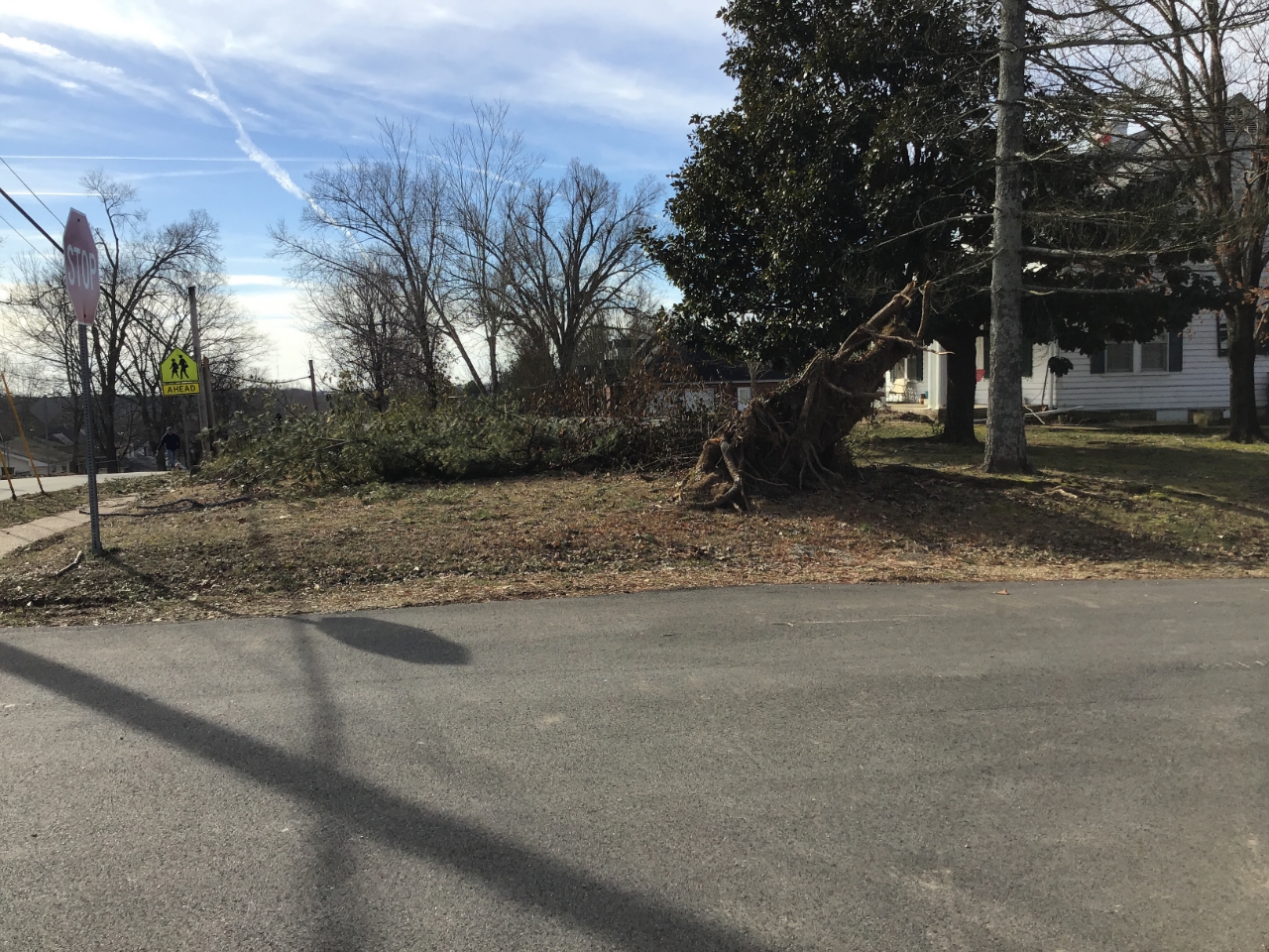
Straight-line wind damage to a boat shop near Piedmont, MO (NWS Damage Survey) |
Tree uprooted in Piedmont, MO (NWS Damage Survey) |
Storm Reports
PRELIMINARY LOCAL STORM REPORT...SUMMARY
NATIONAL WEATHER SERVICE PADUCAH KY
1206 AM CST FRI FEB 8 2019

..TIME...   ...EVENT...      ...CITY LOCATION...     ...LAT.LON...
..DATE...   ....MAG....      ..COUNTY LOCATION..ST.. ...SOURCE....
            ..REMARKS..

0750 AM     FLASH FLOOD      1 S VAN BUREN           37.00N 91.01W
02/07/2019                   CARTER             MO   EMERGENCY MNGR

            WATER RESCUES REPORTED AND WATER WAS
            REPORTED INSIDE OF THE FIRE DEPARTMENT IN
            VAN BUREN.

0808 AM     TSTM WND DMG     1 S DONIPHAN            36.60N 90.82W
02/07/2019                   RIPLEY             MO   FIRE DEPT/RESCUE

            SEVERAL BOATS AND TRAILERS WERE FLIPPED OVER
            AT A MARINE SHOP. GLASS DOORS WERE BLOWN OUT
            OF THE SHOP BUILDING. SEVERAL TREES WERE
            DOWN IN THE DONIPHAN AREA AS WELL AS A
            CARPORT THAT WAS BLOWN OVER.

0808 AM     Tstm Wnd Dmg     1 S Doniphan            36.61N 90.82W
02/07/2019                   Ripley             MO   NWS Storm Survey

            An NWS damage survey found scattered damage
            caused by straight-line thunderstorm winds.
            Estimated peak winds were 75 mph. The event
            began at 8:08 AM CST paralleling Missouri
            Highway 142 from 0.5 mile north of Doniphan,
            MO to 1 mile south of Doniphan, MO. The
            estimated path length was 1.5 miles, and the
            maximum width was 1.5 miles. Scattered tree
            damage across the Doniphan community,
            including a large pine that was uprooted. A
            carport was turned and damaged and several
            metal, flat-bottom fishing boats boats were
            overturned at a boat shop. A glass door was
            shattered at the boat shop. A power pole was
            snapped near a house that sustained light
            roof and fence damage.

0844 AM     HAIL             UNIONTOWN               37.62N 89.72W
02/07/2019  E1.50 INCH       PERRY              MO   BROADCAST MEDIA

            1 INCH TO 1.5 INCH HAIL REPORTED IN
            UNIONTOWN.

0852 AM     FLASH FLOOD      3 WSW WEST SALEM        38.50N 88.06W
02/07/2019                   EDWARDS            IL   TRAINED SPOTTER

            SPOTTER REPORTED AT LEAST AN INCH DEPTH OF
            WATER FLOWING OVER IL-130 IN 8 DIFFERENT
            AREAS BETWEEN BONE GAP AND PARKERSBURG.


0900 AM     Tstm Wnd Dmg     1 SW Dexter             36.78N 89.97W
02/07/2019                   Stoddard           MO   NWS Storm Survey

            An NWS storm survey found straight-line wind
            damage in Dexter, MO. Estimated peak winds
            were 90 mph. The damage started on the
            southwest side of Dexter and ended on the
            northeast side of Dexter. The event began at
            9:00 a.m. CST and ended at 9:05 a.m. CST.
            The path length was 3.1 miles and had a
            maximum width of 0.75 miles. Numerous trees
            were uprooted or snapped. Several homes
            sustained shingle loss or partial roof
            damage. A moving train carrying empty and
            full metal shipping containers was derailed.
            Several storage sheds at Busy Bees Lumbar
            were damaged. A couple businesses had large
            advertising signs blown down.

0900 AM     Tstm Wnd Dmg     2 S Whitewater          37.21N 89.80W
02/07/2019                   Cape Girardeau     MO   NWS Storm Survey

            An NWS damage survey found sporadic
            straight-line wind damage in the southern
            part of Cape Girardeau County, beginning two
            miles south of Whitewater, MO, and ending at
            Cape Girardeau, MO. Peak estimated winds
            were 80 mph. The event began at 9:00 a.m.
            CST and ended at 9:20 a.m. CST. The path
            length was 15 miles and had a maximum width
            of 1.5 miles. One open storage barn was
            destroyed, and other nearby barns sustained
            roof damage. A former school building
            received minor roof damage. A few homes
            sustained shingle and roof damage. Numerous
            trees were uprooted or snapped.

0901 AM     TSTM WND DMG     1 ENE DEXTER            36.80N 89.94W
02/07/2019                   STODDARD           MO   EMERGENCY MNGR

            A TRAIN WAS DERAILED DUE TO THUNDERSTORM
            WINDS.

0905 AM     TSTM WND DMG     1 W DEXTER              36.79N 89.97W
02/07/2019                   STODDARD           MO   PUBLIC


0912 AM     FLASH FLOOD      4 NW MOUNT CARMEL       38.47N 87.82W
02/07/2019                   WABASH             IL   PUBLIC

            0.80 INCHES OF RAIN REPORTED FROM THE STORM
            AND WATER BEGINNING TO FLOW OVER A
            NEIGHBORHOOD ROAD.

0914 AM     TSTM WND DMG     DUTCHTOWN               37.25N 89.66W
02/07/2019                   CAPE GIRARDEAU     MO   BROADCAST MEDIA

            ROOF AND TREE DAMAGE REPORTED.

0916 AM     TSTM WND DMG     1 NNW ZEIGLER           37.92N 89.06W
02/07/2019                   FRANKLIN           IL   BROADCAST MEDIA

            CAMPERS OVERTURNED AT LARRYS TRAILER SALES.

0945 AM     TSTM WND DMG     3 S PULASKI             37.17N 89.20W
02/07/2019                   PULASKI            IL   PUBLIC

            A TRAIN STRUCK A FALLEN TREE OVER THE
            RAILROAD TRACKS IN VILLA RIDGE IL.

1000 AM     FLOOD            1 ENE FAIRFIELD         38.38N 88.36W
02/07/2019                   WAYNE              IL   PUBLIC

            FLOODING ALONG NE 4TH STREET, HILL DRIVE,
            AND MILL STREET IN FAIRFIELD.

1001 AM     Tstm Wnd Dmg     1 NNE Springerton       38.19N 88.35W
02/07/2019                   White              IL   Emergency Mngr

            Delayed report. Front section of an old
            school building was knocked down by
            straight-line thunderstorm winds. Time
            estimated from radar.


1006 AM     FLOOD            3 WSW CARBONDALE        37.70N 89.27W
02/07/2019                   JACKSON            IL   TRAINED SPOTTER

            WATER OVER MCLAFFEE, PLEASANT HILL WEST, AND
            UNION HILL ROADS.

1013 AM     TSTM WND DMG     3 NE DUTCHTOWN          37.28N 89.62W
02/07/2019                   CAPE GIRARDEAU     MO   BROADCAST MEDIA

            TWO BARNS DESTROYED AND DOWNED POWER LINES
            REPORTED ALONG COUNTY ROAD 208.

1040 AM     TSTM WND DMG     4 NW PADUCAH            37.11N 88.69W
02/07/2019                   MCCRACKEN          KY   NEWSPAPER

            POWER LINES DOWN AT THE INTERSECTION OF
            SHAFFER ROAD AND NOBLE ROAD. TIME ESTIMATED
            FROM RADAR.

1046 AM     TSTM WND DMG     2 NE PADUCAH            37.09N 88.61W
02/07/2019                   MCCRACKEN          KY   NEWSPAPER

            POWER LINES DOWN NEAR THE INTERSECTION OF
            DR. MLK JR. DRIVE AND N. 11TH ST. TIME
            ESTIMATED FROM RADAR.


1054 AM     FLASH FLOOD      ANNA                    37.46N 89.24W
02/07/2019                   UNION              IL   911 CALL CENTER

            WATER COVERING LOW LYING PORTIONS OF E
            VIENNA STREET NEAR MCDONALDS.

1112 AM     Tornado          1.6 WSW Oakland City    38.33N 87.37W
02/07/2019                   Gibson             IN   NWS Storm Survey

            A NWS Damage Survey found Tornado damage
            with a peak intensity rating of EF-1. The
            tornado touched down 1.5 miles
            west-southwest of Oakland City, IN at 1112
            am CST and lifted 1.0 miles east-northeast
            of Oakland City, IN by 1116 am CST. Maximum
            estimated wind speed was 110 mph. The
            maximum path width was 100 yards. The path
            length of the tornado was 2.6 miles. A large
            metal storage building lost most of its roof
            at golf course. Several apartment buildings
            with significant roof damage with shingles
            removed. Self storage building near
            apartments had partial roof damage.
            Additional homes had minor shingle damage.
            Several large trees snapped and knocked
            down.


1116 AM     TSTM WND DMG     OAKLAND CITY            38.34N 87.35W
02/07/2019                   GIBSON             IN   EMERGENCY MNGR

            ROOFS OFF OF SEVERAL BUSINESS BUILDINGS,
            POWER POLES SNAPPED, SIGNIFICANT DAMAGE TO A
            STORAGE FACILITY OFF OF SR-57. POWER OUTAGES
            REPORTED ACROSS THE AREA.

1157 AM     Tornado          3.6 NW Robards          37.72N 87.58W
02/07/2019                   Henderson          KY   NWS Storm Survey

            A NWS Damage Survey found tornado damage
            with a peak intensity rating of EF-1. The
            tornado touched down 3.6 northwest of
            Robards, KY at 1157 am CST and lifted 3.6
            north-northwest of Robards, KY at 1159 am
            CST. The maximum estimated wind was 100 mph.
            the maximum path width was 30 yards. The
            path length of the tornado was 1.2 miles. A
            metal outbuilding completely lost its roof
            with walls partially collapsed. One large
            tree trunk snapped. Roofing material lofted
            quite a distance into trees. Other minor
            tree damage.

1205 PM     FLOOD            7 W EVANSVILLE          37.98N 87.68W
02/07/2019                   VANDERBURGH        IN   PUBLIC

            CORRECTS PREVIOUS FLASH FLOOD REPORT FROM 7
            W EVANSVILLE. OVERFLOWING BANKS AND WATER
            OVER THE ROAD NEAR CHAPEL HILL AND EICKHOFF
            RD.

1205 PM     FLASH FLOOD      7 W EVANSVILLE          37.98N 87.68W
02/07/2019                   VANDERBURGH        IN   PUBLIC

            OVERFLOWING BANKS AND WATER OVER THE ROAD
            NEAR CHAPEL HILL AND EICKHOFF RD.

1216 PM     FLOOD            1 ENE HARRISBURG        37.74N 88.54W
02/07/2019                   SALINE             IL   LAW ENFORCEMENT

            WATER ACROSS LOW LYING RURAL ROADS WEST OF
            CARRIER MILLS AND NORTH AND WEST OF
            HARRISBURG.

1232 PM     HEAVY RAIN       1 N DEXTER              36.80N 89.96W
02/07/2019  M4.23 INCH       STODDARD           MO   TRAINED SPOTTER

            24 HOUR MEASURED RAINFALL TOTAL.

1251 PM     HEAVY RAIN       5 N OXLY                36.67N 90.71W
02/07/2019  M3.10 INCH       RIPLEY             MO   TRAINED SPOTTER

            STORM TOTAL 3.10.


0622 PM     HEAVY RAIN       8 NW MURRAY             36.69N 88.42W
02/07/2019  M4.10 INCH       CALLOWAY           KY   TRAINED SPOTTER


0622 PM     HEAVY RAIN       1 SW CHICOPEE           36.97N 91.02W
02/07/2019  M2.44 INCH       CARTER             MO   MESONET

            MESONET STATION BGSM7, CHICOPEE MO.

0624 PM     HEAVY RAIN       4 E EVANSVILLE          37.98N 87.47W
02/07/2019  M2.90 INCH       VANDERBURGH        IN   TRAINED SPOTTER

            STORM TOTAL.

0625 PM     HEAVY RAIN       1.5 SW LONE OAK         37.02N 88.69W
02/07/2019  M3.59 INCH       MCCRACKEN          KY   NWS EMPLOYEE


0626 PM     HEAVY RAIN       FORT BRANCH             38.25N 87.57W
02/07/2019  M2.75 INCH       GIBSON             IN   TRAINED SPOTTER


0630 PM     HEAVY RAIN       5 NE WILSON CITY        36.97N 89.16W
02/07/2019  M3.50 INCH       MISSISSIPPI        MO   MESONET

            MESONET STATION BDPM7, 2 SE CAIRO.

0630 PM     HEAVY RAIN       1 WSW CHICOPEE          36.98N 91.02W
02/07/2019  M3.38 INCH       CARTER             MO   MESONET

            MESONET STATION VNBM7, CURRENT RIVER.

0630 PM     HEAVY RAIN       3 W FARIDEALING         36.85N 88.29W
02/07/2019  M3.18 INCH       MARSHALL           KY   MESONET

            MESONET STATION BENK2, BENTON.

0644 PM     HEAVY RAIN       4 NNW MURRAY            36.67N 88.33W
02/07/2019  M3.68 INCH       CALLOWAY           KY   MESONET

            MESONET STATION AP881, 4 NNW MURRAY.

0646 PM     HEAVY RAIN       RIDGWAY                 37.80N 88.26W
02/07/2019  M4.72 INCH       GALLATIN           IL   MESONET

            MESONET STATION E5011, RIDGWAY.

0646 PM     HEAVY RAIN       6 ENE HAZEL             36.54N 88.22W
02/07/2019  M3.60 INCH       CALLOWAY           KY   MESONET

            MESONET STATION F3304, 6 ENE HAZEL.

0646 PM     HEAVY RAIN       6 S WOLF ISLAND         36.66N 89.20W
02/07/2019  M3.12 INCH       MISSISSIPPI        MO   MESONET

            MESONET STATION E4994, 5 S WOLF ISLAND.

0646 PM     HEAVY RAIN       4 SE ALLEGRE            36.88N 87.17W
02/07/2019  M3.02 INCH       TODD               KY   MESONET

            MESONET STATION D3900, 4 SE ALLEGRE.

0647 PM     HEAVY RAIN       1 WNW SIKESTON          36.89N 89.60W
02/07/2019  M3.60 INCH       SCOTT              MO   MESONET

            MESONET STATION D1593, 1 WNW SIKESTON.

0650 PM     HEAVY RAIN       4 WSW CHRISTOPHER       37.96N 89.11W
02/07/2019  M2.69 INCH       FRANKLIN           IL   MESONET

            MESONET STATION D3094, 3 WSW CHRISTOPHER.

0655 PM     HEAVY RAIN       FAIRFIELD               38.38N 88.36W
02/07/2019  M4.28 INCH       WAYNE              IL   MESONET

            MESONET STATION E9367, FAIRFIELD.


0707 PM     HEAVY RAIN       2 W JACKSON             37.39N 89.69W
02/07/2019  M3.54 INCH       CAPE GIRARDEAU     MO   PUBLIC

            STORM TOTAL.


&&
.
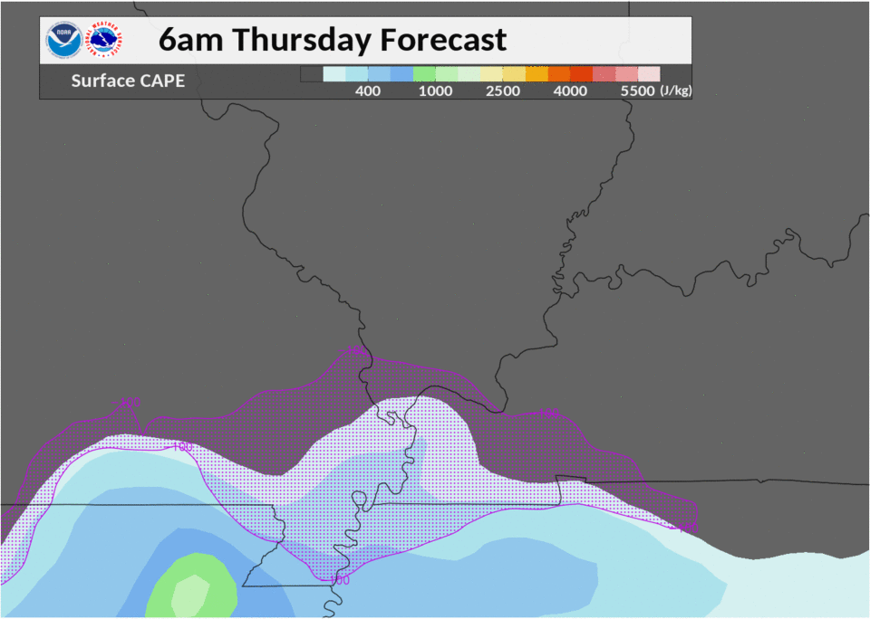
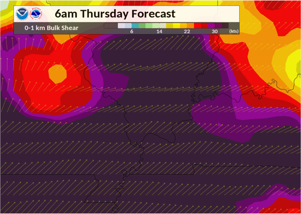
Environment
A strong cold front moved southeast across the region, accompanied by a line of thunderstorms.
Click on images for full size version.
Near-storm environment summary.
 |
 |
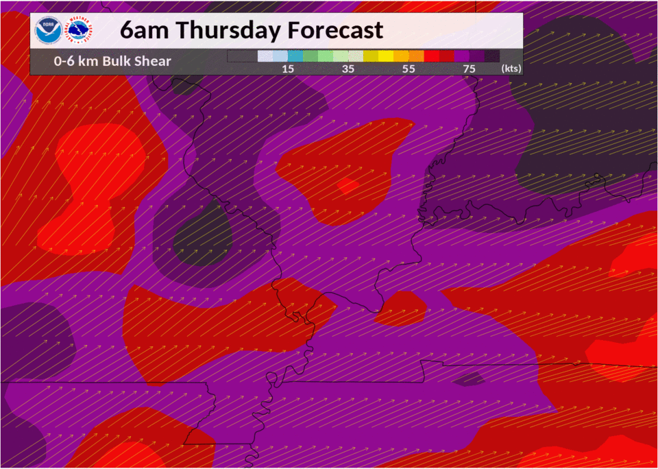 |
| Figure 4: surface CAPE/CIN | Figure 5: 0-1 km bulk shear | Figure 6: 0-6 km bulk shear |
 |
Media use of NWS Web News Stories is encouraged! Please acknowledge the NWS as the source of any news information accessed from this site. |
|

