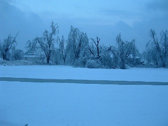
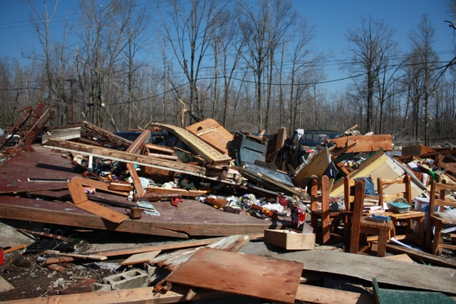
 1. Jan. 26 - 28 Ice Storm 1. Jan. 26 - 28 Ice Storm - What Kentucky Gov. Steve Beshear termed "the greatest natural disaster in modern Kentucky history" devastated trees and utility lines. At least fourteen lost lives were either directly or indirectly attributed to the storm. Preliminary damage estimates indicate this was the most damaging weather event since the modernized Paducah NWS office was opened in 1994. Additional photos available here. Photo taken at NWS Paducah. |
|
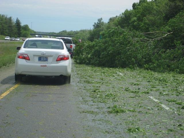 2. May 8 Windstorm - Widespread damaging winds from 70 to 90 mph, with pockets of winds up to 110 mph, raked a 20 to 30-mile wide corridor that included the Marion and Carbondale areas. Widespread power outages lasted for several days. The estimate of damaged structures in Williamson County alone exceeded 10,000. Photo taken on Interstate 57, courtesy of Stephen Hagan. 2. May 8 Windstorm - Widespread damaging winds from 70 to 90 mph, with pockets of winds up to 110 mph, raked a 20 to 30-mile wide corridor that included the Marion and Carbondale areas. Widespread power outages lasted for several days. The estimate of damaged structures in Williamson County alone exceeded 10,000. Photo taken on Interstate 57, courtesy of Stephen Hagan.
|
|
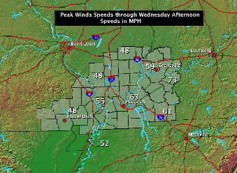 3. Feb. 11 High Winds - The strong winds brought down tree limbs and utility infrastructure already weakened by the historic January 27 ice storm. Power outages were reported in many places where power had been restored following the ice storm. Prior to the onset of high winds, power had not been restored to thousands of utility customers affected by the ice storm. 3. Feb. 11 High Winds - The strong winds brought down tree limbs and utility infrastructure already weakened by the historic January 27 ice storm. Power outages were reported in many places where power had been restored following the ice storm. Prior to the onset of high winds, power had not been restored to thousands of utility customers affected by the ice storm.
|
|
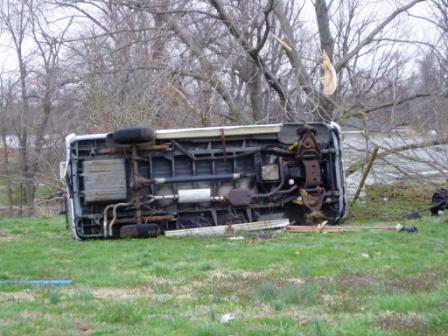 4. Mar. 28 EF-3 Tornado - A supercell produced baseball-size hail and tornadoes as it crossed Crittenden, Union, and Henderson Counties in west KY. The strongest tornado produced EF-3 damage in Henderson and Union Counties. There were no fatalities and just two injuries in this tornado, which was tied for the strongest tornado of the year in the NWS Paducah forecast area. NWS photo of an overturned vehicle. 4. Mar. 28 EF-3 Tornado - A supercell produced baseball-size hail and tornadoes as it crossed Crittenden, Union, and Henderson Counties in west KY. The strongest tornado produced EF-3 damage in Henderson and Union Counties. There were no fatalities and just two injuries in this tornado, which was tied for the strongest tornado of the year in the NWS Paducah forecast area. NWS photo of an overturned vehicle.
|
|
 5. Apr. 10 EF-3 Tornado - A severe weather outbreak during the midday hours of Apr. 10 was highlighted by one of the two strongest tornadoes of the year in the Paducah forecast area. The relatively short-track EF-3 tornado struck rural Christian County, KY, injuring two people. NWS photo of home blown off foundation in Christian County. 5. Apr. 10 EF-3 Tornado - A severe weather outbreak during the midday hours of Apr. 10 was highlighted by one of the two strongest tornadoes of the year in the Paducah forecast area. The relatively short-track EF-3 tornado struck rural Christian County, KY, injuring two people. NWS photo of home blown off foundation in Christian County.
|
|
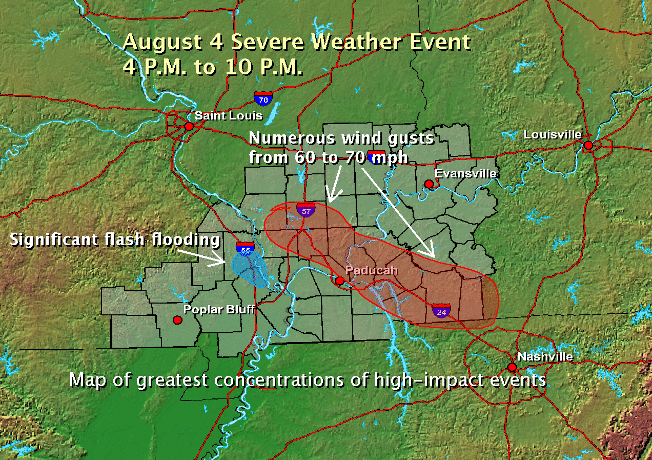 6. Aug. 4 Severe Storms - A complex of severe storms rapidly developed over southern IL and moved southeast across the Lakes region of West Kentucky. Over 30 reports of wind damage, funnel clouds, flash flooding, and hail were received by the Paducah NWS office in a 5-hour period ending at 9 P.M. Flash flooding occurred in Cape Girardeau, MO. 6. Aug. 4 Severe Storms - A complex of severe storms rapidly developed over southern IL and moved southeast across the Lakes region of West Kentucky. Over 30 reports of wind damage, funnel clouds, flash flooding, and hail were received by the Paducah NWS office in a 5-hour period ending at 9 P.M. Flash flooding occurred in Cape Girardeau, MO.
|
|
 7. Mar. 8 Tornadoes - Six tornado tracks were identified from the March 8 storms. The strongest tornado was rated EF-2 in Wayne County, IL, where one man was injured when his mobile home was rolled. The remainder of the tornadoes were rated EF-0 or EF-1 and caused no injuries or major damage to homes. NWS photo, taken in Wayne County, IL.WFO PAH Intranet | National Weather Service 7. Mar. 8 Tornadoes - Six tornado tracks were identified from the March 8 storms. The strongest tornado was rated EF-2 in Wayne County, IL, where one man was injured when his mobile home was rolled. The remainder of the tornadoes were rated EF-0 or EF-1 and caused no injuries or major damage to homes. NWS photo, taken in Wayne County, IL.WFO PAH Intranet | National Weather Service
|
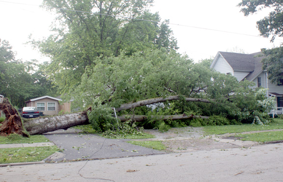 8. Jun. 8 Severe Storms - Two clusters of thunderstorms developed in the late afternoon, then tracked southeast across southern Illinois and southeast Missouri. The list of events included an EF-1 tornado, a few reports of quarter-size hail, and several damaging wind gusts from 60 to 70 mph. Photo taken in DuQuoin, IL courtesy of Jeff Profitt. 8. Jun. 8 Severe Storms - Two clusters of thunderstorms developed in the late afternoon, then tracked southeast across southern Illinois and southeast Missouri. The list of events included an EF-1 tornado, a few reports of quarter-size hail, and several damaging wind gusts from 60 to 70 mph. Photo taken in DuQuoin, IL courtesy of Jeff Profitt. |
|
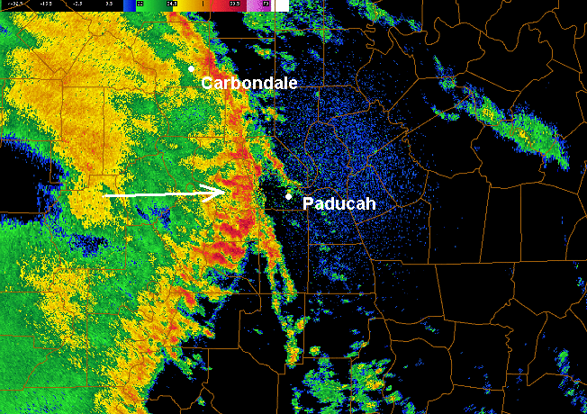 9. Apr. 9-10 Bow Echo - Preceding the April 10 daytime outbreak was a damaging wind event on the night of the 9th. A line of thunderstorms called a "bow echo" crossed southeast Missouri and much of western Kentucky, damaging some structures. A wind gust was clocked at 60 mph at the Paducah NWS office. 9. Apr. 9-10 Bow Echo - Preceding the April 10 daytime outbreak was a damaging wind event on the night of the 9th. A line of thunderstorms called a "bow echo" crossed southeast Missouri and much of western Kentucky, damaging some structures. A wind gust was clocked at 60 mph at the Paducah NWS office.
|
|
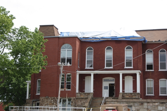 10. May 8 Ripley Co. Macroburst - Very damaging wind gusts up to 90 mph roared across Ripley County. The city of Doniphan was in the direct path of the storm and sustained major damage. This event was somewhat overshadowed by an even larger and more intense windstorm to the north (see event 2). NWS photo of the Ripley County courthouse. 10. May 8 Ripley Co. Macroburst - Very damaging wind gusts up to 90 mph roared across Ripley County. The city of Doniphan was in the direct path of the storm and sustained major damage. This event was somewhat overshadowed by an even larger and more intense windstorm to the north (see event 2). NWS photo of the Ripley County courthouse.
|
|
Have a safe and happy 2010!
|

