Top 10 Weather Headlines of 2008
2008 will be remembered for an extremely active late winter and early spring. From late January through mid-March, some type of very damaging weather event occurred almost weekly. Included during this period was widespread wind damage in late January, deadly tornadoes and a destructive ice storm in February, and historic flooding in March. The biggest snowstorm of the year waited until early March.
The following weather events are ranked unscientifically. The primary ranking factors are social impact (as measured by economic impact and loss of human life) and the extent of news media coverage. The meteorological rarity of the event is secondary.
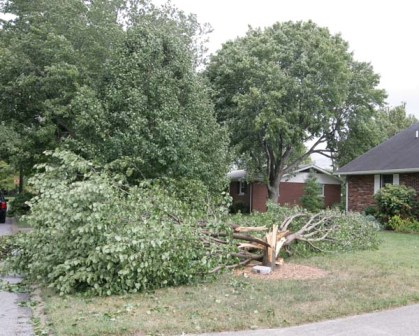 1. Remnants of Hurricane Ike - Sept. 14 - A preliminary damage estimate indicates this was the most damaging weather event since the modernized Paducah NWS office was opened in 1994. Over 200 million dollars damage and 40 to 50 injuries were caused by wind gusts commonly measured from 60 to 70 mph, with a few measured gusts around 75 mph. The effects included widespread power outages, hundreds of damaged buildings, and a large number of damaged boats and marinas. 1. Remnants of Hurricane Ike - Sept. 14 - A preliminary damage estimate indicates this was the most damaging weather event since the modernized Paducah NWS office was opened in 1994. Over 200 million dollars damage and 40 to 50 injuries were caused by wind gusts commonly measured from 60 to 70 mph, with a few measured gusts around 75 mph. The effects included widespread power outages, hundreds of damaged buildings, and a large number of damaged boats and marinas. |
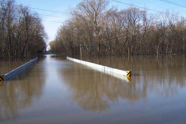 2. Historic Flooding on March 18-19 - Record-breaking rainfall in southeast Missouri contributed to widespread flooding. Over a foot of rain fell in Cape Girardeau in a 24 to 36-hour period. Dozens of flood victims were airlifted by Coast Guard helicopters. Record flooding of the Black River inundated large parts of Poplar Bluff. Three fatalities occurred in southern Illinois and southeast Missouri as people drove through flooded areas. 2. Historic Flooding on March 18-19 - Record-breaking rainfall in southeast Missouri contributed to widespread flooding. Over a foot of rain fell in Cape Girardeau in a 24 to 36-hour period. Dozens of flood victims were airlifted by Coast Guard helicopters. Record flooding of the Black River inundated large parts of Poplar Bluff. Three fatalities occurred in southern Illinois and southeast Missouri as people drove through flooded areas. |
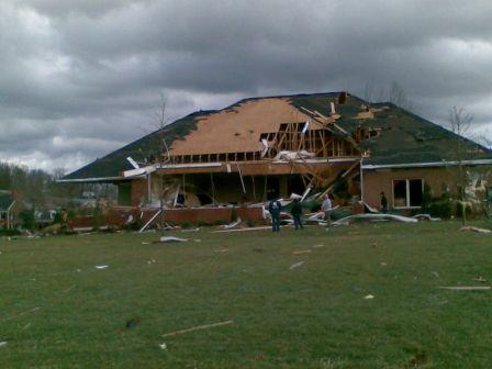 3. Deadly Tornadoes in West KY on Feb. 5 - A tornado rated EF-3 killed three people at a mobile home park in Muhlenberg County, KY. This tornado was the strongest of several in an outbreak that affected primarily western Kentucky. 3. Deadly Tornadoes in West KY on Feb. 5 - A tornado rated EF-3 killed three people at a mobile home park in Muhlenberg County, KY. This tornado was the strongest of several in an outbreak that affected primarily western Kentucky. |
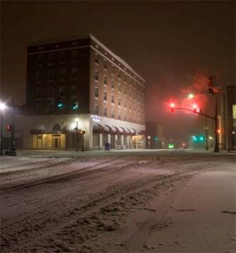
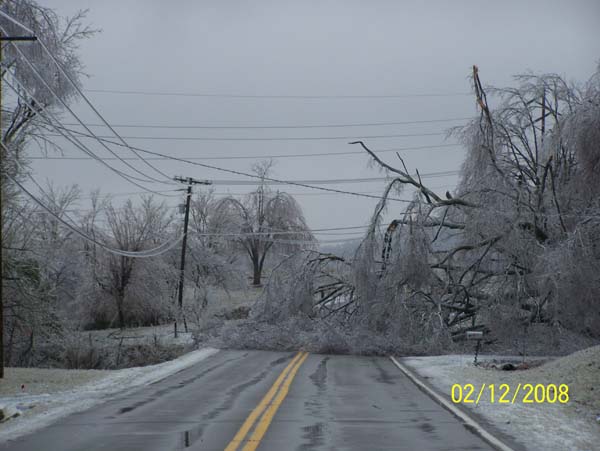 4. Major Ice Storm On Feb. 11 - Ice accumulations up to an inch thick brought down numerous trees and power lines from around Poplar Bluff, MO to Crittenden County, KY. National Guard personnel helped clear roads of downed trees. Power was out for three days or more in some places. 4. Major Ice Storm On Feb. 11 - Ice accumulations up to an inch thick brought down numerous trees and power lines from around Poplar Bluff, MO to Crittenden County, KY. National Guard personnel helped clear roads of downed trees. Power was out for three days or more in some places. |
| 5. Widespread Wind Damage/Tornadoes on Jan. 29 - A very strong cold front swept rapidly east, triggering a squall line that contained widespread damaging winds and an embedded deadly tornado. Two people were killed when an EF-2 tornado struck a mobile home in Posey County, IN. Another tornado occurred in Cape Girardeau County. At the Evansville airport, a wind gust was measured at 71 mph. Damage surveys indicated wind gusts of around 90 mph occurred in spots. |
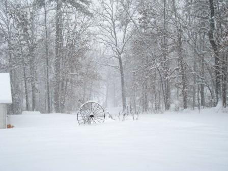
 6. March 7-8 Snowstorm - The biggest snowstorm of the winter waited until early March. This was the heaviest snowfall since the Christmas '04 storm at Evansville. Snowfall amounts varied anywhere from 2 to 10 inches. The highest amounts were over the Pennyrile region of west KY, where strong winds caused problems with drifting. 6. March 7-8 Snowstorm - The biggest snowstorm of the winter waited until early March. This was the heaviest snowfall since the Christmas '04 storm at Evansville. Snowfall amounts varied anywhere from 2 to 10 inches. The highest amounts were over the Pennyrile region of west KY, where strong winds caused problems with drifting. |
 7. March 3-4 Winter Storm and Flooding - On the warm side of the storm, 2 to 4 inches of rain fell across western Kentucky and southwest Indiana. On the cold side, the Ozark foothills of southeast Missouri received up to one foot of snow. In between, one-quarter to one-half inch of ice fell. 7. March 3-4 Winter Storm and Flooding - On the warm side of the storm, 2 to 4 inches of rain fell across western Kentucky and southwest Indiana. On the cold side, the Ozark foothills of southeast Missouri received up to one foot of snow. In between, one-quarter to one-half inch of ice fell. |
| 8. April 3 Flooding - More very heavy rain occurred over ground that was saturated from March flooding. Isolated locations received up to 6 inches of rain. Very localized evacuations were conducted. Flooding of roads was the main problem. |
.png) 9. Snowstorm on Jan. 31 - This snowstorm was mainly along and northwest of a line from Cape Girardeau, MO to Carbondale, IL. Four to six inches of snow fell across that region. (Map of snowfall at left, click for full size). 9. Snowstorm on Jan. 31 - This snowstorm was mainly along and northwest of a line from Cape Girardeau, MO to Carbondale, IL. Four to six inches of snow fell across that region. (Map of snowfall at left, click for full size). |
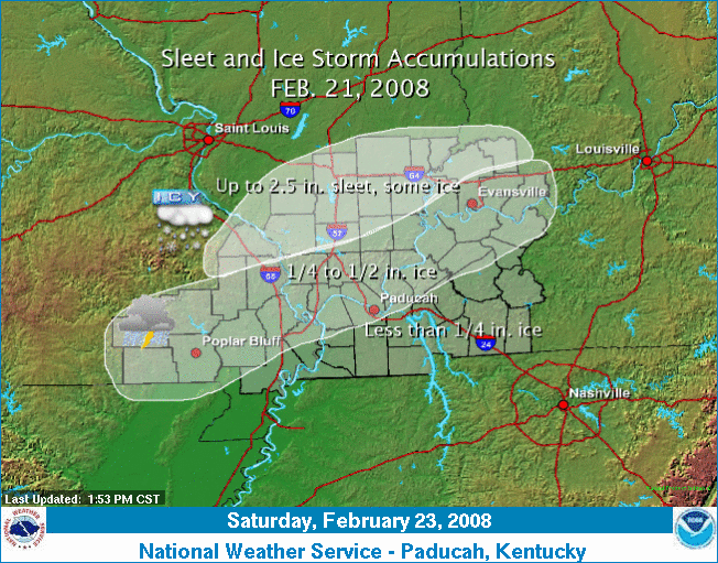 10. Feb. 21 Ice Storm - Another ice storm occurred on the heels of the Feb. 11 ice storm. This ice storm did not rival the severity of its predecessor. Ice accumulations were mostly one-half inch or less. Thunder was reported with the sleet and freezing rain in some places. A rash of accidents occurred at the beginning of the freezing rain. 10. Feb. 21 Ice Storm - Another ice storm occurred on the heels of the Feb. 11 ice storm. This ice storm did not rival the severity of its predecessor. Ice accumulations were mostly one-half inch or less. Thunder was reported with the sleet and freezing rain in some places. A rash of accidents occurred at the beginning of the freezing rain. |
|
Have a safe and happy 2009! |

