Top 10 Weather Headlines of 2001
Unlike the past couple of years, the year 2001 lacked an obvious number one choice. In 1999, a severe summer drought wreaked hundreds of millions of dollars in crop damage. In 2000, devastating F-3 tornadoes struck the city of Owensboro, Kentucky, and rural Crittenden County, Kentucky, causing nearly 100 million dollars in damage. Although 2001 had its share of destructive weather, no single event caused more than 10 million dollars damage. The 2001 spring severe weather season was relatively quiet, as was the winter weather season. It was during the last few months of the year that severe thunderstorms, tornadoes, and floods made their mark.
The following list is highly subjective. The rankings below are based mostly on damage figures and injury counts.
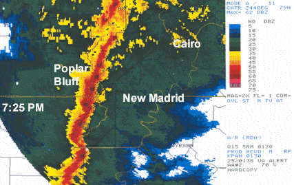
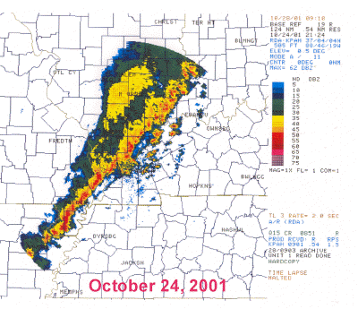 1. October 24 - Damaging thunderstorm winds caused about 1.5 million dollars in damage across the region. At least 16 persons were injured. The bulk of the damage and injuries were north of a line from Cape Girardeau, Missouri to Evansville, Indiana. A few weak tornadoes were confirmed. Damage surveys revealed that several of the microbursts and tornadoes contained wind speeds in the 80 to 100 MPH range. 1. October 24 - Damaging thunderstorm winds caused about 1.5 million dollars in damage across the region. At least 16 persons were injured. The bulk of the damage and injuries were north of a line from Cape Girardeau, Missouri to Evansville, Indiana. A few weak tornadoes were confirmed. Damage surveys revealed that several of the microbursts and tornadoes contained wind speeds in the 80 to 100 MPH range. |
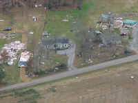 2 . November 24 - A tornado struck Calloway County, Kentucky just before 7 A.M. The F-2 tornado produced a path of damage 11 miles long and nearly 300 yards wide. A total of 45 to 50 structures were damaged or destroyed. The community of Harris Grove was directly hit. Numerous farms in rural areas west of Murray were struck. Several persons were injured, and initial damage estimates were over one-half million dollars. 2 . November 24 - A tornado struck Calloway County, Kentucky just before 7 A.M. The F-2 tornado produced a path of damage 11 miles long and nearly 300 yards wide. A total of 45 to 50 structures were damaged or destroyed. The community of Harris Grove was directly hit. Numerous farms in rural areas west of Murray were struck. Several persons were injured, and initial damage estimates were over one-half million dollars. |
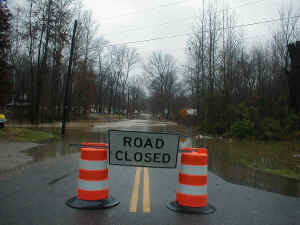 3. Nov. 28 - Dec. 17 - Flooding was commonplace across western Kentucky in late November. Particularly hard-hit was the area from Murray to Hopkinsville, where the Little River and the Clarks River inundated many roads. More heavy rain in mid December caused significant flooding across southern Illinois, southeast Missouri, and southwest Indiana. Rainfall totals for the 3 to 4-week period were commonly from 10 to 15 inches. 3. Nov. 28 - Dec. 17 - Flooding was commonplace across western Kentucky in late November. Particularly hard-hit was the area from Murray to Hopkinsville, where the Little River and the Clarks River inundated many roads. More heavy rain in mid December caused significant flooding across southern Illinois, southeast Missouri, and southwest Indiana. Rainfall totals for the 3 to 4-week period were commonly from 10 to 15 inches. |
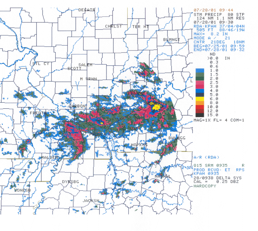 4. July 19 - July 29 - Flash flooding. Tropical humidity, combined with very weak winds aloft, led to day after day of slow-moving thunderstorm complexes in July. Although the rainfall was much-needed, copious amounts fell in short amounts of time, leading to localized flash flooding. The areas that were hard hit included Murray, Kentucky, Cape Girardeau, Missouri, and Livingston County, Kentucky. (Image at left is a radar-estimated rainfall map. Click on it for full size or follow the link above). 4. July 19 - July 29 - Flash flooding. Tropical humidity, combined with very weak winds aloft, led to day after day of slow-moving thunderstorm complexes in July. Although the rainfall was much-needed, copious amounts fell in short amounts of time, leading to localized flash flooding. The areas that were hard hit included Murray, Kentucky, Cape Girardeau, Missouri, and Livingston County, Kentucky. (Image at left is a radar-estimated rainfall map. Click on it for full size or follow the link above). |
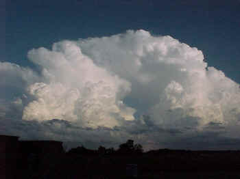 5. Sept. 6 - Sept. 8 - Each afternoon and evening from September 6 to 8, thunderstorms produced isolated pockets of wind damage. On September 6, the damage occurred in Grandview, Indiana and southwest Calloway County, KY. On September 7, major structural damage occurred in Shawneetown, Illinois and southwest Caldwell County, KY. (Photo at left was taken from the Paducah NWS office on Sept. 8). 5. Sept. 6 - Sept. 8 - Each afternoon and evening from September 6 to 8, thunderstorms produced isolated pockets of wind damage. On September 6, the damage occurred in Grandview, Indiana and southwest Calloway County, KY. On September 7, major structural damage occurred in Shawneetown, Illinois and southwest Caldwell County, KY. (Photo at left was taken from the Paducah NWS office on Sept. 8). |
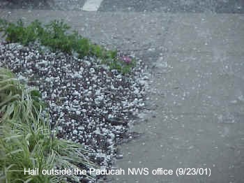 6. Sept. 23 - Hailstorms struck parts of west Kentucky and extreme southeast Missouri during the late afternoon hours. Half-dollar size hail fell at Paducah and Princeton, KY. Strong winds up to 65 MPH accompanied a few of the storms. (Photo at left was taken at the Paducah NWS Office on Sept. 23). 6. Sept. 23 - Hailstorms struck parts of west Kentucky and extreme southeast Missouri during the late afternoon hours. Half-dollar size hail fell at Paducah and Princeton, KY. Strong winds up to 65 MPH accompanied a few of the storms. (Photo at left was taken at the Paducah NWS Office on Sept. 23). |
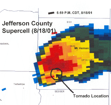 7. August 18 - A supercell thunderstorm crossed Jefferson County, Illinois during the late afternoon. The storm produced golf-ball size hail, a weak tornado, and damaging straight-line winds. The storm displayed the classic radar signatures of a rotating supercell. Structural damage was confined to rural areas southwest of Mount Vernon. 7. August 18 - A supercell thunderstorm crossed Jefferson County, Illinois during the late afternoon. The storm produced golf-ball size hail, a weak tornado, and damaging straight-line winds. The storm displayed the classic radar signatures of a rotating supercell. Structural damage was confined to rural areas southwest of Mount Vernon. |
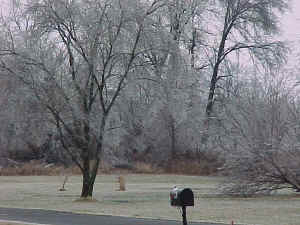 8. February 21 - A sleet and ice storm, accompanied by thunder and lightning, occurred during the evening hours. Around 1/4 inch of ice coated trees and power lines across much of southeast Missouri and western Kentucky. Sleet and snow was the main precipitation type over southern Illinois and southwest Indiana. Mainly rain fell closest to the Tennessee border. (Photo at left taken at the Paducah NWS office). 8. February 21 - A sleet and ice storm, accompanied by thunder and lightning, occurred during the evening hours. Around 1/4 inch of ice coated trees and power lines across much of southeast Missouri and western Kentucky. Sleet and snow was the main precipitation type over southern Illinois and southwest Indiana. Mainly rain fell closest to the Tennessee border. (Photo at left taken at the Paducah NWS office). |
 9. February 24 - Strong winds, gusting up to 60 MPH in a few spots, occurred during the evening hours. Some of the strong wind gusts were not related to thunderstorms. An intense low pressure system over the Plains states produced strong winds well outside of any thunderstorms. Some tree and power line damage occurred. There was no major structural damage or injuries. 9. February 24 - Strong winds, gusting up to 60 MPH in a few spots, occurred during the evening hours. Some of the strong wind gusts were not related to thunderstorms. An intense low pressure system over the Plains states produced strong winds well outside of any thunderstorms. Some tree and power line damage occurred. There was no major structural damage or injuries. |
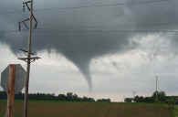 10. May 31 - A weak tornado briefly touched down near Pinckneyville, Illinois during the late afternoon hours. A unique aspect of this tornado was that it was well documented, with numerous photos and videos taken. The tornado was also unique in that it was not associated with commonly observed radar characteristics, such as a heavy rain or hail shaft. No damage was known to have occurred with this tornado. 10. May 31 - A weak tornado briefly touched down near Pinckneyville, Illinois during the late afternoon hours. A unique aspect of this tornado was that it was well documented, with numerous photos and videos taken. The tornado was also unique in that it was not associated with commonly observed radar characteristics, such as a heavy rain or hail shaft. No damage was known to have occurred with this tornado. |
|
Have a safe and happy 2002! |

