Top 10 Weather Headlines of 2000
 1. January 3: The year began on a very destructive note, with a powerful F-3 tornado directly hitting Owensboro, KY. Another F-3 tornado struck a small community in Crittenden County, KY. The two tornadoes caused nearly 80 million dollars damage and dozens of injuries. 1. January 3: The year began on a very destructive note, with a powerful F-3 tornado directly hitting Owensboro, KY. Another F-3 tornado struck a small community in Crittenden County, KY. The two tornadoes caused nearly 80 million dollars damage and dozens of injuries. |
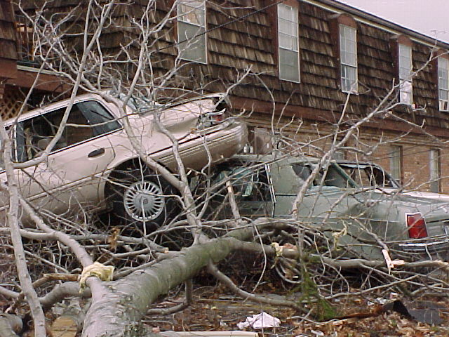
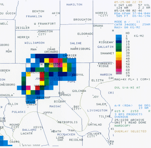 2 . Hailstorms on May 23: The spring severe weather season, which had been unusually quiet, suddenly became much more active during the last week of May. Violent supercell thunderstorms erupted during the afternoon of May 23, spawning a few tornadoes and lots of hail. Hailstorms struck a number of communities. One of the worst occurred during the late evening hours of May 23, when baseball size hail caused extensive damage in much of Johnson County, Illinois. The town of Vienna sustained extensive damage. 2 . Hailstorms on May 23: The spring severe weather season, which had been unusually quiet, suddenly became much more active during the last week of May. Violent supercell thunderstorms erupted during the afternoon of May 23, spawning a few tornadoes and lots of hail. Hailstorms struck a number of communities. One of the worst occurred during the late evening hours of May 23, when baseball size hail caused extensive damage in much of Johnson County, Illinois. The town of Vienna sustained extensive damage. |
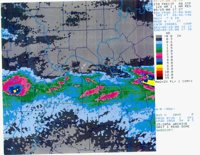 3. May 24 Flash Flooding and Severe Storms: 3. May 24 Flash Flooding and Severe Storms:
A series of severe weather outbreaks occurred during the last week of May. On May 24, most of the storms were concentrated near the Tennessee and Arkansas borders. Flash flooding and wind damage were the primary events, mainly from west of Poplar Bluff, MO. to Hopkinsville, KY. |
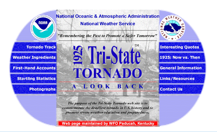 4. The 75th Anniversary of the Tri-State Tornado: The Paducah National Weather Service, in cooperation with several state and local organizations, organized a special observance of the Great Tri-State Tornado of March, 1925. This tornado was the deadliest to ever strike the United States. Its path was directly across northern portions of the Paducah National Weather Service forecast area. The city of Murphysboro, Illinois, near Carbondale, was devastated. Hundreds of lives were lost. 4. The 75th Anniversary of the Tri-State Tornado: The Paducah National Weather Service, in cooperation with several state and local organizations, organized a special observance of the Great Tri-State Tornado of March, 1925. This tornado was the deadliest to ever strike the United States. Its path was directly across northern portions of the Paducah National Weather Service forecast area. The city of Murphysboro, Illinois, near Carbondale, was devastated. Hundreds of lives were lost. |
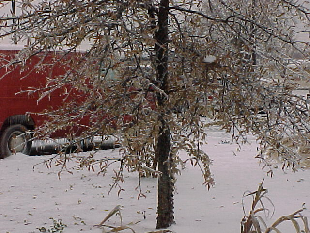 5. Winter Storm of December 13: Heavy snow and ice accumulations caused scattered power outages and major transportation problems. Snowfall across parts of southern Illlinois and southeast Missouri was near 7 inches, while further southeast, ice was a big problem in parts of western Kentucky and southwest Indiana. About one half inch of ice glazed trees, power lines, and roads. 5. Winter Storm of December 13: Heavy snow and ice accumulations caused scattered power outages and major transportation problems. Snowfall across parts of southern Illlinois and southeast Missouri was near 7 inches, while further southeast, ice was a big problem in parts of western Kentucky and southwest Indiana. About one half inch of ice glazed trees, power lines, and roads. |
 6. Record Cold in December: Evansville recorded its second coldest December in over 100 years of records. Paducah recorded its coldest on record. There was above normal snowfall to accompany the cold. Evansville and Paducah both recorded December monthly snowfalls that ranked in the top three. 6. Record Cold in December: Evansville recorded its second coldest December in over 100 years of records. Paducah recorded its coldest on record. There was above normal snowfall to accompany the cold. Evansville and Paducah both recorded December monthly snowfalls that ranked in the top three. |
 7. Flooding over southeast Missouri and southern Illinois on June 16: Up to 10 inches of rain fell within a three-day period over the Carbondale, Illinois area. Significant flooding occurred from around Marble Hill, Missouri, eastward across the Marion and Carbondale areas. 7. Flooding over southeast Missouri and southern Illinois on June 16: Up to 10 inches of rain fell within a three-day period over the Carbondale, Illinois area. Significant flooding occurred from around Marble Hill, Missouri, eastward across the Marion and Carbondale areas. |
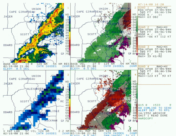 8. Cairo Downburst on February 18: A short-lived but very intense thunderstorm microburst caused about a half million dollars damage in the center of Cairo, IL. The affected area was about 5 city blocks wide and a mile long. A total of 52 buildings were damaged or destroyed. Five residences were moved off their foundations and considered total losses. The other 47 buildings sustained varying degrees of damage, mainly to windows and roofs. 8. Cairo Downburst on February 18: A short-lived but very intense thunderstorm microburst caused about a half million dollars damage in the center of Cairo, IL. The affected area was about 5 city blocks wide and a mile long. A total of 52 buildings were damaged or destroyed. Five residences were moved off their foundations and considered total losses. The other 47 buildings sustained varying degrees of damage, mainly to windows and roofs. |
 9. April 16 Severe Storms in SE Missouri and West Kentucky: A supercell thunderstorm developed near Zalma in Bollinger County, MO, late in the afternoon. This storm produced hail up to baseball size. The storm produced a funnel cloud over extreme northeast Stoddard County. The storms increased in coverage over Scott County, MO, but weakened somewhat. After dark, the storms then reintensified as they crossed the Mississippi River near Cairo. Large hail, ranging from quarter up to golf ball size, was reported from the Cairo area east to near Paducah. 9. April 16 Severe Storms in SE Missouri and West Kentucky: A supercell thunderstorm developed near Zalma in Bollinger County, MO, late in the afternoon. This storm produced hail up to baseball size. The storm produced a funnel cloud over extreme northeast Stoddard County. The storms increased in coverage over Scott County, MO, but weakened somewhat. After dark, the storms then reintensified as they crossed the Mississippi River near Cairo. Large hail, ranging from quarter up to golf ball size, was reported from the Cairo area east to near Paducah. |
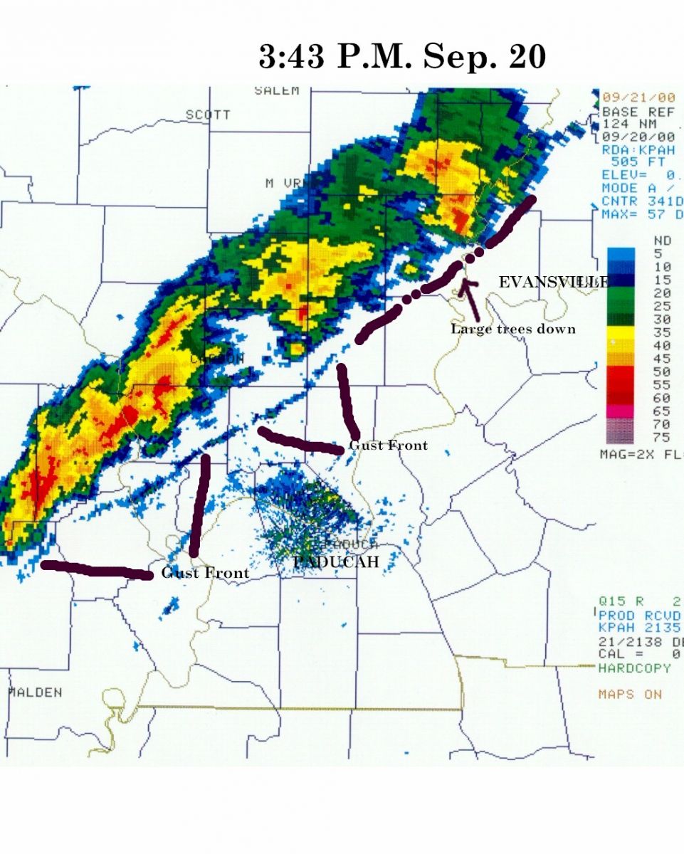 10. Thunderstorm Gust Front on September 20: A large area of thunderstorms produced an organized squall line that raked much of the Lower Ohio Valley with winds between 50 and 65 MPH. 10. Thunderstorm Gust Front on September 20: A large area of thunderstorms produced an organized squall line that raked much of the Lower Ohio Valley with winds between 50 and 65 MPH. |
|
Have a safe and happy 2001! |

