Spring 2024 Climate Summary:
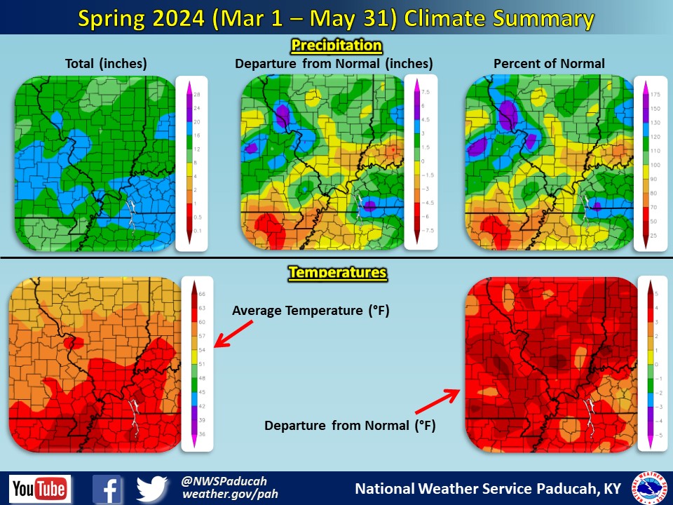
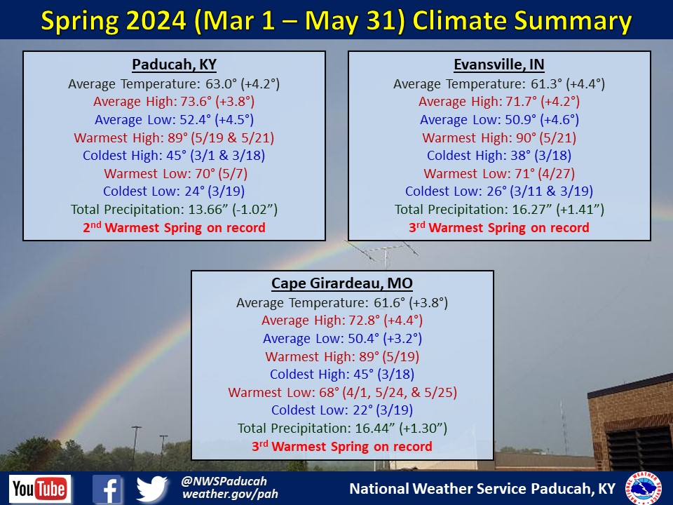
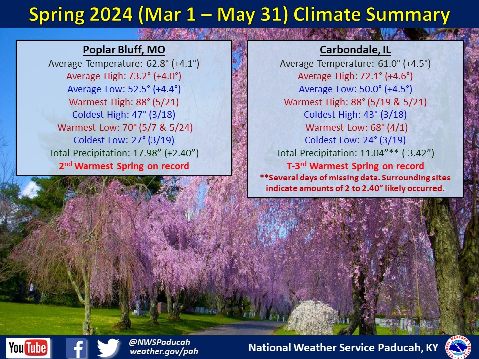
Similar to winter, spring temperatures were well above normal by 3 to 5 degrees. Paducah and Poplar Bluff finished with their 2nd warmest spring while Evansville, Cape Girardeau, and Carbondale finished in at least a share of 3rd warmest. Each month this spring was well above normal. March was 5 to 6 degrees above normal, April was 3 to 4 degrees above normal, and May was 3 to 5 degrees above normal. Record highs were set for at least 1 of the 5 climate sites on March 4th and 5th along with April 15th. Notably, Paducah set their record for warmest average low temperature for spring. Despite a sharp lean towards above normal temperatures, a few cold periods occurred, resulting in freeze conditions April 6th, and some frost development April 22nd.
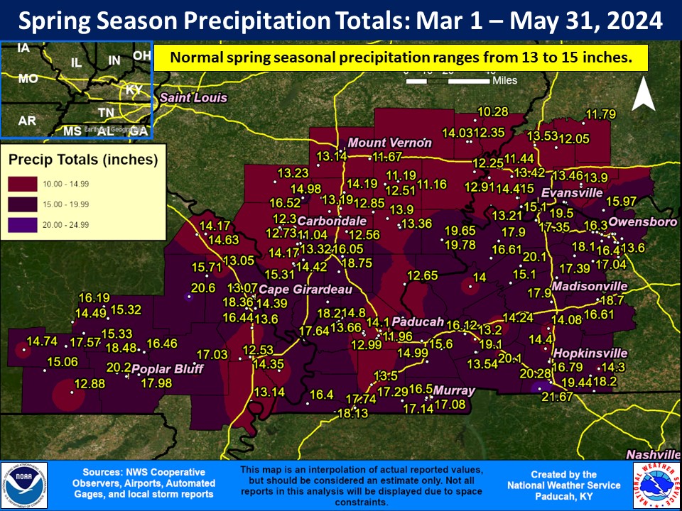
With a wild ride to get there, many locations across the Quad State finished spring near normal for precipitation. Areas near the I-64 corridor were below normal with 10 to 13’’. Much of Western Kentucky, and portions of Southern Illinois and Southeast Missouri finished wetter than normal with 15 to 20’’ and a few locally higher amounts. March was well below normal across most of the Quad State, ranging from 1 to 4’’. April was near normal, ranging from 2.5 to 6.5’’. May was well above normal in many areas, ranging from 4 to 15’’. The highest reported amount was 22.58” at a CoCoRaHS station 3.8 miles northeast of Goreville, IL. Areas with the higher rainfall totals included the southern Pennyrile near the Tennessee border, a line from around Harrisburg, IL to Owensboro, KY, Butler County, MO, and portions of far Southern Illinois.
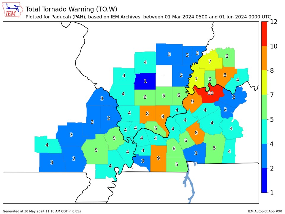
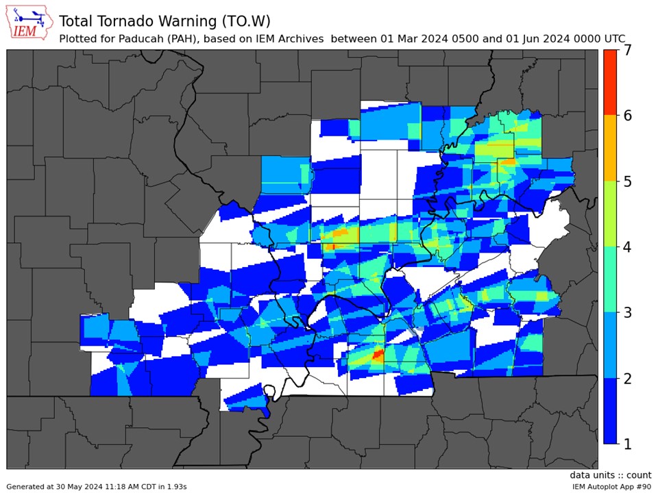
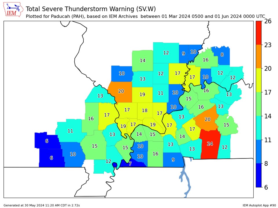
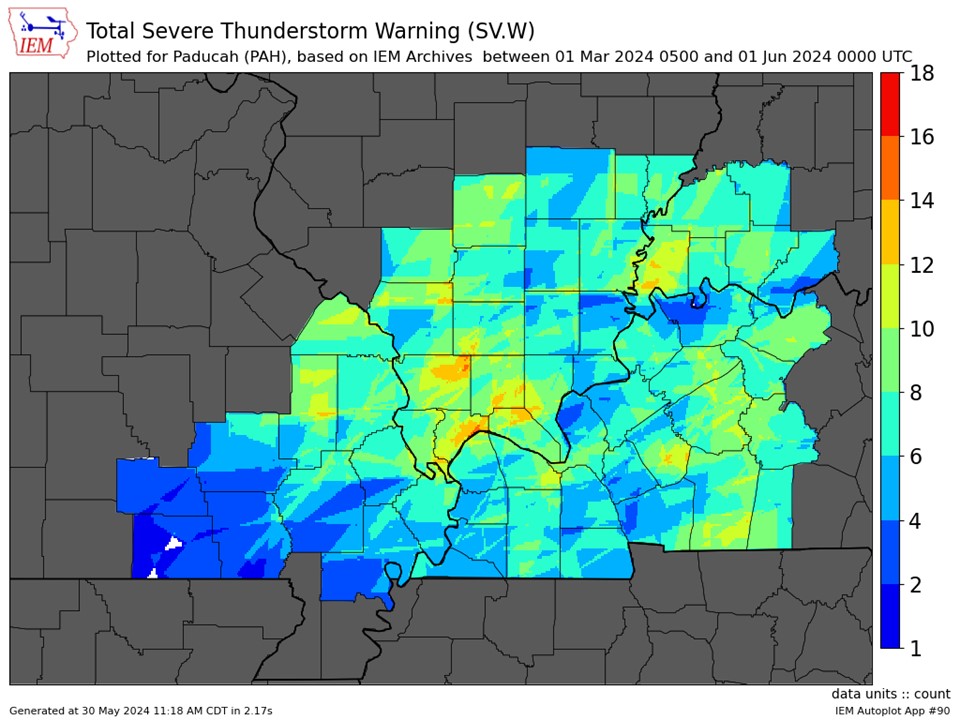
Three especially notable severe weather events occurred this spring. The April 2nd early morning tornado outbreak included 19 tornadoes, the most tornadoes in a single day for the Quad State region since Halloween 2013. The May 8th multi-round severe weather outbreak included 9 tornadoes and set the office record for most warnings (SVR, TOR, FFW) issued in a single day. The May 26th multi-round severe weather outbreak included widespread straight-line wind damage along with 14 tornadoes (as of this writing), and the second highest single day warning issuance count.
The graphic below is an interpolated rainfall map using actual observations. Please note that there are likely discrepancies in between observations, since the values are estimated based on nearest reports.
|
Spring 2024 Review: Precipitation and Temperature Maps (Click on image to enlarge) |
 |
| Climate Maps are from the Northeast Regional Climate Center |
| Severe Thunderstorm Warnings - County Based | Severe Thunderstorm Warnings - Polygon Based |
 |
 |
| Tornado Warnings - County Based | Tornado Warnings - Polygon Based |
|
|
|