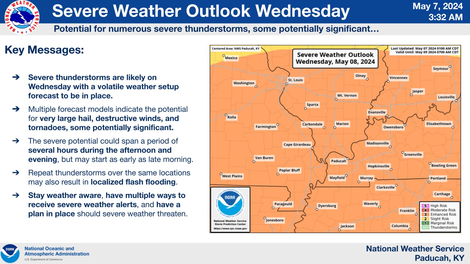
Overview
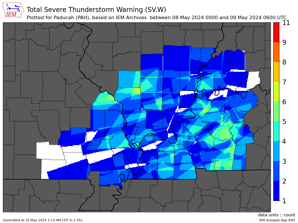
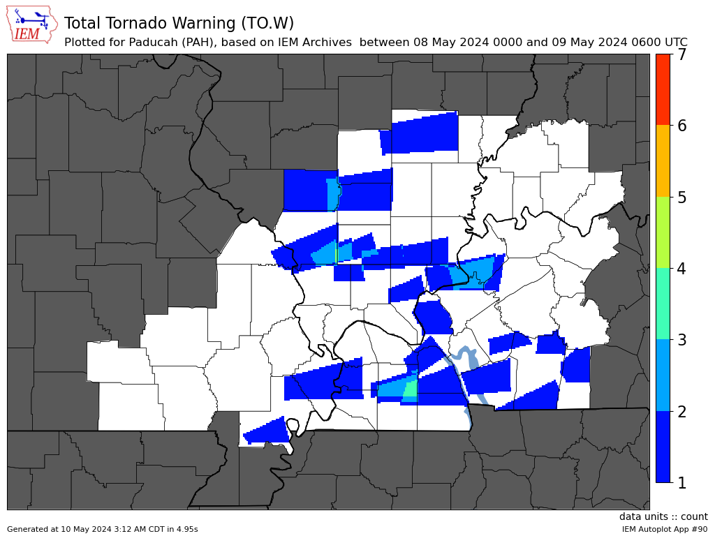
Multiple rounds of severe thunderstorms impacted the Quad-state region on May 8, 2024. The first round actually started during the late evening of May 7th and continued into the overnight and morning of the 8th. The most widespread and significant storms occurred during the afternoon and evening of the 8th. Storm mode was largely supercells or bowing segments. Damaging winds in excess of 70 mph and golf ball sized hail occurred with some of the stronger storms. At least 9 tornadoes have been confirmed so far. Multiple storms training over the same location resulted in flash flooding with rainfall amounts exceeding 2 to 4 inches in some communities, and locally 5 to 6 inches.Tornadoes:
Additional damage surveys will continue in the coming days so stay tuned for updates!
|
Tornado #1 - Cora, Illinois
|
||||||||||||||||
|
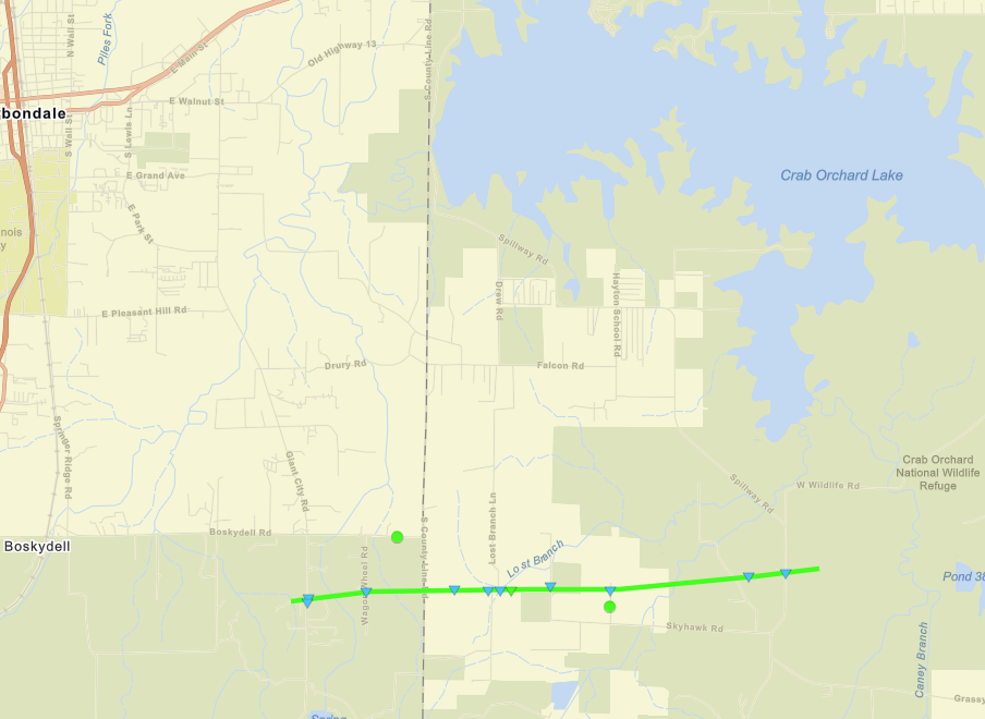
Tornado #2 - Crab Orchard Lake, Illinois
|
||||||||||||||||
|
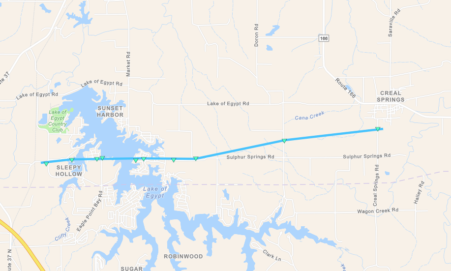
Tornado #3 - Lake of Egypt, Illinois
|
||||||||||||||||
|
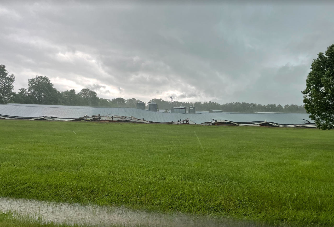
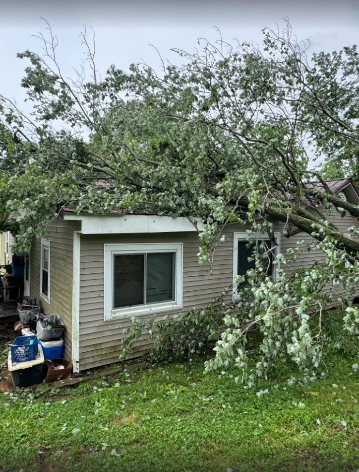
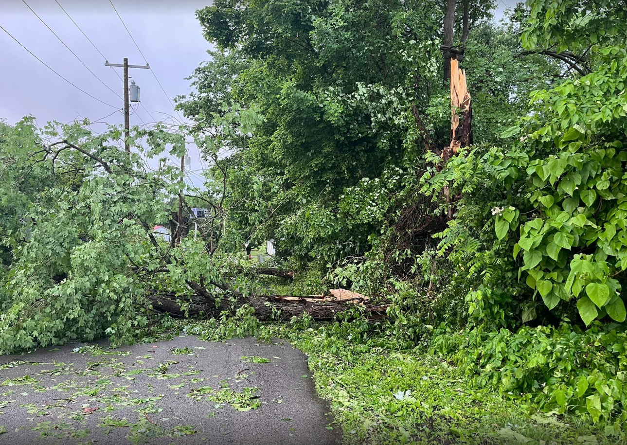
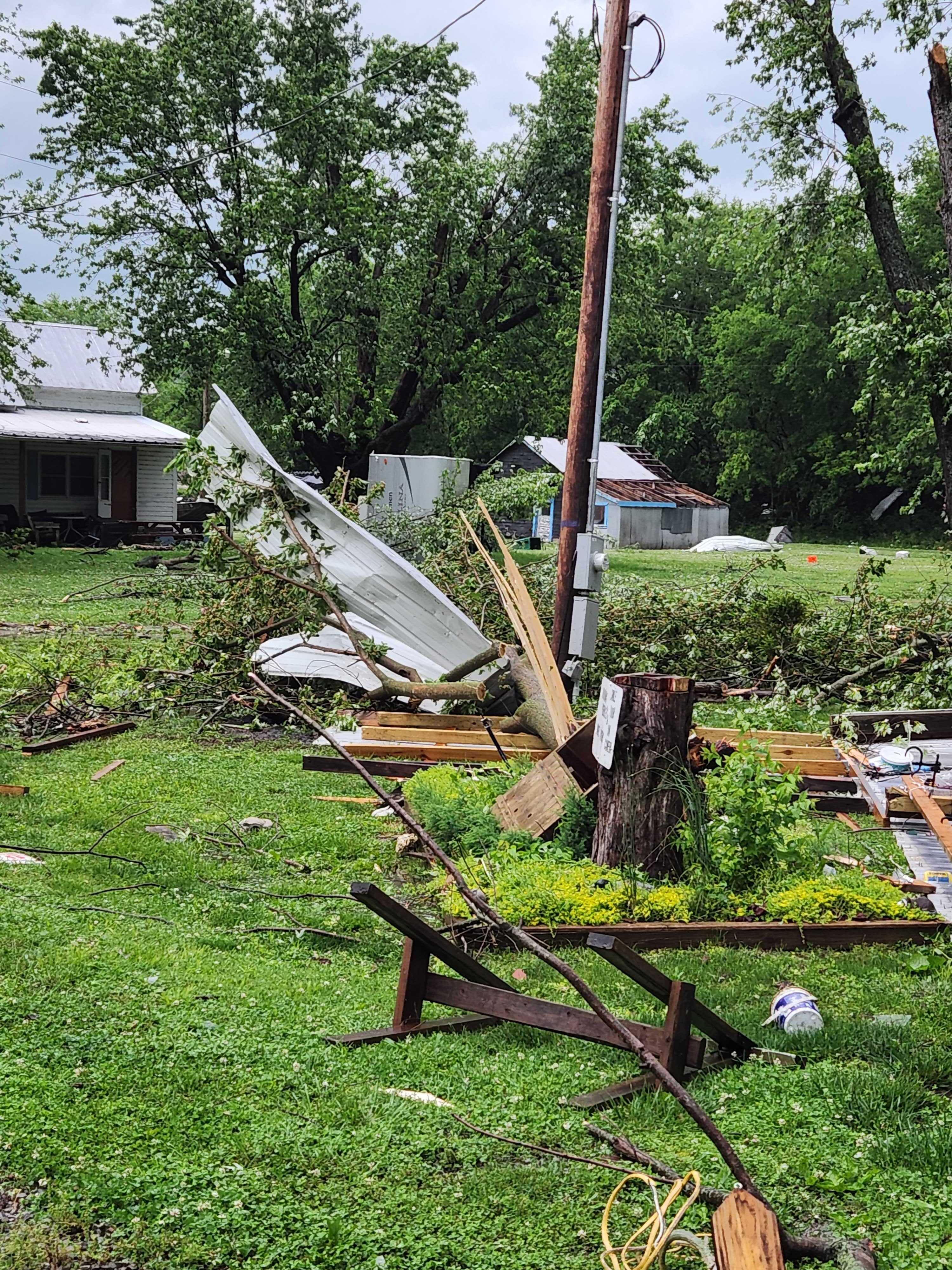
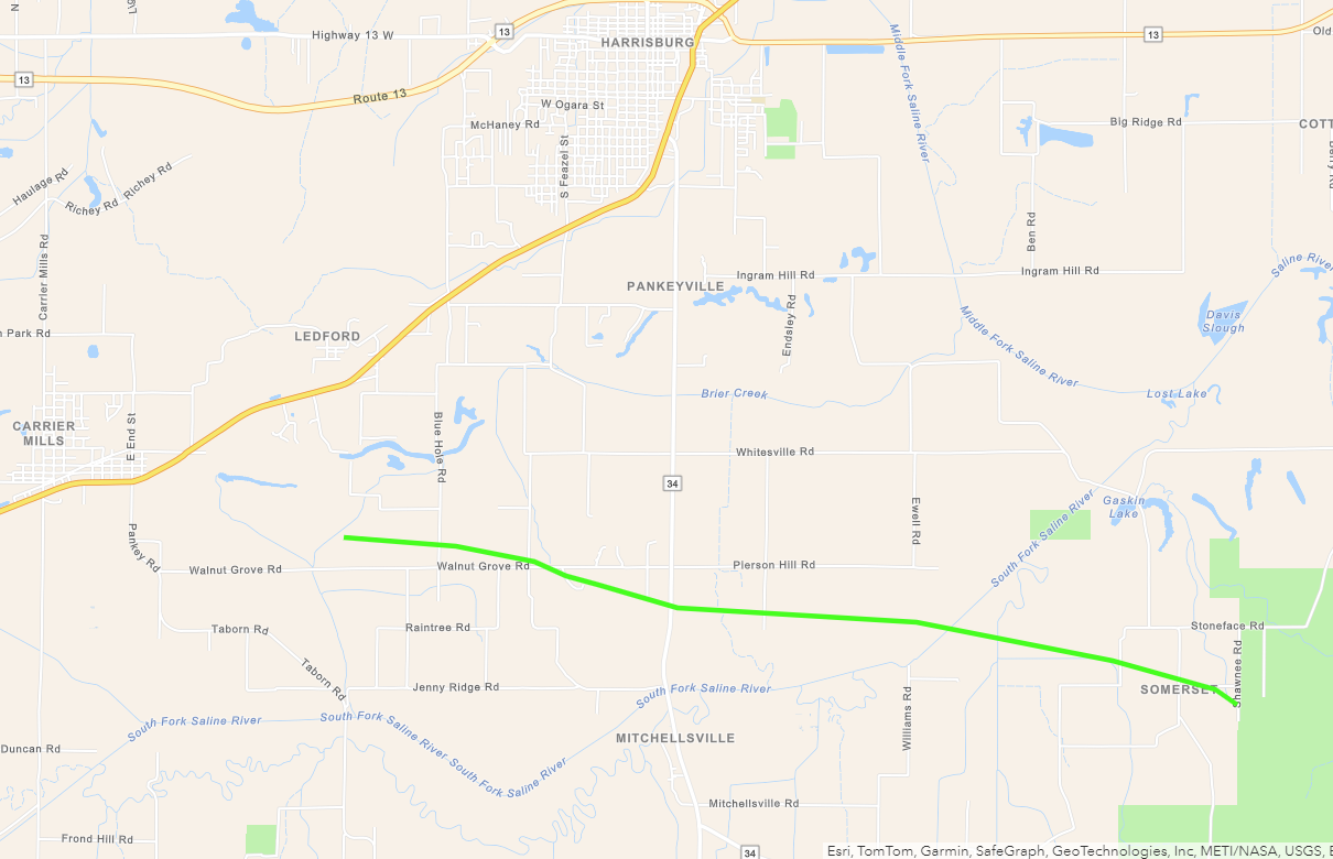
Tornado #4 - Carrier Mills, Illinois
|
||||||||||||||||
|
Tornado #5 - St. Joseph, Kentucky
|
||||||||||||||||
|
Tornado #6 - West Louisville, Kentucky
|
||||||||||||||||
|
Tornado #7 - Rome, Kentucky
|
||||||||||||||||
|
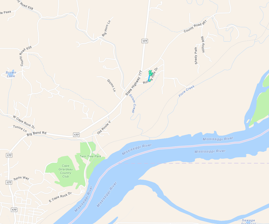
Tornado #8 - Cape Girardeau, Missouri
|
||||||||||||||||
|
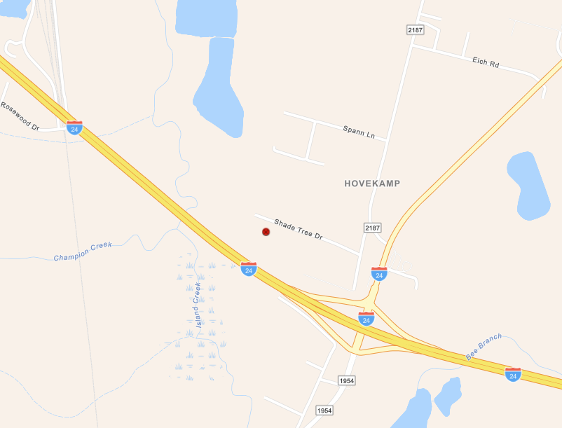
Tornado #9 - Paducah, Kentucky
|
||||||||||||||||
The Enhanced Fujita (EF) Scale classifies tornadoes into the following categories:
| EF0 Weak 65-85 mph |
EF1 Moderate 86-110 mph |
EF2 Significant 111-135 mph |
EF3 Severe 136-165 mph |
EF4 Extreme 166-200 mph |
EF5 Catastrophic 200+ mph |
 |
|||||
Flooding
The majority of our area received 1 to 4 inches of rainfall over a 24-30 hour period. Much of southeast Missouri that doesn't border the Mississippi River largely missed out though, with some areas failing to even pick up 0.25". Meanwhile, localized higher pockets were observed. particularly across western Kentucky. Portions of Marshall, Trigg, southern Christian, and southern Todd counties received 5 to 6 inches! This lead to flash flooding with several roads impassable due to higher water levels. Streams, creeks, and rivers observed a noticeable rise across the region.
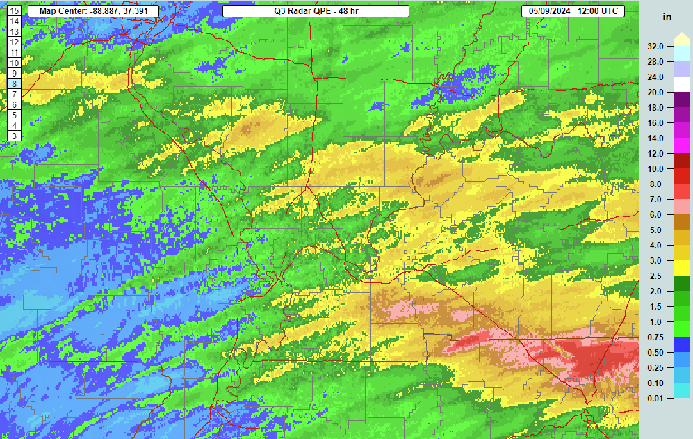 |
| MRMS precipitation estimates for 48 hour period ending at 7 AM on May 9, 2024 |
Photos
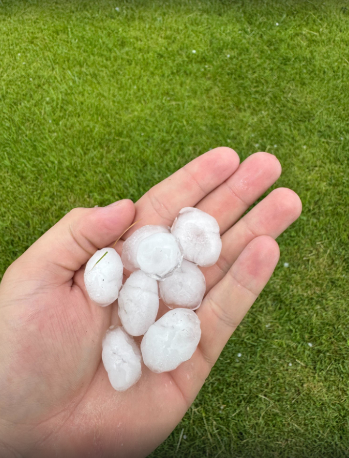 |
 |
 |
 |
| Large hail in Christopher, IL via Luke Saeger | Large hail in Carterville, IL via Beau Dodson | Wind damage in Jefferson County IL via Nick Skaggs | Tornado damage near Carrier Mills, IL via Jacob Dickey |
 |
 |
 |
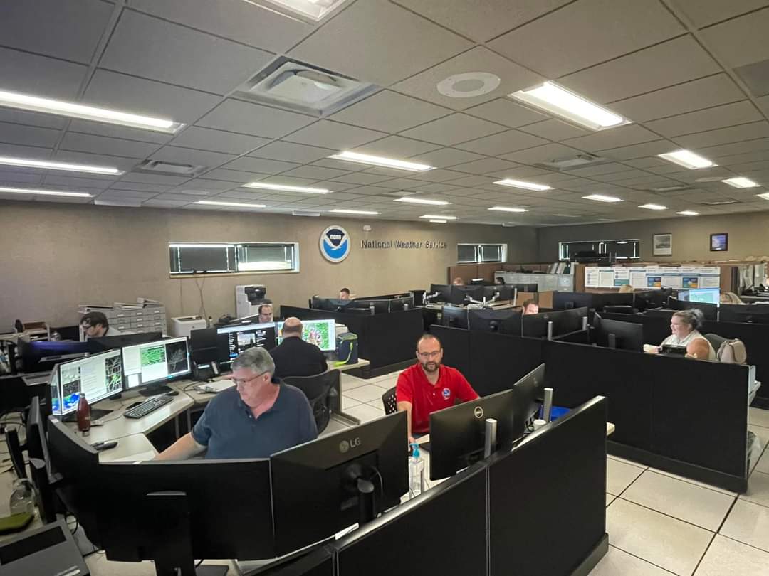 |
| Wind damage in Beechmont, KY via Ricky King | Wind damage in Livermore, KY via Arden Gregory | Tornado damage in Cora, IL (far northwest Jackson County) | NWS Paducah Operations Floor During Event - All-Hands on Deck! |
Radar
Here is a radar loop of the entire event. The loop runs from 10 PM on May 7th through 2 AM on May 9th. Multiple rounds of thunderstorms impacted the region. The most intense storms occurred during the afternoon and evening on May 8th. The first round of storms developed late in the evening on May 7th and sank southward across the region through the overnight. By 6-7 AM, a line of broken storms was oriented along the KY/TN border. This boundary lifted back northward through the morning. By 10 AM, storm activity had largely dissipated which allowed the atmosphere to start rapidly destabilizing, particularly along and south of the aforementioned boundary. Numerous supercells developed between midday and early-mid afternoon (11 AM - 4 PM) across southern Illinois and western Kentucky. Multiple bowing segments then entered portions of southeast Missouri and southern Illinois from mid afternoon through the evening. The first of these entered our western counties around 3 PM, with a second one around 7 PM, and finally a 3rd around 9-10 PM. Supercells continued developing ahead of each of these, gradually sinking south with time and focusing more across western Kentucky by mid to late evening.
Also, here is a radar loop of the main event from 11 AM on May 8th through 1 AM on May 9th.
 |
 |
 |
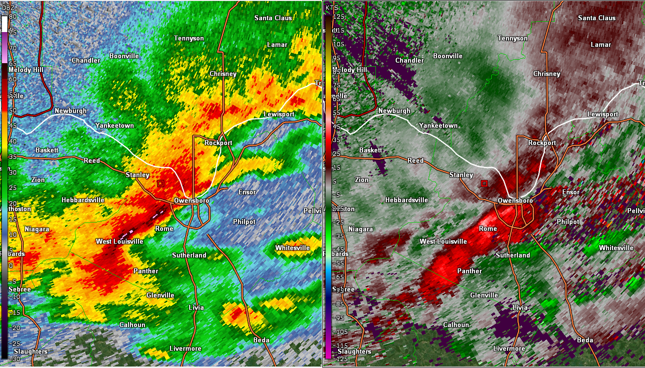 |
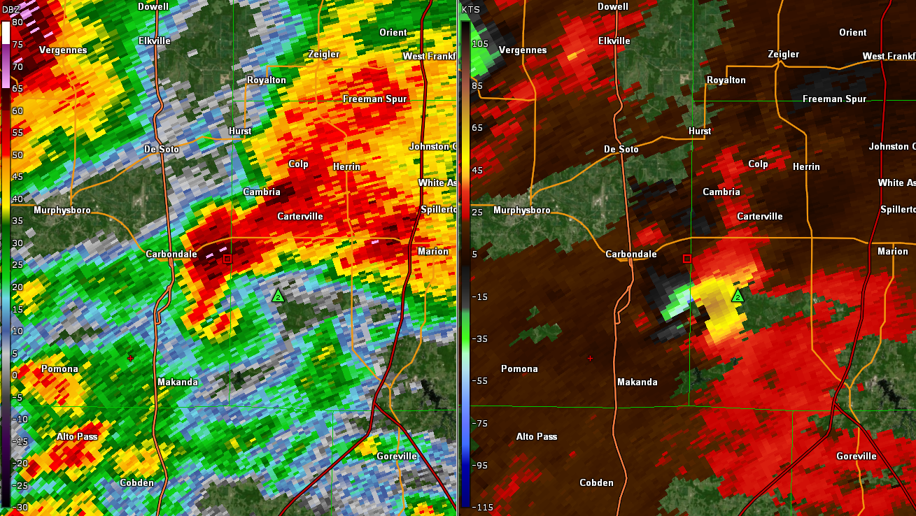
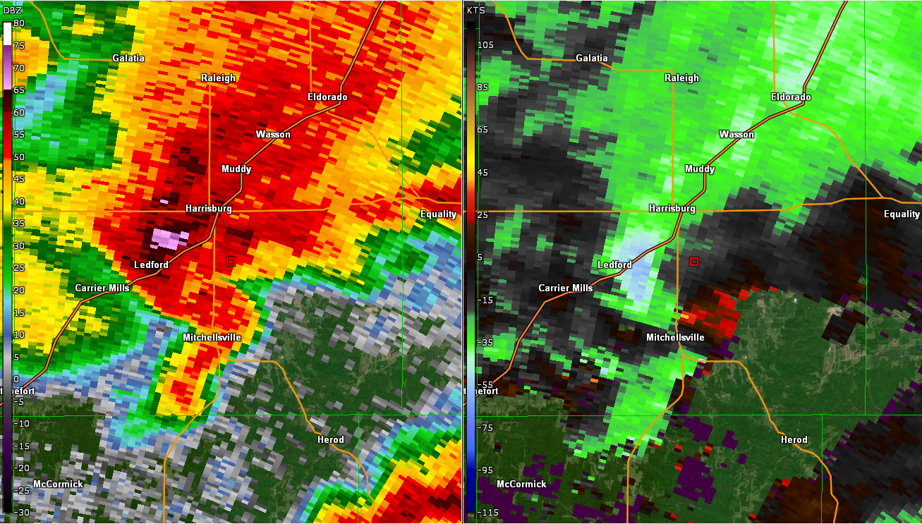
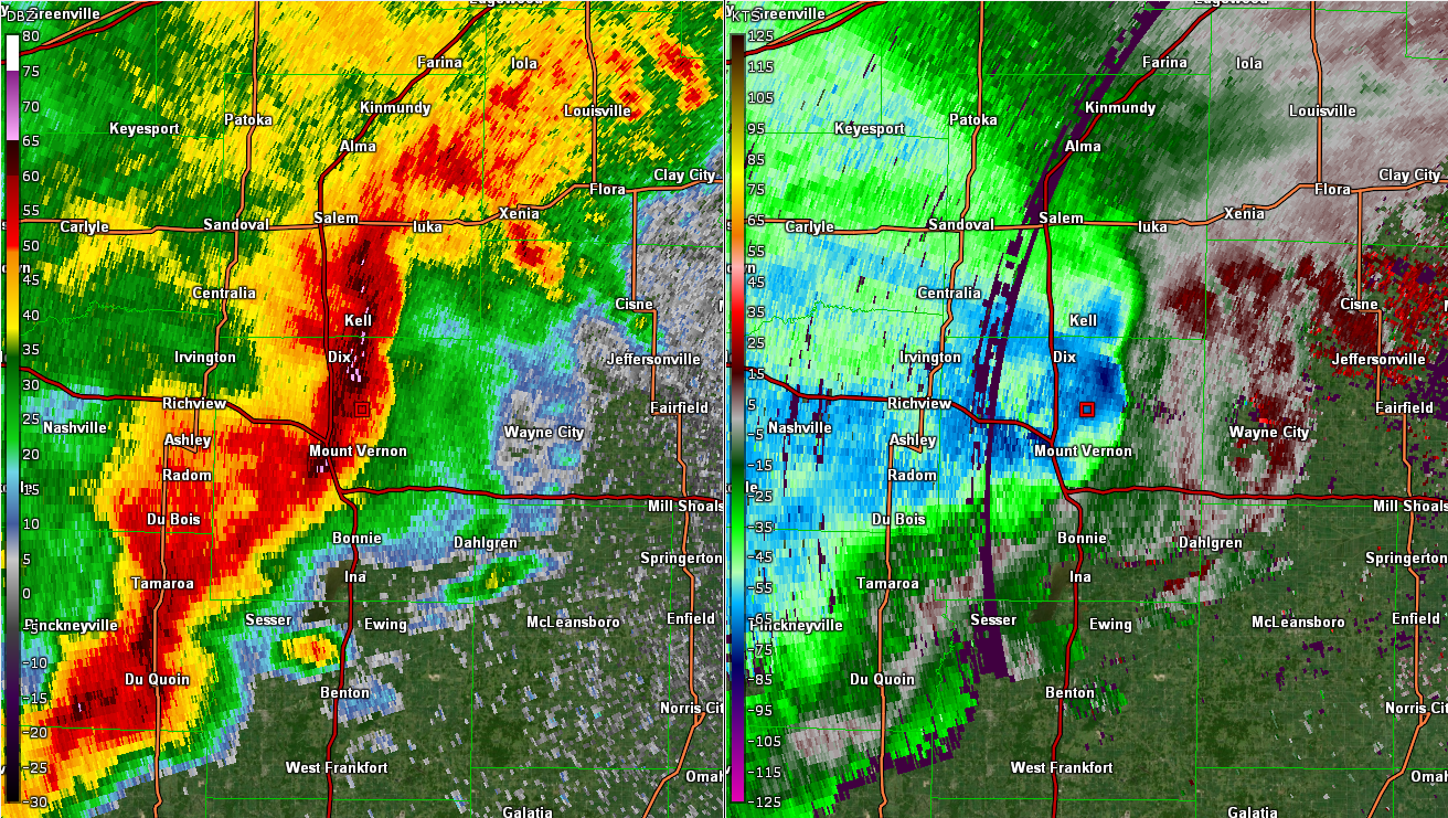
| Reflectivity and Storm Relative Velocity of tornado southeast of Carbondale, IL | Reflectivity and Storm Relative Velocity of tornado near Carrier Mills, IL | Reflectivity and Velocity of bowing line segment moving through Jefferson and Perry counties IL | Line segment producing brief tornadoes and downburst in Owensboro, KY |
Storm Reports
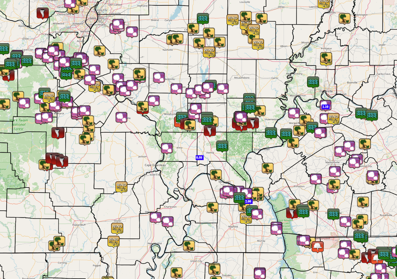 |
| Map of local storms reports. Icons include tornadoes, thunderstorm wind gusts/damage, and hail. |
Preliminary Local Storm Report...Summary National Weather Service Paducah KY 147 AM CDT Fri May 10 2024 ..TIME... ...EVENT... ...CITY LOCATION... ...LAT.LON... ..DATE... ....MAG.... ..COUNTY LOCATION..ST.. ...SOURCE.... ..REMARKS.. 0650 AM Hail 3 S Aurora 36.73N 88.14W 05/08/2024 E1.00 Inch Calloway KY Public Report from mPING of Quarter (1.00 in.) hail. 0725 AM Tstm Wnd Gst 4 NW Brewers 36.81N 88.49W 05/08/2024 M57 MPH Graves KY Trained Spotter Small limbs down. 0731 AM Tstm Wnd Dmg 1 E Cunningham 36.91N 88.87W 05/08/2024 Carlisle KY Emergency Mngr Trees down with power outages. 0750 AM Tstm Wnd Dmg 1 NNW Symsonia 36.92N 88.51W 05/08/2024 Graves KY 911 Call Center Trees down near Symsonia. Time estimated. 0802 AM Tstm Wnd Dmg 3 E Hickman 36.56N 89.14W 05/08/2024 Fulton KY Amateur Radio Large tree limbs down. 0815 AM Flood 4 WNW Benton 36.88N 88.42W 05/08/2024 Marshall KY Public Standing water over Highway 348 near New Harmony Rd. 0816 AM Tstm Wnd Dmg 1 SSE Calvert City 37.02N 88.35W 05/08/2024 Marshall KY Emergency Mngr Trees down on Cedar Street. 0819 AM Tstm Wnd Dmg 4 WSW Calvert City 37.02N 88.42W 05/08/2024 Marshall KY Trained Spotter large trees down over road, above ground pool side blown in. 0819 AM Tstm Wnd Dmg 1 N Calvert City 37.05N 88.35W 05/08/2024 Marshall KY Trained Spotter About four trees snapped or uprooted. 1007 AM Flood 1 ESE Guthrie 36.64N 87.16W 05/08/2024 Todd KY Public Water over the road reported. 1104 AM Hail Ware 37.45N 89.39W 05/08/2024 M0.25 Inch Union IL Trained Spotter Pea size hail. 1115 AM Rain Cypress 37.37N 89.02W 05/08/2024 M0.50 Inch Johnson IL Trained Spotter Heavy Rain, 0.5 inches in approx. 15 min. 1201 PM Tornado Cora 37.81N 89.67W 05/08/2024 Jackson IL NWS Storm Survey *** 1 INJ *** An EF-1 tornado impacted the the community of Cora in extreme western Jackson County, IL. The tornado began south of Cora where it uprooted a tree in the Mississippi River bottomlands and did roof damage to a nearby barn. Moving north, the tornado did significant tree damage in Cora and did roof, siding, and facia damage to a few homes. A couple small barns and a carport were destroyed as well. One manufactured home slid about a foot off its foundation. One person caught outside by the tornado was injured by a falling tree limb. The tornado ended immediately north of Cora. 1202 PM Tstm Wnd Dmg 10 SW Campbell Hill 37.83N 89.67W 05/08/2024 Jackson IL Emergency Mngr *** 1 INJ *** Mobile home shifted off foundation, Older barn roof damage, travel trailer flipped over. Multiple Trees snapped,. 1245 PM Tstm Wnd Dmg 3 S Clifty 36.96N 87.15W 05/08/2024 Todd KY Emergency Mngr Roof damage and an outhouse destroyed, time estimated from radar. 1253 PM Hail 4 WSW Christopher 37.95N 89.11W 05/08/2024 M0.70 Inch Franklin IL Emergency Mngr Corrects previous hail report from 2 NNE Orient. Dime size hail. 1255 PM Hail Buckner 37.98N 89.01W 05/08/2024 E1.00 Inch Franklin IL Public Report from mPING: Quarter (1.00 in.). 0104 PM Hail Benton 38.00N 88.92W 05/08/2024 M0.70 Inch Franklin IL Public dime size hail. 0106 PM Tstm Wnd Dmg 1 S Elkton 36.80N 87.16W 05/08/2024 Todd KY Trained Spotter Possible tornado damage to a barn. 0147 PM Hail Dawson Springs 37.17N 87.69W 05/08/2024 M0.75 Inch Hopkins KY Public Report from mPING: Dime (0.75 in.). 0202 PM Hail Dawson Springs 37.17N 87.69W 05/08/2024 E0.50 Inch Hopkins KY Public Report from mPING: Half-inch (0.50 in.). 0205 PM Tstm Wnd Dmg 4 SE Sturgis 37.50N 87.95W 05/08/2024 Union KY Public Tree fell on a vacant home in Sullivan. 0211 PM Hail Mortons Gap 37.24N 87.47W 05/08/2024 M0.25 Inch Hopkins KY Trained Spotter pea sized hail. 0225 PM Hail 1 S Bremen 37.35N 87.22W 05/08/2024 E0.88 Inch Muhlenberg KY Public 0230 PM Hail 3 SW Bremen 37.32N 87.25W 05/08/2024 E0.88 Inch Muhlenberg KY Public 0244 PM Hail 3 S Drakesboro 37.17N 87.04W 05/08/2024 E0.50 Inch Muhlenberg KY Public Report from mPING: Half-inch (0.50 in.). 0245 PM Hail 3 SSE Drakesboro 37.18N 87.03W 05/08/2024 M1.00 Inch Muhlenberg KY Public 0253 PM Hail 4 ESE Paducah 37.06N 88.57W 05/08/2024 M0.70 Inch McCracken KY Trained Spotter 0253 PM Tstm Wnd Dmg 3 S Drakesboro 37.18N 87.05W 05/08/2024 Muhlenberg KY Public Trees down. 0300 PM Tstm Wnd Dmg 3 SSE Drakesboro 37.17N 87.03W 05/08/2024 Muhlenberg KY Emergency Mngr Trees down, hail damage to vehicles and one house with significant damage, power outages reported. 0300 PM Hail 1 SE Drakesboro 37.20N 87.04W 05/08/2024 M1.75 Inch Muhlenberg KY Public 0300 PM Funnel Cloud 3 SSW Carbondale 37.69N 89.24W 05/08/2024 Jackson IL Trained Spotter Funnel cloud confirmed Tornado warning. 0302 PM Hail 1 ESE Ledbetter 37.04N 88.48W 05/08/2024 E0.25 Inch Livingston KY Public 0305 PM Hail 4 E Hanson 37.42N 87.41W 05/08/2024 M0.50 Inch Hopkins KY Public Report from mPING: Half-inch (0.50 in.). 0308 PM Hail 2 W Ava 37.88N 89.54W 05/08/2024 E0.75 Inch Jackson IL Public 0310 PM Tornado 5 NE Makanda 37.67N 89.17W 05/08/2024 Jackson IL NWS Storm Survey Damage was mainly to tree limbs along a path beginning southeast of Carbondale along Giant City Blacktop. Several large tree limbs were downed on Wagon Wheel Road and County Line Road. Crossing into Williamson County, a large tree was uprooted on Skyhawk Road. Moving east, a barn suffered roof damage on New Hope Road. The tornado lifted after crossing Spillway Road on the southwest side of Crab Orchard National Wildlife Refuge. 0310 PM Hail 1 SW Uniontown 37.77N 87.94W 05/08/2024 E1.00 Inch Union KY Public Report from mPING: Quarter (1.00 in.). 0310 PM Flash Flood Carbondale 37.73N 89.22W 05/08/2024 Jackson IL Public Report from mPING: Street/road flooding; Street/road closed; Vehicles stranded. 0315 PM Tornado 5 SE Carbondale 37.68N 89.14W 05/08/2024 Williamson IL Broadcast Media Video of a tornado shared on social media southeast of Carbondale. Time and location approximate. 0317 PM Tstm Wnd Dmg 7 SE Carbondale 37.66N 89.13W 05/08/2024 Williamson IL Emergency Mngr Trees down. 0319 PM Hail Henderson 37.84N 87.58W 05/08/2024 M0.88 Inch Henderson KY Trained Spotter Nickel size hail. 0321 PM Hail 4 NW Sacramento 37.47N 87.31W 05/08/2024 E0.75 Inch McLean KY Public Report from mPING: Dime (0.75 in.). 0325 PM Hail Carterville 37.76N 89.08W 05/08/2024 M1.75 Inch Williamson IL Public golf ball size hail. 0325 PM Hail 2 W Marion 37.73N 88.97W 05/08/2024 E0.50 Inch Williamson IL Public Report from mPING: Half-inch (0.50 in.). 0332 PM Tstm Wnd Dmg 4 SE Marion 37.70N 88.89W 05/08/2024 Williamson IL Emergency Mngr Trees Down. 0332 PM Tstm Wnd Dmg 5 SE Marion 37.69N 88.87W 05/08/2024 Williamson IL Emergency Mngr Trees Down. 0333 PM Hail 1 E Marion 37.73N 88.93W 05/08/2024 M0.88 Inch Williamson IL Emergency Mngr nickel sized hail. 0333 PM Hail 1 ENE Colp 37.81N 89.06W 05/08/2024 M1.00 Inch Williamson IL Trained Spotter Quarter size hail. 0334 PM Hail 3 W Du Quoin 37.99N 89.28W 05/08/2024 E0.50 Inch Perry IL Public Report from mPING: Half-inch (0.50 in.). 0335 PM Tstm Wnd Dmg Livermore 37.49N 87.13W 05/08/2024 McLean KY Emergency Mngr Corrects previous tstm wnd dmg report from Livermore. Large trees uprooted, tree fell on house. Damage to porch. 0339 PM Tstm Wnd Dmg 3 SE Waverly 37.67N 87.78W 05/08/2024 Union KY Emergency Mngr Telephone pole blown down on KY141 at TL Bishop Rd. 0340 PM Tstm Wnd Dmg Waverly 37.71N 87.81W 05/08/2024 Union KY Dept of Highways Tree limbs down across KY Highway 2094 in the Waverly community. Time estimated by radar. 0346 PM Flood 1 ESE Marion 37.73N 88.93W 05/08/2024 Williamson IL Public Water over road. 0347 PM Flood 1 SSE Marion 37.71N 88.93W 05/08/2024 Williamson IL Public Water over road. 0350 PM Flash Flood 7 SE Waverly 37.64N 87.73W 05/08/2024 Henderson KY Dept of Highways KYTC reports a closure of KY-1557 between mile markers 1 and 3 due to flooding. 0355 PM Hail 4 NW Robards 37.72N 87.58W 05/08/2024 E1.00 Inch Henderson KY Public Report from mPING: Quarter (1.00 in.). 0356 PM Tstm Wnd Dmg 2 SSW Cerulean 36.93N 87.72W 05/08/2024 Trigg KY Trained Spotter Trees down. 0359 PM Hail 6 W Sebree 37.59N 87.63W 05/08/2024 E0.75 Inch Webster KY Public 0401 PM Hail 5 NNW Fort Campbell Nor 36.72N 87.49W 05/08/2024 E1.00 Inch Christian KY Public 0402 PM Tornado 3 SSE Rockcastle 36.86N 87.96W 05/08/2024 Trigg KY Public Video shared on social media of a tornado over Lake Barkley. Location approximate. 0403 PM Tstm Wnd Dmg 5 SSW Breckinridge Cent 37.61N 87.88W 05/08/2024 Union KY Public Trees down reported. 0404 PM Tornado 3 WSW Creal Springs 37.61N 88.90W 05/08/2024 Williamson IL NWS Storm Survey An EF-0 tornado did intermittent damage from the central subdivisions of the Lake of Egypt community to just south of Creal Springs in Williamson County, IL. The great majority of the damage was from downed tree limbs. A couple trees in waterlogged soil were also uprooted. 0405 PM Flash Flood 2 ENE Benton 38.02N 88.89W 05/08/2024 Franklin IL Law Enforcement Flooding is ongoing at Christopher underpass. 0413 PM Tornado 2 ESE Carrier Mills 37.68N 88.58W 05/08/2024 Saline IL NWS Storm Survey Several dozen trees snapped or uprooted along with many large branches broken along the path. A few homes and barns with minor roof damage. One home was slightly shifted off its foundation. 0415 PM Flood 8 WSW Darmstadt 38.05N 87.72W 05/08/2024 Posey IN Public Water over the road. 0416 PM Tornado 5 ESE Carrier Mills 37.66N 88.54W 05/08/2024 Saline IL Broadcast Media Likely tornado damage to a large outbuilding near Highway 145 and Willow Grove Road. Time estimated. 0418 PM Rain 5 SE Reidland 36.97N 88.46W 05/08/2024 M2.00 Inch Marshall KY Public 2 inches of rain storm total. 0419 PM Hail 1 E Harrisburg 37.74N 88.54W 05/08/2024 M1.50 Inch Saline IL Trained Spotter Ping pong ball sized hail. 0420 PM Tstm Wnd Dmg 2 SSE Harrisburg 37.70N 88.53W 05/08/2024 Saline IL Emergency Mngr eagle coal building damaged. 0425 PM Tstm Wnd Dmg 4 NE Rockcastle 36.94N 87.93W 05/08/2024 Trigg KY Trained Spotter Tree down over road, and water over road. 0429 PM Tornado 5 SW Equality 37.68N 88.41W 05/08/2024 Saline IL Emergency Mngr Tornado reported five miles southwest of Equality. 0432 PM Hail 1 NE Pembroke 36.78N 87.35W 05/08/2024 M0.88 Inch Christian KY Trained Spotter nickel size hail. 0440 PM Tstm Wnd Dmg 4 N Equality 37.79N 88.33W 05/08/2024 Gallatin IL Public Report from mPING: 1-inch tree limbs broken; Shingles blown off. 0444 PM Flash Flood 6 NE Gross 37.59N 88.20W 05/08/2024 Hardin IL Public Report from mPING: Street/road flooding; Street/road closed; Vehicles stranded. 0446 PM Flash Flood 2 NW Cadiz 36.89N 87.84W 05/08/2024 Trigg KY Public Stretches of Will Jackson Road is flooded out. 0448 PM Flash Flood 3 S Broughton 37.90N 88.45W 05/08/2024 Saline IL Public Report from mPING: Street/road flooding; Street/road closed; Vehicles stranded. 0450 PM Flash Flood Harrisburg 37.74N 88.54W 05/08/2024 Saline IL Emergency Mngr Several roads flooded with cars in water. 0450 PM Flash Flood Eldorado 37.81N 88.44W 05/08/2024 Saline IL Emergency Mngr Flooding on the road leading to the hospital in Eldorado. Water is into Eldorado High School. Several streets are flooded. 0451 PM Flash Flood 3 N Eldorado 37.86N 88.45W 05/08/2024 Saline IL Public Report from mPING: Street/road flooding; Street/road closed; Vehicles stranded. 0455 PM Flood Harrisburg 37.73N 88.56W 05/08/2024 Saline IL Public Most of a softball field flooded in Harrisburg. 0455 PM Flash Flood 1 W Eldorado 37.82N 88.47W 05/08/2024 Saline IL Public Report from mPING: Street/road flooding; Street/road closed; Vehicles stranded. 0518 PM Flash Flood Simpson 37.47N 88.76W 05/08/2024 Johnson IL Public 0520 PM Flash Flood 3 NW Sturgis 37.58N 88.03W 05/08/2024 Union KY Emergency Mngr Multiple roads briefly closed due to flooding. 0523 PM Flood Harrisburg 37.74N 88.55W 05/08/2024 Saline IL Trained Spotter Water over streets. 0537 PM Hail 6 NE Dixon 37.59N 87.64W 05/08/2024 M0.75 Inch Webster KY Public Report from mPING: Dime (0.75 in.). 0551 PM Tstm Wnd Dmg 1 N Salem 37.27N 88.24W 05/08/2024 Livingston KY 911 Call Center Power lines down over road. 0643 PM Rain Henderson 37.83N 87.58W 05/08/2024 M1.10 Inch Henderson KY Public 0700 PM Hail 5 W Pinckneyville 38.09N 89.48W 05/08/2024 M1.00 Inch Perry IL Public Report from mPING: Quarter (1.00 in.). 0709 PM Hail 3 N Crofton 37.09N 87.50W 05/08/2024 E1.25 Inch Christian KY Public Report from mPING: Half Dollar (1.25 in.). 0712 PM Tstm Wnd Dmg 5 SSW Nortonville 37.12N 87.48W 05/08/2024 Christian KY 911 Call Center Tree down on Madisonville Road near the Mudsink community. Time estimated. 0715 PM Tstm Wnd Dmg 5 SW Dix 38.40N 89.02W 05/08/2024 Jefferson IL Public Report from mPING: 3-inch tree limbs broken; Power poles broken. 0720 PM Hail 3 W Lone Oak 37.04N 88.72W 05/08/2024 E1.00 Inch McCracken KY Trained Spotter 0721 PM Tstm Wnd Dmg Mount Vernon 38.32N 88.90W 05/08/2024 Jefferson IL Emergency Mngr Trees down power outages. 0721 PM Tstm Wnd Gst Mount Vernon 38.32N 88.91W 05/08/2024 E70 MPH Jefferson IL Public Facebook report. 0728 PM Tstm Wnd Dmg 6 NW Bluford 38.41N 88.79W 05/08/2024 Jefferson IL Public Report from mPING: 3-inch tree limbs broken; Power poles broken. 0728 PM Hail 1 NE Lone Oak 37.05N 88.65W 05/08/2024 M0.25 Inch McCracken KY Public pea size hail. 0729 PM Hail 2 NW Lone Oak 37.06N 88.69W 05/08/2024 E1.25 Inch McCracken KY Emergency Mngr Reported at Friendship Road and New Holt Road. 0741 PM Tstm Wnd Dmg 2 W Cisne 38.52N 88.47W 05/08/2024 Wayne IL Emergency Mngr Large tree and power lines down on Highway 161 west of Highway 45. 0742 PM Tstm Wnd Dmg Jeffersonville 38.44N 88.40W 05/08/2024 Wayne IL Emergency Mngr Trees down and power lines down over road. 0742 PM Tstm Wnd Gst 5 NE Johnsonville 38.57N 88.49W 05/08/2024 E70 MPH Wayne IL Fire Dept/Rescue Estimated winds of 60-70 mph with dime size hail. 0744 PM Tstm Wnd Gst 2 ENE Cisne 38.52N 88.40W 05/08/2024 M67 MPH Wayne IL Mesonet Measured from private anemometer. 0748 PM Hail 1 SSW Benton 38.00N 88.92W 05/08/2024 M0.25 Inch Franklin IL Trained Spotter pea size hail. 0754 PM Tstm Wnd Gst 1 E Fairfield 38.39N 88.35W 05/08/2024 M45 MPH Wayne IL Public 0801 PM Hail 5 N Thompsonville 37.99N 88.75W 05/08/2024 M0.50 Inch Franklin IL Trained Spotter half inch hail. 0823 PM Hail Benton 36.85N 88.36W 05/08/2024 M0.25 Inch Marshall KY Trained Spotter pea size hail. 0832 PM Hail Harrisburg 37.74N 88.55W 05/08/2024 M1.00 Inch Saline IL Public 0832 PM Flood 1 W Guthrie 36.65N 87.19W 05/08/2024 Todd KY Emergency Mngr Water over road. 0840 PM Hail Harrisburg 37.73N 88.54W 05/08/2024 M1.75 Inch Saline IL Trained Spotter golf ball sized hail. 0840 PM Tstm Wnd Gst Fort Branch 38.25N 87.57W 05/08/2024 M72 MPH Gibson IN Trained Spotter measured 72 mph wind gust. 0850 PM Tstm Wnd Dmg 2 N Fort Branch 38.27N 87.57W 05/08/2024 Gibson IN Emergency Mngr power lines down over road. 0850 PM Flash Flood Eldorado 37.82N 88.44W 05/08/2024 Saline IL Public Report from mPING: Street/road flooding; Street/road closed; Vehicles stranded. 0858 PM Flash Flood Hopkinsville 36.85N 87.49W 05/08/2024 Christian KY Public Report from mPING: Street/road flooding; Street/road closed; Vehicles stranded. 0930 PM Tstm Wnd Gst 5 NE Robards 37.72N 87.49W 05/08/2024 M57 MPH Henderson KY Fire Dept/Rescue Measured in the Niagara community. 0944 PM Hail 5 S Miner 36.82N 89.52W 05/08/2024 M1.50 Inch New Madrid MO Public Report from mPING of Ping Pong Ball (1.50 in.) hail. 0950 PM Tstm Wnd Dmg Owensboro 37.76N 87.12W 05/08/2024 Daviess KY Emergency Mngr Widespread wind damage across the county. Homes damaged, trees down and power poles snapped. 1000 PM Tstm Wnd Dmg 2 S Oxly 36.56N 90.68W 05/08/2024 Ripley MO Trained Spotter Tree damage, damage to power lines. 1001 PM Flood 3 W Owensboro 37.77N 87.17W 05/08/2024 Daviess KY Public Report from mPING: River/Creek overflowing; Cropland/Yard/Basement Flooding. 1003 PM Flood 3 W Philpot 37.75N 87.05W 05/08/2024 Daviess KY Public Report from mPING: River/Creek overflowing; Cropland/Yard/Basement Flooding. 1020 PM Hail East Prairie 36.78N 89.38W 05/08/2024 E1.00 Inch Mississippi MO Public 1045 PM Tstm Wnd Dmg 2 NW Naylor 36.60N 90.62W 05/08/2024 Ripley MO Public Report from mPING: Trees uprooted or snapped. 1054 PM Flood 2 W Reidland 37.00N 88.56W 05/08/2024 McCracken KY Public Report from mPING: River/Creek overflowing; Cropland/Yard/Basement Flooding. 1115 PM Hail 5 S Aurora 36.71N 88.14W 05/08/2024 E0.70 Inch Calloway KY Public 1122 PM Tstm Wnd Gst 4 N Bernie 36.72N 89.96W 05/08/2024 E50 MPH Stoddard MO Emergency Mngr 1212 AM Hail Hopkinsville 36.85N 87.49W 05/09/2024 M1.00 Inch Christian KY Public 1232 AM Tstm Wnd Dmg 4 NE Trenton 36.76N 87.21W 05/09/2024 Todd KY Trained Spotter Power lines down on Old Trenton Road. 0100 AM Flash Flood Hopkinsville 36.85N 87.49W 05/09/2024 Christian KY Emergency Mngr Widespread flash flooding in multiple locations across Hopkinsville, KY. 0127 AM Flood Cadiz 36.87N 87.83W 05/09/2024 Trigg KY Emergency Mngr Flooding on Old Dover Rd, Donaldson Creek Rd, Maple Grove Rd, Oak Grove Church Rd, and many more roads across the county.
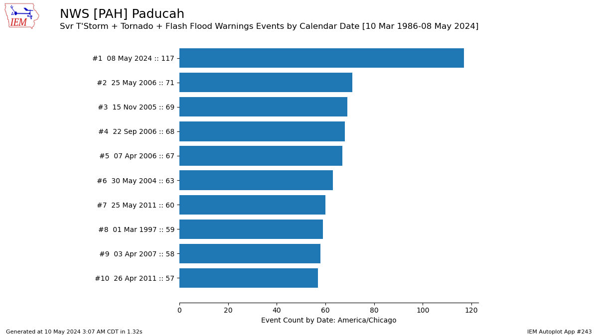
Warning Statistics
It was an extremely busy day monitoring radar and issuing warnings for this event. NWS Paducah ended up issuing an astounding 119 combined warnings (Severe Thunderstorm, Tornado, and Flash Flood) for our 58 county forecast area during this event. 117 of these warnings occurred on May 8th. This was BY FAR the most number of warnings we have issued in a single calendar day, breaking the old record of 71 warnings issued back on May 25, 2006. At the peak of the event shortly after 7 PM, we had 17 total warnings in effect at the same time across parts of our area. Almost everybody was in a warning at some point or another, and many locations received multiple rounds of severe thunderstorms. A severe thunderstorm or tornado warning was in effect for portions of our forecast area for nearly 14 consecutive hours (11 AM May 8th - 1 AM May 9th).
 |
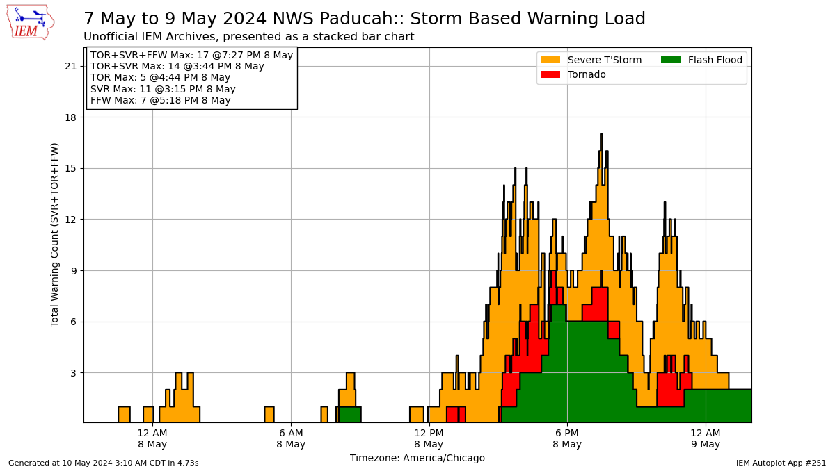 |
| Top 10 calendar days with most warnings issued by NWS Paducah | Bar chart showing the timeline of Severe Thunderstorm, Tornado, and Flash Flood Warnings that were in effect for portions of the NWS Paducah forecast area |
 |
 |
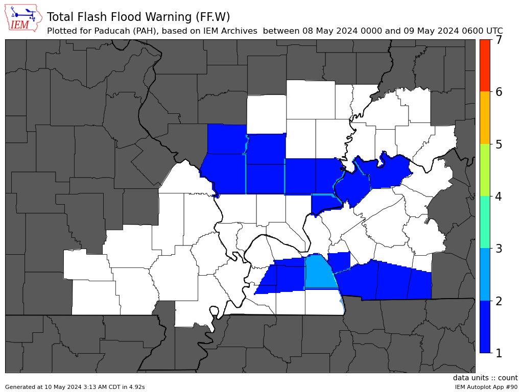 |
| Severe Thunderstorm Warnings | Tornado Warnings | Flash Flood Warnings |
Environment
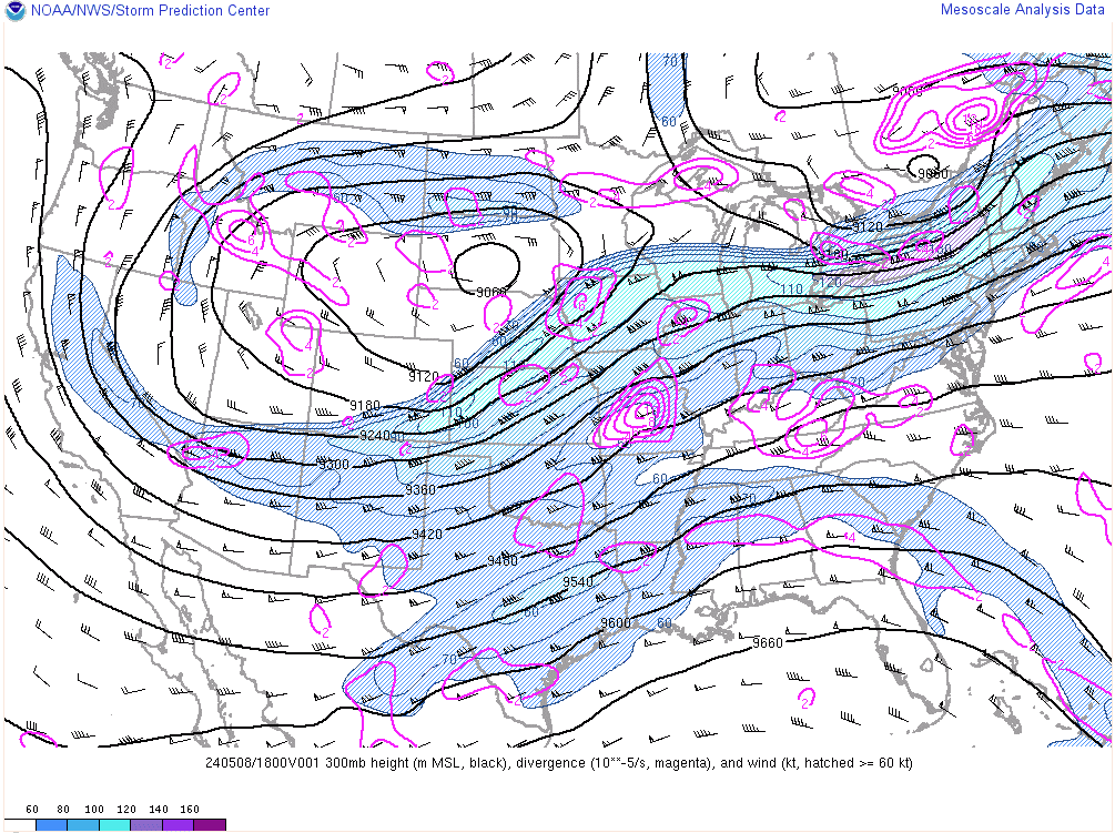
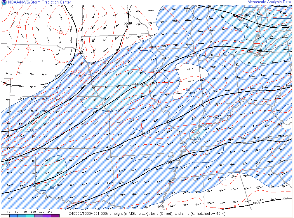
The synoptic environment was characterized by a longwave trough centered across the Rockies with deep-layer southwest flow in place from the Southern Plains into the Ohio Valley and Midwest. A 110 knot upper-level jet extended from Northern Kansas into Iowa, while a 60 knot mid-level jet existed across Northern Missouri into Iowa. At the surface, low pressure was initially located near the Missouri-Kansas border and then lifted to around St Louis by midnight. A warm frontal boundary extended across our region, with a trailing cold front extending southward from the surface low.
 |
 |
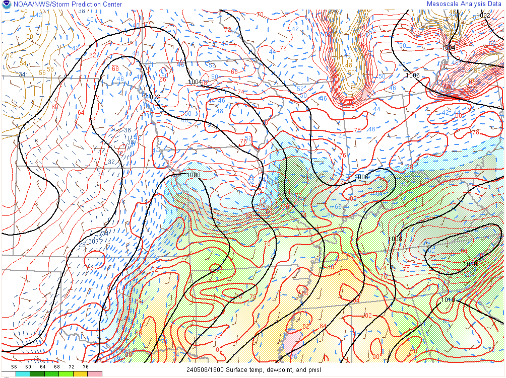 |
| 300mb chart at 1 PM May 8, 2024 | 500mb chart at 1 PM May 8, 2024 | Surface chart at 1 PM May 8, 2024 |
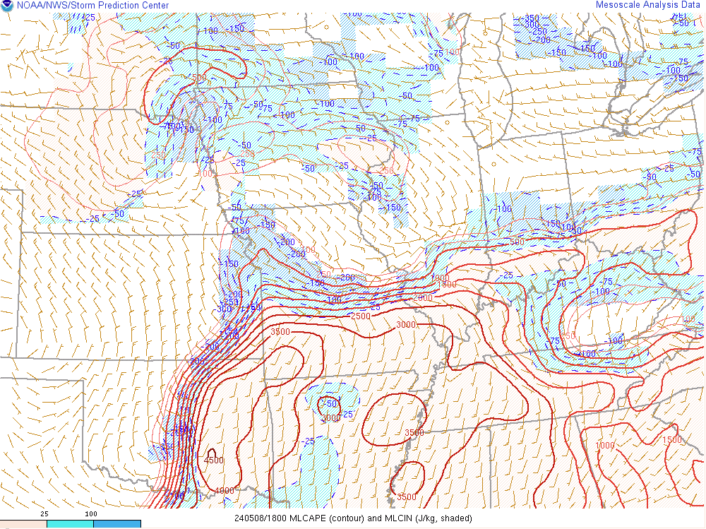
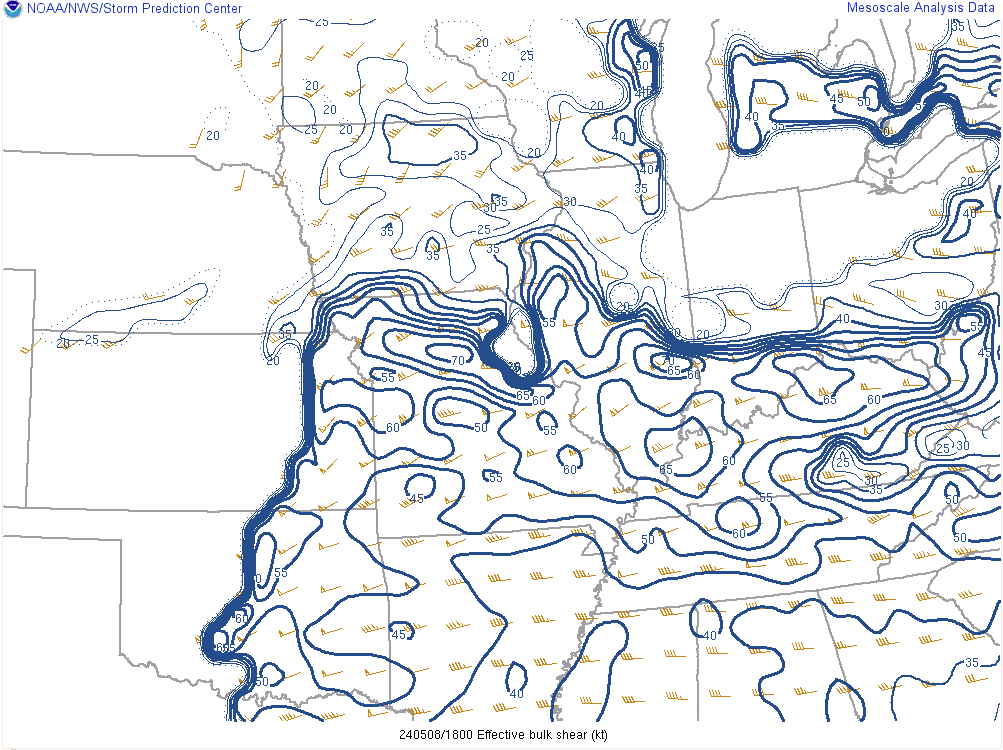
The environment rapidly became unstable by early afternoon, especially across southeast Missouri, southern Illinois, and western Kentucky where MLCAPE values of 2500-3000 j/kg were present. At the same time, we had plenty of deep-layer wind shear present with effective shear on the order of 55-65 kts. Low level shear was lacking a bit though, only around 15 kts. Some increase closer to 20 kts was noted by later afternoon near the KY/TN border and across southwest Illinois into southeast Missouri.
 |
 |
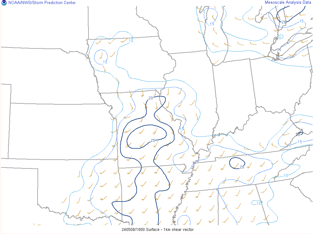 |
| Mixed-Layer CAPE at 1 PM May 8, 2024 | 0-6km effective shear at 1 PM May 8, 2024 | 0-1 km shear at 1 PM May 8, 2024 |
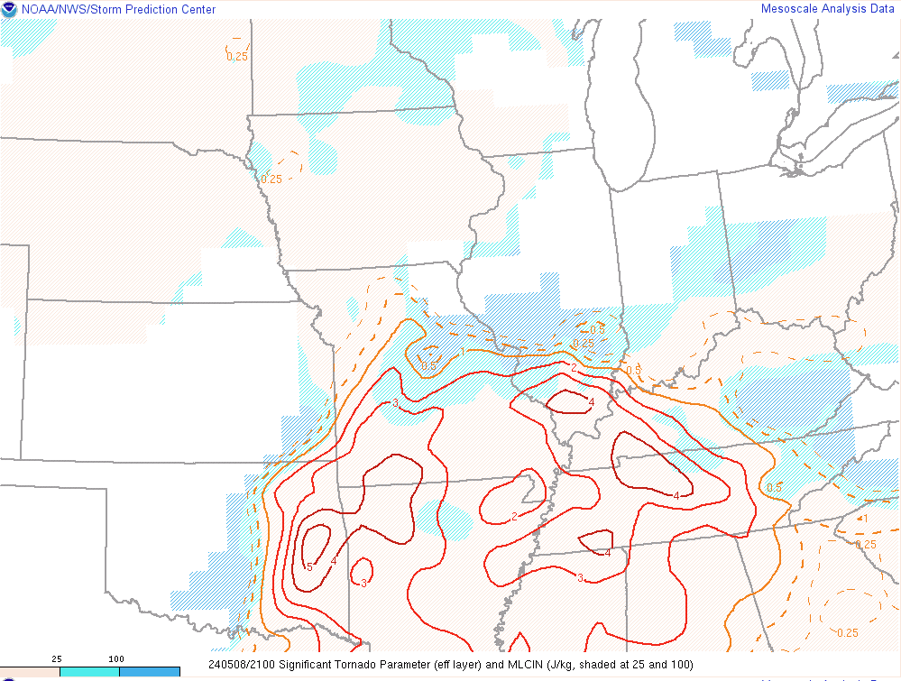
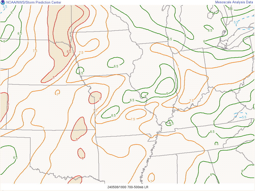
While storm relative helicity was decent across our region during the afternoon, it was greater off to our northwest and southeast. However, STP values of 3-4 were still present which was largely due to the greater deep-layer shear and higher instability. There was also a notable lack of a capping inversion early in the day. This allowed storms to develop early with the predominate storm mode being supercells. Nearly every storm had some rotation with it aloft. Mid-level lapse rates were also rather steep during the afternoon (6.5 to 7.5 C) which helped generate some very large hail.
 |
 |
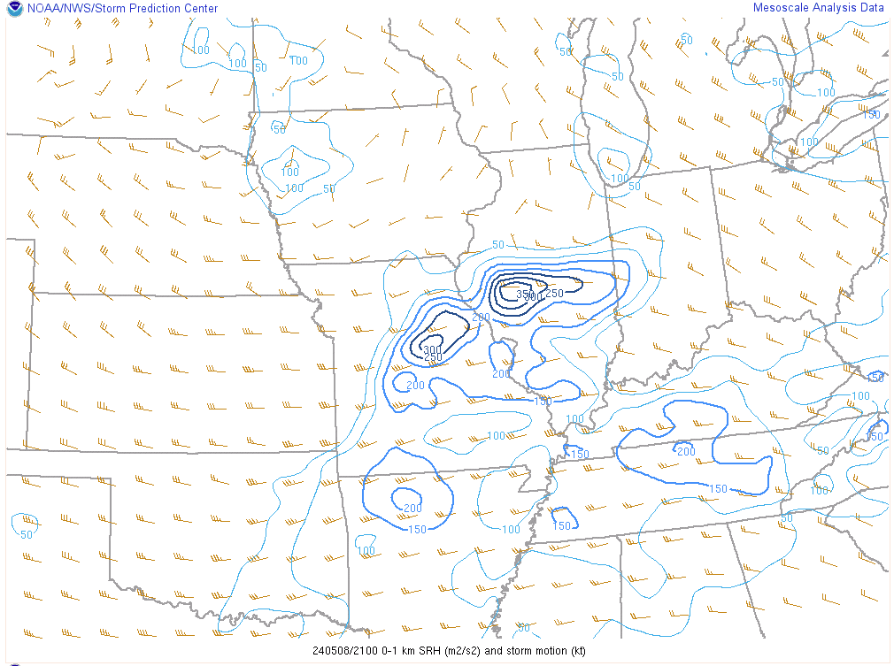 |
| Significant Tornado Parameter (STP) at 4 PM May 8, 2024 | Mid-level lapse rates at 1 PM May 8, 2024 | 0-1 km Storm Relative Helicity (SRH) at 4 PM May 8, 2024 |
Additional Information
The Forecast
 |
.jpg) |
.jpg) |
.jpg) |
| Forecast 36 hours before event | Early AM Forecast on May 8th | SPC Hazard Graphics | Flash Flooding Concern - Early AM Forecast on May 8th |
 |
Media use of NWS Web News Stories is encouraged! Please acknowledge the NWS as the source of any news information accessed from this site. |
|


%20IL%20EF-1.PNG)

%20EF-0.PNG)
%20EF-0.PNG)
%20EF-1.PNG)